

What an absolutely incredible week of weather we experienced across the Front Range. From sizzling record heat, to explosive wildfire growth with towering pyrocumulus clouds blocking out the sun and ash raining from the sky, to unprecedented early season snowfall, to eventual record cold. This week had it ALL! Let’s step through this crazy week in weather and look at just how many long-standing records we broke over the last several days.
We discuss Boulder and Denver weather every single day on BoulderCAST Premium. Sign up today to get access to our daily forecast discussions every morning, complete six-day skiing and hiking forecasts powered by machine learning, access to all our Front Range specific weather models, additional storm updates and much more!

Key Highlights from This Post:
- Many heat records fell across the board during the entirety of Labor Day weekend
- Temperatures dropped some 60 degrees Monday night into early Tuesday with Boulder’s earliest accumulating snowfall on record soon to follow
- Thankfully snow totals came in on the low end of expectations. Otherwise, tree damage could have been much more devastating
- The earliest freeze and several days of record cold were observed, but the extreme cold never materialized due to a lingering blanket of clouds
- We may never see this type of extreme temperature drop accompanied by late-summer snow again in our lifetimes!
W
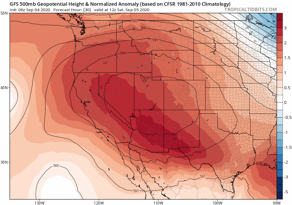
e started this wild roller-coaster ride with record heat over the Labor Day weekend thanks to a large-ridge of high pressure across the area and completely sunny skies. The shift from this extremely warm pattern to an extremely cold one was well-forecasted by our team and the weather models nearly a week in advance! The sharp transition is shown in the GFS 500mb height anomaly forecast animation below. This model was initialized on Thursday night (September 3rd). Of course, we aren’t going to be completely on-board for this type of historic weather a week ahead of time, but confidence grew rapidly as the storm approached.
Following this projected pattern shift, as you know, insanity ensued. Here’s a look at the timeline of the record-setting weather that unfolded in Boulder and Denver this past week!
Saturday September 5th
On this day, Boulder set a new record high temperature for the day hitting 99°F under completely sunny skies. The old record was 97°F set just one year ago.
Denver was even hotter and set a new all-time record high for the month of September hitting 101°F. The previous record was 100°F from September 2, 2019. Obviously this was also a new daily record high. This was also a new record for the latest triple-digit temperature.
Sunday September 6th
Strong winds ahead of the approaching winter storm system caused explosive wildfire growth of the Cameron Peak Fire west of Fort Collins. The tall pyrocumulus cloud was observed by a nearby aircraft:
@NWSBoulder Flew over about 30 minutes ago #CameronPeakFire pic.twitter.com/yiv9N699h3
— Jason Bloch (@JasonBloch) September 6, 2020
The resulting smoke and ash plume from the fire spread southeastward across the entire Denver Metro Sunday afternoon. This smoke plume put a cap on what likely would have been another triple-digit affair across the Front Range.
As of 1PM, it's 96°F at DIA. The smoke plume and ash fallout from the #CameronPeakFire may be the only thing that keeps Denver from re-breaking the all-time monthly record high temperature set just yesterday (101°F)… #COWX #Denverwx pic.twitter.com/K81dbepmeV
— BoulderCAST Weather (@BoulderCAST) September 6, 2020
Air quality measured was some of the worst in the last decade on Sunday. In Boulder, we measured a PM2.5 Air Quality Index of 231 (!) late Sunday afternoon. This is the highest value we’ve seen since installing our sensor 18 months ago.
YOU WIN SOME, YOU LOSE SOME: Thick smoke arrived ~12PM Sunday to Boulder. The giant smoke plume from the Cameron Peak Fire blocked out the sun and likely prevented Boulder from setting a new all-time high temp for the MONTH of September. We only reached 99°F… #Boulderwx #Cowx pic.twitter.com/uQZui9U1fo
— BoulderCAST Weather (@BoulderCAST) September 7, 2020
Boulder set a new record high temperature for the day hitting 99°F for the second time in a row. The old record was 97°F set back in 1959. The amazing part about this record high was that it was reached just after the lunch-hour before a huge plume of smoke from the Cameron Peak Fire engulfed the Boulder area which caused falling temperatures. Nonetheless, this was the latest 99°F day ever reported in Boulder.
Denver tied the record high for the date at 97°F by early afternoon before the very same smoke plume arrived to DIA.
Monday September 7th
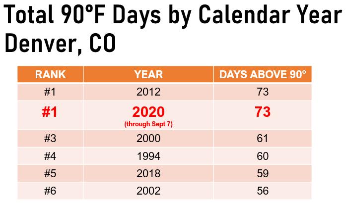
A weak cold front moved through overnight but it wasn’t enough to prevent another day of near-record heat for the Labor Day holiday. With a high of 93°F in Denver, 2020 tied 2012 for the most number of 90-degree days in a calendar year at 73 days.
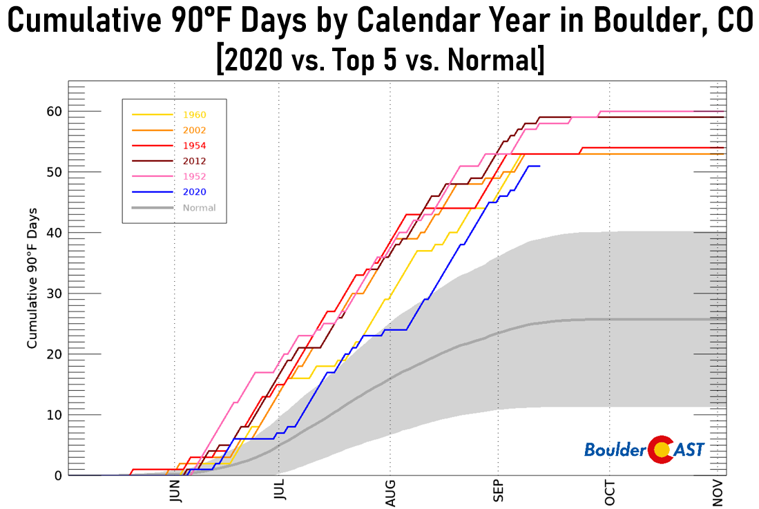
Boulder reached 92°F which came up just a single degree short of tying the existing record high for the date, which was 93°F set back in 2013. This was Boulder’s 51st 90-degree day in 2020, good enough for 6th place all-time since 1897. Keep in mind, we still have about six weeks left where 90°F days could occur, so we may move up the list further!
In the evening hours on Labor Day, gusty winds and the initial cold front blew through with gusts from 30 to 50 MPH across the area. There was a strong smell of manure in the air. Of course you know what that foreshadows!
T-minus 3 hours or so until the changes begin! This front will come in strong, gusty, and dusty with rain showers developing a few hours after #COwx #Boulderwx pic.twitter.com/4wOgZkTWZf
— BoulderCAST Weather (@BoulderCAST) September 7, 2020
Rainfall began after sunset Monday night and continued lightly through much of the night. As the front blew through, there were even a few thunderstorms that developed, just clipping the northeastern Metro area.
As of 9:30 PM Monday, thunderstorms are popping northeast over Denver late this evening along a convergence line. Most of the storm action should stay out that direction. Upslope precipitation will fill in shortly along the Foothills and adjacent Plains before midnight #COwx pic.twitter.com/CUZFldEDoq
— BoulderCAST Weather (@BoulderCAST) September 8, 2020
Tuesday September 8th
This was the day we had been waiting for…the day it would get cold enough for rain to change-over to our historic first snow across the area. The forecast didn’t play out quite as expected with rain persisting longer than anticipated in some areas and only modest snow accumulations in the higher terrain during the day. At our weather station, temperatures hovered around 33°F the entire day with rain and snow mixing back and forth.
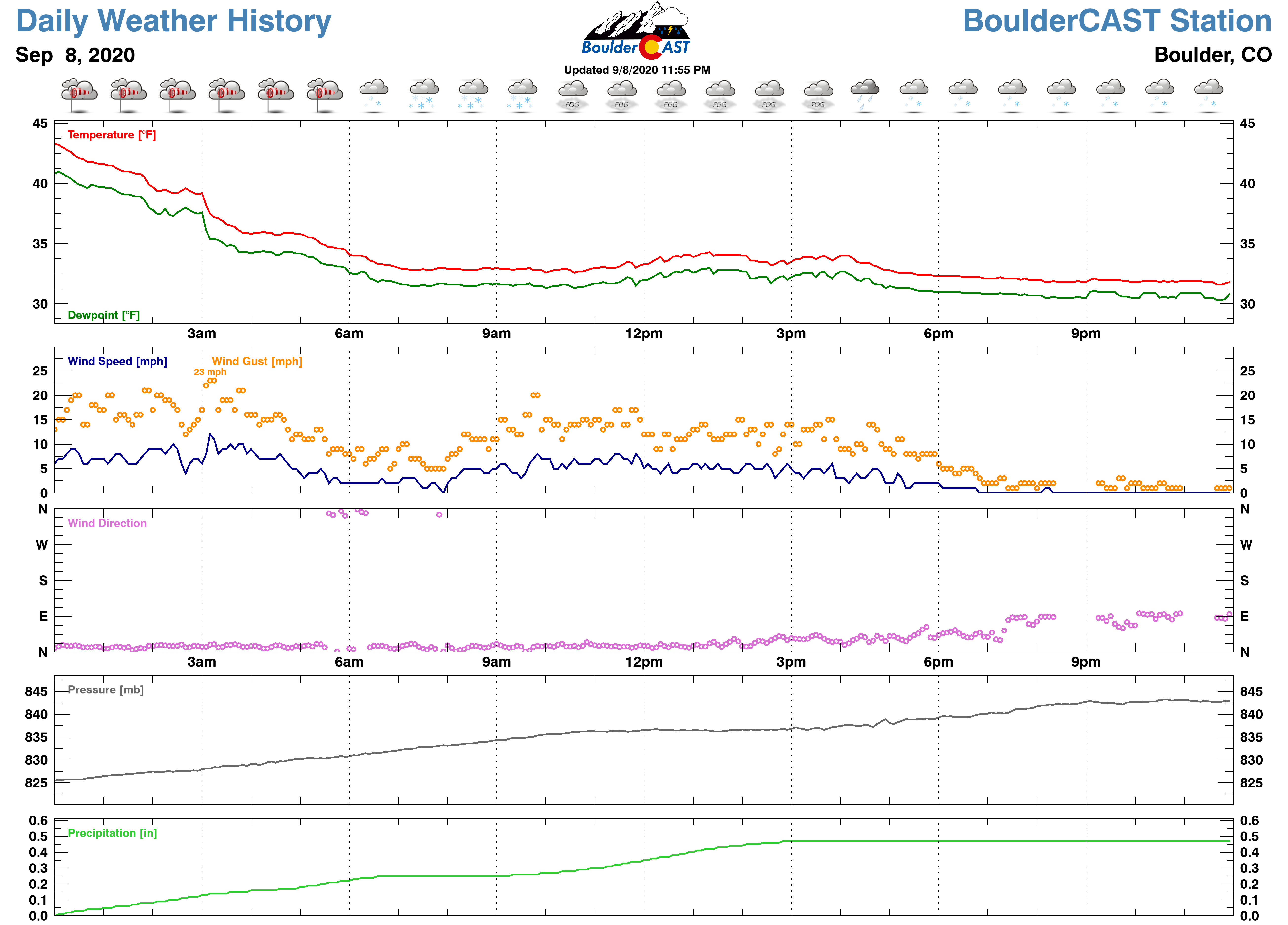
Afternoon temperatures were some 60 degrees colder on Tuesday compared to Monday. The mid-afternoon temperature in Boulder was several degrees lower than even the existing record low temperature for the date, a sign of just how incredibly cold this airmass was!
Welcome to Colorado, where the temperature drops 59°F in about ~15 hours and it snows in the summer! #COwx
92°F (4PM Monday) –> 33°F (7AM Tuesday)
More regional graphics: https://t.co/bg05MB0SxZ pic.twitter.com/KAWWtMG2B0
— BoulderCAST Weather (@BoulderCAST) September 8, 2020
Ultimately, more widespread lift and upslope did reach the Front Range late Tuesday afternoon into Tuesday evening spreading accumulating snow to the entire region. Boulder reported 1.7″ of new snow by 6:00PM Tuesday, which is the cut-off for the date’s climate record. As such, this storm will go down as Boulder’s earliest ever accumulating snowfall and the second earliest occurrence of snow. Previously, a trace of snow had been reported on September 3, 1961. Obviously the 1.7″ of snow for September 8th was a new daily snowfall record as well.
Tuesday marked only the 3rd time in Boulder’s recorded history that snow occurred the day after a 90-degree day. Don’t forget, it was 92 degrees on Monday, but it was 32°F and snowing by sunrise Tuesday! Yikes! This drop in temperature of 60°F tied for the largest ever 1-day temperature swing during the month of September. The other 60°F swing came back on September 11-12, 1974 when temperatures dropped from 91°F to 31°F (it snowed that day too!). This 32-degree reading in Boulder on Tuesday also notched September 8th as the earliest freeze ever and also was a new record low for the date. The prior record was 35°F set back in 1941.
Denver reported 1.0″ of snowfall this day which tied for the second earliest accumulating snowfall (earliest was September 3, 1961 at 4.2″).
Wednesday September 9th
Light but persistent wet snow continued through the night into Wednesday morning. The sunrise revealed a plethora of tree damage across the Boulder area, which was hit particularly hard with up to 4 to 6″ of wet snow, the most of any “Plains” city in our region.
PINPOINT WX: Heavy snow taking down limbs, blocking streets in Boulder. Details #KDVR #KWGN. pic.twitter.com/dSvoIAnvRP
— jimhooley (@jimhooley) September 9, 2020
Xcel was reporting numerous power outages across the city.
There are a ton of small and large power outages for Xcel customers in Boulder. Beware of dark intersections or tree limbs down in roads. pic.twitter.com/DwvzBVCUWC
— Jayson Luber (@Denver7Traffic) September 9, 2020
Plagued by low clouds, lingering light snow, and the bitter cold airmass, Boulder set a handful of new daily temperature records on Wednesday. This included a new record low of 30°F and a new record low maximum of 42°F. Wednesday also notched a new daily snowfall record with 4.0″ falling in Boulder, most of which occurred during the overnight and morning hours.
By afternoon, we started to get a complete picture of just how much early season snow had fallen across the Front Range. As promised, it was a slushy wonderland everywhere! Between Tuesday and Wednesday, Boulder recorded a storm total of 5.7″, while Denver (DIA) saw just 1.0″. Shown below is our snowfall forecast map issued Sunday morning with actual storm totals overlaid in boxes. Green boxes indicate that our forecast verified to within one inch of the observed snowfall. Red did not.
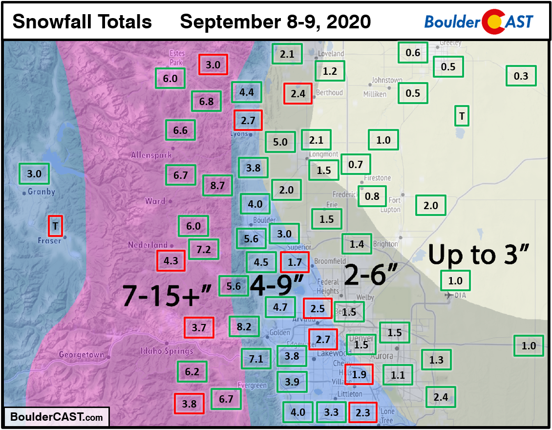
We had fairly good forecast verification across the Metro area, thought snowfall totals overall did come in on the lower side. We have no hard feelings with Mother Nature on this one. We’ll gladly take an “under-performer” this time of year! As we saw in Boulder, the consequences of just 4 to 6″ of heavy wet snow can be severe this time of year. The bulk of the Denver Metro area received between 1 to 4″ of snow with only minor tree damage reported outside of Boulder and the far western suburbs of Denver.
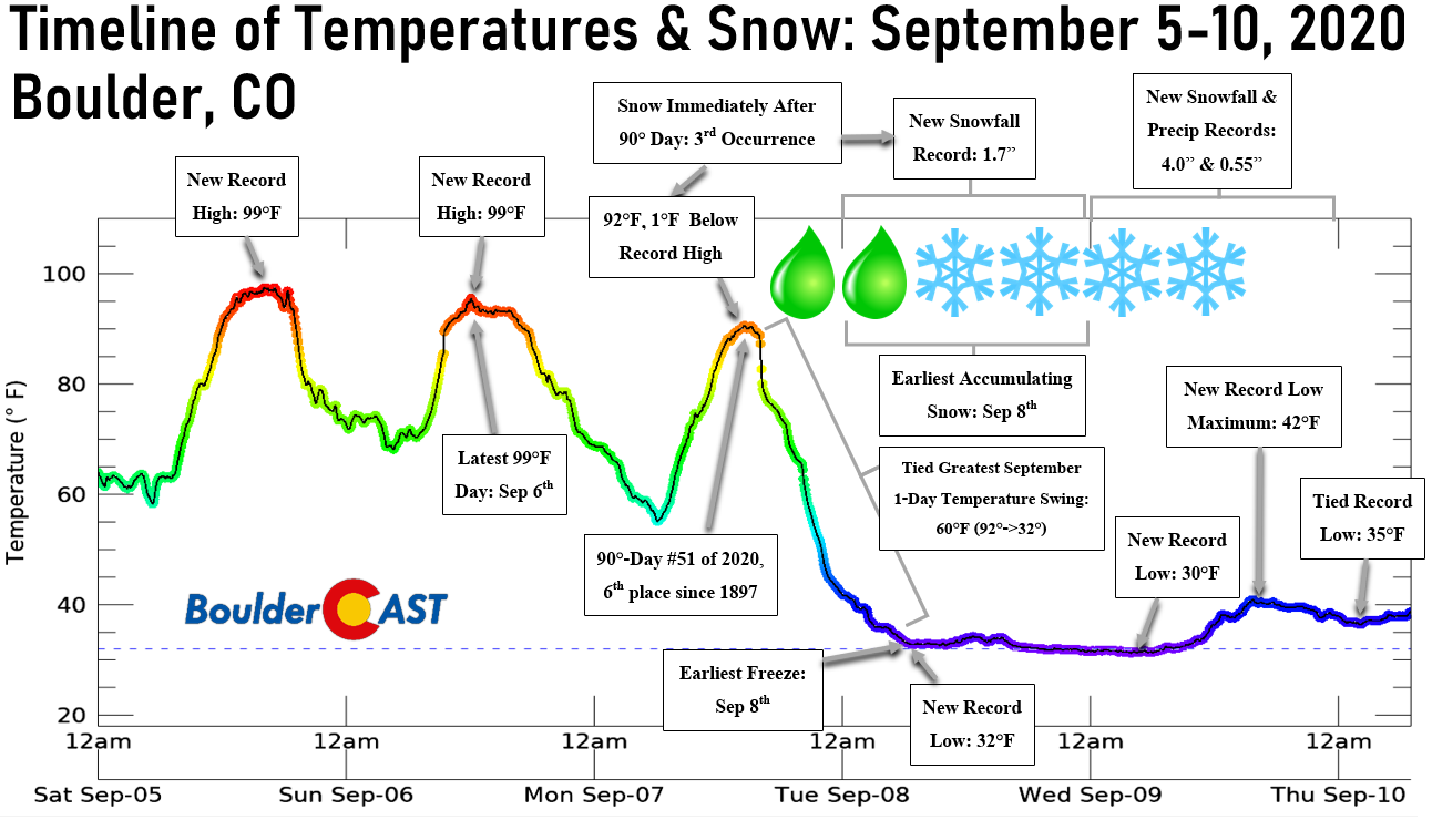
That graphic below summarizes everything that unfolded in Boulder this week, with nearly a dozen records challenged or obliterated. What a wild ride it has been! That’s literally all we can say at this point! A winter storm as remarkably early as this should only occur about once every fifty years in our area. Throw in the record heat beforehand, and this type of event may never happen again in our lifetimes. Hopefully that means we won’t be forecasting late-summer snow again anytime soon!
If there is one silver-lining from this entire debacle Mother Nature threw at us, it’s that temperatures across the Plains never dropped as low as they could have. The persistence of the remnant low near the Four Corners region kept a blanket of clouds across the Front Range beginning Monday night and those clouds will be with us through Friday morning. It’s these clouds that really prevented the temperatures from plummeting when the airmass was coldest over Colorado, especially when there was fresh snow on the ground. This aspect of the storm was poorly forecasted by the models, at least until sometime on Monday. Before this, our storm system was expected to quickly exit eastward paving the way for clearing skies on Wednesday and Thursday which could have brought temperatures way down into the 20’s. We can hope that this “good fortune” may have helped local farmers and ranchers weather the storm a little better. We’ll find out in another month or so if any local pumpkin patches have anything to offer us for the changing seasons.
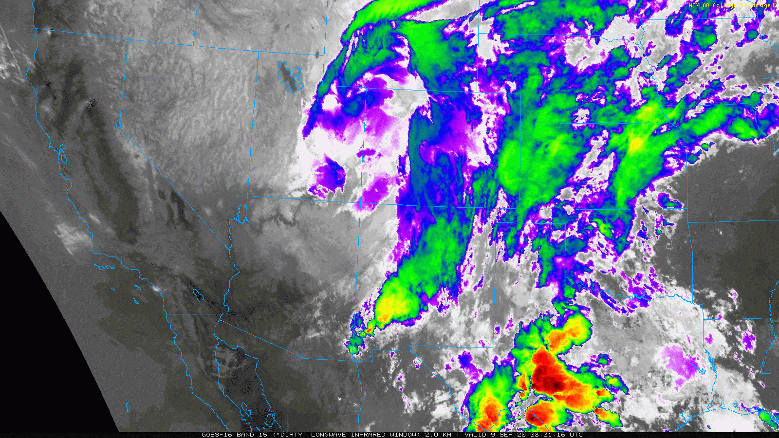
GOES-East infrared satellite animation from Wednesday morning (9/9/20)
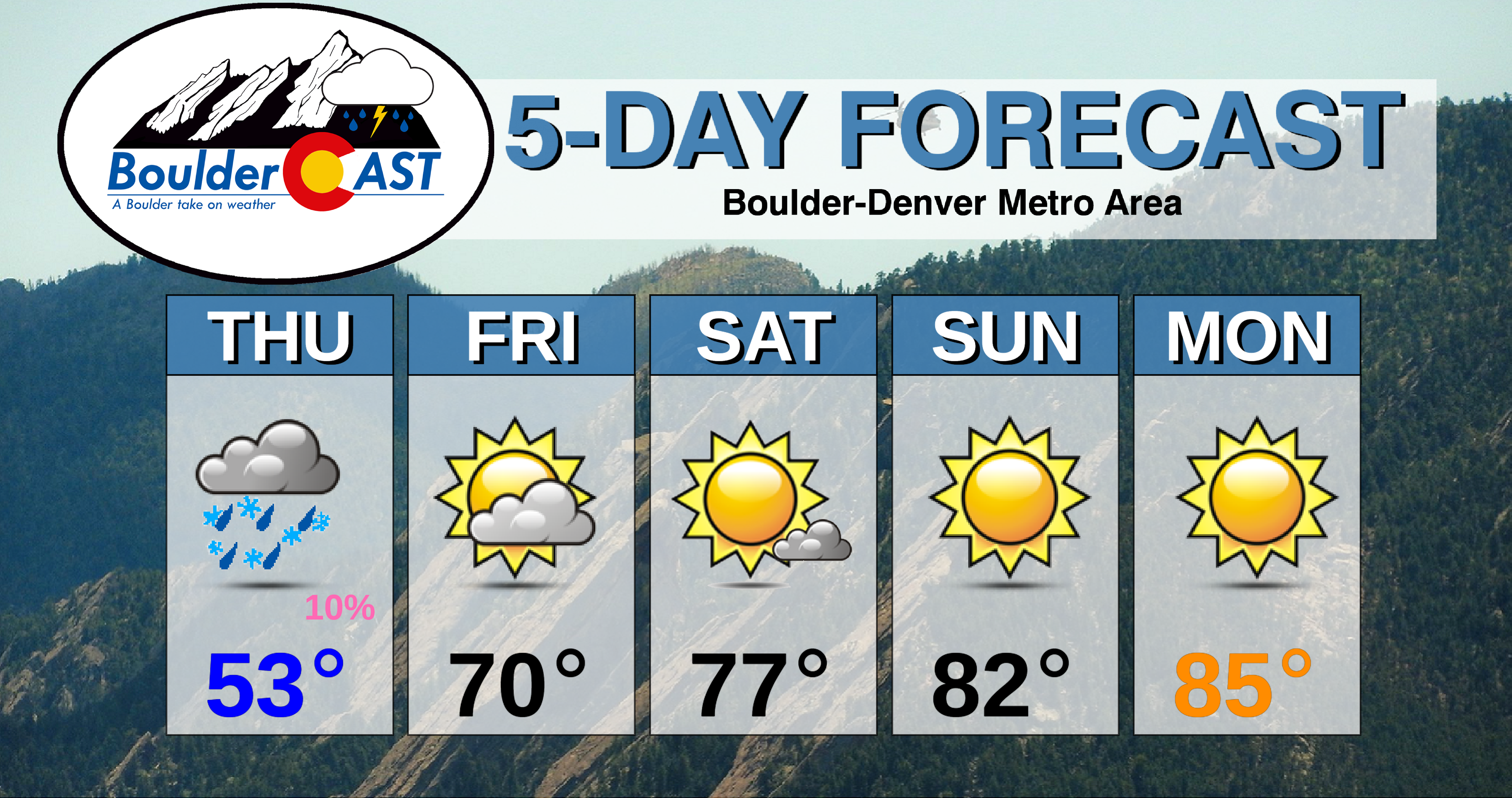
Have a good end to the week. A warming and drying trend is already underway. We’ll be back on Monday with our usual weekly outlook. Enjoy! Subscribe to BoulderCAST to get instant email notifications when our new forecasts go live, and don’t forget to follow us on Facebook or Twitter.
We discuss Boulder and Denver weather every single day on BoulderCAST Premium. Sign up today to get access to our daily forecast discussions every morning, complete six-day skiing and hiking forecasts powered by machine learning, access to all our Front Range specific weather models, additional storm updates and much more!
.
Spread the word, share Colorado’s crazy weather:
.


You must be logged in to post a comment.