
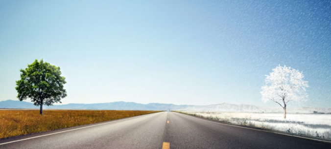
It’s hard to believe that we could go from sizzling record heat to snow in a little under 36 hours, but that is just what most weather models are indicating early next week! A major autumn storm system is progged to drop southward putting a giant, bitter cold bullseye right along the lee of the Rockies. With this strong and cold early-season storm system, a period of intense lift and upslope will likely unfold across the Front Range producing widespread rain showers and even the threat of snow all the way down to the lower elevations of the Boulder-Denver area. Needless to say, it’s definitely going to be an interesting forecast heading into early next week! Let’s talk about it….
At a Glance:
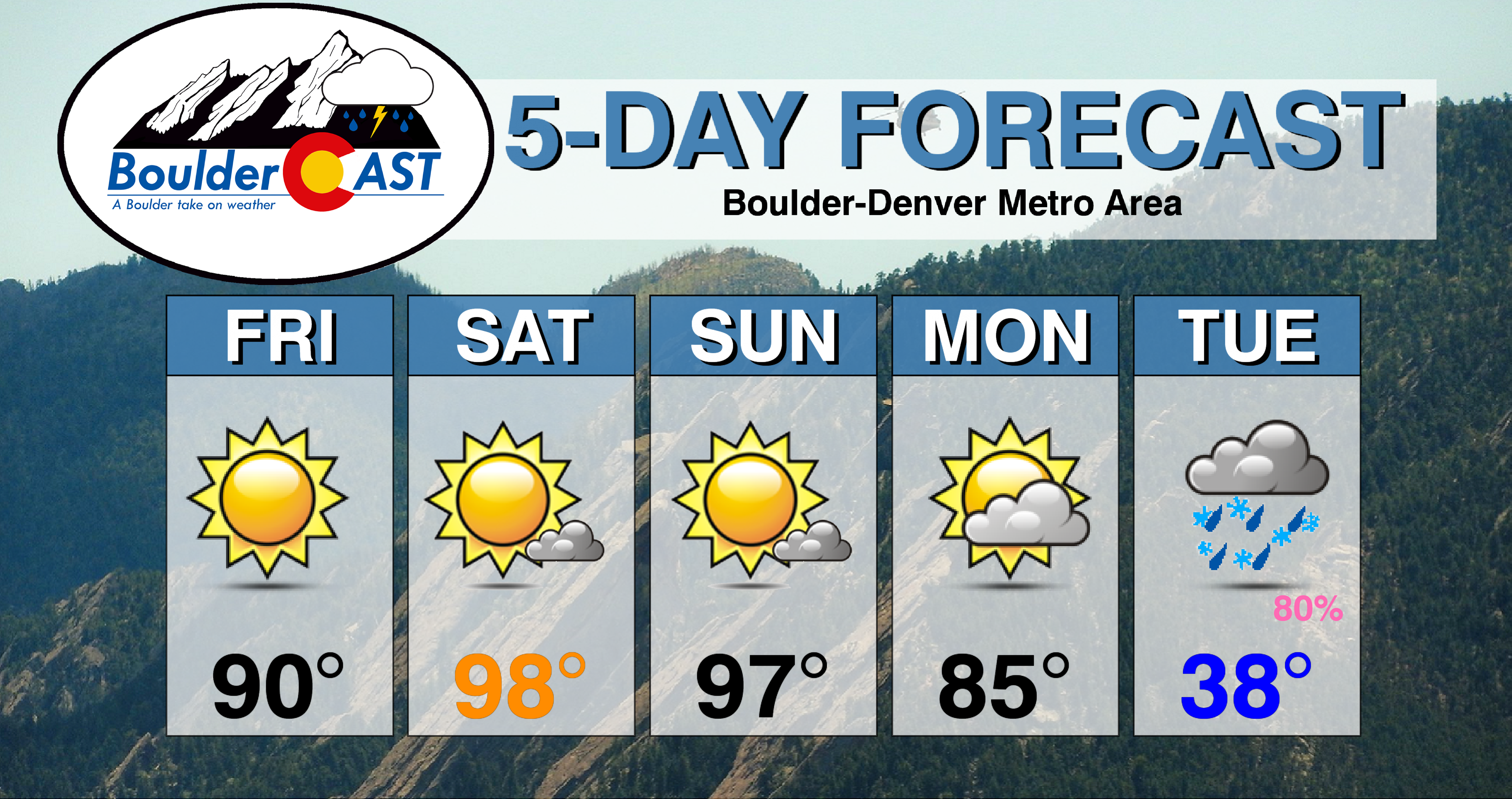
- A “mega ridge” will be present this weekend leading to near-record heat well into the 90’s through Sunday
- A strong and potentially historic autumn storm system will bring BIG changes to Colorado Monday evening
- We’re fairly confident that most areas will see some snow on Tuesday with temperatures in the 30’s for highs
- Uncertainty in potential snowfall amounts remains high given the time of year and four-day lead time
Help support our team of Front Range weather bloggers by joining BoulderCAST Premium. We talk Boulder and Denver weather every single day. Sign up now to get access to our daily forecast discussions each morning, complete six-day skiing and hiking forecasts powered by machine learning, first-class access to all our Colorado-centric high-resolution weather graphics, bonus storm updates and much more! Or not, we just appreciate your readership!

The warm before the storm
If you thought the conclusion of meteorological summer on August 31 would mean an end to the intense summer heat we’ve experienced in 2020….you were wrong. Mother Nature has architected a nasty late-summer heat wave for the Front Range beginning on Friday.
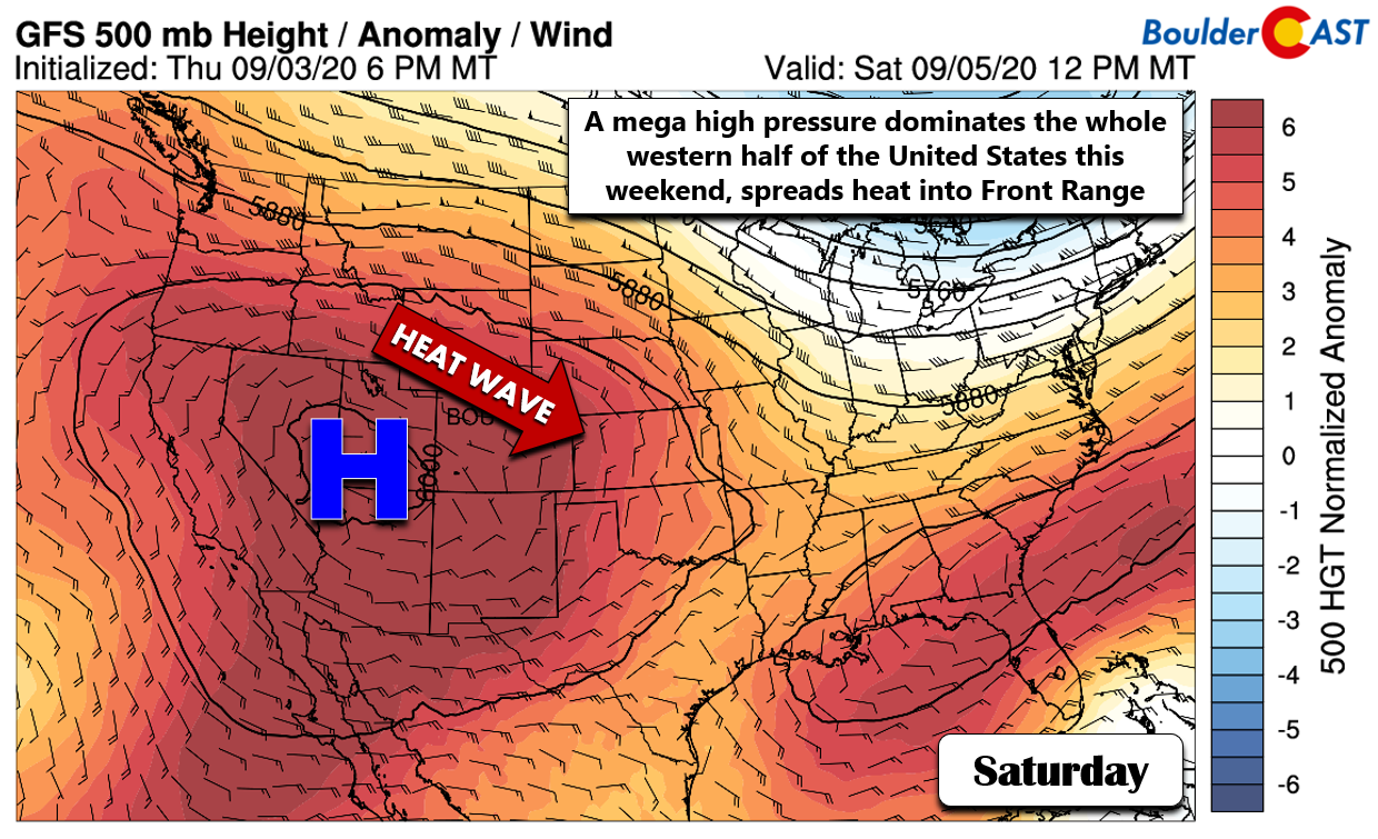
Yes this incoming heat wave is related to an extremely strong ridge of high pressure across the western United States. Same story, different day….as has been the case all summer long. This particular ridge is something we are calling an unofficial “mega ridge”. At its strongest on Saturday, the center of the high pressure over Utah will have a geopotential height above 6030 meters at the 500mb level! This is incredible for early September with these extremely anomalous heights indicative of a very warm airmass below. This ridge has persisted to our west for more than a week already with very dry air contained within. This has led to day after day of full solar heating which has cumulatively warmed this airmass over a massive area. In short: it’s gonna get very hot!
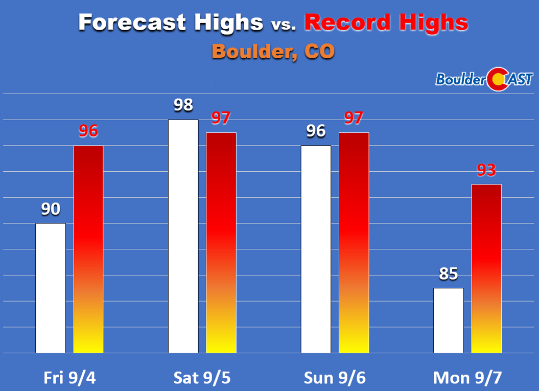
After the brief cooldown we saw on Thursday, the ridge will win out Friday into Monday across Colorado with a sharp increase in our temperatures for the holiday weekend under mostly sunny skies. Temperatures will return to the 90’s Friday and even soar further into the upper 90’s on Saturday and Sunday. This magnitude of heat in early September will be flirting with record highs for many cities across the Metro area. In Boulder, the record high to beat both days is 97°F. It will be close based on our forecast temperatures:
Very big changes coming Monday night into Tuesday
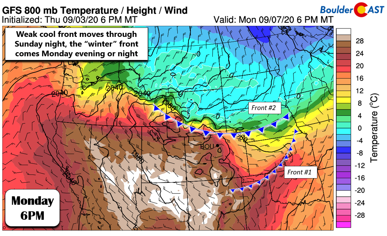
As quickly as the heat built into our area, it will leave early next week. The animation below shows forecasted 700mb temperatures (around 10,000 elevation) from Sunday into Thursday. The “warm before the storm” quickly gets ousted by impressive sub-freezing temperatures in our region Monday night into Tuesday.
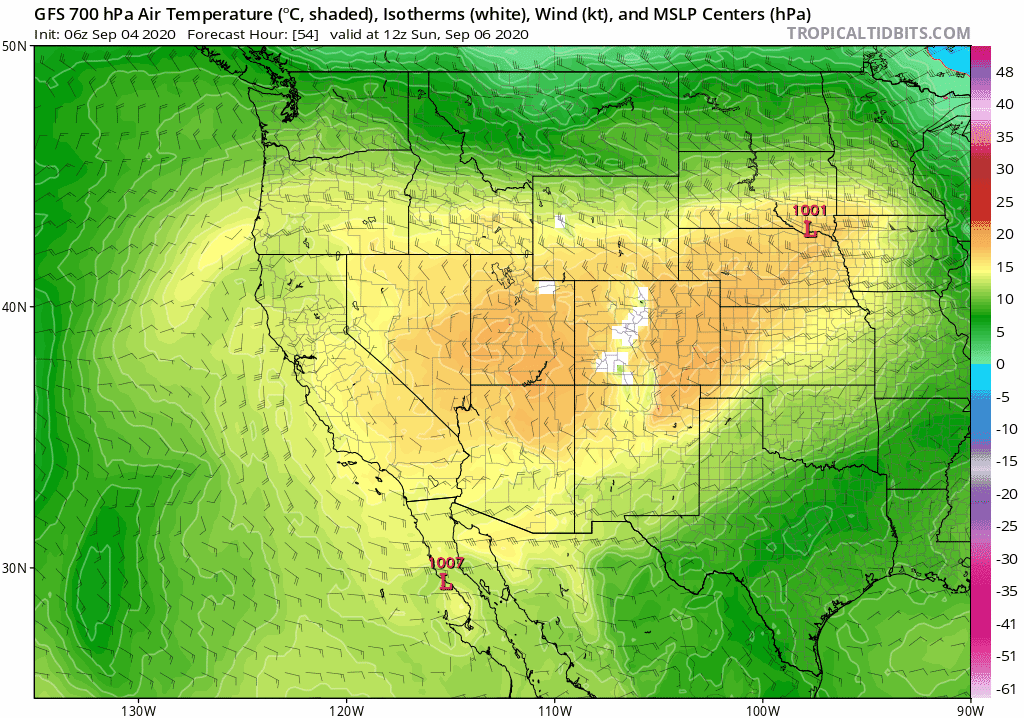
GFS 700mb temperature and wind forecast animation from Sunday into Thursday. The cold air is coming!
The initial drop in temperatures will occur Sunday night. The ridge will begin to break down and disappear to the southwest opening the door for a preliminary cool front to slide southward through the Metro area. Highs Monday will probably be in the 80’s, though recent model trends have been nudging this number downwards. In any case, Monday should be rather pleasant with seasonal temperatures under morning sun and increasing late-day clouds (but no precipitation!). Be sure to enjoy the holiday as it will be the final “summer” day in the near-future.
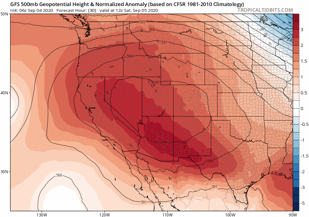
GFS 500mb height anomaly forecast map from Sunday into Thursday of next week. Watch the huge ridge be replaced with a sharp trough in Colorado
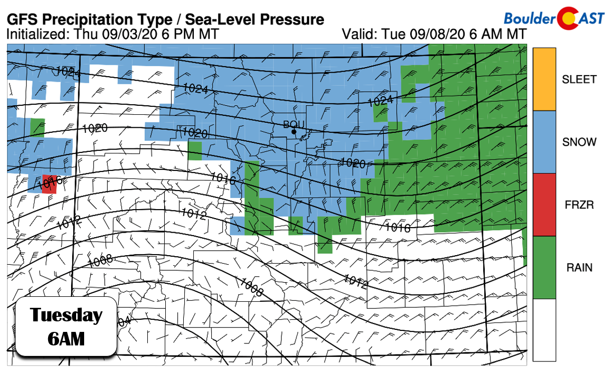
The main cold front is slated to push through Monday night into early Tuesday with temperatures figuratively falling of a cliff. There is still some wiggle for the eventual “bottom out” temperatures, but we could certainly see 30’s through much of the day Tuesday, with possible 20’s Tuesday night. This will of course mean there is indeed the threat of snow across the area. We’re not going to get into the finer details of amount in this update. Those will come later in the holiday weekend when we have a better picture of how this historic storm system will impact the Front Range.
For now, we certainly do expect some snow across the lower elevations with this storm. It will likely begin as rain and change quickly over to snow in the Foothills Tuesday morning. The Plains will be warmer and lag slightly, but the wedge of cold air appears to be lining up just right for early season snow in our area. The 700 mb temperature and wind forecast graphic from the GFS below indicates 30mph northeasterly winds slamming into Colorado’s Front Range. This is the perfect direction and intensity for Boulder and Jefferson Counties.
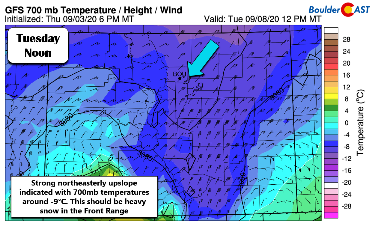
At the same time, temperatures would be cold enough for snow all the way down to the Plains (-9°C at 700 mb). As it stands now, we could see some impressive snowfall rates during the day Tuesday, but what falls versus what sticks is going to be a challenge with this early season system.
How much snow will there be?
First, keep in mind that any falling snow this early in the season would be absolutely historic. For Boulder, if it snows on Tuesday September 8th, this would be the 2nd earliest occurrence of snow. If anything sticks, it would be the earliest ever accumulating snow on record. Anything is possible in our area. Just a few years ago in 2014, we had accumulating snow on September 12th!
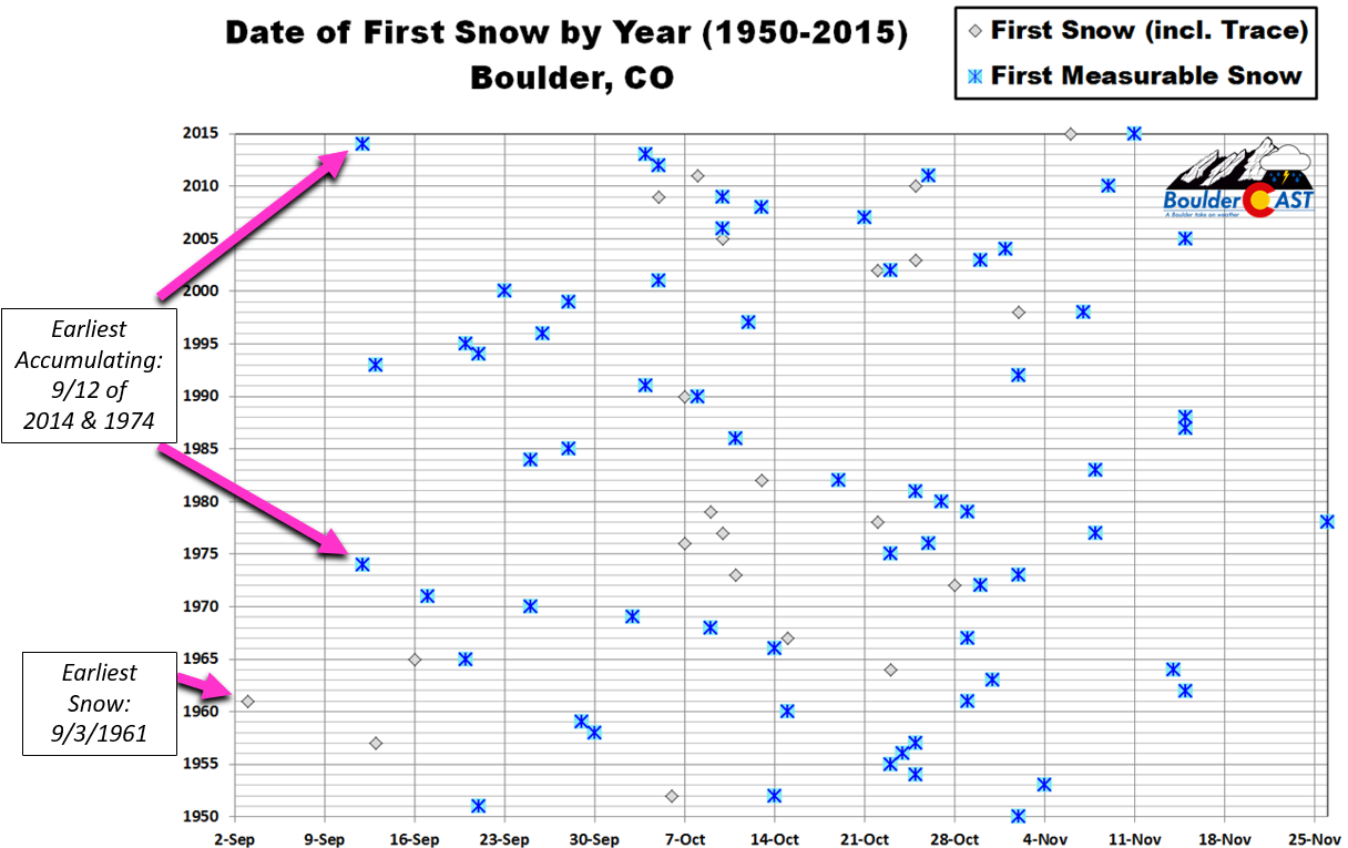
Top 5 Earliest Snows in Boulder:
- Sept 3, 1961: Trace
- Sept 8, 2001: Trace
- Sept 8, 2020: ???
- Sept 11, 1989: 0.7″ (unofficial)
- Sept 12, 1974: 2.7″
- Sept 12, 2014: 0.5″
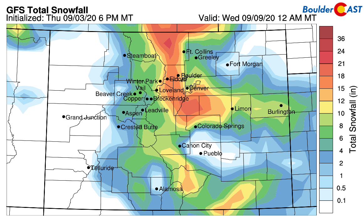
Let’s take a look at a few model projections for snow totals early next week. First, the operational GFS model, shown below. Whoa, is that more than a foot of snow in Boulder and 8-12″ in Denver?! That can’t be right…can it?
To help better grasp the uncertainty in that single GFS run, let’s look at the latest round of GFS ensemble model runs. Firstly, though, we remind you that ensemble runs are from the same exact forecast model, but with slightly different initial states. To run a model, you must feed it the current conditions of the atmosphere…ALL of the atmosphere. And since we don’t have observations of the weather at every single location and at all altitudes, much of the initial input is also “modeled” itself. This can create errors and uncertainty, and one way to gauge this is to change the initial state slightly and re-run the model. The output runs are called “members”. The GFS ensemble has 20 members and each tiny image below is the snowfall output from one of them…..
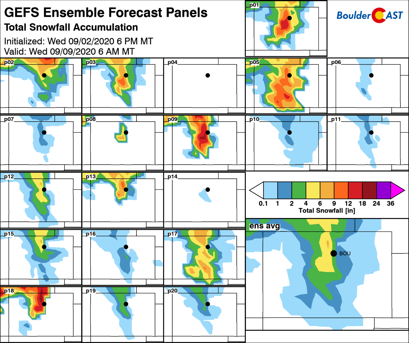
Here is what we see in these ensemble panels:
- Member #1, 2, 3, 5 (20%): A fairly significant early-season dumping of accumulating snow. These runs depict 3 to 10″ for Boulder.
- Member #4, 6, 7, 10, 11, 14, 16 (35%): These runs develop little to no snow across northeast Colorado with a weaker storm with less upslope and only light snow totals in the Mountains and Foothills.
- Member #8, 9, 12, 13, 15, 17, 18, 19, 20 (45%): These runs are in the middle ground, bringing a quick-moving but moderately strong storm to much of Colorado. These runs produce 0-4″ of snow in Boulder. In some cases, there is widespread moderate precipitation, but temperatures remain too warm for much if any snow on the Plains.
We must also keep in mind that ALL of these model projected snowfall totals are significantly inflated. We must hold this potentially strong winter storm in its proper frame…That is, it is still summer! Ground temperatures will be extremely warm and limit anything that sticks to the ground. The ground won’t magically forget it was nearly 100°F Sunday afternoon! Furthermore, the current timing on any snow that occurs is shaping up to be during the day Tuesday with a strong sun supplying additional warming which will help melt things as they fall and stick. Note that an early September sun angle is equivalent in intensity to an early April sun angle. We would need very heavy snowfall rates (2+”/hr) to see any type of significant accumulation during the daylight hours.
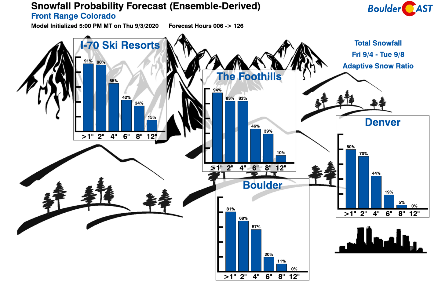
After seeing the ensemble guidance and considering the season we’re in, the outlook for snow in the Front Range is far from certain. There’s definitely a strong case to suggest that everyone will see at least a trace of snow (~65% odds), making this incoming storm one for the record books on that aspect alone. Potential accumulations are going to be much more tricky. It could be anywhere from just few wet, non-accumulating snowflakes to several wet and slushy inches sticking to grassy and elevated surfaces. Feel free to check our Snowfall Probabilities page for the latest odds of various snow amounts from the models (again, these numbers are greatly inflated for Boulder and Denver!).
So in summary….
- Are the scorching near 100°F temperatures going to be replaced with cold weather? Yes. The heat wave will be short and comes to end on Monday, regardless of any model shifts in the coming days. The main cold front plows through with a chip on its shoulder Monday night. Brace for it now!
- Will there be widespread beneficial precipitation in the Front Range and much of eastern Colorado? Most likely, but there is still a small chance this storm could produce very little precipitation for us.
- Is there going to be snow in Denver and Boulder? It’s still not certain, but it’s looking more and more likely with each passing day. We’d put our bets on “yes” as the models have been trending historically colder. Given the state of our foliage, anything more than a few inches of wet snow could be devastating to the area. Right now, we do not foresee any major issues with downed trees as most of the falling snow will melt quickly. This will need to be monitored however as foliage is extensive.
- What about the Foothills? In the higher elevations along the eastern slopes of the Front Range, confidence is very high for accumulating snow, perhaps 6-12″ for elevations above 7000 feet. The upslope is excellent with this storm and temperatures will be in the 20’s up there during the day Tuesday. There will of course be melting to contend with as well, but overall impacts will be greater the higher you go up in elevation.
- What are the possible range of temperatures that might impact the garden, trees, and plants? On the low end, hard-freezes are certainly possible Tuesday evening into Wednesday morning, but this finer detail is still unknown. Play it safe and cover your plants or bring them indoors to protect them from the cold and snow! You have until Monday evening to do this.
- Will there be travel impacts? Probably not. Road surfaces are far too warm that anything that falls should melt. The exception to this will be in the mountain passes above 9,000 feet. If you do have outdoor plans Monday night through Wednesday morning, you may want to consider cancelling.
We’ll leave it at that for now. There will be quite the range of weather to wrap our heads around over the next 120 hours. However, from forecasting weather in the Front Range for more than a decade now, we’ve learned to expect the unexpected. You should too! Be sure to check back for updates, take a peek at our SnowTracker page , subscribe, and follow us on Facebook and Twitter.
Help support our team of Front Range weather bloggers by joining BoulderCAST Premium. We talk Boulder and Denver weather every single day. Sign up now to get access to our daily forecast discussions each morning, complete six-day skiing and hiking forecasts powered by machine learning, first-class access to all our Colorado-centric high-resolution weather graphics, bonus storm updates and much more! Or not, we just appreciate your readership!
.
Subscribe to receive email notifications for BoulderCAST updates:
We respect your privacy. You can unsubscribe at any time.
Spread the word, share this BoulderCAST post:
.


You must be logged in to post a comment.