
Brace for impact! The highly-anticipated early-season storm is confirmed at this point with widespread heavy wet snow expected across the entire Front Range region late Monday night into Tuesday night. We still have our concerns about how much snow will actually stick given the situation. It’s still summer after all! Nonetheless, read on for our in-depth snowfall forecast discussion and map.
PREMIUM WINTER STORM VIDEO UPDATE (10:00 AM Mon 09/07/20): Our early season winter storm remains on-track. We take a look at the latest model runs and discuss the wild weather about to unfold across the Front Range in the next 12 to 48 hours. Click HERE to watch our 40-minute video discussion.
At a Glance:
- Record heat possible again on Sunday, then a slightly cooler Monday but still pleasant
- The dramatic transition to winter begins Monday around sunset with the passage of a strong cold front
- Rain quickly changes to heavy snow by sunrise Tuesday and continues into Tuesday night
- Uncertainty in potential snowfall amounts remains fairly high, but we now have at least some ideas
- Between the record cold and heavy wet snow, impacts will likely be devastating to trees, gardens, crops and fall colors
Help support our team of Front Range weather bloggers by joining BoulderCAST Premium. We talk Boulder and Denver weather every single day. Sign up now to get access to our daily forecast discussions each morning, complete six-day skiing and hiking forecasts powered by machine learning, first-class access to all our Colorado-centric high-resolution weather graphics, bonus storm updates and much more! Or not, we just appreciate your readership!

From the Arctic Circle to Colorado
Since our last major forecast update on Friday, the models have stuck to their guns in regards in the incoming winter storm. We continue to anticipate drastic changes targeting the Front Range behind an unseasonably strong cold front Monday evening. The models have even trended a couple degrees colder in the last few days. Thus, at this point, everyone is guaranteed to see falling snow Tuesday, regardless of your elevation. That is something we are confident about.
As of Sunday morning, the weak trough that will eventually become our snow-maker is located all the way up in central Canada near the Arctic Circle.
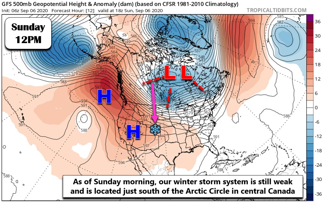
The trough will dive southward into Colorado over the next 48 hours and at the same time intensify into a potent cut-off low pressure system in far southwestern Colorado. This movement and intensification is shown in the animation below.
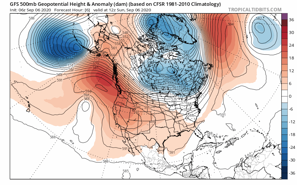
GFS 500mb height anomaly animation from Sunday into Friday showing the developing storm system moving into Colorado
Part of the reason for this storm’s almost due-south bee-line into Colorado from the tundra of northern Canada is the intense ridge that develops over the Alaskan Panhandle on Monday. The ridge is the exact pattern we look for during the winter season to produce significant cold air outbreaks across the United States (e.g. “Polar Vortex” media frenzies), some of which can target the Rocky Mountain State. This amplified ridge pattern in Alaska tends to produce the opposite over the central United States. That is, a big and cold trough. We talked more in-depth about this influential pattern in our recent podcast covering this historic storm.
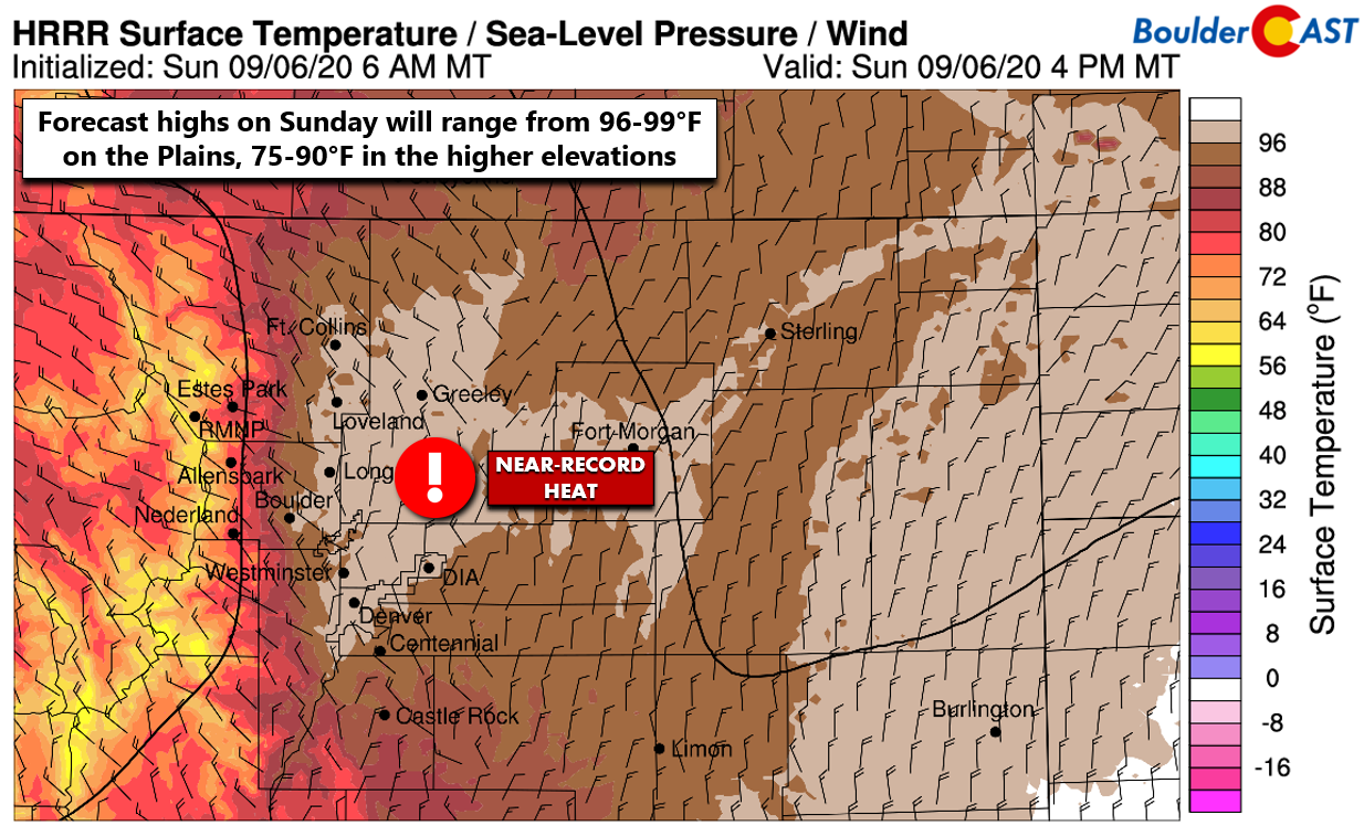
So far this weekend, the forecast has played out just as expected with record heat observed on Saturday across the Front Range. Boulder set a new daily record high temperature at 99°F. Denver set a new MONTHLY record high temperature hitting 101°F. Incredibly, yesterday was the hottest day in Denver during what has already been an exceptionally hot summer of 2020. For the second year in a row, Denver set a new record for the latest triple digit temperature (previous record was September 2, 2019).
Sunday will be another sizzling day in the mid to upper 90’s with numerous record highs popping up and down the Front Range. Gusty winds ahead of our storm system will be present in the High Country and adjacent Plains leading to very high fire danger. This will also be the case on Monday.
A weak cold front will move through Sunday evening making for a slightly cooler day on Monday before the big storm arrives. Monday will be pleasant to wrap-up the holiday weekend with increasing clouds and highs in the upper 80’s to near 90 degrees. Ironically, if Denver hits 90 degrees on Monday, it will tie the all-time record for number of 90-degrees in a calendar year at 73 days.
Rapid changes begin Monday evening
WARNING: You have until roughly 6:00 PM Monday evening to make any necessary preparations for the storm as this is the time when the strong cold front will arrive to the Denver Metro area bringing a swift seasonal transition from summer, to fall, and ultimately winter by early Tuesday morning.
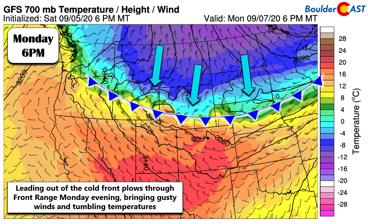
Models are fairly consistent on this timing around sunset Monday evening. However, give yourself some piece of mind and make any preparations earlier. Ultimately the back-end of this storm system will bring a period of sub-freezing temperatures to the area leading to an abrupt and early end to the growing season. This is especially true for areas above 6000 feet elevation.
- Drain all above ground irrigation pipes and valves (no need to fully blow the system out yet)
- Bring potted plants indoors
- Cover gardens and crops, and even consider picking unripened fruits and veggies
Not surprisingly, a winter-like pressure gradient will accompany the front as it blasts southward. Gusty winds of 25 to 40 MPH will be possible within a few hours before and after the frontal passage. Beyond this, temperatures fall quickly from the 80’s late Monday afternoon into the lower 30’s by early Tuesday morning. This is when things get interesting for us….
Snow for everyone!
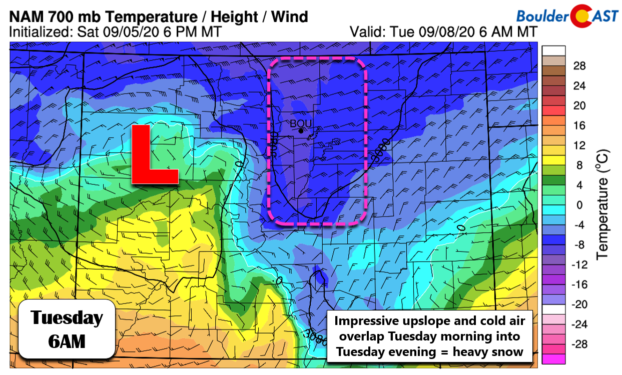
At the same time, concentrated large-scale lift from the trough and the cold front will combine with deep and strong upslope to produce widespread precipitation across our area. There will be a brief period of rain beginning around midnight Monday night. This will transition to snow almost immediately in the Foothills, but it will take several hours to turn-over to snow across the lower elevations. The coldest air arrives just before sunrise Tuesday morning. This will be the final nail in the coffin to change any lingering rain over to snow for everyone across the Front Range. Once we shift to snow, there’s no going back with this very cold system!

The upslope direction shown by the slew of weather models varies between good (northeasterly) and perfect (due easterly) much of the day Tuesday, with speeds of 20 to 35 MPH at 700 mb. This should equate to a fairly prolonged period of moderate to heavy snowfall for the most upslope-favored areas including Boulder, west Arvada, Golden and the entire Foothills region east of the Divide.
These intense snowfall rates are just what the doctor meteorologist ordered to allow for accumulating snow this time of year when it was nearly 100°F just 36 hours prior Sunday afternoon! Even still, predicting actual snowfall accumulation amounts is going to be an enormous challenge with this storm. A quick peek into the historical record shows that there has never been quite this dramatic of temperature swing before the first major snowstorm of the season. We just don’t know exactly what type of snowfall rates will be able to counteract the melt rates due to the very warm ground surface and high early-September sun angle. We talked a great deal about these challenges to accumulation in our last forecast update. We’d certainly be a lot more confident forecasting significant accumulating snow had everything been occurring at night. The daytime nature of the heavy snow with this system makes us even more nervous in the age-old battle between “what falls” versus “what sticks” in this chapter of late-summer snow.
Preliminary snowfall amounts
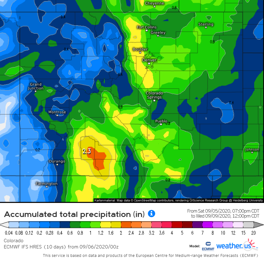
With that said, let’s talk about preliminary snowfall potential. Not considering any of the effects of melting, we need to first pin down exactly how much liquid (rain and melted snow equivalent) this storm is likely to produce. From all evidence, it will dump a lot of moisture across the Front Range. There’s no question about that. This has been ironed out in the models over the last couple days. Upslope-favored areas are well-positioned to see 0.75″ to 1.25″ of liquid. Upper-end model solutions suggest nearly 2″ might on the table. The most likely areas to see this much moisture would be the Foothills of Larimer, Boulder, and Jefferson Counties, as well as the city of Boulder. Either way, this will be our most beneficial moisture dump since late May.
Models are in fairly good agreement for these liquid amounts. Here’s the European model solution below. Around 1″ for most of the Metro area, with closer to 1.5″ in the Foothills.
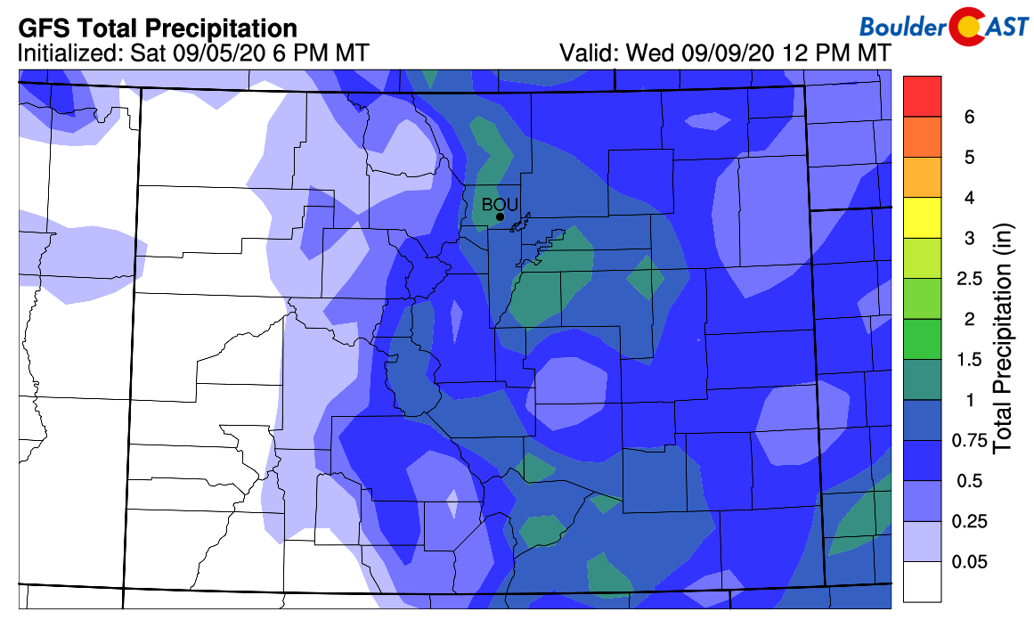
Here’s the American GFS solution below. Generally 0.75″ to 1.25″ everywhere. The GFS ensembles, while well-clustered, are towards the lower-end of that spectrum.
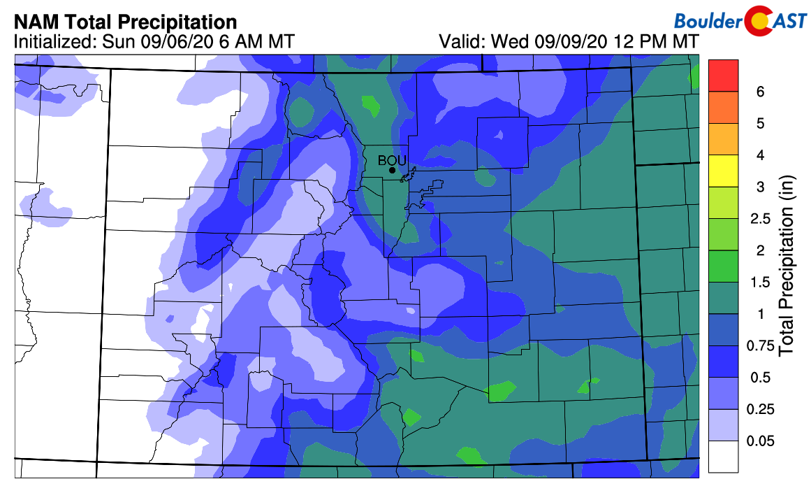
And finally, here’s the solution from the NAM model. 0.75″ for the bulk of the Metro area, with over 1″ in the western suburbs and Foothills.
With confidence fairly high in the liquid potential, we can begin to formulate a forecast for snowfall amounts in this very atypical mashup of summer and winter. Here are some of the assumptions with this snowstorm that factor into potential amounts:
- Some moisture will be “lost” to rain near the onset of the precipitation across the lower elevations Monday night. This amount could be as high as 25% or so. A relatively quick change-over is expected however before sunrise Tuesday morning.
- Heavy snowfall rates due to efficient upslope will overpower melting to allow accumulation on grassy surfaces and trees. Little to no snow will stick on any pavement surfaces.
- Elevation will be a factor, with low-lying areas staying warmer and experiencing more melting. This means Longmont to Greeley will have less snow stick.
- Temperatures will be much colder in the Foothills Tuesday (20’s) so this will favor more accumulation there. Snowfall rates will be intense there as well.
Our final snowfall forecast map for the event is shown below. This covers snow falling from Monday night into mid-day Wednesday. The ranges we have chosen are broader than normal, mainly due to how much uncertainty there is with regards to melting and near-freezing temperatures during this extraordinarily early snow event. Remember that what you see on the ground at the end of the event may be significantly less than these amounts (i.e. snow depth vs. snow accumulation). However, all systems are a go for an early-season winter wonderland…or at least a “slushy” wonderland!

There is still a few model differences on what happens to the cut-off low pressure on Wednesday. It might linger to our southwest a little longer, with lighter snow (possibly mixing back to rain on the Plains) lingering across the region. For now, we think most of the accumulating snow will come to an end by sunrise Wednesday. We’ll revisit this extended outlook at a later time.
Impacts
- Lower Elevations: Heavy wet snow may cause significant tree damage and power outages, particularly in the western suburbs and Boulder where up to 8″ of snow could accumulate onto fully leafed-out trees. Roadways should remain largely just wet, except in the absolute heaviest bursts of snow where some slush will be possible Tuesday morning and afternoon. Temperatures will remain right around freezing during the day Tuesday, then fall into the mid to upper 20’s Tuesday night. These sub-freezing temperatures will bring an end to the growing season in most areas and obliterate existing record low temperatures for the date. As mentioned earlier, make the necessary preparations with any outdoor plants or animals/livestock. The lasting impacts on our vegetation may not fully be realized until next spring.
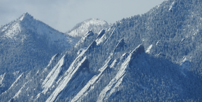
- Foothills & Mountains: 7 to 15″ of snow in the higher elevations will be devastating to leafed trees and may cause power outages. Fortunately most of the trees in these locations are of course evergreens. Temperatures plummet into the 20’s during the day Tuesday and into the teens Tuesday night. The aspen trees are certainly going to be impacted with limited or no fall color display due to the rock-hard freeze.
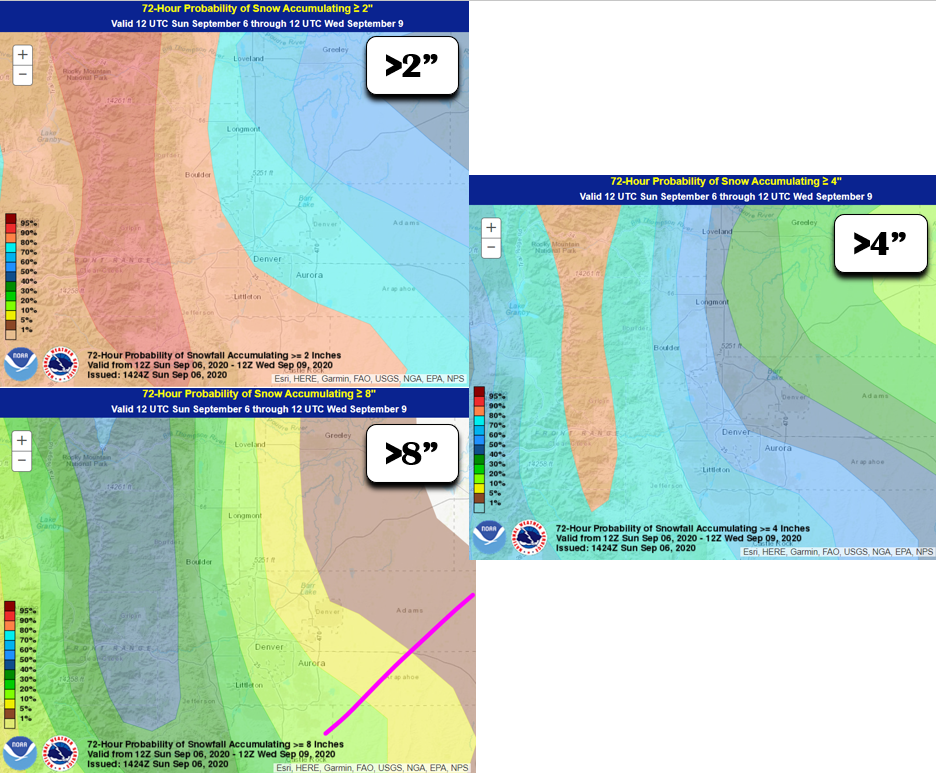
Snowfall exceedance probabilities from the Weather Prediction Center (WPC). In our opinion, like most model outputs, these values are inflated considerably for the lower elevations
Final remarks
Despite the uncertainty in what ultimately sticks, this is an unprecedented and extraordinary early season winter storm. Brace for impact and take the necessary precautions. It is definitely going to snow and it will be about 70 degrees colder on Tuesday compared to Sunday!
Be sure to check back for updates, take a peek at our SnowTracker page , subscribe, and/or follow us on Facebook and Twitter.
We were ready for the brutally hot summer to end, but we certainly were not ready for this!

Help support our team of Front Range weather bloggers by joining BoulderCAST Premium. We talk Boulder and Denver weather every single day. Sign up now to get access to our daily forecast discussions each morning, complete six-day skiing and hiking forecasts powered by machine learning, first-class access to all our Colorado-centric high-resolution weather graphics, bonus storm updates and much more! Or not, we just appreciate your readership!
.
Subscribe to receive email notifications for BoulderCAST updates:
We respect your privacy. You can unsubscribe at any time.
Spread the word, share this BoulderCAST post:
.


You must be logged in to post a comment.