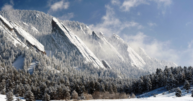
This past winter was an under-performer in many regards. From the record-breaking late-start to the snow season, to the rain storms of March and April, it was NOT great year for powder across the lower elevations! Continue reading as we review a season of disappointment and crunch the numbers to see how well our snowfall forecasts verified throughout the Denver Metro area across the entire winter season.
A lackluster year for snow
In Boulder, our five biggest snow storms this year were 14 inches, 9 inches, and 8 inches three times. Compared to the count of four 15+ inchers last year, this winter’s lackluster showing of snow was a BIG disappointment. Boulder’s official seasonal total reached only 62″ this winter, about two feet below normal. Denver made out much worse, only measuring 22″, their second lowest seasonal snowfall total on record.
The main reason for these lower overall snow totals was TEMPERATURE:
- Near-record warmth dominated the months of October, November, February, and March. Mean temperatures during these months were some five to eight degrees above normal!
- Denver and Boulder reached the 80-degree mark during the months of November and February for the first times ever (climate change is cool, right?).
- Because of this, temperatures were a much tougher forecast this year, turning at least four potential snowstorms into rainstorms for Boulder during the months of March and April (here’s one, and another).
- There were also two freezing drizzle events in late January and early February….which of course, weren’t snow either! We explained how rare these events are.
- We even broke our streak of White Christmases and had our latest ever appearance of snow (November 17th). The latter put a bit of a wrinkle in our “First Snow” Contest.
It’s actually somewhat of a surprise we were even able to reach 62″ amidst this poor of atmospheric cooperation. Temperatures usually aren’t this big of an issue during La Niña winters, though officially denoting this past winter a La Niña is a bit of a stretch. It died before 2017 was even a month old.
Despite the warm temperatures, precipitation has remained steady and has trended wetter these last few months. While snowfall on the Plains is fun to keep track of, it usually melts so rapidly that it has little hydrological impact for the region. Rain? Snow? It really doesn’t matter for the lower elevations. Drought has been eliminated from Colorado and our snowpack is now at 150% of normal, which are the most important outcomes of Winter 2016-2017. The mountain snow will continue to melt well into July and slow-feed the lower elevations water that we desperately need. I’d say we made out alright, no…better than alright, this year!
How did our snowfall forecasts turn out in your location?
Below we verify our forecasts for a winter’s worth of snowstorms! There were a total of 13 different events for which we issued “official” snowfall forecasts, spanning a time period more than six months from November 17th to May 19th. Almost all of these “final” forecasts were issued at least 12 hours before any flakes started flying. Some were posted more than one day in advance.
We have included a fairly comprehensive list of 19 locations spread over 8 counties across the northern Denver Metro area, including some of the smaller towns in the Foothills.
We gave a “Yay” or “Nay” as a correct forecast for each of the 13 events at each location. To be labeled as a correct forecast, the observed snow total needed to be within 1″ of our given forecast range. If it was outside that “buffer inch”, we deemed that forecast incorrect.
Results for each location are below, first in table form, then in map form:
| City | % Correct | # Under-forecasted | # Over-forecasted |
|---|---|---|---|
| Allenspark | 77% | 1 | 2 |
| Arvada | 69% | 2 | 2 |
| Aurora | 92% | 1 | 0 |
| Berthoud | 100% | 0 | 0 |
| Boulder | 62% | 4 | 1 |
| Broomfield | 77% | 3 | 0 |
| Denver (DIA) | 92% | 1 | 0 |
| Denver (downtown) | 92% | 1 | 0 |
| Erie | 85% | 2 | 0 |
| Estes Park | 77% | 0 | 3 |
| Genesee | 62% | 2 | 3 |
| Golden | 46% | 5 | 2 |
| Jamestown | 85% | 0 | 2 |
| Lakewood | 62% | 2 | 3 |
| Longmont | 100% | 0 | 0 |
| Lyons | 85% | 1 | 1 |
| Nederland | 85% | 1 | 1 |
| Niwot | 100% | 0 | 0 |
| Superior/Louisville | 77% | 2 | 1 |
.
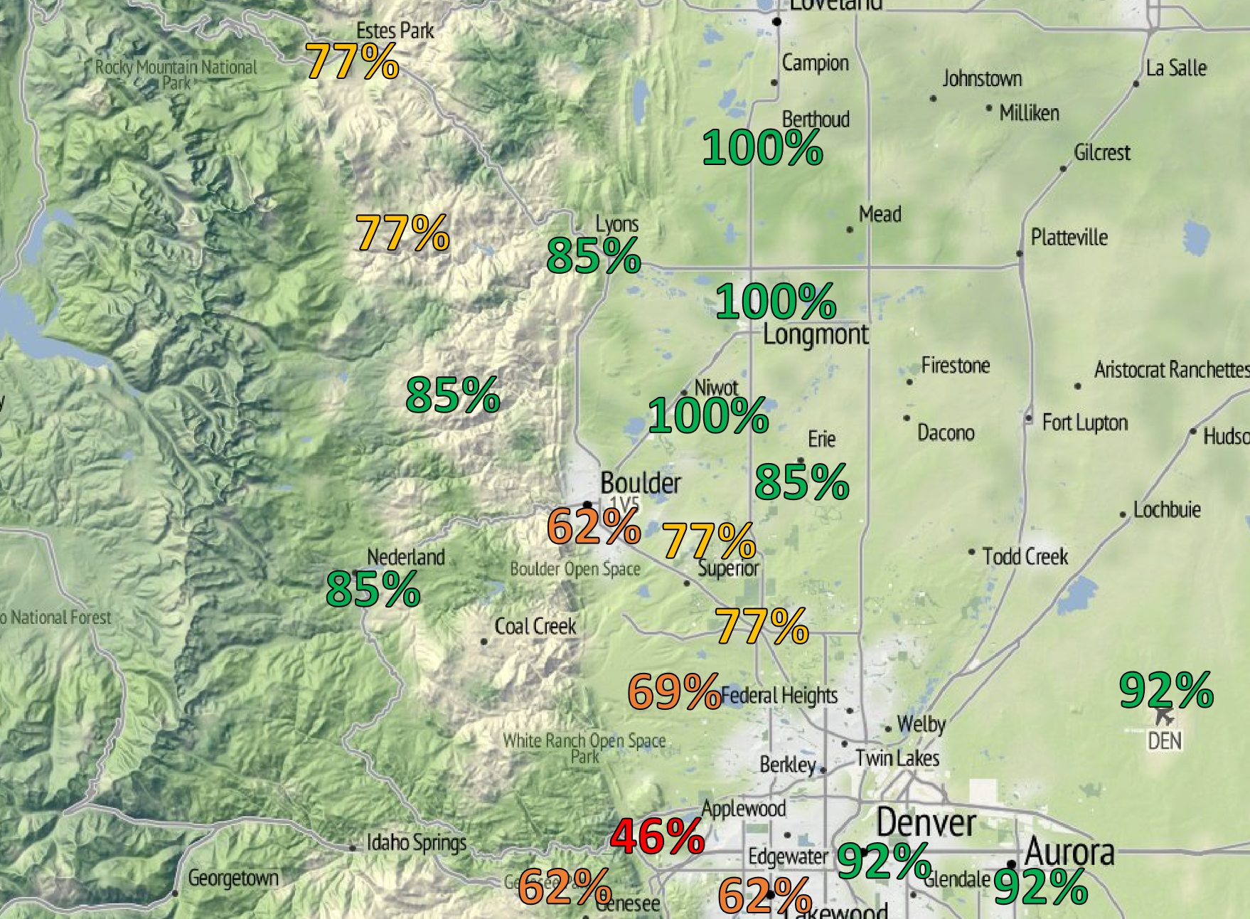
Percent “correctness” of our snowfall forecasts for Winter 2016-2017.
Yikes…we were only correct for the city of Boulder 62% of the time this winter (8 out of 13 storms). Some of our shortcomings were:
- Mid-January over-producer: A weak system that tracked well to our south produced slightly more snow than expected to the region. Our forecast of <2″ did not match up with Boulder’s total of 4.0″.
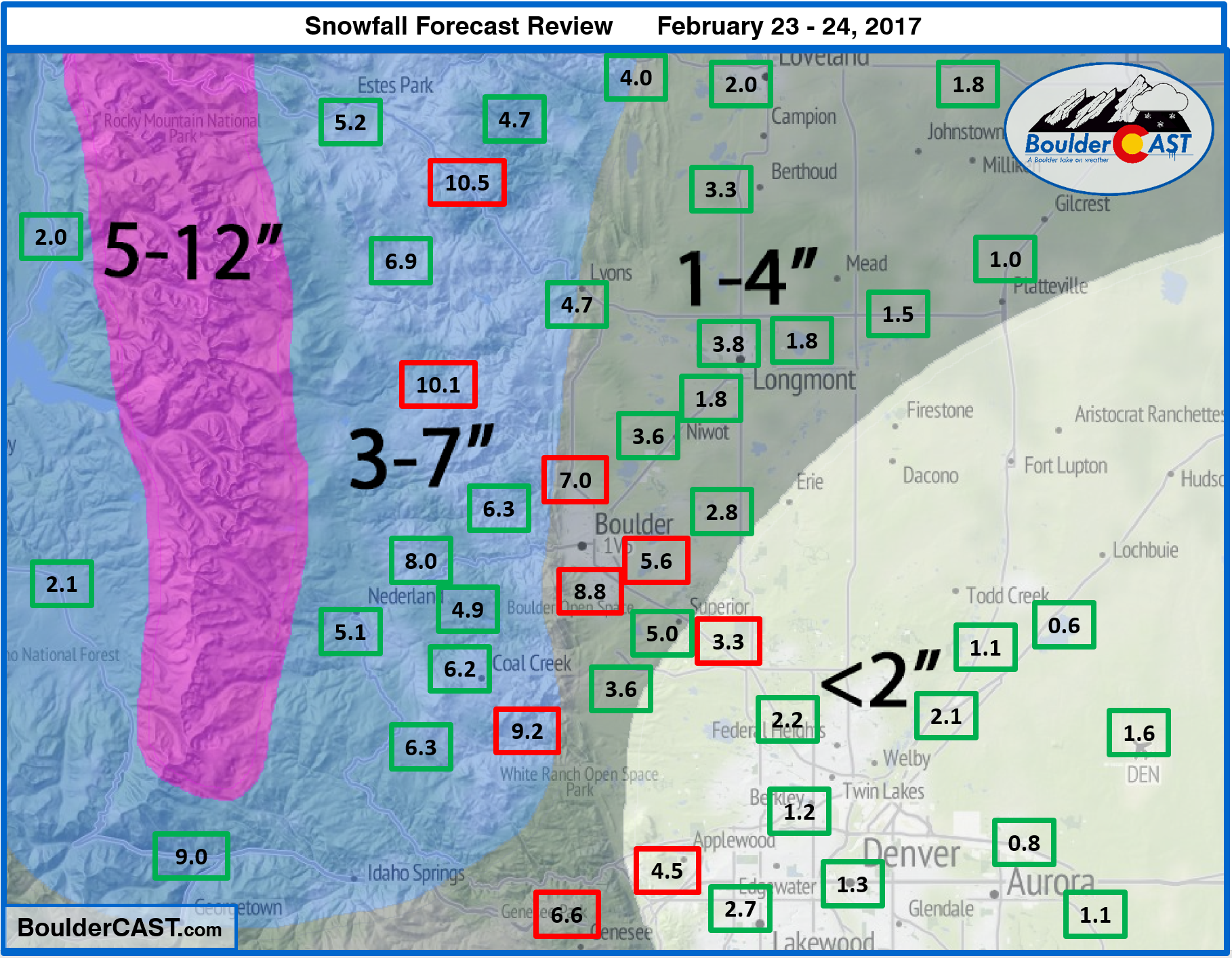
- February 23-24: A snow event defined nearly entirely by its upslope. Large-scale forcing was nearly non-existent. We weren’t impressed with the model’s depiction of the upslope, and opted for 1-4″ in Boulder. Nearly 9″ fell in Boulder (the most out of the entire Front Range, including the higher elevations). The upslope ended up remaining just strong enough and a perfect northeast direction to produce persistent snow in Boulder for many hours. Denver recorded just 1″ from this one.
- April Fools Rain: This storm was the third in 10 days that *could* produce snow across the lower elevations. It was the coldest, but unfortunately, was just a single degree too warm to turn the rain to snow. Our forecast of 2-5″ in Boulder was disgraced by the 0″ that was officially reported…
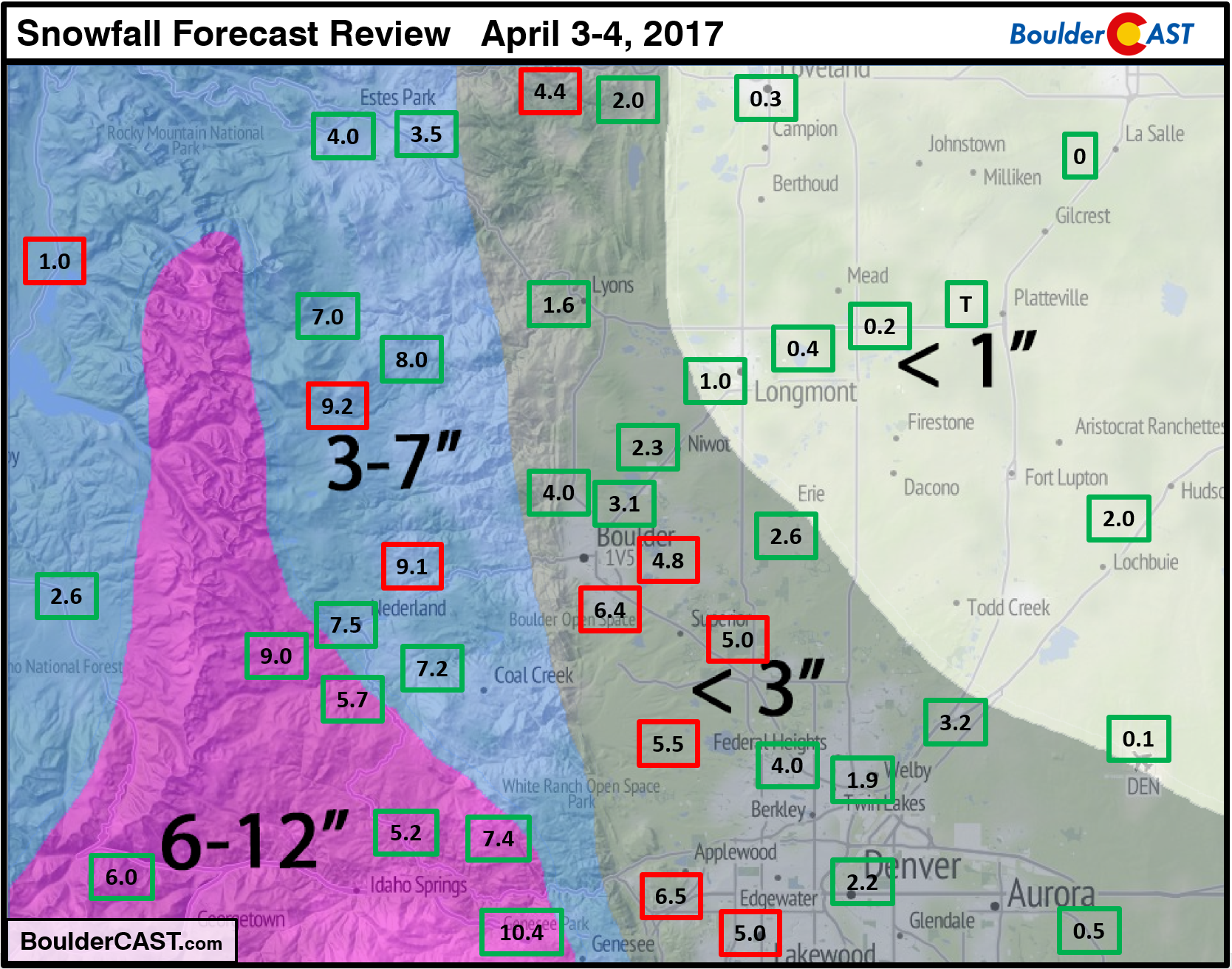
- April 3-4: This storm that occurred just two days later than the prior was plenty cold for snow. However, our forecast of up to 3″ didn’t cover the observed 7″ in Boulder. The models did not have a good grasp on this storm as there was even a secondary wave of snow late in the day on April 4th that occurred almost out of the blue. This snow produced an additional 4″, for a “storm total” of 11″.
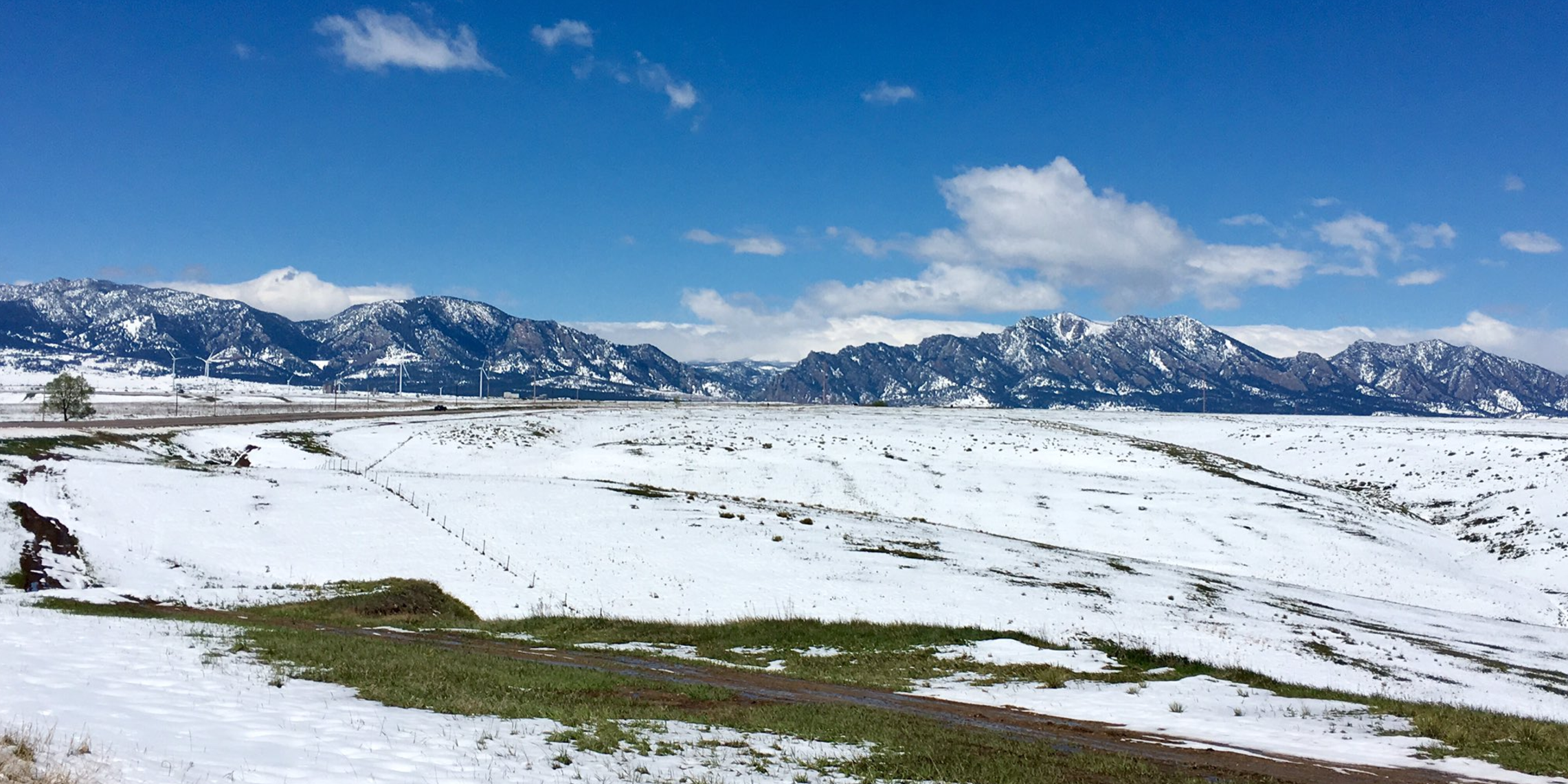
May sun melting the snow | May 20, 2017 | Photo credit: Julie Fisher
Looking at the results from around the rest of the Denver Metro area, we tend to be correct 75-95% of the time. We’re particularly proud of being PERFECT this winter in Longmont, Berthoud, and Niwot. Though admittedly, Longmont for example, only accumulated more than 4″ from a storm one time this winter. “Less than 3 inches” is almost a flawless forecast for any storm in northeast Boulder County. On another positive note, we nailed the two biggest storms of the year, which is always nice: Boulder’s 14-inch storm in early January and the monster that dropped over 40″ in the Foothills west of Boulder just two weeks ago.
Overall, we’re happy with our results across the region this winter. We guarantee you won’t be able to find another weather outlet with a better track record in Boulder (and much of the Denver Metro). Of all the populated locations across the Front Range, Boulder is definitely one of the most unpredictable, especially when forecasting snowfall.
Want more specifics for your location? Check out THIS spreadsheet for all the gory details for every storm at each location and a conglomeration of all the statistics. Furthermore, we have included links to all of our wintry forecasts and recaps below, as well as a quick-look photo for a visualization of how each storm turned out across the Front Range.
Thanks for toughing the winter out with us!
While the weather across the Front Range tends to quiet down as we head into summer, the BoulderCAST team will continue to make even the most mundane of weather interesting for you all. Expect continued weekly outlooks, random informative posts, and check-ups on monsoon season and the developing El Nino as the summer progresses. During these quieter months, we’ll perform annual site maintenance/upgrades, release new forecast products and improve upon existing ones. Yes, exciting times lie ahead. Thanks for reading!
P.S. We’ll be posting the results of the Late Season Snow Contest in the next few days.
North Broadway, February 2, 2016
2016-2017 Storm Summaries (reverse chronological order)
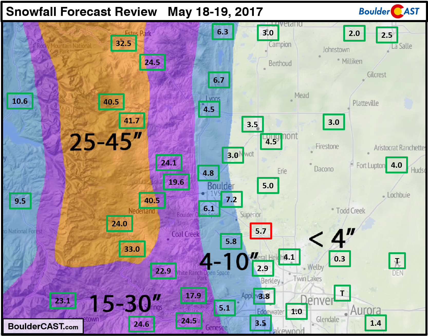
May 18-19, 2017
Boulder: 6.1″ (4-8″ forecast)
Denver: Trace (< 4″ forecast)
Storm Forecast / Recap
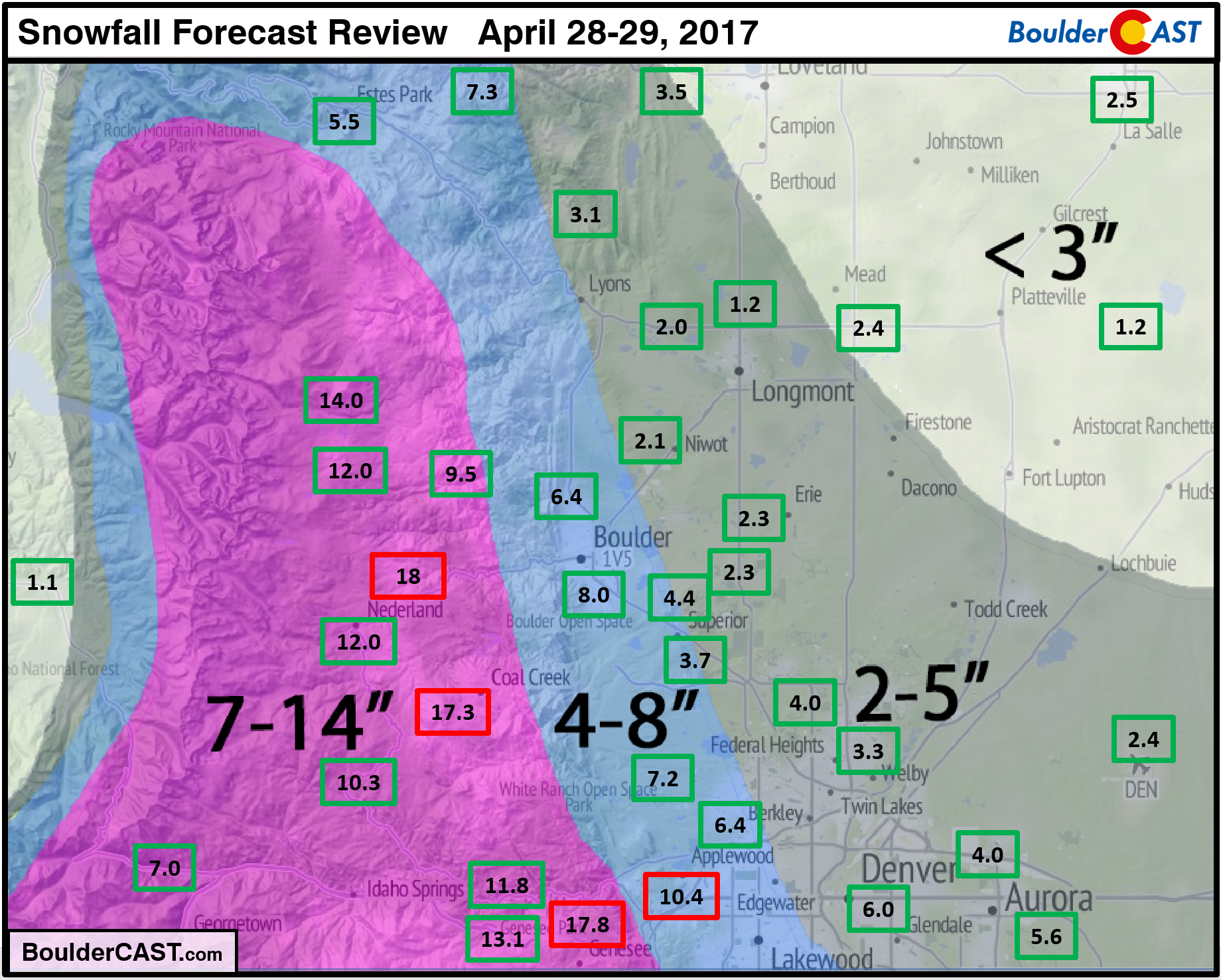
April 28-29, 2017
Boulder: 7.8″ (4-8″ forecast)
Denver: 2.4″ (2-5″ forecast)
Storm Forecast / Recap
April 3-4, 2017
Boulder: 6.7″ (< 3″ forecast)
Denver: 0.1″ (< 1″ forecast)
Storm Forecast / Recap
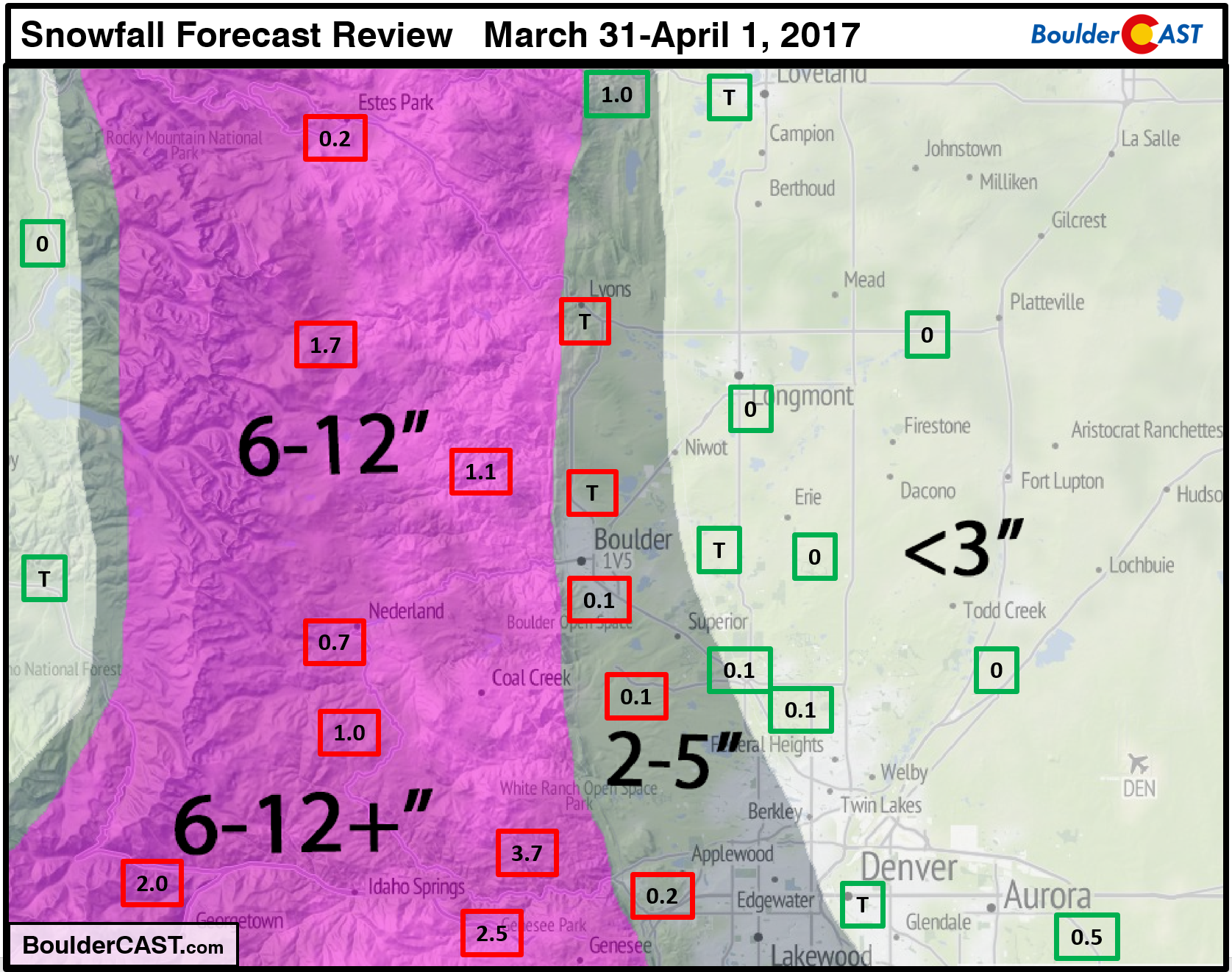
March 31-April 1, 2017
Boulder: Trace (2-5″ forecast)
Denver: Trace (< 3″ forecast)
Storm Forecast / Recap
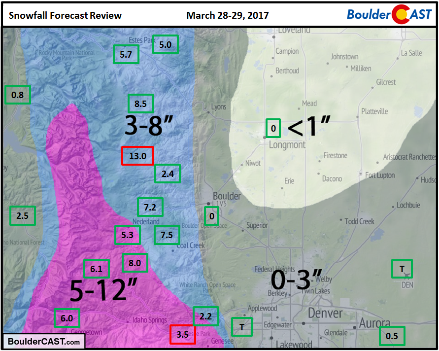
March 28-29, 2017
Boulder: None (< 3″ forecast)
Denver: Trace (< 3″ forecast)
Storm Forecast / Recap
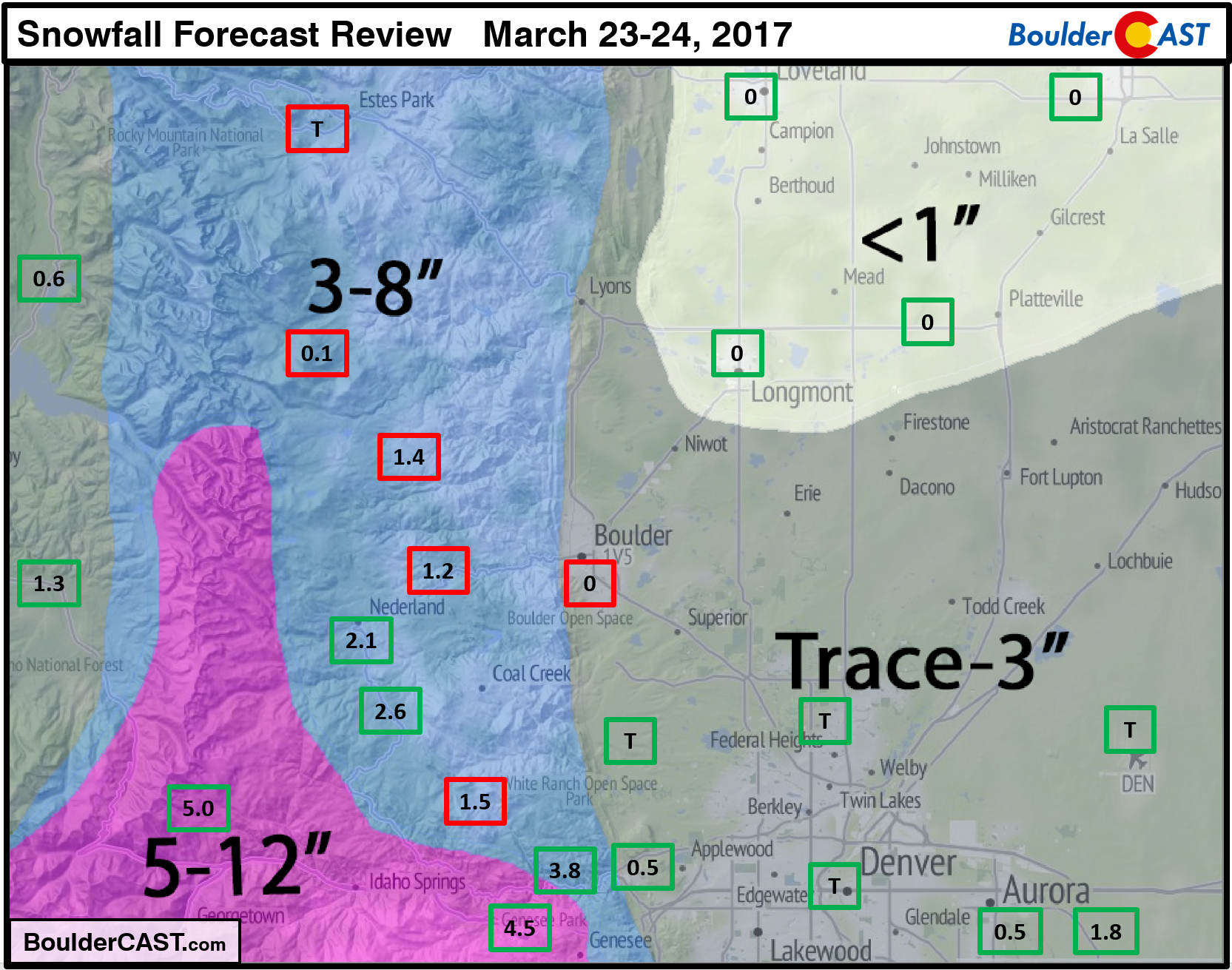
March 23-24, 2017
Boulder: None (< 3″ forecast)
Denver: Trace (< 1″ forecast)
Storm Forecast / Recap
February 23-24, 2017
Boulder: 8.8″ (1-4″ forecast)
Denver: 1.6″ (<2″ forecast)
Storm Forecast / Recap
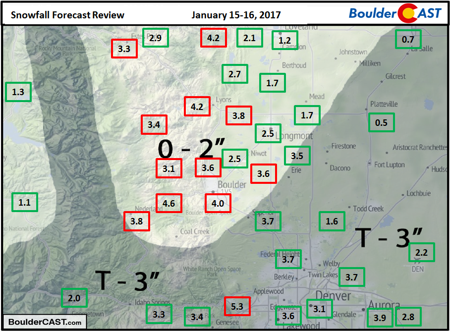
January 15-16, 2017
Boulder: 4.0″ (0-2″ forecast)
Denver: 2.2″ (Trace-3″ forecast)
Storm Forecast / Recap
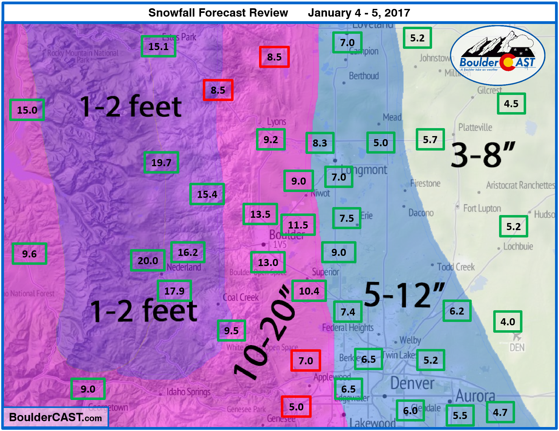
January 4-5, 2017
Boulder: 13.8″ (10-20″ forecast)
Denver: 4.1″ (3-8″ forecast)
Storm Forecast / Recap
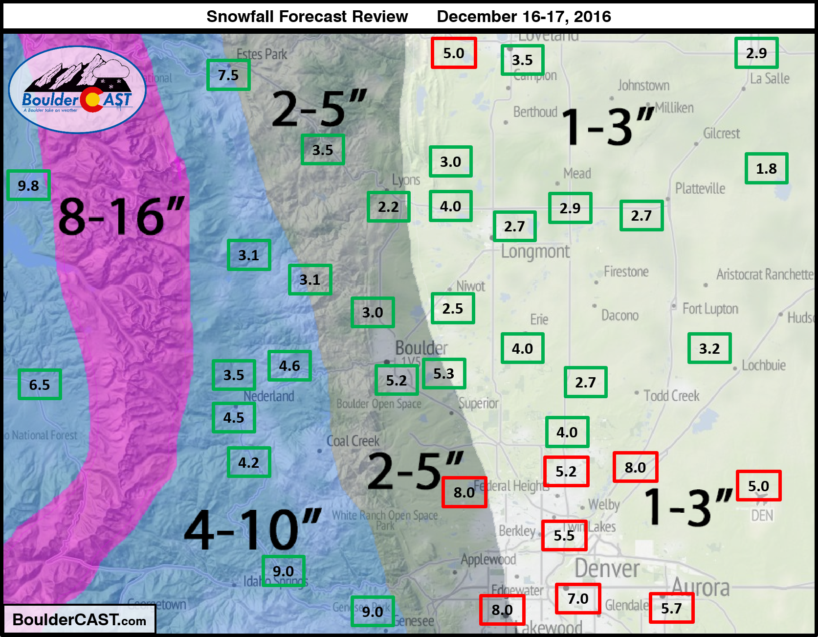
December 16-17, 2016
Boulder: 5.2 (2-5″ forecast)
Denver: 5.0″ (1-3″ forecast)
Storm Forecast / Recap
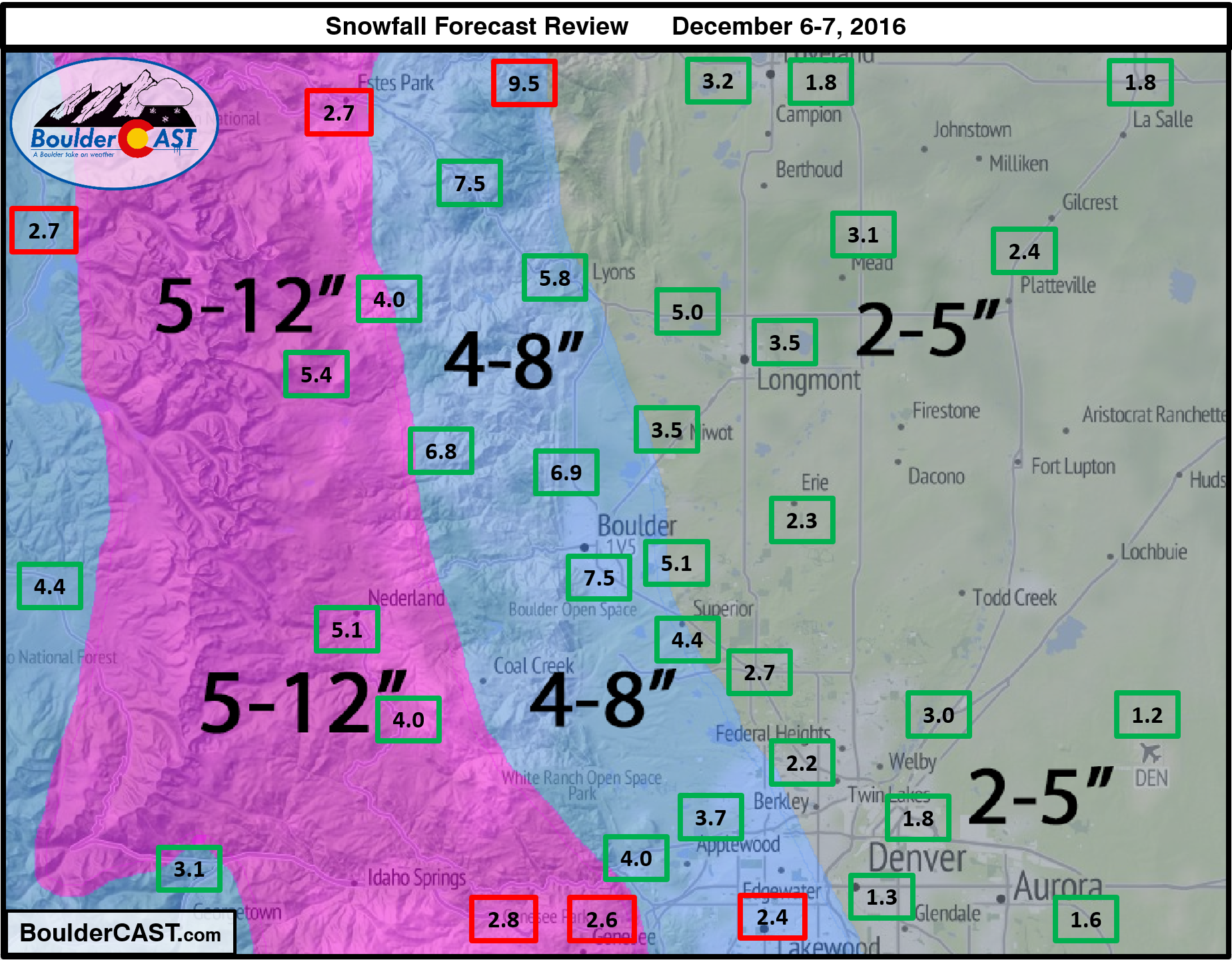
December 6-7, 2016
Boulder: 7.5 (4-8″ forecast)
Denver: 1.3″ (2-5″ forecast)
Storm Forecast / Recap
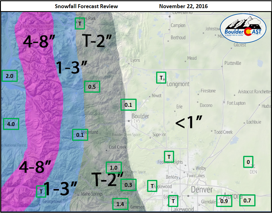
November 21-22, 2016
Boulder: None (Less than 1″ forecast)
Denver: None (Less than 1″ forecast)
Storm Forecast
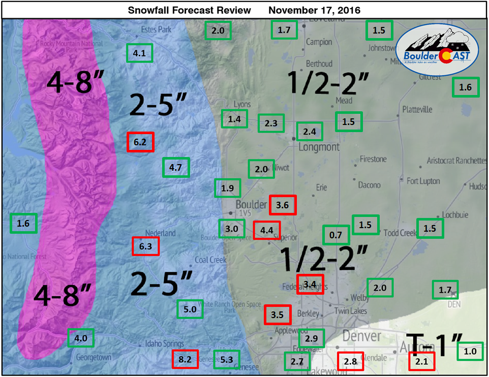
November 17, 2016
Boulder: 4.4″ (1/2-2″ forecast)
Denver: 1.7″ (1/2-2″ forecast)
Storm Forecast / Recap


You must be logged in to post a comment.