Thanks to a stationary band of heavy snow Friday night, many of you may have awoken to more snow than expected. We explain what happened overnight to produce 5-10″ of snow in parts of the Denver Metro area and also detail when we expect the Arctic chill to retreat.
Here’s the totals:
Our final forecast called for 1-5″ across most of the Plains, with 4-10″ in the Foothills. Snow initiated just after sunset Friday evening and persisted less than 12 hours into early Saturday morning. Snow was falling, heavy at times, when surface temperatures were near zero degrees in many locations. Appreciable snowfall alongside air that cold is quite a rarity!
Shown below is our original forecast map created Thursday evening. The observed storm totals per location are contained in boxes. Green ones indicate that the observed snowfall was within one inch of the given forecast range, while red was outside the scope of our forecast.
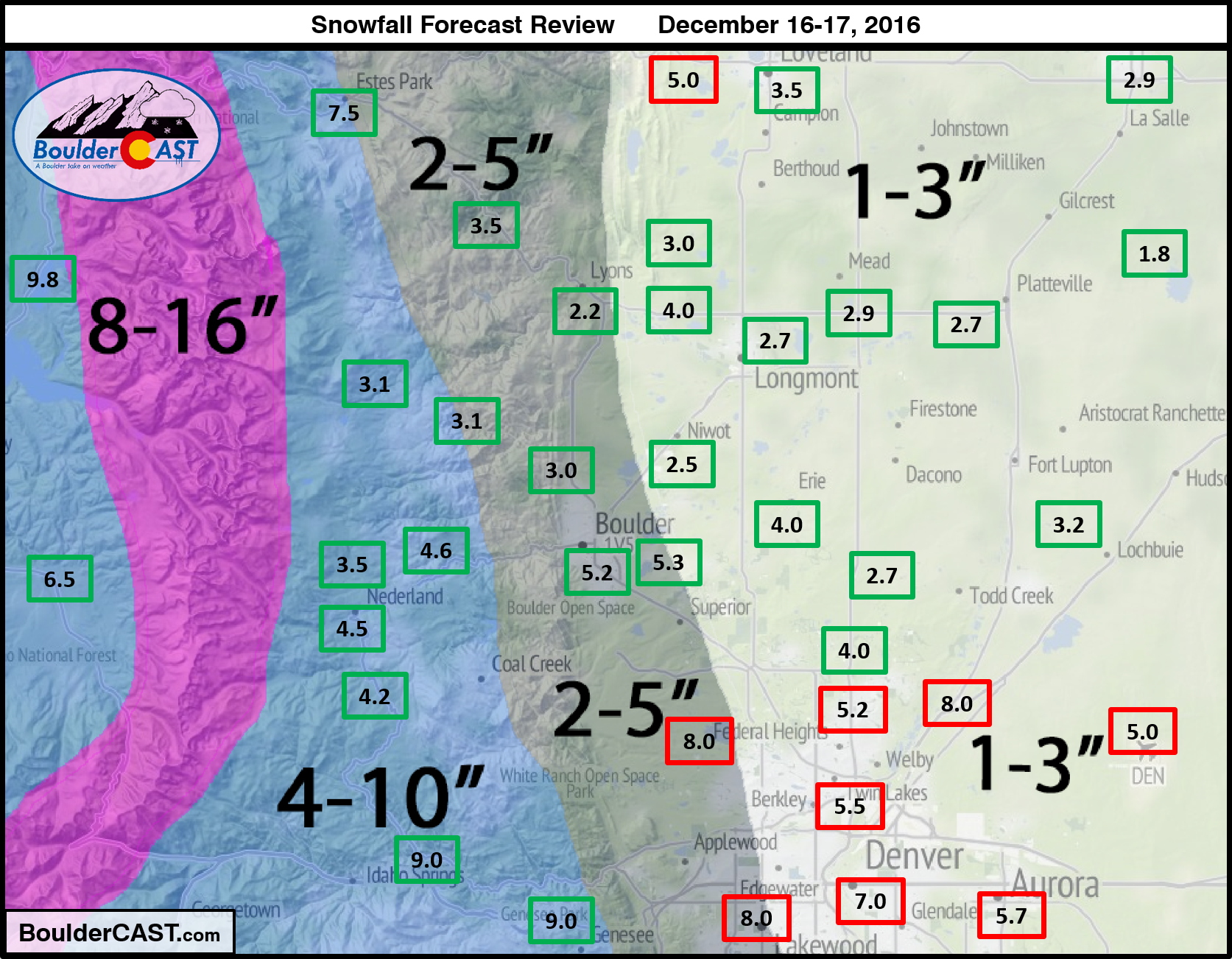
From the large cluster of red across Denver, it’s easy to see just how big of an impact that snow band had. Totals in Denver ranged from 5-10″, with Denver’s official measurement from DIA coming in on the low end (as usual).
Boulder mostly missed out on the heavier snow, except a few intermittent bursts early on in the event. Even so, Boulder’s official total was 5.2″. There was a north-south gradient in city itself (as opposed to the normal east-west gradient), with less snow north (further from band) and more south (occasionally within the edge of the band). We measured just 3.0″ at BoulderCAST Station in North Boulder.
Outside of Denver, our forecast verified quite well, though, totals were generally near the peak of our ranges (yay snow!).
See our updated 2016-2017 Winter Storm Summary page.
So what happened?
In our final forecast for the storm, we discussed how similar it looked on paper to the one ten days ago, with two notable differences:
- Models and their ensembles were predicting less liquid overall
- Jet dynamics looked better with this second system
Unfortunately, #1 and #2 have opposing impacts on snowfall totals. We expected that the liquid shortcoming indicated by the models would be boosted a bit by a few jet-induced snow bands, and predicted more-or-less the same amount of snow as we did for the December 6th-7th storm. Clearly the jet dynamics should have been weighted more heavily in our forecast this time around….
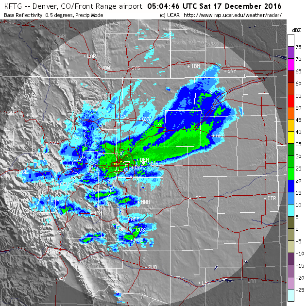
Jet-forced heavy snow bands are always a tough battle. At their core, they can produce snowfall rates FOUR to EIGHT times greater than shallow upslope can sustain by itself. Based solely on this, you can imagine how they can be an “X-Factor” for any storm. Last night was a great example of this! One such band formed and continued to redevelop over much of Denver proper from 9PM to 3AM, stretching east from Golden to DIA . Watch the full radar loop below (click it if it doesn’t load properly).
Radar animation from Friday night, showing the heavy band draped across Denver and extending northeast beyond DIA.
Mid-range operational models (like the GFS and ECWWF) can’t resolve the small-scale structure required to accurately predict these bands. Up until a few hours before the storm, when the hi-res models come into play, the best we can do is forecast a general region for the bands and how likely/widespread they may be. We “boxed” northeast Colorado as a likely spot for jet forcing (see below) in our forecast posted more than 24 hours before the storm arrived.
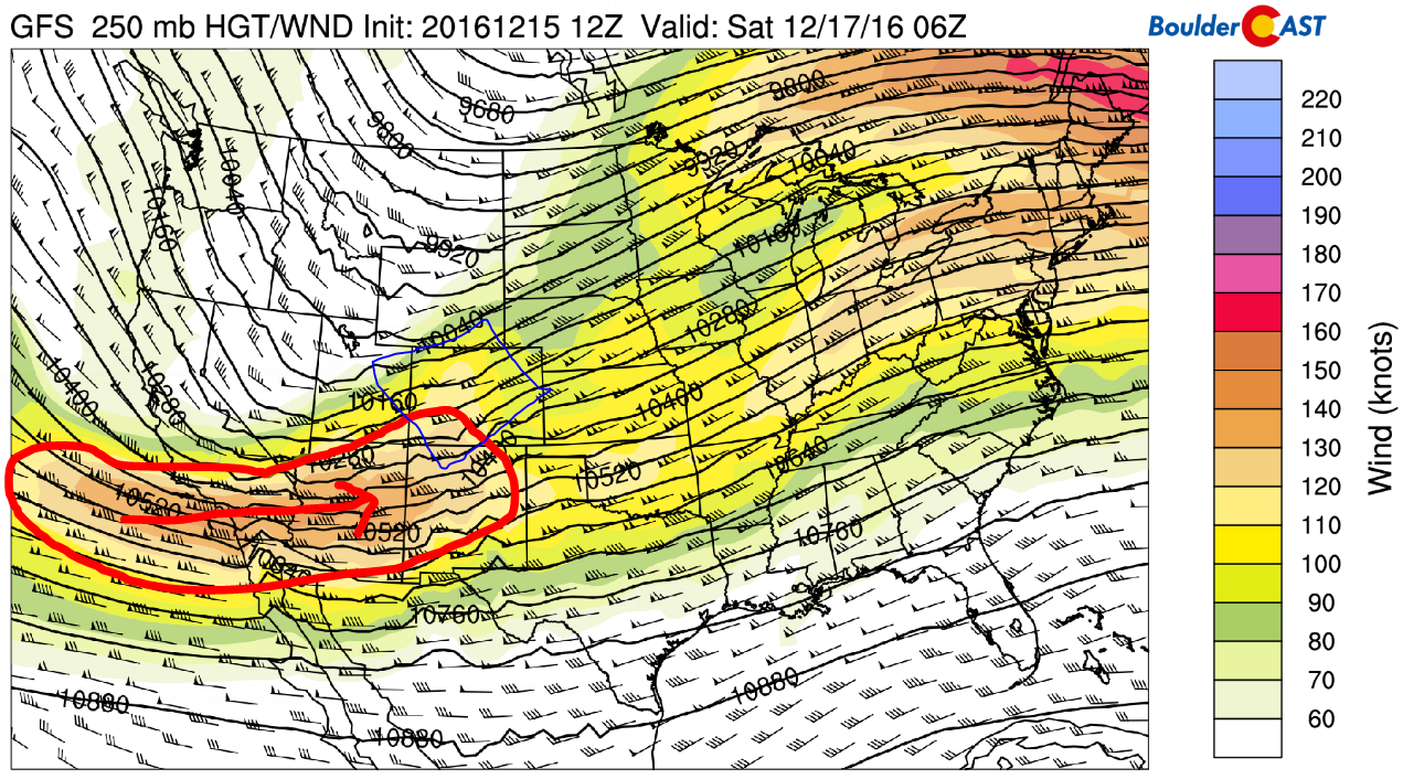
GFS 250 mb height and wind map showing a potent jet streak at the base of the trough (circled in red) and a favorable region for jet-forced snow across Colorado.
Last night, the bands were more numerous and stationary than expected. The high-resolution HRRR model runs Friday afternoon showed plenty of heavy bands over the region, something that concerned us our forecast may be too low.
With three to six inches already on the ground, the National Weather Service issued a Winter Weather Advisory around 10PM, and later, a Winter Storm Warning for the Denver Metro area. Better late than never, right? Denver International Airport saw much more snow than they planned for, causing major travel delays.
All-in-all, Denver received the most snow out of the entire western Great Plains region, including parts of Wyoming, Nebraska, and South Dakota, where the actual surface low was expected to dump 6-12″. The lesson here: don’t ever forget, the jet stream can truly be a game changer!
Looking ahead to warmer times
After a high barely above zero on Saturday, temperatures will plummet Saturday night to dangerous, potentially record levels. Most locations should land between -5 and -15 degrees Sunday morning!
Temperatures will moderate nicely as we begin the week, into the 20’s Sunday, the 40’s Monday, and possibly 50’s by Tuesday. Our next chance at snow comes during the day or two leading up to Christmas. More on that in our weekly outlook Monday…


You must be logged in to post a comment.