Hot of the heels of our December outlook calling for a much-needed change in our weather pattern, the first snow-maker of the month arrives tomorrow as a quick-moving system skirts Colorado from the northwest. In our final forecast, we detail the specifics on timing, intensity, and how much snow to expect alongside our first sub-zero temperatures in almost two years.
We covered the storm earlier today in greater depth within our weekly outlook. In this post, we summarize the important points and largely confirm our thoughts stated earlier. We’re seeing fairly good consistency in the models for tomorrow’s snow event. In fact, much more than we get for most Front Range snow storms!
General Set-up:
The atmospheric set-up is a classic La Niña snow scenario for the Front Range…a relatively quick-moving low sweeping across Colorado from the northwest in collusion with a surface Arctic high in the northern Rockies/Great Plains.
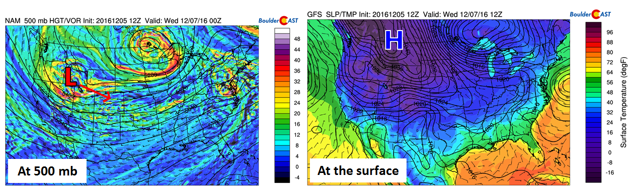
Storm setup at 500 mb (left) and at the surface (right)
The low provides large-scale lift which is further enhanced by upslope resulting from the clockwise flow around the high. The upside is that these systems have very cold air to work with and often contain good embedded jet dynamics, both of which are great for snow. The downside is that they are generally quick-movers, produce only shallow upslope, and are moisture-limited. This system will fit all these stereotypes quite well…
Timing:
Models have been trending later with this system over the last day or so. It now appears that snow won’t begin until late afternoon or around rush hour Tuesday evening (likely a little earlier in the Foothills). Whether this later arrival hints that the models are moving the system too fast overall remains to be seen.
Snow will increase in coverage and intensity Tuesday evening, continuing overnight into Wednesday morning. With a jet streak exit region to our south, we expect a few heavy bands of snow to form, oriented southwest to northeast. The high-resolution NAM model reflectivity below shows one such band spanning the Denver Metro area Tuesday night. The jet set-up isn’t all that favorable for these bands to remain stationary, so huge disparities in snow totals shouldn’t be a “thing”. However, jet-induced bands are always a bit of a wildcard.
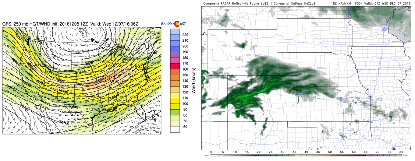
GFS 250 mb winds (left) showing a jet streak across southwest Colorado. This may result in jet-induced heavy snow bands like the one in the 4km NAM reflectivity (right).
The upslope looks okay for this event. Without a true surface low to worry about, there isn’t as much need to pinpoint an exact storm track. All of northeast Colorado should get in on persistent, widespread, but weak upslope for about 18 hours. The time-height graph below of temperature (red lines), wind (barbs) and relative humidity (blue contours) shows this nicely.
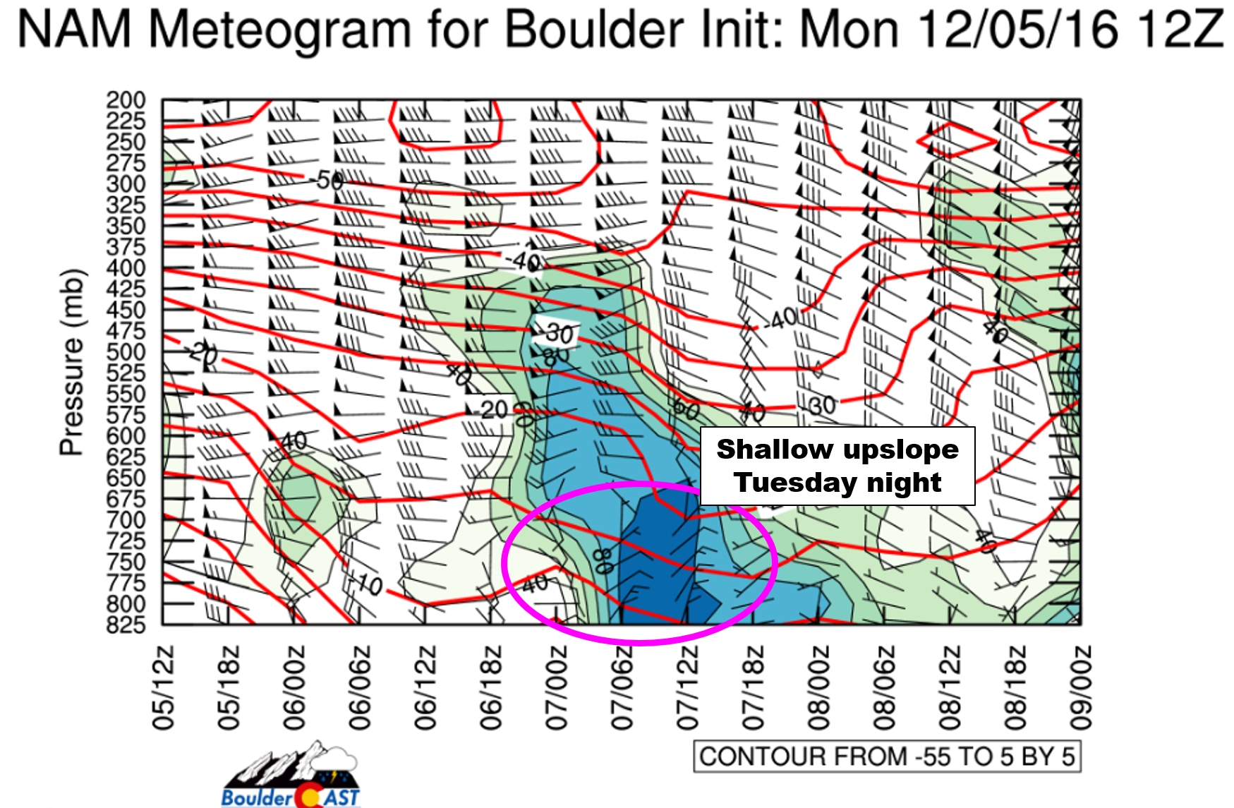
NAM model meteogram, showing shallow upslope Tuesday night
Snow will taper off Wednesday, sometime between late morning to mid-afternoon, depending on which model you want to believe. Areas in and near the Foothills, as always, will see snow linger the longest.
Amounts:
Temperatures for this storm will be the coldest so far this year. At the onset of the snow, we’ll be in the low to middle 20’s, with teens taking over Tuesday night. These temperatures, combined with the nighttime occurrence of the snow, point towards almost no melting. Whatever falls WILL accumulate. This allows us to take model liquid equivalents and snow-to-liquid ratios at (nearly) face-value.
The ensemble forecasts from the GFS (left) and SREF (right) show the potential for 0.20 to 0.40″ of liquid precipitation for the Plains.
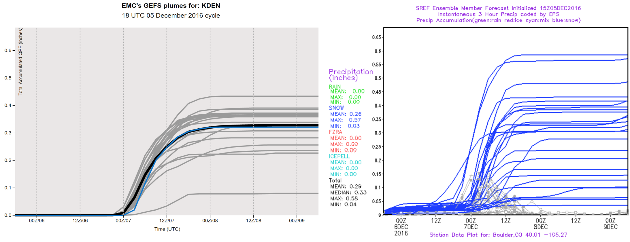
Total accumulated liquid precipitation forecast plumes from the GEFS (left) and SREF (right) models. Fairly good agreement for 0.2 to 0.4″ of liquid.
The liquid forecasts from the GFS (left) and NAM (right) are shown below. Despite the coloration differences across the region (a result of the chosen threshold), both models are fairly close around 0.20 to 0.40″ as well.
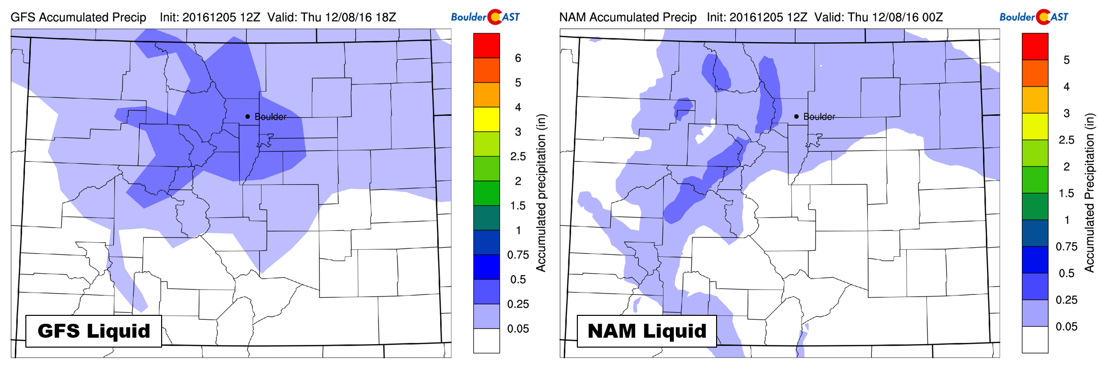
Total accumulated liquid precipitation forecast maps from the GFS (left) and NAM (right) models
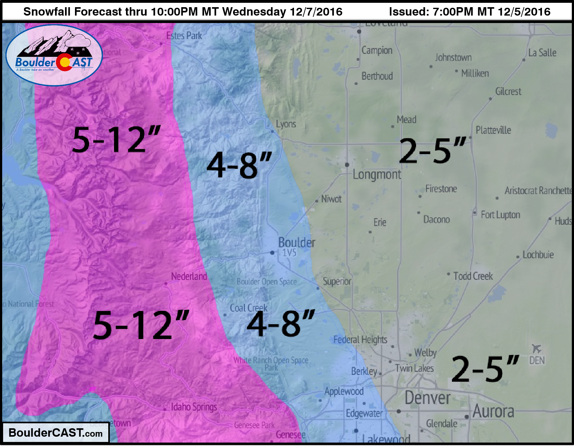
This consistency lends fairly strong confidence to how this storm will play out in general. Using snow-to-liquid ratios of 12:1 to 15:1 (which are reasonable for cold temperatures near 20 degrees), this equates to about 2 to 6″ of snow for the Metro Area. With upslope being such a vital component to this storm, expect higher totals for areas closer to the Foothills, including Boulder, Lakewood, and Golden, with lesser totals to the east. The Foothills will do better with totals ranging from 5-12″.
Below is our snowfall forecast map:
Temperatures:
The airmass with and behind this system is truly Arctic in nature. Highs Wednesday on the Plains will be in the low to middle teens. While not record-breaking, it is about 35 degrees below normal! Furthermore, with skies clearing Wednesday night and snow on the ground, it is likely many areas will drop below zero for Thursday morning. Neither Boulder or Denver reached sub-zero temperatures all of last winter, so it has been quite a while since we have experienced the chill. Denver has a good chance, Boulder has a smaller one. Foothills communities will be very cold and negative as well.
Bundle up, enjoy the snow, and have a cup of cocoa on us!


You must be logged in to post a comment.