
With another month behind us, we once again have to talk about record warmth and continued drought for the Front Range. Is the weather pattern finally set to change as we begin the month of December? Read on as we examine Boulder’s climatology and consider the current state of the atmosphere to give our outlook for the next month. We also touch on the potential for a snowstorm next week.
Recapping November
For the month, Boulder had an average temperature that was 6.4 degrees above normal (Denver was 6.8 degrees above). Following suit to the October’s historic warmth, November 2016 will go down as Boulder’s seventh warmest on record as well. The heat has been rather astonishing this year, with autumn-like temperatures being nearly non-existent. At one point, we even strung together 29 consecutive days of above normal temperatures (Oct 21st-Nov 17th). In culmination, on November 16th, Boulder hit 80 degrees, obliterating the daily record by six degrees, also setting the all-time November temperature record, and finally notching the latest 80-degree day in the books.
Only 0.47″ of precipitation accumulated in Boulder during the month of November (Denver had 0.52″), which fell as both rain and snow. Our first snow,4.4″, was finally recorded on November 17th, setting a new record for the latest appearance of snow (since 1948)! We also came within one week of being able to say the same about measurable snowfall (>0.1″).
The maps below outline November’s temperature (left) and precipitation (right) anomalies for the state.
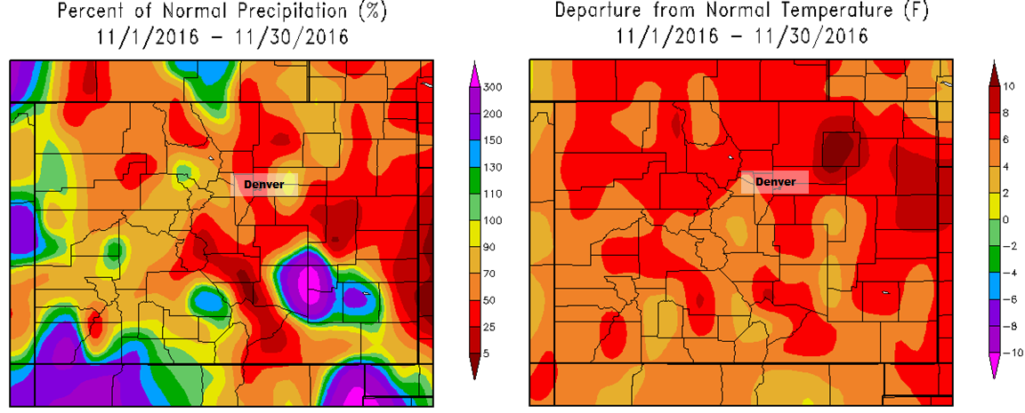
Precipitation and temperature departures from normal for Colorado for the month of November 2016.
So yeah, it was once again warm and dry… Since mid-June, only around 2.5″ of precipitation has fallen in Boulder. This is well, WELL below the normal 9.0″ that should fall during that time-frame. Five consecutive months have had below normal precipitation at this point.
As expected, the drought has significantly worsened. Shown below is the evolution of drought analysis from the National Drought Mitigation Center over the course of the last three months…vast and intense expansion.
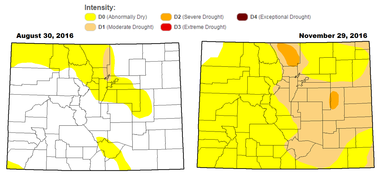
35% of Colorado is now experiencing Moderate Drought or worse, including almost all of the region east of the Continental Divide. This area of drought covers more than 75% of our state’s entire population! The wildfire threat has become extreme, with the 300-acre Green Mountain Fire earlier in the week south of Denver being a clear example of this.
If you recall, our November 2016 outlook called for above normal temperatures (correct!) and near normal precipitation (wrong!) for the Denver Metro area. Here’s how some various inputs into our forecast panned out:
- ENSO: We expected a La Niña to finally take hold in the Equatorial Pacific during the month of November, which it did as the Oceanic Niño Index crossed beneath the -0.5 degree Celsius threshold. Though, it’s not very important as we were unable to find any significant linkages between Front Range weather in November and a marginal La Niña.
- Weather Model Ensembles: The ensembles handled the first 15 days of November exceptionally well for the United States as a whole. We discussed that ridging would remain in place for at least the first half of the month, keeping Colorado very warm. We also mentioned towards the end of the month, the ridge would break down to usher in cooler weather and more chances for precipitation.
- CFS Climate Model: The CFS had almost all of North America under very warm conditions (largely verified!). For Colorado, the model projected normal precipitation, which was incorrect.
- BoulderCAST Analog Forecast: Our own hand-crafted analog forecast pointed to below normal temperatures for the entire state (boo!). They also suggested near-normal precipitation for the Front Range (also boo!), but ticketed the southern portion of Colorado for above normal precipitation (portions of southern Colorado were well above normal precip).
- NOAA’s CPC: NOAA had the Front Range in elevated chances of above normal precipitation (very wrong!) and temperature (correct!).
Shifting focus to the next month…normally, December across the Front Range starts to feel downright cold, with one or two decent-sized snow events. Let’s take a closer look!
December Precipitation History:
On average, Boulder receives 0.91″ of precipitation in December, making this our third driest month of the year.
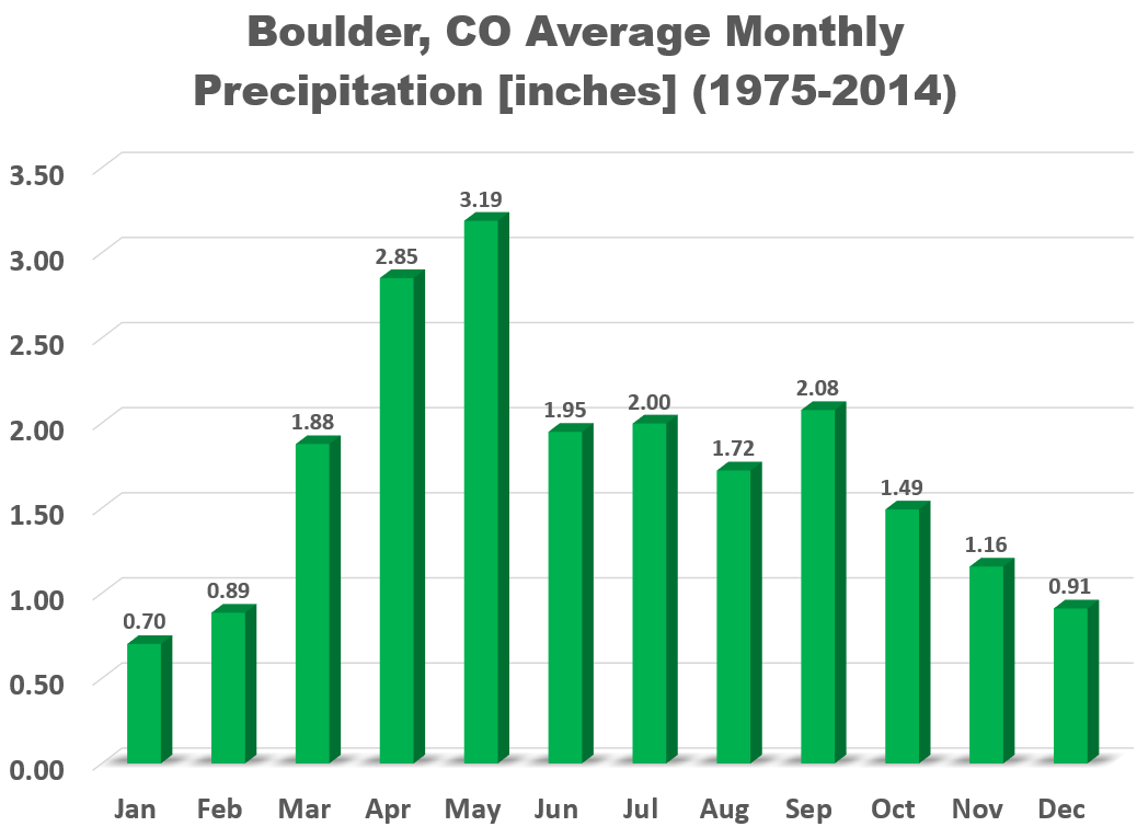
Many Decembers have less than 1″ of precipitation, however, in 1913, 4.20″ was recorded (it was all in 53″ of snowfall).
December Temperature History:
Leading into winter, December continues the downward trend in temperature for the region. The average high slowly declines from 50 degrees on the first of the month, to just 42 degrees by the beginning of the New Year. Mean overnight lows fall from 26 to 18 degrees over the course of the month.
The hottest temperature during the month of December was 75 degrees, observed on December 4, 1965. On the 22th of December in 1982, the temperature dropped to a icy -24 degrees. This means our temperatures have impressively ranged a whopping 99 degrees during the month.
——
This Year’s December Outlook:
Below we review several factors individually that we take into consideration for our outlook of December.
EL NIÑO / LA NIÑA:
The equatorial Pacific Ocean has officially shifted into a La Niña phase for the first time in four years. The graph below shows the sea-surface temperature anomaly for NINO Region 3.4, the primary area used for El Niño/La Niña monitoring.
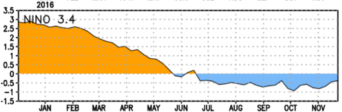
Current temperature anomaly plot for NINO 3.4.
Looking forward, climate model forecasts keep a weak La Niña through the winter, transitioning back to neutral in the February time-frame.
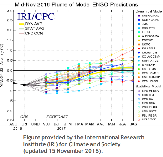
Model ensemble forecasts for Nino 3.4 region temperature anomaly.
Based on our ENSO analysis, and expecting we remain within a weak La Niña for the month of December, we found the odds of a snowier than normal month are quite high. Since 1950, 8 out of 10 weak La Niña Decembers have had above-median snowfall. This bodes well for the snow-lovers out there! We also found that those same Decembers had a median temperature two degrees lower than typical. While not overwhelming relationships, December has a fairly strong La Niña signal for the Front Range, as we mentioned, skewed towards the “cold and snowy.”
WEATHER MODELS:
Ensemble models show a somewhat active first half of the month, with numerous troughs and ridges moving across Colorado (see the GFS animation below). The trough early next week, in the Monday/Tuesday time frame, looks especially intense. It will bring a big cool down and a chance of snow for Colorado. Towards the tail-end of the animation below, we see a ridge beginning to build back in. Though, the Euro ensemble is less optimistic about this ridge returning…
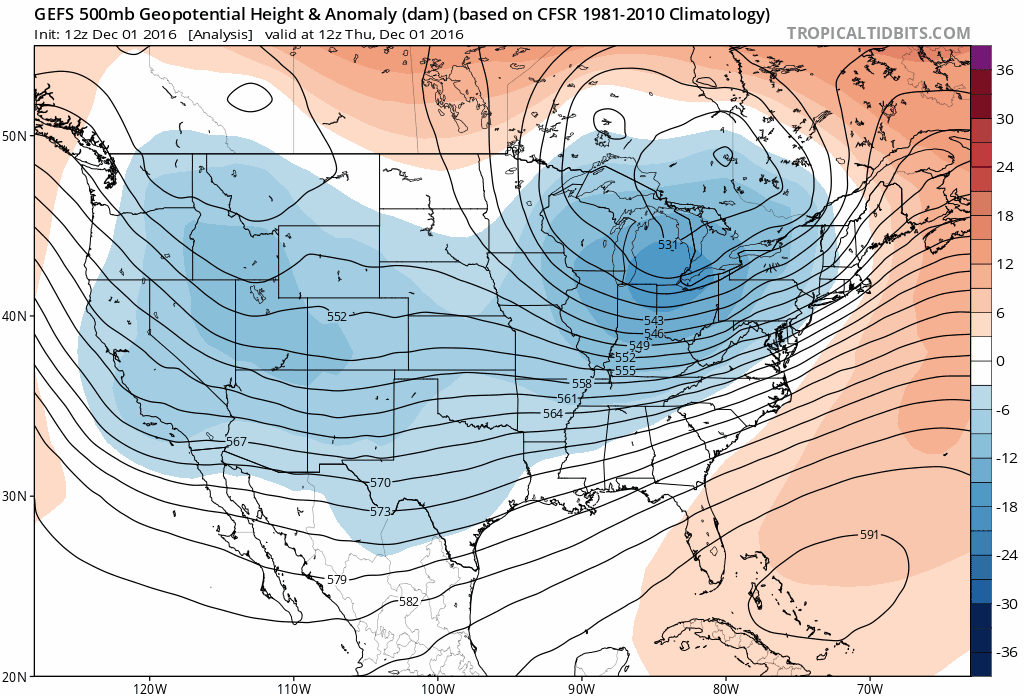
GFS ensemble forecast for 500 mb height through mid-December
CLIMATE MODELS:
We often consult the Climate Forecast System long-range model to help guide any potential forecast for the upcoming month or season. As you can see below, the CFS model is thinking cool and wet! It’s been quite a while since those predictions have been made together! In theory, this suggests quite the snowy month as well.
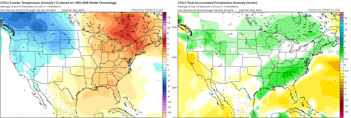
Climate Forecast System outlook for December’s temperature (left) and precipitation (right) anomalies.
BOULDERCAST ANALOGS:
Based on what 2016 has dished out recently, our algorithms choose the top ten historical analogs (years that thus far have been most similar to 2016 in regards to temperature and precipitation for the Front Range). They point towards this December being warmer and wetter than normal across the Front Range.
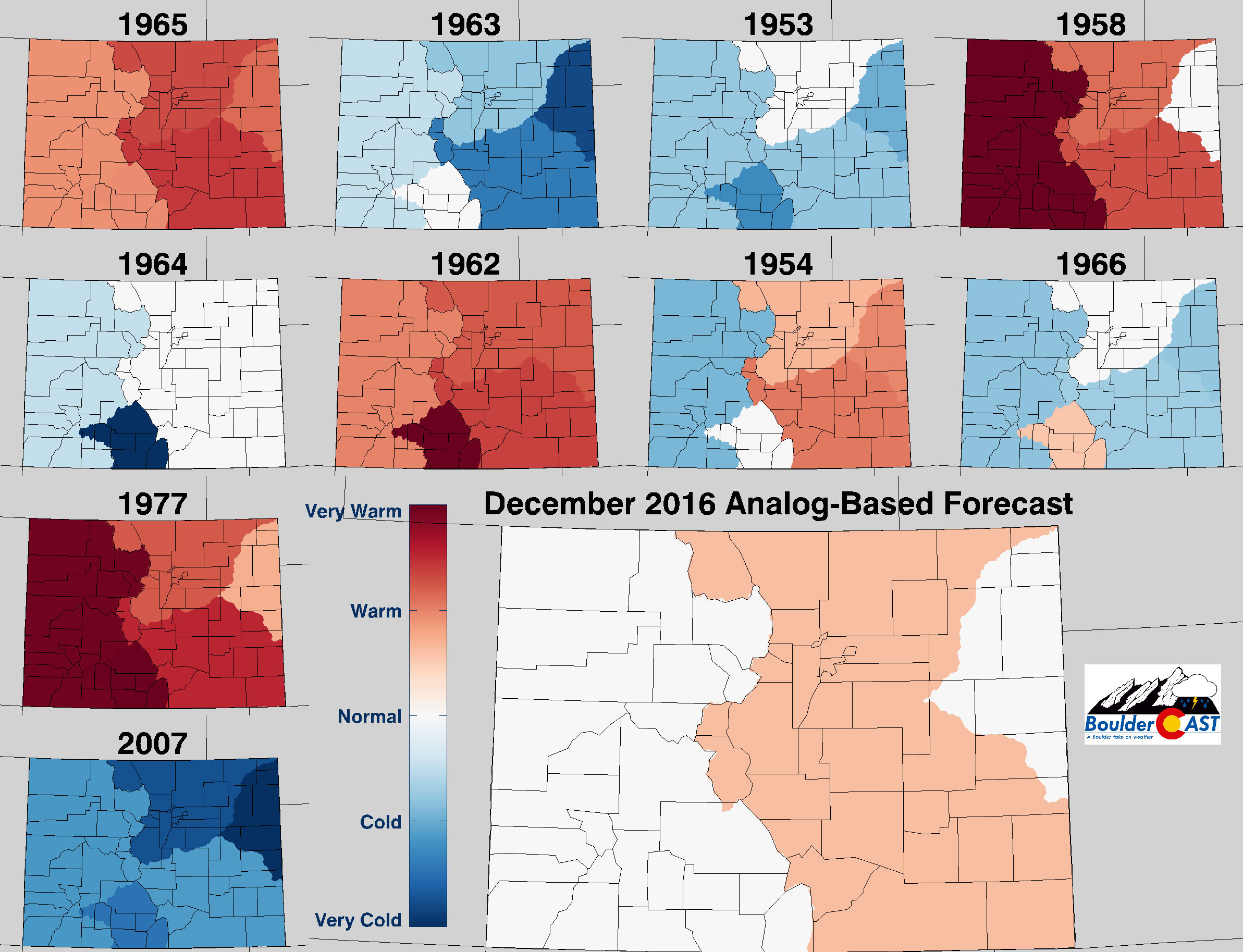
Top 10 Analogs to 2016 and how those years played for TEMPERATURE in Colorado during the month of December. The large map shows the analog-based weighted consensus forecast based on those 10 years.
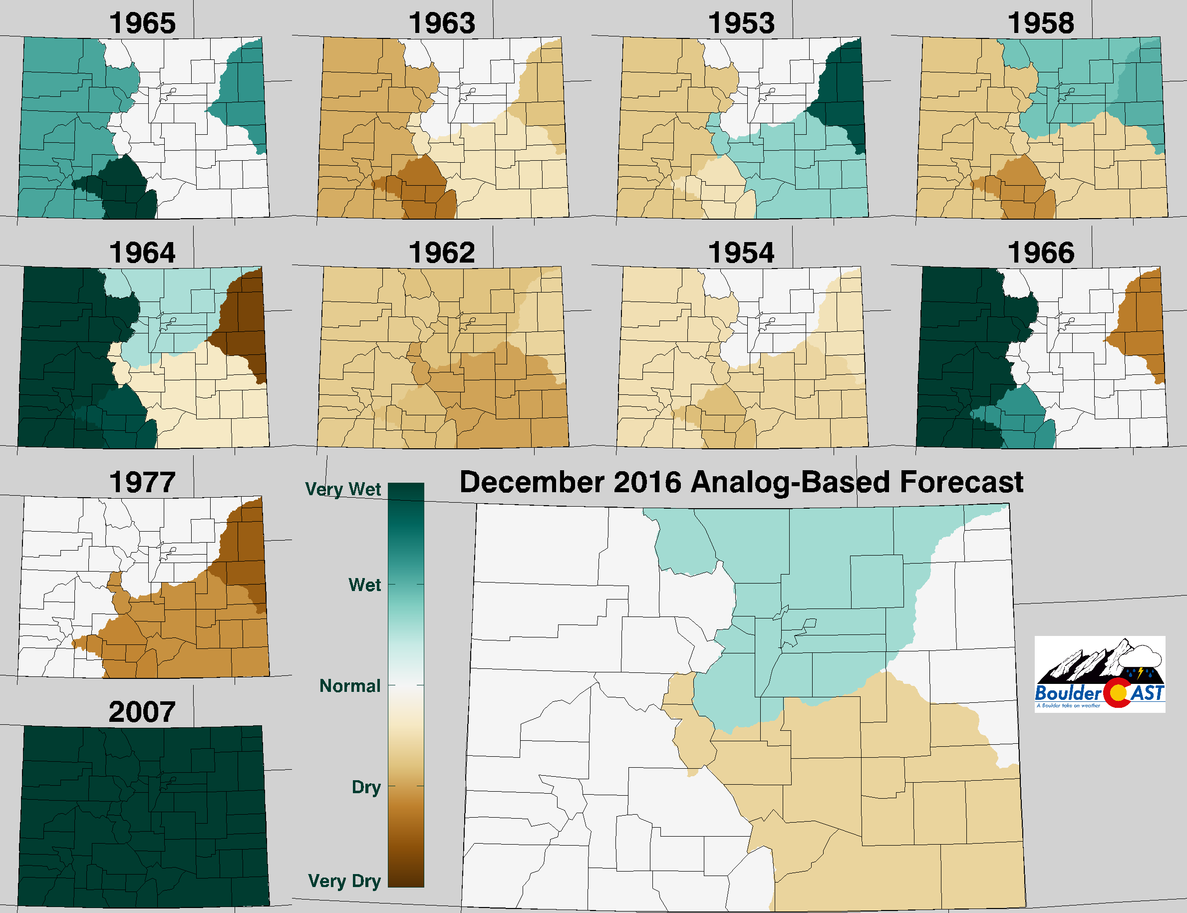
Top 10 Analogs to 2016 and how those years played for PRECIPITATION in Colorado during the month of December. The large map shows the analog-based weighted consensus forecast based on those 10 years.
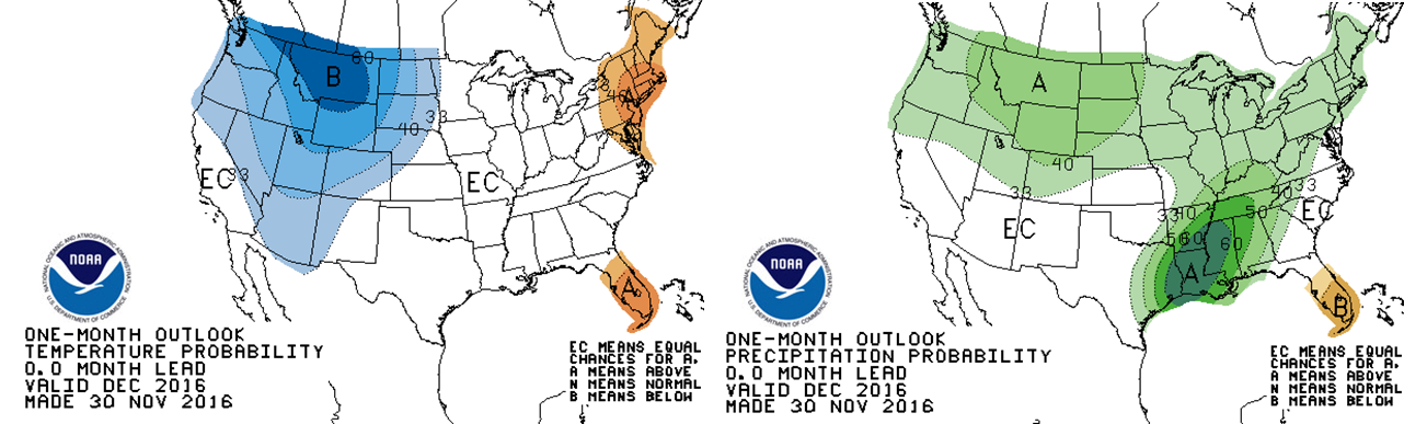
NOAA’S CLIMATE PREDICTION CENTER:
The Climate Prediction Center has Front Range Colorado within elevated odds of above normal precipitation and below normal temperatures as well (very similar maps to the CFS model).
Climate Forecast System outlook for December’s temperature (left) and precipitation (right) anomalies.
IN SUMMARY…
Considering all of the aforementioned factors, BoulderCAST is predicting below normal temperatures for December with above average precipitation (snow!) for the Front Range.
We like the look of the weather pattern the models are projecting right now, especially that storm next week. We do note that despite the troughs, none of them persist. Most should be quick moving, with relatively fast warm-ups thereafter. We believe temperatures will end up below normal, but not significantly so. We should be able to squeak out three or four snow events, likely exceeding our typical foot of snow during the month. Just about all inputs into our forecast point towards a wet December so our confidence is elevated.
Get your winter attire ready! The first full-week of December will truly feel like winter as Colorado will find itself within the heart of an Arctic airmass by the middle of next week (see below), with snow likely flying (below as well). More on that in our weekly forecast Monday. Have a great weekend and month!

GFS forecast temperature anomaly for next Wednesday. Brrr!
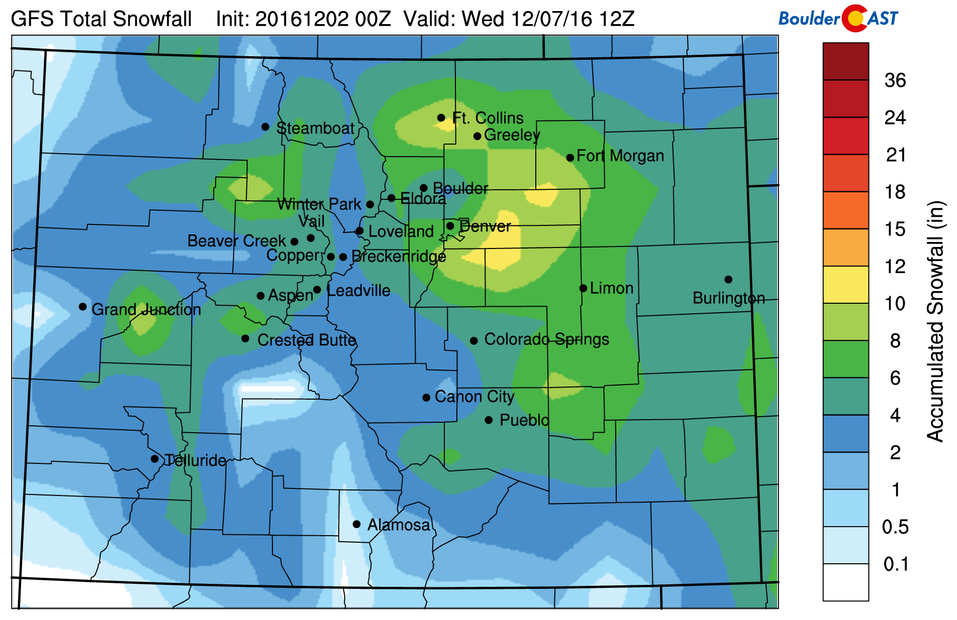
GFS model snowfall forecast for the system early next week.


You must be logged in to post a comment.