We’re currently about one week away from setting the record for our latest first snowfall in a season. It’s likely a lost cause, though. Following two days of incredible November heat, it finally appears that winter will make a tiny breakthrough and produce a little bit of snow for the Front Range tomorrow afternoon and evening. Read on for all the details and to see our final forecast snow map.
It’s hard to believe that this time tomorrow, temperatures will be 40+ degrees colder and snow will be flying! It’s a challenge to find anywhere in the country that can pull this drastic change of weather off as well as Colorado. On both Tuesday and Wednesday this week, records were obliterated across the region, with temperatures near 80 degrees.
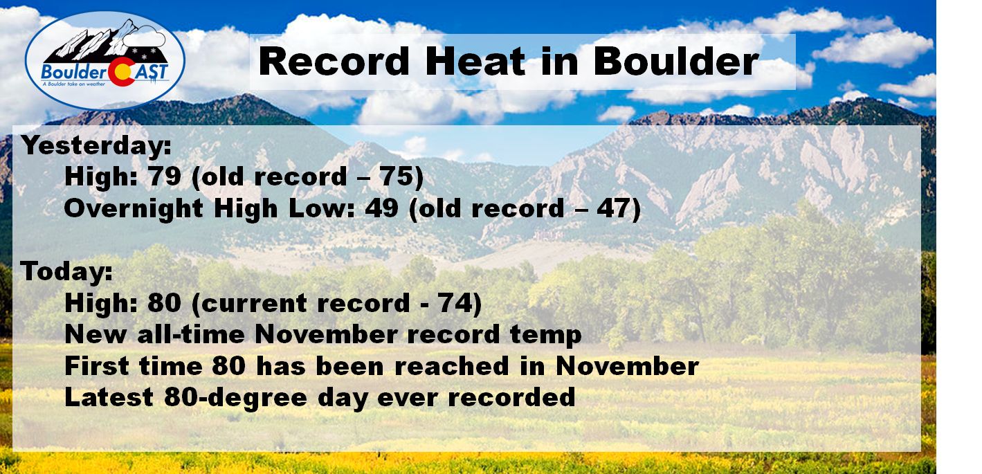
It’s not very often you smash a daily record high by SIX full degrees! Tomorrow’s evening commute will be quite the shocker for many!
Our snow-maker has already come ashore earlier this morning in northern California. Moisture has been streaming northward ahead of the trough into Colorado (see water vapor image below). You may have noticed the increased cloud cover today…
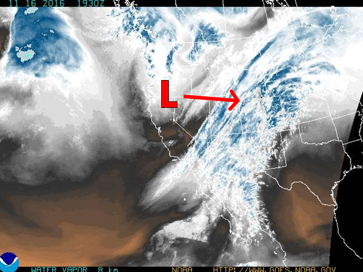
Water vapor image for Wednesday afternoon, showing the upper-low coming ashore and clouds/moisture spreading into Colorado ahead of the system
Over the last week, the storm’s track has slowly inched further southward (as we suggested may happen in our update a week ago). It has transitioned from a complete downslope event (no snow!) to a minor event that should provide most of the Denver Metro with their first snowfall of the 2016-2017 winter season. If this storm were happening in late January, it would barely be worth a mention. But alas, first snows always get extra attention, no matter how small…
Temperatures tonight will be very warm, remaining in the 50’s for some time. Our rude and wintry awakening arrives via a powerful cold front from the north late tonight. Behind it, temperatures will fall into the 30’s with precipitation developing later in the morning. It may initially being as rain, but it should quickly transition to snow for everyone by early-afternoon.
The system is quite a fast-mover (see below). This is one reason we’re expecting very modest snow totals. Snow will generally be light, and at least initially before sundown, will have a tough time accumulating considering the recent record warmth, melting on contact. Moisture is also lacking, as precipitable water values peak around 0.3″ Thursday during the early evening, then fall steadily.
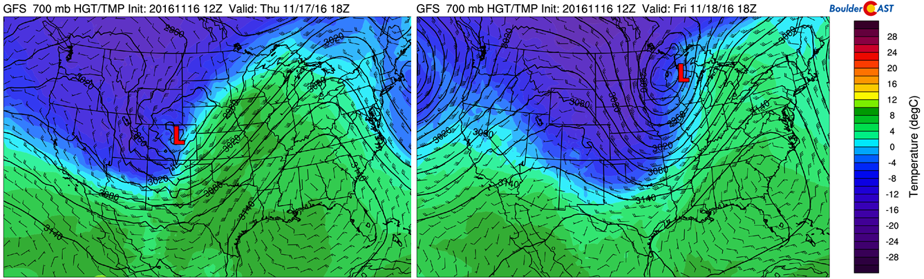
GFS 700 mb heights/temperatures for Thursday morning (left) and Friday morning (right). This demonstrates just how quickly the storm is moving..already over the Great Lakes by Friday morning.
Three of the four big models are on-board to produce snowfall for the Front Range Foothills and Plains (GFS, Euro, Canadian). The NAM model, though, remains insistent on a more northward track that entirely downslopes Boulder/Denver and amounts to no precipitation at all for us. However, we will be following the majority and most likely scenario given how things are progressing today. Though, the GFS has been trending northward, albeit only slightly, in its last couple runs.
The GFS model projects only a brief period of shallow upslope, which at times, may be quite strong (NNE at 20 knots at 10,000 feet). The best time-frame for light snow will be between 11am and 9pm, with a focus around the afternoon hours. Snow should quickly come to an end around midnight Thursday evening, or slightly after for some locations.
The GFS ensemble produces 0.15 to 0.35″ of liquid equivalent for the event, with fairly minimal spread. This should be enough for an inch or two of snow in most locales.
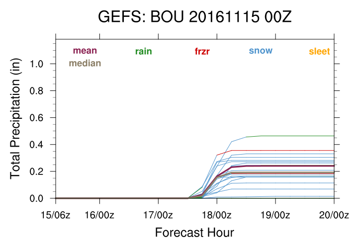
GFS ensemble forecast total precipitation for the event. Both the mean and median are near 0.25″
So in summary….
The Good (if you want snow)
- Powerful fall storm that rapidly intensifies in eastern Colorado
- Some upslope is present
- Decent large-scale lift Thursday afternoon and early evening (yay trough!)
- Plenty of cold air for snow
The Bad
- Quick-moving system, with only a brief period of “okay” conditions for snow
- Track not ideal…still too far north.
- Limited moisture
- Warm ground will inhibit accumulation
Amounts
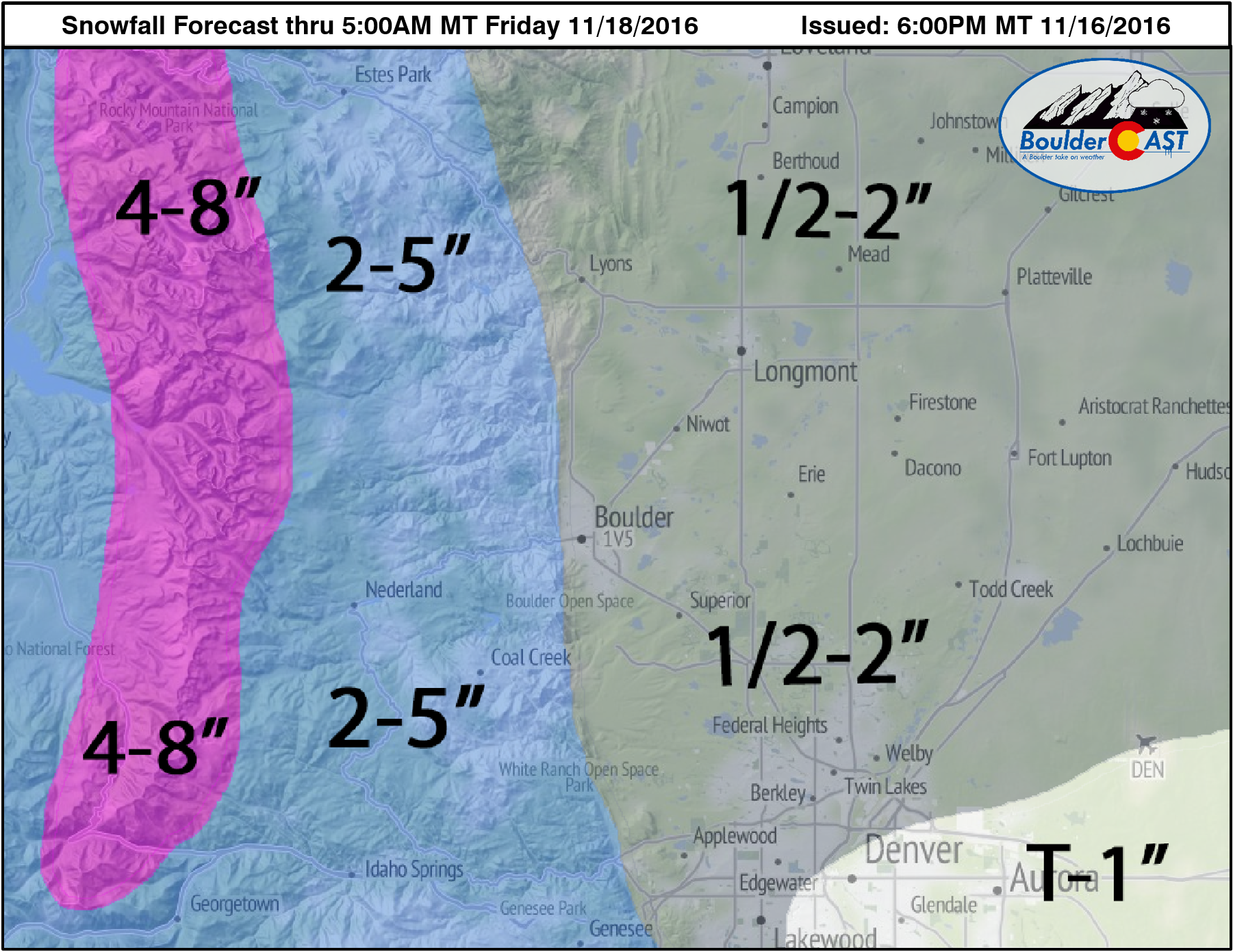
Considering all of the above factors, it looks as though we’re all in store for *some* accumulating snow tomorrow. Some places may just wind up with a tiny amount on grassy surfaces, others may get a couple inches. We expect the higher totals to be biased west and north across the Metro area. With cooler temperatures overall, the Foothills, especially from Boulder County northward, should do a little better. Our snowfall forecast map below reflects our thoughts.
If you missed our PowderCAST Ski Forecast from earlier today, you can find that here for more info on which resorts may get the most snow.
Enjoy our first taste of winter, as meager as it may be!


You must be logged in to post a comment.