We examine last week’s winter storm and review the snow totals and temperatures. Where does this leave us in relation to normal for the 2016-2017 winter season? Read on to find out.
Upslope delivers
The weather models had a remarkably good handle on last week’s storm, at least five days in advance having the basic track and intensity already nailed down. The set-up had a weak system moving across northern Colorado from the northwest, with an Arctic high pressure providing very cold air and weak upslope to the Front Range. The storm was set to bring around ~0.30″ of liquid to the region, and the coldest air we’ve seen in almost two years.
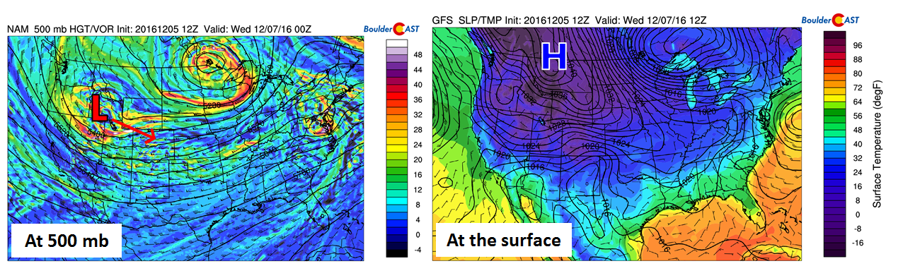
Storm setup at 500 mb (left) and at the surface (right)
Our final forecast called for 2-6″ across most of the Plains, with 4-12″ in the Foothills. Snow began right around Tuesday’s evening rush hour and lingered into Wednesday morning or afternoon (for some spots).
Shown below is our original forecast map created last Monday evening. The observed storm totals per location are contained in boxes. Green ones indicate that the observed snowfall was within one inch of the given forecast range, while red was outside the scope of our forecast.
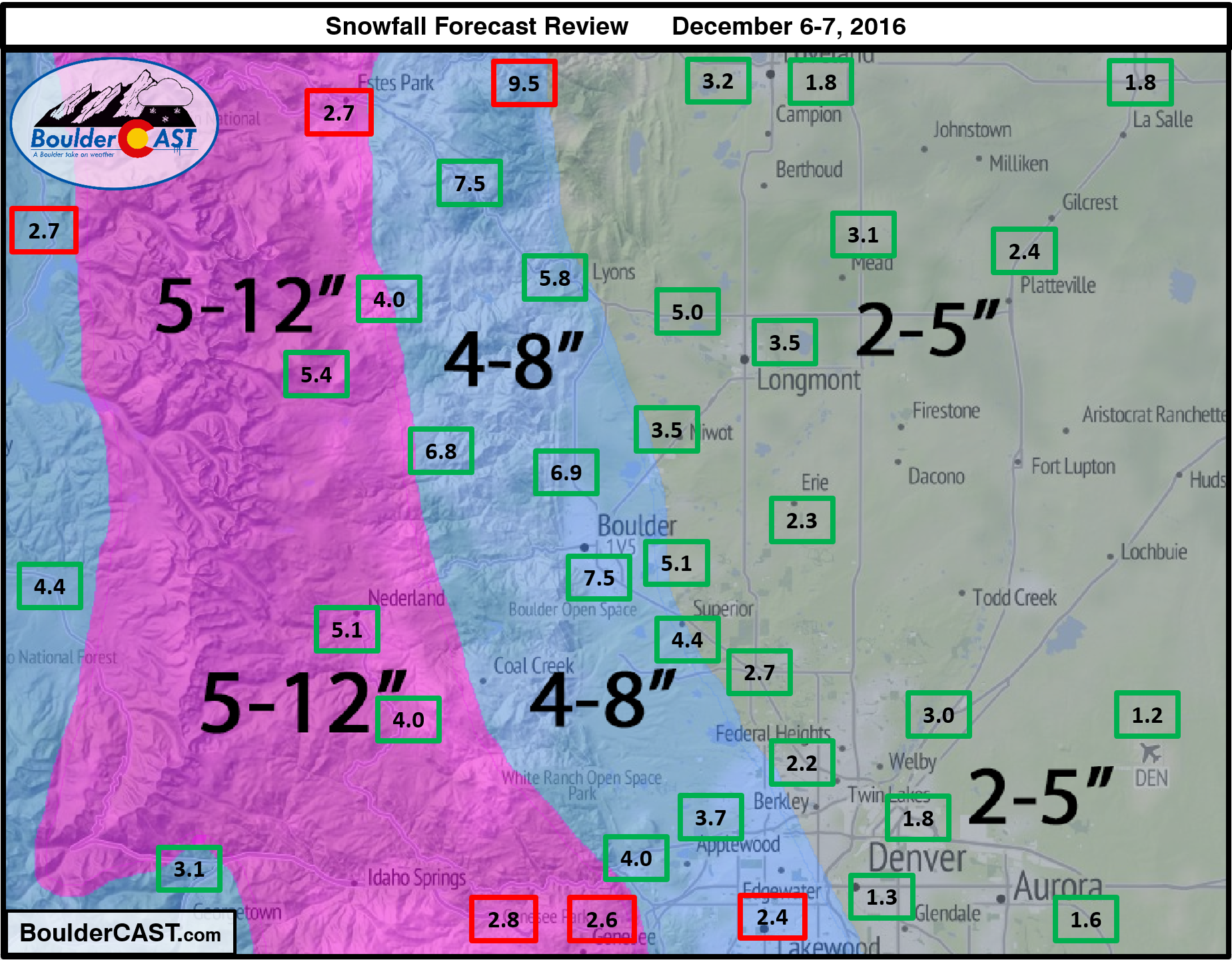
Boulder officially recorded 7.5″ of snow from the event, while Denver only managed 1.2″ (at DIA). With upslope being such large component to this storm (more so than usual), this east-west disparity was expected between the two cities.
Most areas across the Front Range landed comfortably in the “green” for this storm. Though, here are a few observations:
- The NAM model was showing a distinct northward variation from the other models, keeping the higher snow totals north of Denver and Boulder, across Ft. Collins towards the Wyoming border. While this wasn’t entirely accurate, the higher amounts were biased northward. South Denver and the Foothills along Interstate 70 were lacking their expected snow.
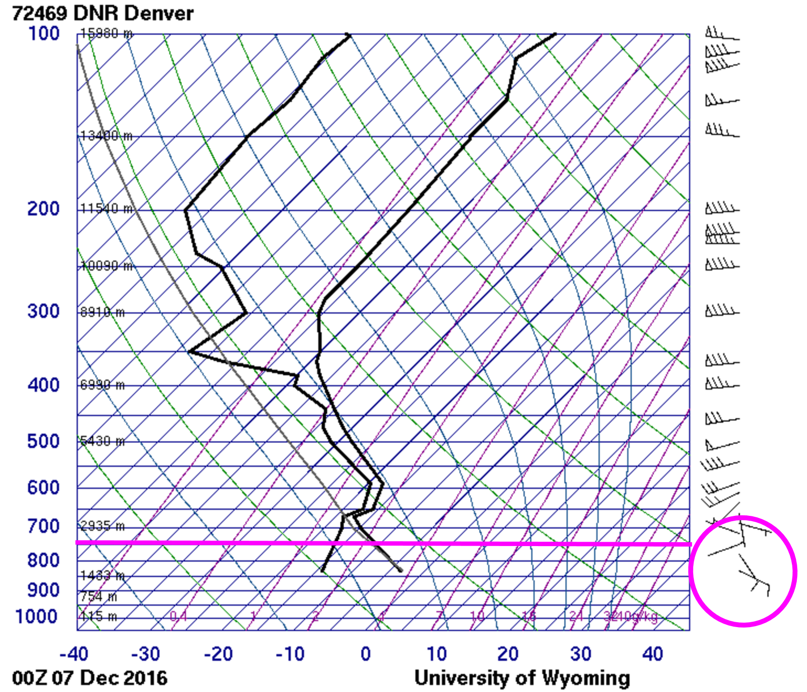
- With the shallow Arctic component to the upslope, we were concerned about the potential for the higher Foothills to see limited snow. Models forecasted that winds with an easterly component (upslope) would be confined to below about 725 mb. This corresponds to about 8,500 feet elevation. The radiosonde launched at DIA Tuesday evening at 5PM (skew-T shown below), right around the start of the storm, shows that upslope was weak and present mostly below 750 mb. For more intense storms, upslope can exist up to 500 mb or even higher. This is likely the reason snow totals in the higher elevations were towards the lower end of our forecast range (and part of the reasoning for the relatively large 5-12″ range to begin with).
Arctic air brought negative temps
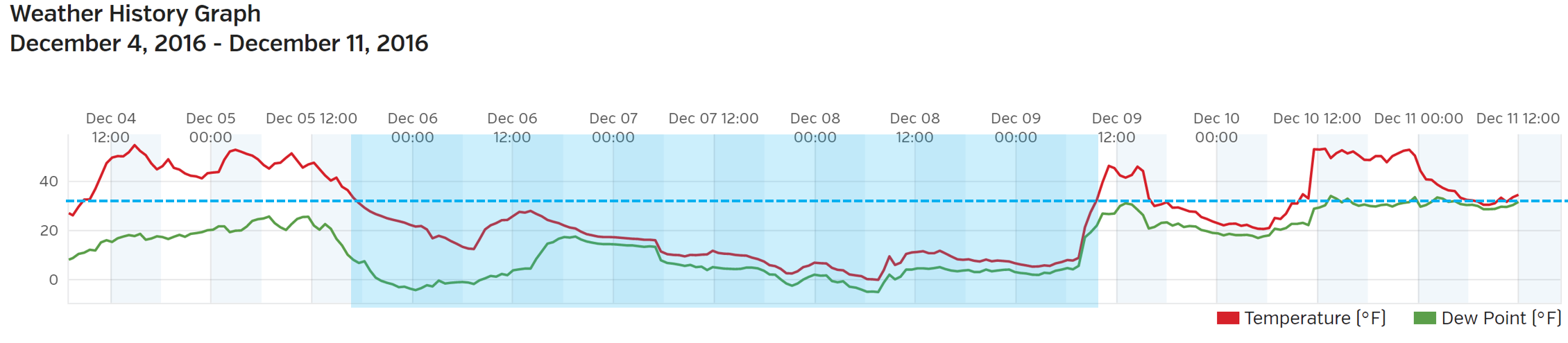
On the backside of the storm, skies cleared and allowed for temperatures to drop below zero for most locations. This hasn’t happened in Boulder since New Year’s Eve 2014. The official overnight low Thursday morning was -3 in Boulder, and -10 in Denver. Temperatures remained below freezing for some 90-hours in Boulder. The time series below shows the temperature (red line) at BoulderCAST Station over the last week. The blue coloration denotes those consecutive sub-freezing hours.
How far down are we this year in snow?
Including the coating of snow that fell earlier this morning, Boulder’s seasonal total sits as 12.3″. Through December 11th, “normal” would be about 22″. Denver has a meager 3.0″ so far, well below the average value of 17″. With ensemble models continuing to advertise an active pattern moving forward, a little catch-up may be possible this week. More on that in our weekly outlook tomorrow.
Heavy snow has fallen in the Mountains this weekend, with more on the way Tuesday into Thursday. Many areas have received one to two feet of powder. Avalanche warnings are currently in effect for much of the High Country right now. Be extra cautious if heading out to the back-country. The data hasn’t been updated to incorporate the latest round of snow yet, but South Platte snowpack was at 55% of normal beforehand. We expect that to jump to around 70% on the next update. Improvement, but still plenty of work to do.
Check out our 2016-2017 Winter Forecast Summary for an overview of how the winter has played out so far in your location. This page will continually be updated as the winter progresses.
That’s all for now… Let it snow!


You must be logged in to post a comment.