Changes to the forecast bring the return of accumulating snow to the Front Range. We detail when we expect the snow to start and how much will fall.
What happened to the fair weather and sunshine?
For the last several weeks, the weather across the western half of the country has been dominated by a resilient ridge of high pressure. Beneath this ridge, California has been burning, while western Canada and Alaska have experienced unprecedented warmth with temperatures averaging more than 15 or 20 degrees above average for the month.

We haven’t been quite this toasty in Colorado, but Boulder’s average temperature for December through the 13th is running 9 degrees warmer than normal. This pattern began more than three weeks ago, and led to our second warmest Thanksgiving on record.
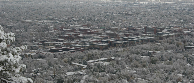
The ridge has also protected us from conditions conducive for snowfall, both in terms of moisture and upslope, in addition to temperature. Boulder hasn’t seen accumulating snowfall in some 36 days (4.4″ on November 7th). This powder-drought goes all the way back to October 11th for Denver (63 days).
In our extended forecast update last week, we issued a few very relevant words of warning regarding the ridge across the West:
- While it’s a near-certainty that dangerous wildfire conditions will stubbornly linger across California, our forecast here isn’t necessarily as set-in-stone. We most certainly won’t see any huge snow events in the foreseeable future, but the northwesterly jet stream will be nearby for an extended period, keeping the door open for frequent cold intrusions associated with the trough in the eastern United States. Under this pattern, any small meander westward could bring wintry conditions to the Front Range this time of year. Nothing significant, but a storm producing a few powdery inches is entirely possible.
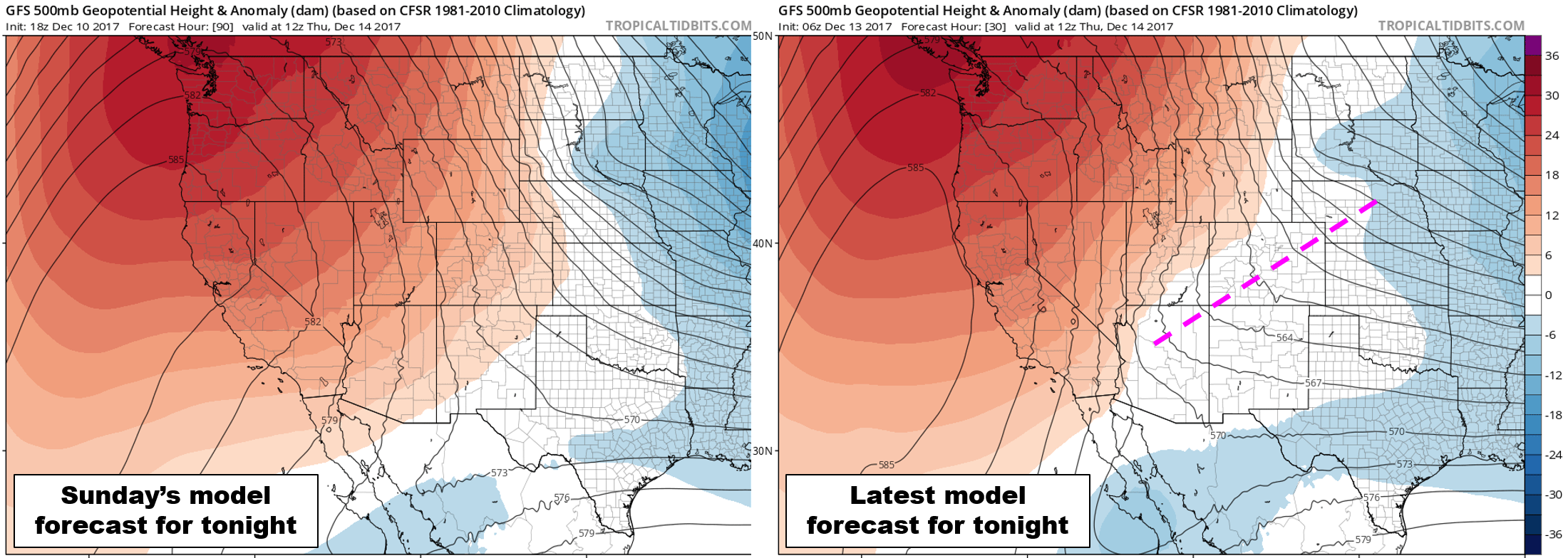
While the ridge has been pesky, a subtle shift in the weather pattern will be turning things more active across Colorado. The eastern flank of the ridge has broken down and shifted ever-so-slightly westward. This is apparent in the two 500 mb forecast maps below. The one on the left is from the GFS model on Sunday, forecasting for tonight. The one on the right is from this morning, also forecasting for tonight. You’ll be hard-pressed to find any differences between the two. The GFS really did a good job with this pattern in general. The one exception, unfortunately for us, is across Colorado. Notice the westward shift in the red coloring (ridging) and even a weak trough across the state.
This change has thrown a major wrench into our weather for the next three to five days. The first hill to climb is a forecast for snow tonight across the Front Range…
Light snow late Wednesday night
The cold front was expected today all along in our forecast. However, thanks to the changes discussed above, it now has colder air and more “oomph” for upslope, along with a fair amount of low and mid-level moisture to work with. Ultimately, the limiting factor for tonight’s snowfall will be the small-scale nature of the system, and its quick movement.
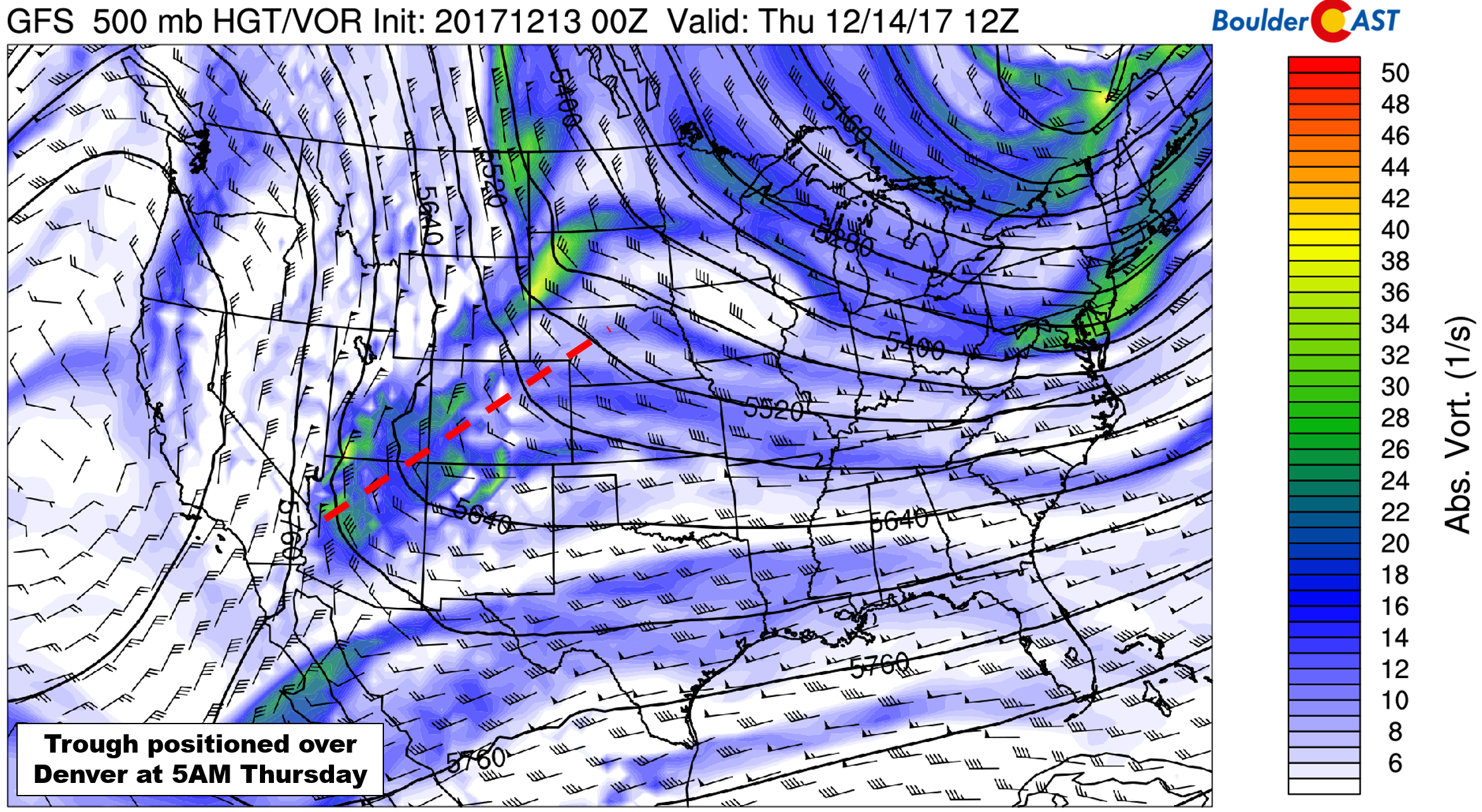
GFS 500 mb forecast for tonight
As the energy progresses across the state tonight, we expect snowfall to increase in coverage across the higher elevations after 9:00 PM. It will take extra time for the lower levels of the atmosphere to cool and moisten up in the Metro area, but we should begin to see light snowfall developing after midnight across the Plains. This will coincide with a secondary push of cold and moist air, dropping our temperatures into the upper 20’s.
The system quickly moves southward and weakens, with snowfall tapering off around sunrise Thursday morning. Thus, we’re only looking at about a 6-hour window for accumulating snow. Jet forcing is minimal this time around. The main drivers for snow will be shallow upslope and mid-level forcing from the passing trough axis.
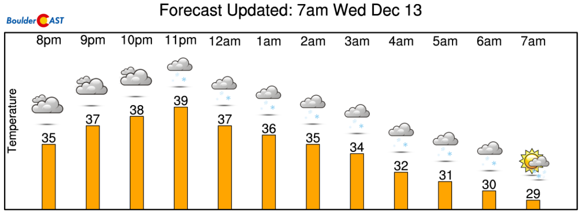
Hour-by-hour forecast for Boulder tonight from NowCAST
Models and their ensembles are in good agreement overall for this event, so our confidence is….let’s say, “higher than normal”. The GFS ensemble plumes in Denver show around an inch of accumulation (at DIA). 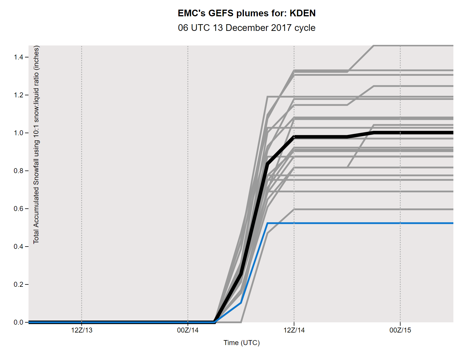
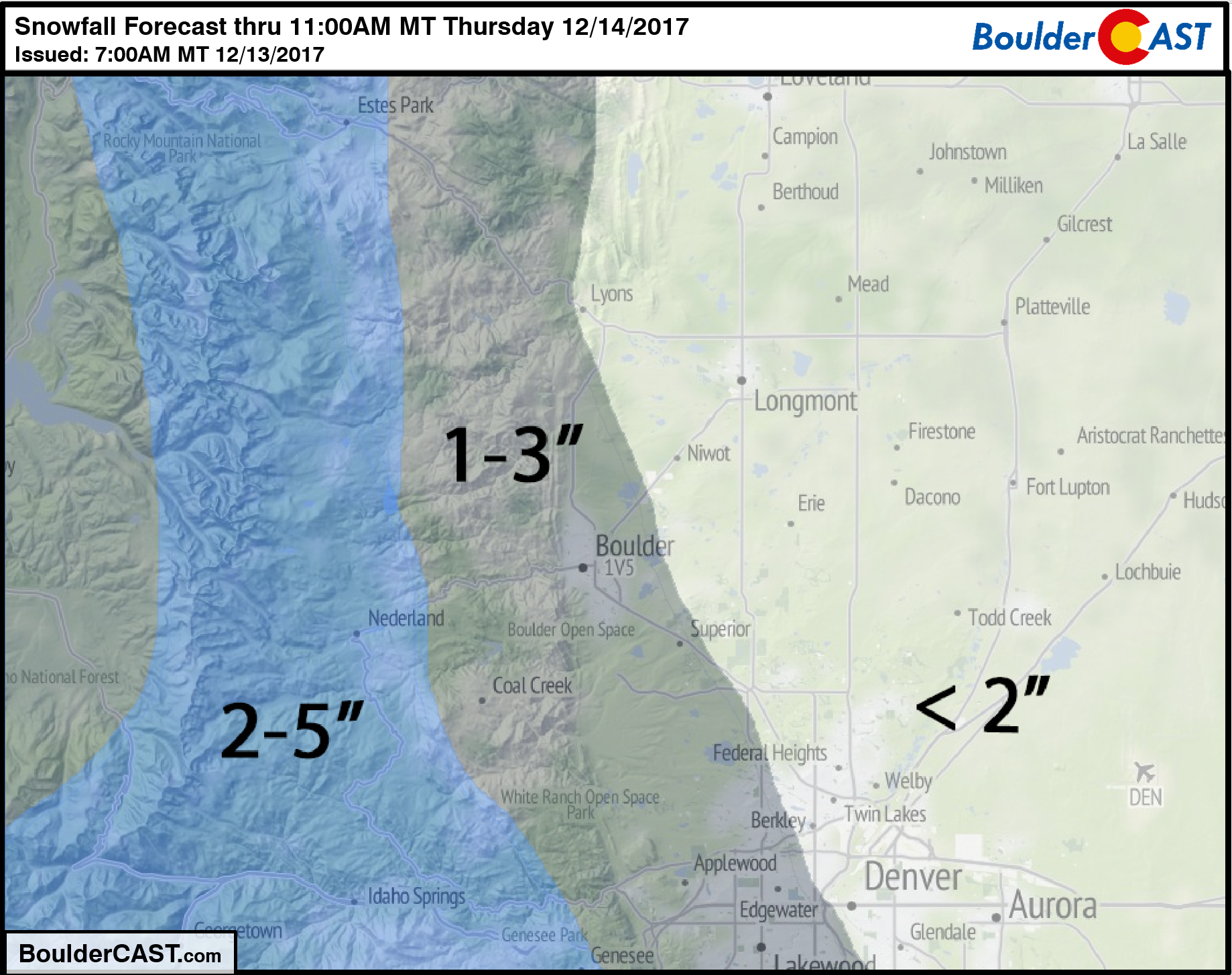
In general, we’re looking at 1-3″ for the lower elevations, with the highest amounts west and south of Denver where upslope will be amplified. Totals of 2-5″ can be expected in the Foothills and across many of the ski resorts. Our snowfall forecast map is shown below.
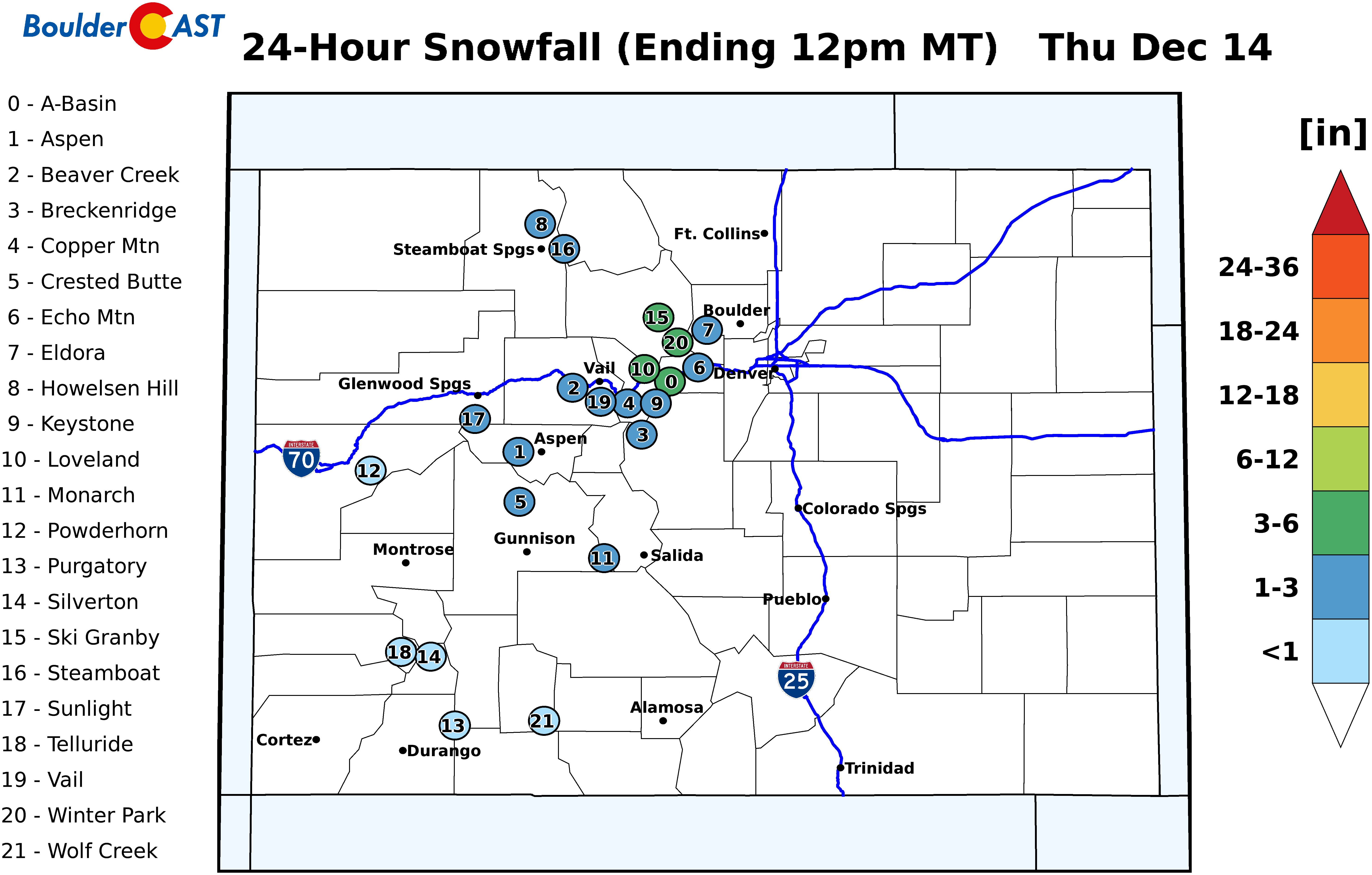
PowderCAST ski forecast map for this event
Thursday’s morning commute could see minor impacts given the timing of the snow. This is especially true considering the length of time since our last accumulation. Many folks may have forgotten how to drive on slick roads, or what snow even is!
Skies will begin clearing by lunchtime Thursday as drier air and subsidence take over across the state. We should be able to reach into the 40’s with the snow at least beginning to melt.
Stay safe and enjoy the brief return of winter. Another chance of (potentially more significant) snow comes Saturday night, but that is a topic for another day!
Share this forecast:
.


You must be logged in to post a comment.