There’s no rest for snow-lovers these days! Just as one snowstorm comes to an end, another one is already taking shape to impact the Front Range Tuesday into Wednesday. We take a look at snow totals from the first wave and discuss the evolving forecast for part deux!
UPDATE (7:00 PM Mon 10/28/19): Added our official snowfall forecast map to the end of the post!
PREMIUM UPDATE (7:00 AM Tue 10/29/19): We do a quick check on how the forecast looks this morning as snow begins to fall and bitter cold temperatures push in from the north. Click HERE to read.
We discuss Boulder and Denver weather every single day on BoulderCAST Premium. Sign up today to get access to our daily forecast discussions every morning, complete six-day skiing and hiking forecasts powered by machine learning, access to all our Front Range specific weather models, additional storm updates and much more!

ARCTIC BLAST PART ONE:
Snow totals from Sunday into Monday morning
t seems like an eternity ago, but the initial Arctic cold front plowed into the Denver Metro area Saturday evening around sunset entertaining 40 MPH wind gusts and a sharp drop in temperatures.

Daily weather history graph from BoulderCAST Station on Saturday showing the passage of the initial cold front
Not long later, light drizzle broke out around midnight Saturday night. As temperatures fell below zero at ground level, this drizzle began to freeze on contact early Sunday morning. Eventually the atmosphere cooled enough to turn things over to light snow across the area around sunrise Sunday. Since then, it has been snowing almost continually in many areas. Snowfall intensity has been highly variable over both time and location, from just flurries to absolute wintry deluges in some of the heavier jet-forced snow bands.
The radar animation below covers 8PM Sunday to 8AM Monday. How many snow bands impacted YOUR area overnight?
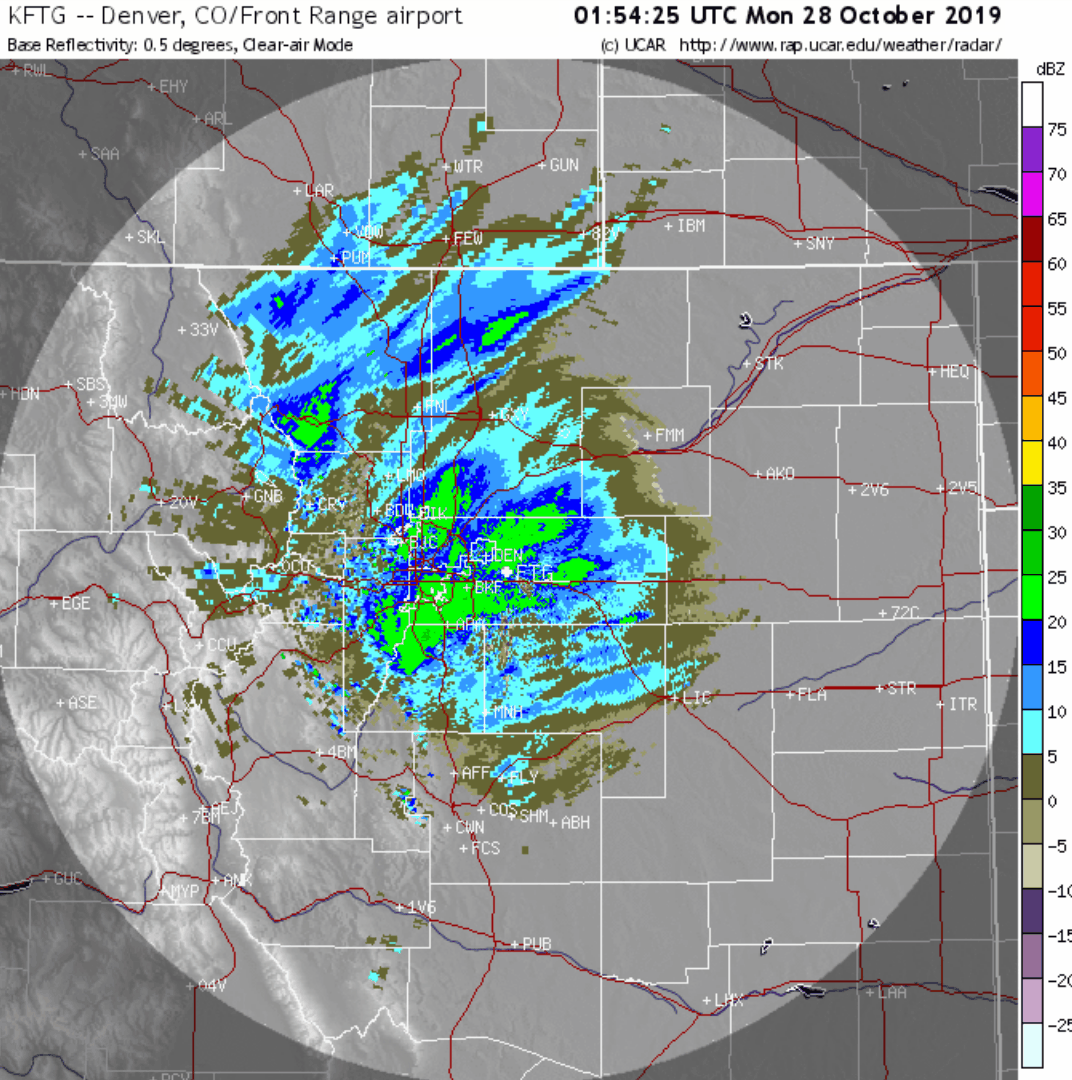
Storm radar animation covering 8PM Sunday night to 8AM Monday morning
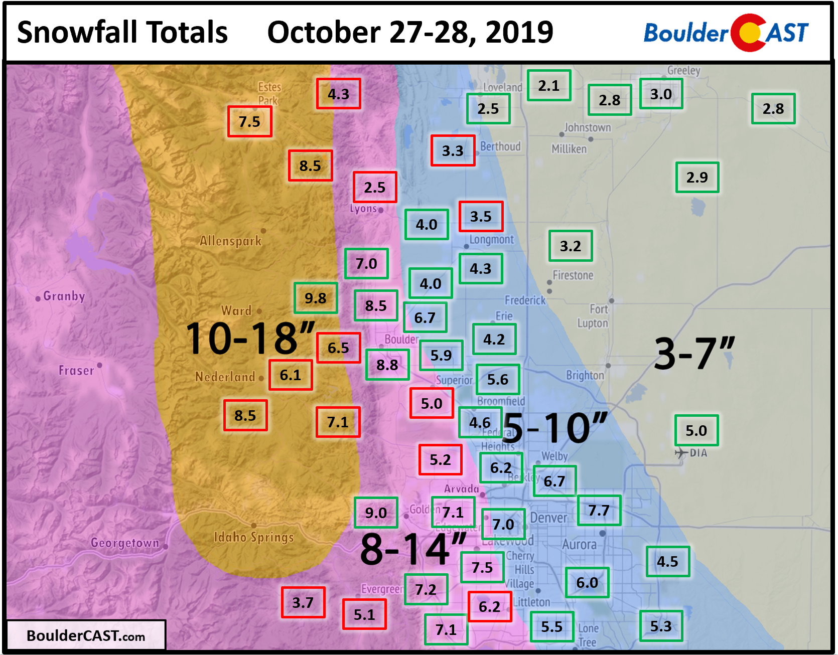
The snowstorm itself played out about as expected, though the arrival of the banded snow was slightly later than we were anticipating. The snow bands related to the passing jet were also more dispersed and weaker than forecast. The net result was an okay forecast for most of the lower elevations, but disappointing totals in the Foothills which came up well short. Though we had significant concerns about the lack of upslope with this system in our area (which verified), the models painted plenty of moisture focused across the higher elevations west of the Denver Metro area. With almost no upslope beyond the surface, this modeled pattern was misguided and we should have totally disregarded it. Another reason we forecasted the higher totals in the Foothills was due to higher snow ratios, but ultimately the lack of deeper upslope really hurt areas like Nederland, Estes Park, and Evergreen. Only about 4 to 10″ of snow fell in the Foothills, more or less the same as across the Plains.
Shown below is our snowfall forecast map issued Saturday evening with actual storm totals overlaid in boxes. Green boxes indicate that our forecast verified to within one inch of the observed snowfall. Red did not.
Though light snow continued to fall across the area after the reports, the official total in Boulder was 8.8″ with a fluffy snow-to-liquid ratio of 19:1. Don’t even waste your time trying to build a snowman today….it is futile! Boulder’s official observations are taken behind the NIST Building off South Broadway (location shown below). Denver’s official snow observation today from DIA is around 4 to 4.5″, just enough to cause a slew of flight delays and cancellations.

The official Boulder climate station near the NIST building in South Boulder. Photo credit: Matthew Kelsch
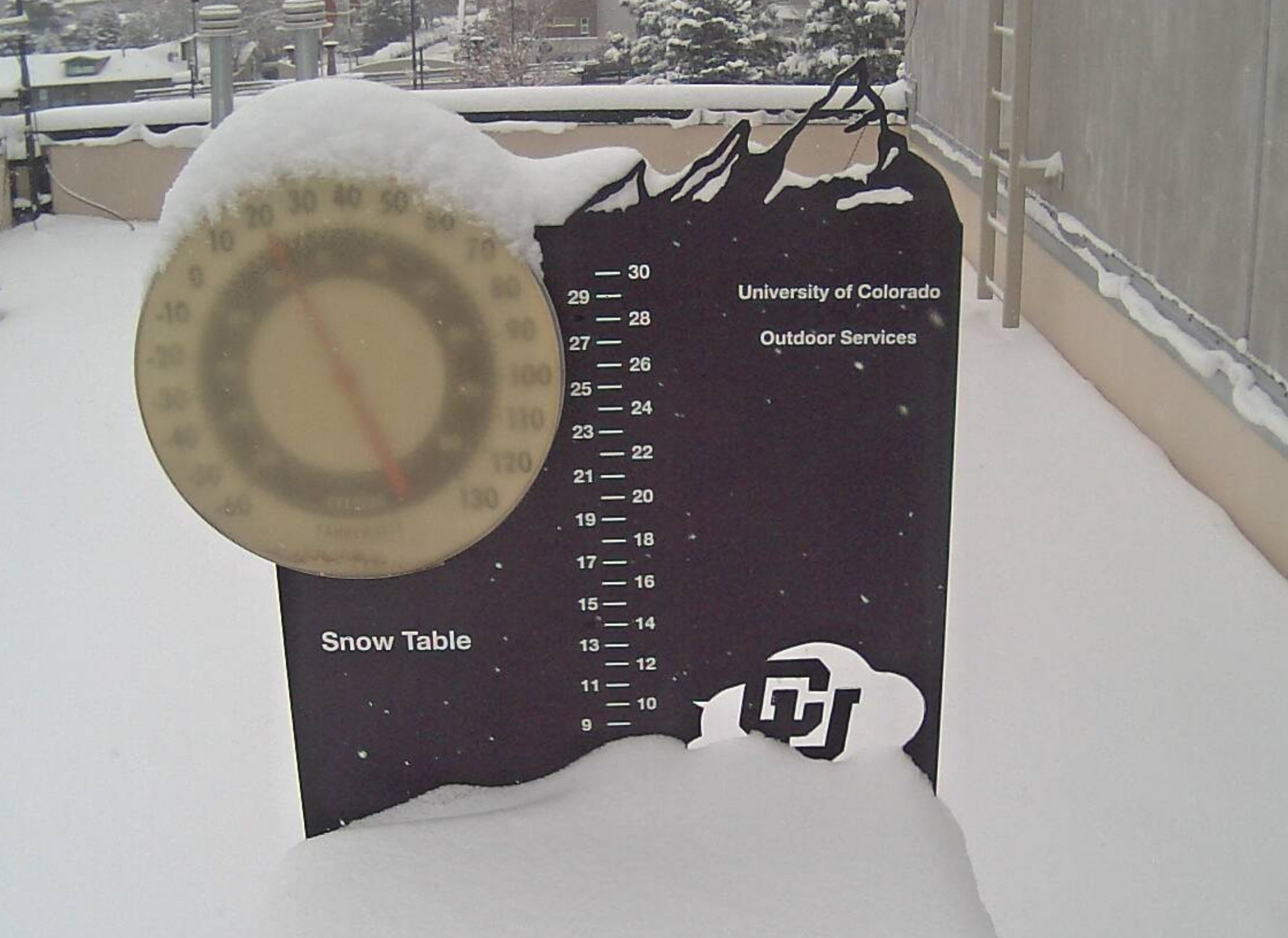
Just a quick reminder: All forecasts are for snowfall accumulation, not snow depth. For long-duration snowfall events such as this one, gravity will compact fresh snowfall over time and there also may be some melting. This leads to snowfall totals being slightly higher than snow depth (what’s actually on the ground). Official snowfall measurements are taken on an elevated surface that is cleared once every six hours. It may seem strange, but this is the standard procedure. You can read more about official snowfall measurement guidelines here. For example, despite a snow total of 8.8″ in Boulder today, there is only around 7 to 8″ on the ground. The CU Boulder snow table had just over 8″ of snow depth around 8:00 AM this morning. This table was NOT cleared every six hours during the storm.
Here is where Boulder and Denver stand currently for seasonal snow amounts. This has been Boulder’s 4th snowiest October on record (last 130 years). We could push to number one with our next storm on Tuesday…we ONLY need about 10″ more!
| Seasonal Snow Totals (Updated Oct 28 2019) |
|---|
| Boulder | Denver |
|---|---|
| 19.6" | 4.8" |
ARCTIC BLAST PART TWO:
Snow returns quickly Tuesday morning
ust like the first wave of snow, the second will be another long duration event accompanied by an even colder airmass. In fact, the incoming snow storm is rather similar to the departing one with almost an identical track. Both storms are shown in the 500 mb height and vorticity animation below from the GFS ensembles, one after another. Can you see the surprising similarities?

GEFS mean 50 0mb height and vorticity animation showing the prior and upcoming storm systems moving through.
Despite all of the likenesses as it arrives, we’re not convinced Tuesday’s snow event will play out exactly the same as Sunday night’s….the devil is always in the details for our area thanks to complex topography!
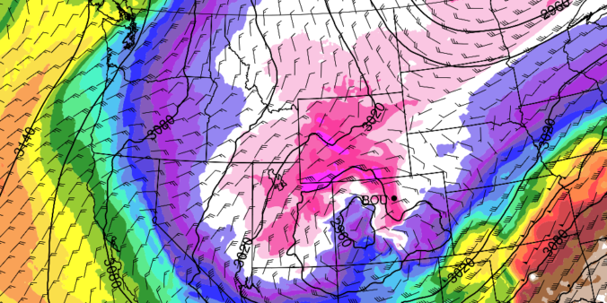
A key factor we are currently concerned about is the potential for upslope versus downslope. Will upslope be another no-show like our last event (this is what the GFS model is predicting; below on left) or will it be as suspiciously strong as the NAM model is currently indicating (below on right). If the 20 to 30 mph easterly winds indicated by the NAM model come to fruition, most areas in the Front Range would see at least 8 to 12″ of snow. As you can see in the panel on the left, the best easterly upslope from the GFS is across southeast Colorado.

Forecast 700 mb temperatures and winds for Tuesday evening from the GFS (left) and NAM (right) models.
So what’s up with the NAM model? Well, for one, the NAM is currently forecasting the strongest intensity as the system moves across Utah into Colorado Tuesday night. A stronger, more tightly-wound storm will have more intense winds. Because there is such good agreement among the other models, we’re not inclined to side with the NAM at this time, though it does spread to top-end potential for snow amounts with this system a little higher than we’d like.

Forecast 500 mb heights for Tuesday night at midnight from four different models. There is general agreement on the position and intensity of the storm.
Furthermore, we’re beginning to sniff-out some potentially concerning small-scale wind effects leading to low-level northerly or northwesterly winds across the area Tuesday evening and Tuesday night. Surface winds with any westerly component are concerning, especially for northwest portions of the Metro area, including Boulder. The primarily northerly winds would also dampen snow potential around Fort Collins, Loveland, and Longmont due to downsloping effects from the Cheyenne Ridge. This will be a problem for most of the event.

NAM 800 mb temperature and wind forecast for Tuesday night. North/northwest winds around Boulder could be bad news!
Can you pick out the sense of rotation in the wind barbs just east of Denver in the NAM 800 mb map above? We see the same pattern almost akin to a Denver Cyclone, in the HRRR model as well (see below). Heavy snow is likely to be focused around this area of low-level convergence where “warm” and moist southeasterly flow will be overrunning the colder and denser Arctic air over Denver and Boulder. With this in mind, the lucky location where this develops could see more than a foot of snow as the entire system is slow-moving. For now, we think the best odds of this would be east of Denver out across the Plains of eastern Colorado. If this convergence shifts further west in the upcoming model runs, all bets are off!
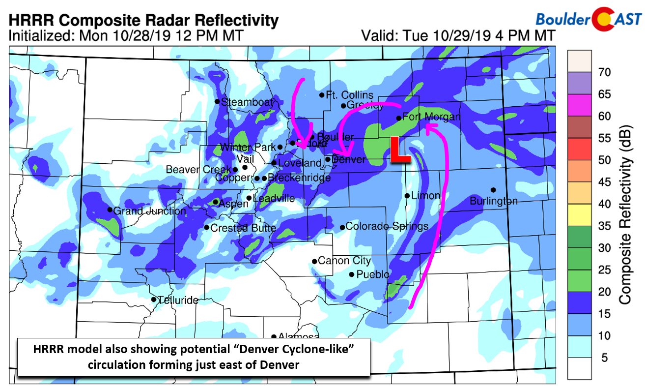
HRRR model simulated radar reflectivity for Tuesday early evening
Another issue with our next snow-maker is the position of the overhead jet stream: it’s just too far south. There isn’t a single model that supports much jet-forcing across the Boulder and Denver areas. At worst, we could foresee a small amount of activity Tuesday afternoon for areas south of Interstate 70 and east of Interstate 76. Boulder probably misses out on this jet entirely.
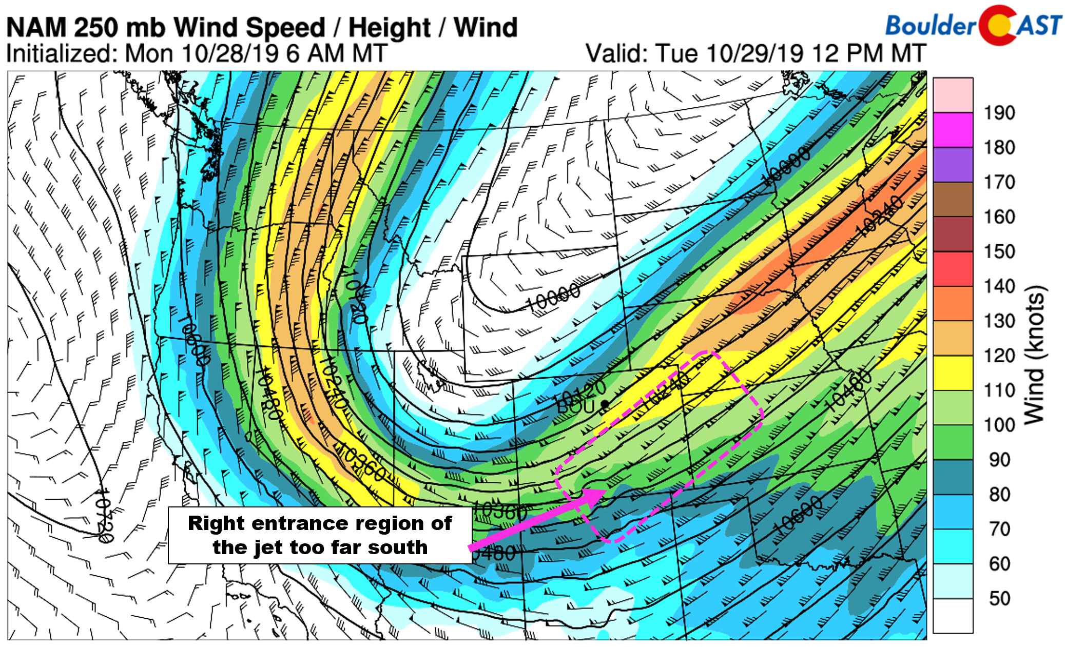
NAM 250 mb wind forecast for Tuesday afternoon. The best jet forcing is further south
Finally, we end with some good news! The very cold Arctic airmass will lead to very high snow-to-liquid ratios once again for the area. Our algorithms are showing values between 16:1 and 20:1 region-wide. Fluffier snow can really add up!
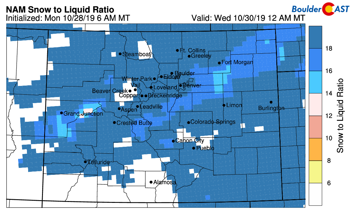
NAM model-derived snow-to-liquid ratio forecast for Tuesday evening
Preliminary Snow Amounts:
First, we preface by reminding you that the snow totals we are forecasting won’t drop immediately. This covers snow falling from Tuesday morning into Wednesday late morning or early afternoon. This is another LONG duration snow event. What you see on the ground will likely be a little less than what has actually fallen!
Second, we continue to stress this is a very difficult forecast for a number of reasons. Model differences surrounding small-scale wind influences are the biggest concern and overall will be tricky to pinpoint until things begin cranking Tuesday morning.
We believe that strong upslope initially behind the front will boost totals across the Boulder area during the morning and afternoon. Later in the day, the best large-scale lift will arrive to other portions of the Metro area, too. This will spread the more intense snowfall south and eastward as the area north and west of Denver shifts into a downslope regime. The net result will be relatively well distributed snow totals region-wide. This is reiterated by our latest Snowfall Probability Charts which show almost identical percentages across Boulder, Denver and the higher elevations. That is, a very good chance of 6″ of snow, but almost no chance to exceed 12″. We even see a rare situation where Denver actually has higher chances of reaching 8″ than Boulder. This stems from the potential downsloping Tuesday evening and night.

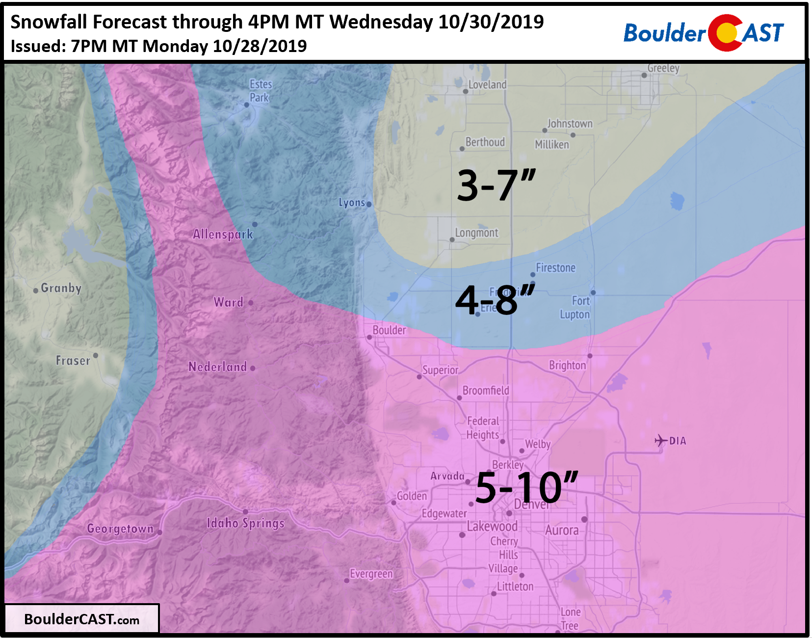
With this, our snowfall forecast map for snow falling Tuesday morning into Wednesday afternoon is shown below. Remember, this will be a long-duration event with nearly continuous snow possible for 24 to 30 hours!
A Note on the Very Cold Air
In contrast to the snow, the frigid air is an easy forecast this week. Expect single digit lows or lower teens the next few nights and highs only in the mid to upper teens Tuesday and Wednesday. The absolute coldest temperature should occur early Thursday morning when record lows could be broken with clearing skies and fresh snow on the ground to boost radiational cooling. Overnight lows could drop close to zero degrees at this time, borderline new MONTHLY records for just about every Front Range city. The duration and magnitude of cold stretch is nearly unprecedented in our area during the month of October! We’ll discuss this more after the dust settles…
Clif Notes Forecast:
- A second slow-moving winter storm will impact the entire Front Range from Tuesday morning into Wednesday afternoon
- To kick things off, an Arctic front will move in just after sunrise Tuesday with snow developing quickly thereafter. Snow will persist through much of the day Tuesday, especially north of Denver.
- The heaviest snow is expected to develop during the morning in Boulder and later Tuesday afternoon in Denver and continue well into Tuesday night. Travel conditions will deteriorate in the heavier bands
- Snowfall amounts are relatively uncertain for a number of reasons, but in general, we expect 4 to 10″ across the Boulder/Denver area
- The Tuesday morning (in some areas), Tuesday evening and Wednesday morning commutes will be highly impacted. Plan accordingly!
- Record cold will intensity and continue from Tuesday through Thursday morning with highs in the teens and lows in the single digits. Many areas will approach all-time record lows for the month of October
Stay tuned for updates as the cold and snowy weather will be with us through Thursday morning! Subscribe to BoulderCAST to get instant email notifications when our new forecasts go live, and don’t forget to follow us on Facebook or Twitter.
We discuss Boulder and Denver weather every single day on BoulderCAST Premium. Sign up today to get access to our daily forecast discussions every morning, complete six-day skiing and hiking forecasts powered by machine learning, access to all our Front Range specific weather models, additional storm updates and much more!
.
Spread the word, share the BoulderCAST snow forecast!


You must be logged in to post a comment.