
We’re not going to beat around the bush. A complicated forecast is developing for the next several days that will bring two different snowstorms to the Front Range intermingled with potentially the coldest airmass ever to take hold of northern Colorado during the month of October. In this forecast update, we primarily discuss the first part of the storm that will produce snow across the area Sunday morning into Monday morning.
UPDATE (7:00 PM Sat 10/26/19): Added our official snowfall forecast map to the end of the post!
PREMIUM UPDATE (3:00 PM Sun 10/27/19): Read HERE.
We discuss Boulder and Denver weather every single day on BoulderCAST Premium. Sign up today to get access to our daily forecast discussions every morning, complete six-day skiing and hiking forecasts powered by machine learning, access to all our Front Range specific weather models, additional storm updates and much more!

B
efore things take a drastic turn later night, we have one more pleasant day in the forecast for your Saturday with highs in the lower 70’s and partly sunny skies. Knock-out those outdoor activities if you can; you won’t want to be doing them on Sunday (or any day next week, for that matter)!
The first storm of concern is already dipping southward through western Montana and Idaho this morning. Watch as the elongated trough drops southward through Colorado by Sunday night in the 500 mb forecast animation below.

GFS 500 mb height anomaly forecast animation from Saturday morning through Monday evening
The associated very strong cold front will push into the Front Range later this evening, slamming through the Boulder/Denver area between 6:00 and 9:00 PM. Expect an abrupt drop in temperatures and gusty winds to accompany the front.

NAM 800 mb temperature and wind forecast Saturday night at midnight
On the back-side of the cold front, moisture will slowly increase with temperatures falling to the 30’s and eventually the 20’s by sunrise Sunday. Initially, the gradual cooling, shallow upslope and shallow moisture will likely develop fog and drizzle during the overnight hours across the lower elevations before fully-changing over to snow Sunday morning as deeper, colder air arrives. Once this change-over happens, it will be ALL SNOW the rest of the week, for better or for worse. There could also be a brief period of freezing drizzle for several hours leading up to sunrise Sunday, so do be aware of potential black ice. Temperatures during the day on Sunday will hold in the upper 20’s to near 30 degrees.

HRRR model precipitation type for 2AM Sunday morning showing mixed precipitation across the Front Range
With this first storm on Sunday, upslope isn’t a major player. While a closed-low will get “pinched-off” over western Colorado (see below), the resulting wind fields do not cooperate across our area.

GFS 700 mb temperature and wind forecast amp for Sunday evening
Zooming in closer on just Colorado Sunday evening, we see good agreement overall between the GFS and NAM models in regards to the position of the low pressure system, the temperatures, and (unfortunately) the meager and disorganized winds across the Front Range. Speeds of only 5 MPH are indicated at ~10,000 feet elevation, and it could be downslope or upslope. This lack of upslope will be a limiting factor on snow amounts.

700mb temperature and wind forecast map for Sunday evening from the GFS (left) and NAM (right)
Fortunately, though, upslope isn’t the only game in town. We also have a large 150 MPH jet streak that will be draped from the Four Corners into the Great Lakes during this time. Unlike the snow event a few days ago, this jet will be very slow to sag southward across the area on Sunday and with much of the state landing in the favorable right-entrance region of the jet. This should help to enhance snowfall intensity Sunday evening and night, especially across the northern Mountains and Foothills. The jet will also be pumping plenty of juicy Pacific moisture into Colorado.

GFS 250 mph wind forecast throughout Sunday and Sunday night. The region of enhanced jet lift is boxed in pink in each graphic.
We also must consider that through Sunday and especially Sunday evening and night, conditions will be primed for dendrites to form in the atmosphere aloft, a very voluminous type of snow crystal. A deep saturated layer of ideal temperatures will be co-located with strong instability and the lift from the jet. This will produce extremely fluffy snow with ratios above 15:1 and probably near 20:1 in the Foothills.

NAM model-derived snow to liquid ratios Sunday night
With all of the factors coming together, continuous snow will be falling in most locations through the day Sunday and into Sunday night. It will initially be light snow that may have a hard time accumulating given the warm ground temperatures and daytime solar influx. However, as the better lift arrives later Sunday, snowfall intensity will increase region-wide with also elevated chances for embedded heavy snow bands from the jet through much of the late afternoon and evening.
The first wave of snow will come to an end Monday morning with sunshine taking over by afternoon. A very chilly airmass will remain, so don’t expect any real warm-up. Highs should get into the 20’s on Monday and then fall into the single digits Monday night. It only gets colder from there!
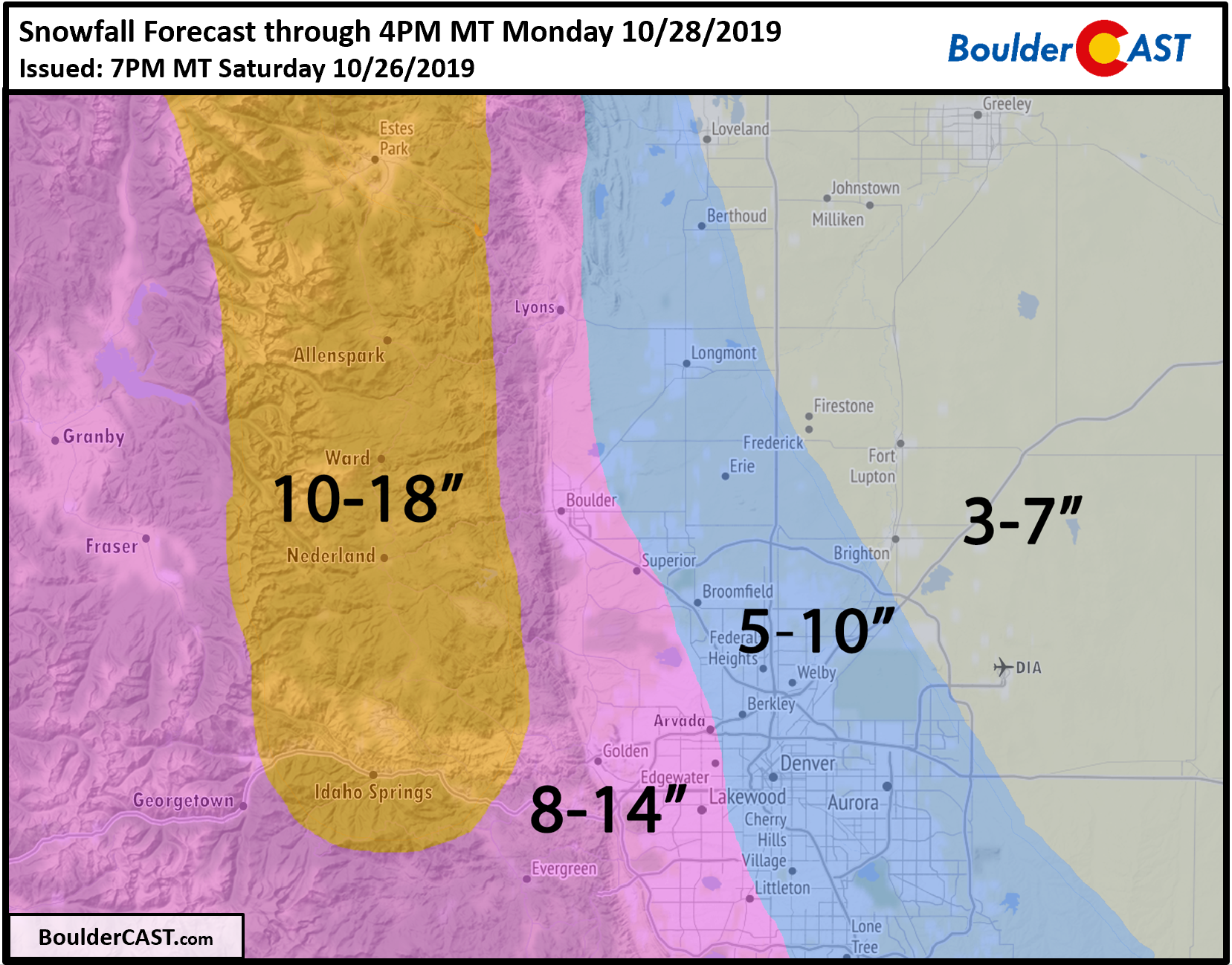
So how much snow are we expecting from the first wave? Considering that Arctic air will be clashing head-on with Pacific moisture during a prolonged period of jet forcing AND the unseasonably high snow-to-liquid ratios, amounts will be significant across the Front Range. We still have some lingering concerns about the upslope situation, but enough factors are boosting snow totals that we don’t believe the lack of deeper upslope will matter all that much.

Our snowfall forecast map below covers snow falling from Sunday morning through Monday afternoon. Most of this accumulation will fall Sunday afternoon into early Monday morning.
Stay tuned for updates as the cold and snowy weather will be with us through Wednesday. Subscribe to BoulderCAST to get instant email notifications when our new forecasts go live, and don’t forget to follow us on Facebook or Twitter.
We discuss Boulder and Denver weather every single day on BoulderCAST Premium. Sign up today to get access to our daily forecast discussions every morning, complete six-day skiing and hiking forecasts powered by machine learning, access to all our Front Range specific weather models, additional storm updates and much more!
.
Spread the word, share the BoulderCAST snow forecast!


You must be logged in to post a comment.