
As advertised, Wednesday night’s winter storm was a quick-mover! From the first snowflakes to the last ones, only about eight hours elapsed as the tightly-wound storm passed across Colorado. What it lacked for in duration, it made up for in intensity…in some areas. We take a look at the highly-variable snow totals from across the Boulder and Denver area and provide a brief post-mortem on the now-departing storm system.
As we detailed in several forecast updates leading up the storm, a large gradient in snow was expected across the Metro area with the highest totals south and west of Denver tapering off to virtually nothing northeast of the city. The reasons for this predicted gradient were two-fold:
- The track of the storm brought the best large-scale lift just south of us, only really clipping the south and southwest portions of the Metro area for a short time Wednesday evening
- A Four Corners low pressure briefly “pinched” off in southwestern Colorado helping to intensify northeast upslope winds into the Front Range late Wednesday evening into the wee-morning hours Thursday. It’s a shame that this Four Corners low couldn’t stick around longer than a few measly hours. This is the exact set-up which has produced some of the biggest autumn snowstorms in Boulder’s history!

NAM 700mb temperature and wind forecast map for midnight Wednesday night
During the afternoon and early evening Wednesday, a few pockets of banded precipitation did form across the Metro area just before the overhead jet stream rapidly scooted to the south. Unfortunately, temperatures were too warm during this time, with most of this precipitation falling as rain showers or very wet snow that melted.
The entire radar animation from last night is shown below. Pay particularly close attention to how the entire shield of snowfall was focused to the south and west across our area. As the aforementioned influx of deeper upslope arrived around 9:00 PM Wednesday evening, snowfall intensity soared in the western suburbs and Foothills while temperatures cooled allowing for fluffier snow ratios.

Radar animation covering Wednesday evening and night
With the atmospheric set-up clear as day, our forecast called for bigger totals across the western and southern portions of the area, while locations further north and east were expected to see almost no snow. Shown below is our snowfall forecast map issued Wednesday morning with actual storm totals overlaid in boxes. Green boxes indicate that our forecast verified to within one inch of the observed snowfall. Red did not.
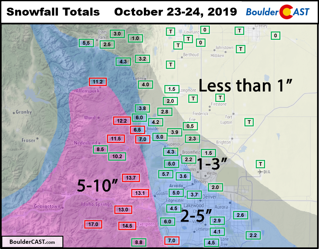
- The official snow total in Boulder was 7.0″ with a liquid amount of 0.54″. This translates to a snow ratio of ~13:1 (considering there was some rain near the onset)
- 3 to 4″ fell near downtown Denver
- Denver International Airport officially reported just a Trace of snow… 🙁
- BOOMING snowfall totals occurred across the Foothills of Boulder and Jefferson Counties with 8 to 14″ observed and snow ratios ~17:1. We knew this area would be the hardest hit last night; we just didn’t expect quite THAT much snow!

Snow table at CU Boulder around 6:00 AM Thursday morning with 5 to 6″ of snow.
| Seasonal Snow Totals (Updated Oct 24 2019) |
|---|
| Boulder | Denver |
|---|---|
| 10.8" | 1.0" |
The next few days will be quiet across our area with sunny skies and a warming trend through Saturday when we could push into the 70’s! Our next chance of winter weather comes quickly, Saturday night and Sunday as another storm drops south out of Canada. At this point, it looks weaker overall but also slower-moving. This net result should translate into another round of moderate snow accumulations across the Denver Metro area. In addition, the airmass drawn southward on the back-side could be very much winter-like with potentially record cold for the month of October. The models are in poor agreement right now on the exact magnitude of the frigid airmass, but overall agree on its presence in eastern Colorado to close out the month.

Subscribe to BoulderCAST to get instant notifications when our new forecasts go live. Have a good end to the week!
.
Share this post:
.


You must be logged in to post a comment.