Right on schedule, a series of heavy snow bands progressed across the Front Range Thursday morning producing the season’s first snow for everyone alongside record cold temperatures. We take a look at snow totals and the impressive temperature records from across the area. We also announce the winners of our 2019 First Snow Contest.
Season’s First Snow: ✔️
Record October Cold: ✔️
Ready for Summer: ✔️
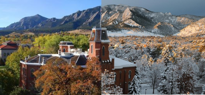
For the second year in a row, the inaugural snow of the season in Boulder happened on October 10th, about ten days earlier than normal. This isn’t true for Denver, however. If you recall, a strange “first snow” scenario last year led to the first ever occurrence of Denver reporting snow earlier in the season than Boulder. Nonetheless, everyone notched their first snow THIS year on Thursday!
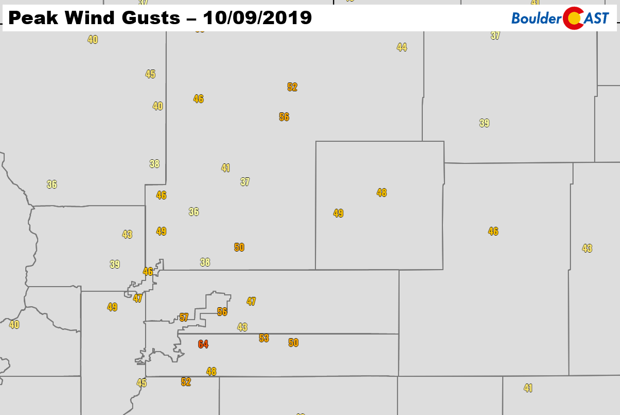
It’s seems so very long ago, but we were indeed resting comfortably in the upper 70’s to lower 80’s on Monday, Tuesday, and Wednesday earlier this week. Any feelings of summer were quickly vanquished around 4:00 PM Wednesday evening when a powerful cold front dropped into the Metro area. As the front moved through, gusts in excess of 50 MPH were reported along with blowing dust. We warned you this front would be a doozy! Peak winds gusts from Wednesday evening are shown below.
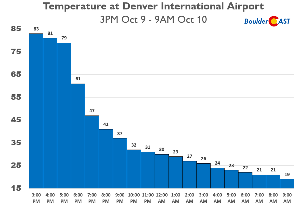
As the front passed, the immediate drop in temperature was extremely noticeable with some cities plummeting more than 40 degrees in just four hours. The graph below shows temperatures at Denver International Airport where a record-setting 64-degree temperature drop was recorded in only 18 hours Wednesday evening into Thursday morning. A similar change of around 60 degrees was observed in Boulder.
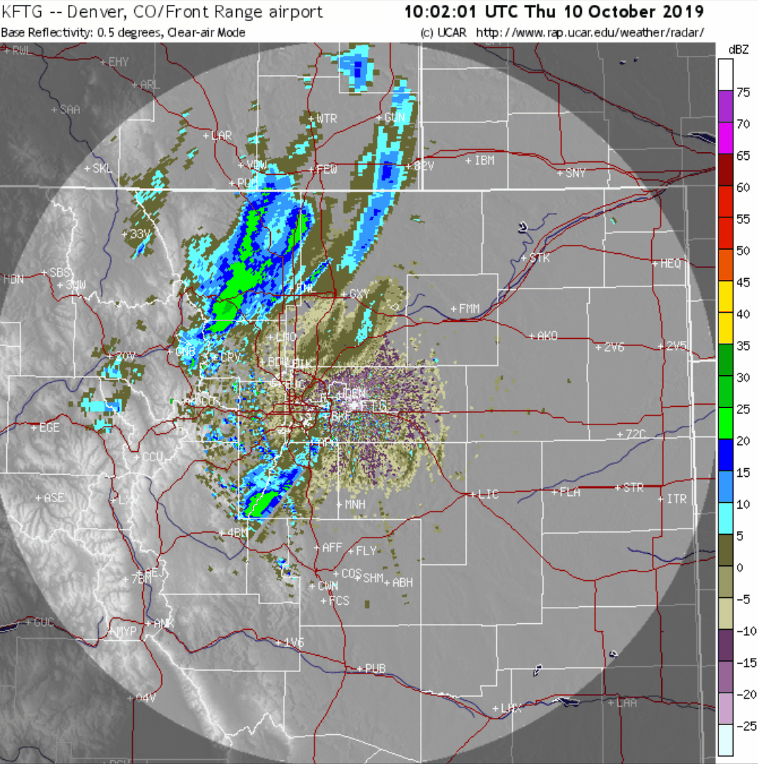
Just as we forecasted, accompanying the bitter cold were a series of moderate to heavy jet-forced snow bands which rolled off the Foothills just in time for the Thursday morning commute. The radar image below is from 6:30 AM on Thursday. The northwestern portion of the area was first in-line for heavy snow. Boulder had 2″ on the ground before areas like Parker had even a single flake.
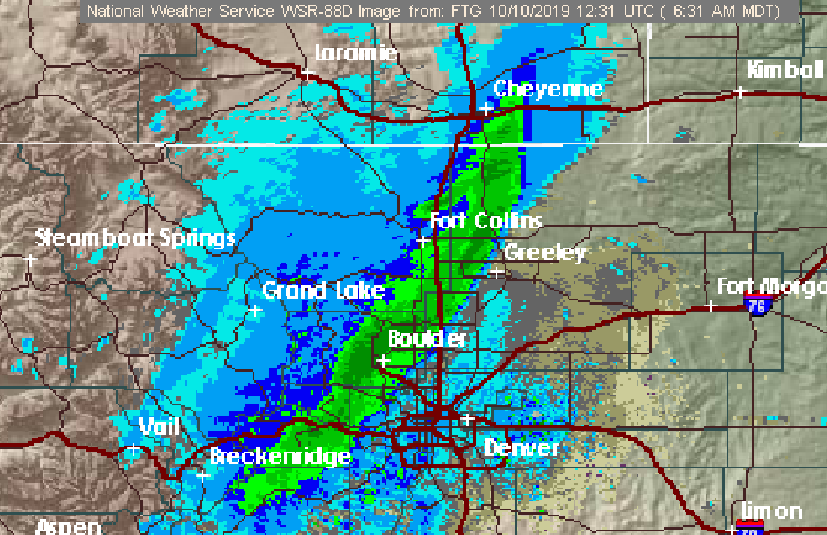
Radar image from 6:30 AM on Thursday just as the snow commenced
As the morning progressed, the initial heavy snow band pushed eastward and was later joined by a few friends over the heart of Denver. Despite the very warm temperatures the days prior, snowfall rates of 1 to 2″ per hour in these bands led to slick snow-covered roadways. The snow literally couldn’t melt as fast as it was falling. As a result, more than 300 car accidents were reported Thursday morning around the Metro area. The full radar animation from the day is shown below.
Radar animation from Thursday at 4AM to 2PM
The actual storm system responsible for the frigid temperatures and our first snow was located way to our north along the Montana and Wyoming border, never getting closer than 400 miles to Denver. This distant track produce a low-level wind field almost due northerly across the Front Range. This of course is NOT upslope for most of us. However, as we discussed in our forecasts leading up to the event, this didn’t really matter as the primary forcing was the jet stream. It took a meandering dive into the Four Corners region Wednesday night. This put northern Colorado in a region of strong, linear lift which spawned the heavy snow bands Thursday morning.
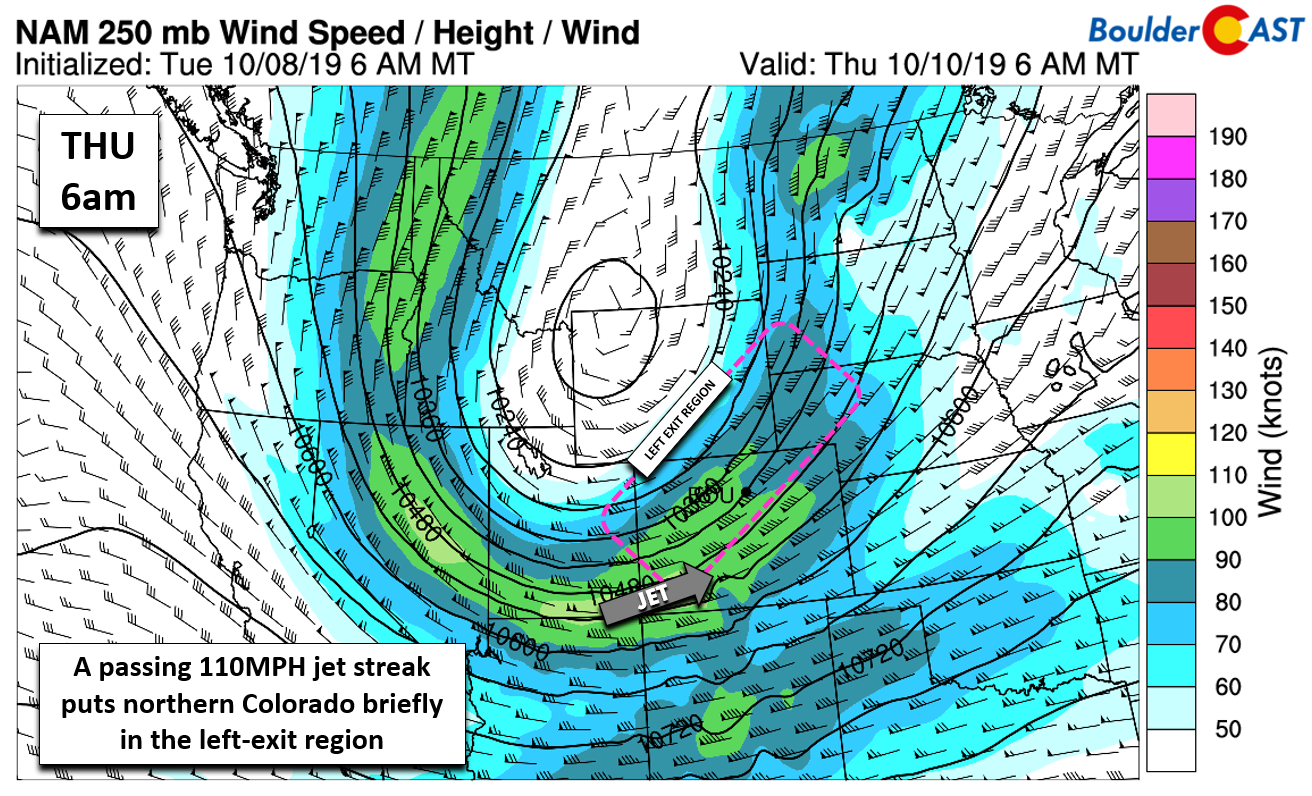
NAM 250 mb wind forecast for Thursday morning showing the position of the jet and the favorable location of northern Colorado in the left-exit region
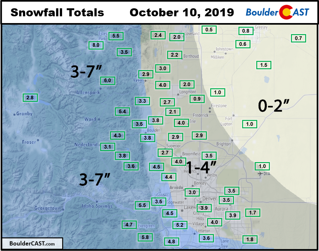
With a lack of any real upslope (or downslope), the limiting factor for snowfall amounts on Thursday was purely the brevity of the favorable lift across the area. The overhead jet weakened and exited eastern Colorado just as quickly as it arrived. Heavy snow bands were only present from about 6:00 AM to 11:00 AM and tended not to linger in any one location more than an hour or two. All in all, this led to a complete verification of our snowfall forecast across the entire area. Boulder managed to pick up 3.8″ of snow. Denver officially reported 1.0″ at DIA, though more like 3 to 4″ fell near Downtown. Thankfully, snow totals stayed just below the threshold to cause any significant tree damage.
Shown below is our snowfall forecast map issued Tuesday evening with storm totals contained in boxes. Green boxes indicate that our forecast verified to within one inch of the observed snowfall. Red did not (there are no red).
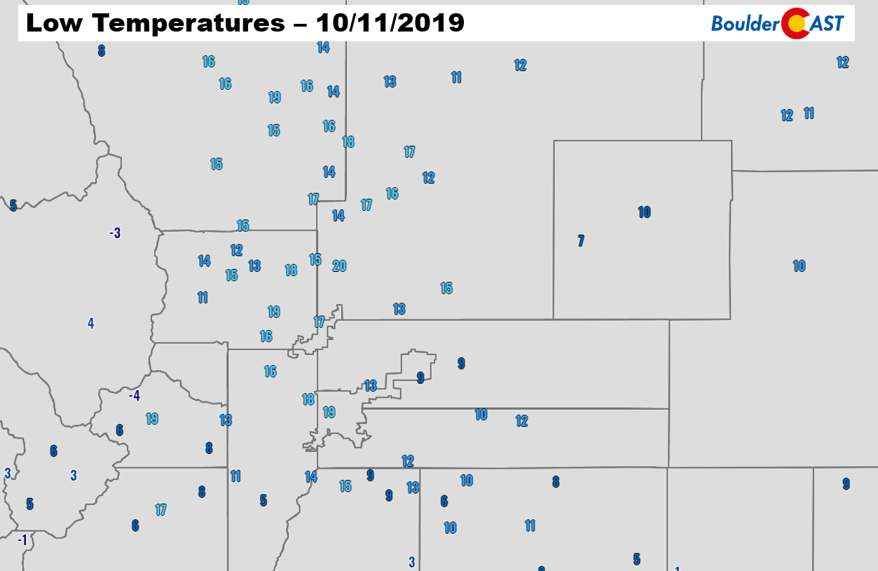
In addition to the snow, cold temperature records of all flavors were set across the board. Denver etched a new record low on both Thursday and Friday, bottoming out at just 9 degrees early this morning. This is potentially the earliest single digit temperature reading ever in Denver. Boulder set a new record low for today as well, reaching 15 degrees which destroyed the prior record of 20 degrees. The 36-hour tumble from 83 degrees to 9 degrees in Denver is also new record. Just about everyone dropped into the teens both nights, with some single digits and even below zero temperatures in the Mountains.
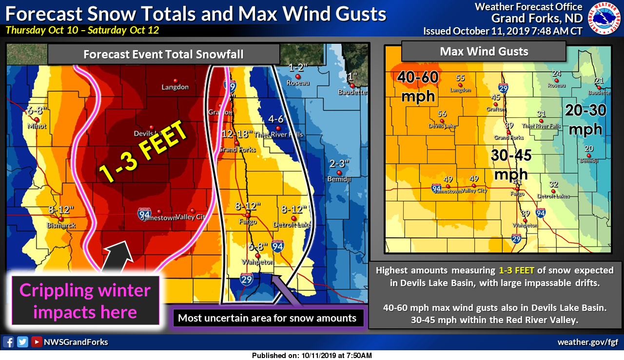
Despite how it may seem, Colorado got off fairly easy from this powerful storm system. States closer to the center of the low are experiencing up to 3 feet of snow and strong winds creating blizzard conditions and impossible travel. Here is a recent forecast graphic from the National Weather Service in Grand Forks, North Dakota. All we can say is wow!
For once, it’s not our area headlining the national news due to early-season snowstorms, though apparently our snow did make national news in some capacity as many friends and family reached out about the snow and extreme cold impacting Boulder this week.
Things are already looking up for the Metro area! The sun is shining, the snow is melting, and temperatures will return into the 40’s this afternoon. That sunshine and a warming trend are expected to continue into the weekend…
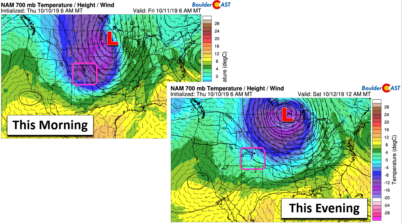
NAM 700 mb temperature and wind forecasts for Friday morning (left) and evening (right). The cold airmass quickly heads away from the Front Range
| Seasonal Snow Totals (Updated Oct 11 2019) |
|---|
| Boulder | Denver |
|---|---|
| 3.8" | 1.0" |
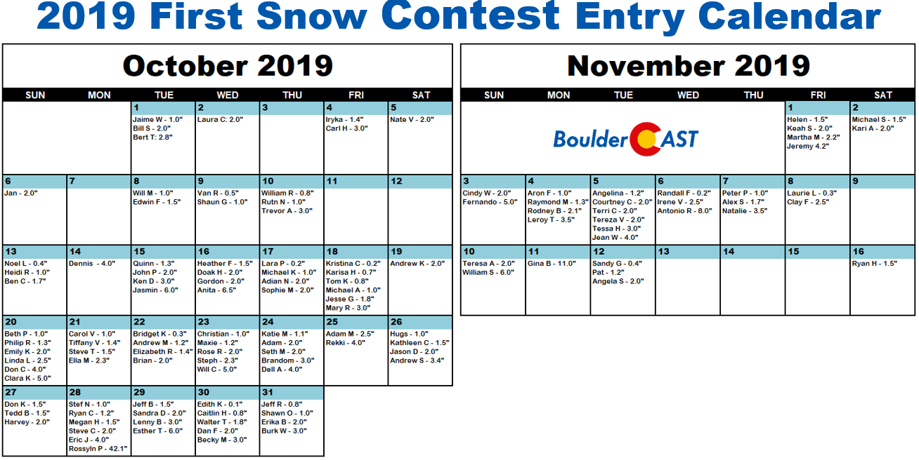
Congratulations to the winners of our 2019 First Snow Contest
There were more than 120 entries into the contest this year. Here are some facts about the predictions:
- Dates ranged from October 1st to November 16th
- Amounts ranged from 0.1 to 42.1 inches
- The mean and median date of the guesses were October 24th. This is three days later than climatology.
- The winner predicted the correct date but was off by 0.8″ on the amount
- Two other folks guessed the exact date correctly as well
The verification of Boulder’s first snow was October 10 and 3.8″.
Congratulations to the winners detailed below. You will receive an email with further instructions in the next few days.
- 1st place: 12-month Premium subscription + $25 Amazon Gift Card
- Trevor A: Oct 10 – 3.0″
- 2nd place: 6-month Premium subscription
- Ruth N: Oct 10 -1.0″
- Anyone who guessed within 1 day OR 0.1″ correct: 2-month Premium subscription
- William R: Oct 10 -0.8″
- Shaun G: Oct 9 – 1.0″
- Van R: Oct 9 – 0.5″
- All other entries: Virtual “pat on the back”
- 121 other people
If you didn’t win, don’t worry. We’ll definitely host more weather-related contests periodically throughout the year.
.
Share this post:
.


You must be logged in to post a comment.