*THIS CONTEST HAS CLOSED TO ENTRIES*
Are you eager for the first snow of the season? Have you already waxed your skis and purchased your Epic Pass? Our first big snow could be right around the corner! We provide a brief overview of Boulder’s first snowfall climatology, discuss the snowfall forecast for the next ten days, and then pose a question…“When will Boulder’s first measurable snow occur this year?” Submit your guess for not only a chance to win recognition among local weather enthusiasts, but prizes too. Those who get closest to the date of our first snow win. Read on for all the details.
First snows of Boulder’s past
September weather is often a bit of a mix bag in the Denver Metro area. Our first snow of the year can and often does occur, but we’ve also seen historic flooding and lengthy heat waves. Hard to believe, right? This is the nature of the business during the transitional months in Colorado. At this point, now at our 9th consecutive 90-degree day, we know you’re tired of the summer heat and just want to jump straight into winter. Let’s briefly review some statistics of Boulder’s annual first snowfall. Hopefully this will give you some context for your contest entry to follow.
The chart below shows the date of Boulder’s first measurable snowfall for each year dating back to 1950. Measurable means that officially 0.1″ or more of snow was recorded. As is often the case early in the snow season, a few flakes mix in with rain, or flurries briefly fly, but never stick to the ground. These are instances where a trace of snow has occurred, but wasn’t measurable. For the purposes of the contest, we don’t care about these non-measurable snowflakes.
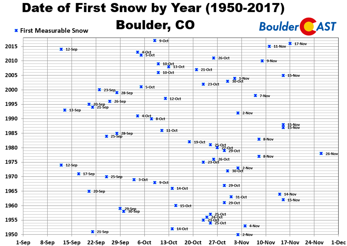
CLICK TO ENLARGE
You can see there is a huge variation from year-to-year in the date of our first measurable snowfall. The earliest was September 12, 2014, with 0.5″ of snow falling. The latest measurable snow was November 26, 1978. That’s a spread of nearly three months! The normal (median) date of our first snow is October 20th.
How about a few percentiles for the gamblers out there? The odds of our first measurable snowfall occurring on or before…
- September 20th: 10%
- October 1st: 25%
- October 20th: 50%
- October 31st: 75%
- November 10th: 90%
These numbers work out nicely and equate to our first measurable snowfall occurring in September 25% of the time, in October 50% of the time, and in November 25% of the time.
As you might imagine, our first snow event each year is usually a small amount…providing only an introductory taste of winter. The histogram below shows that 37 years since 1950 had an inaugural snowfall less than 2.0″ (54% of the time). Boulder’s first snow only exceeded 6.0″ on 8 occasions (12% of the time). The average amount of Boulder’s first snow is 3.0″, while the median amount is 2.0″.
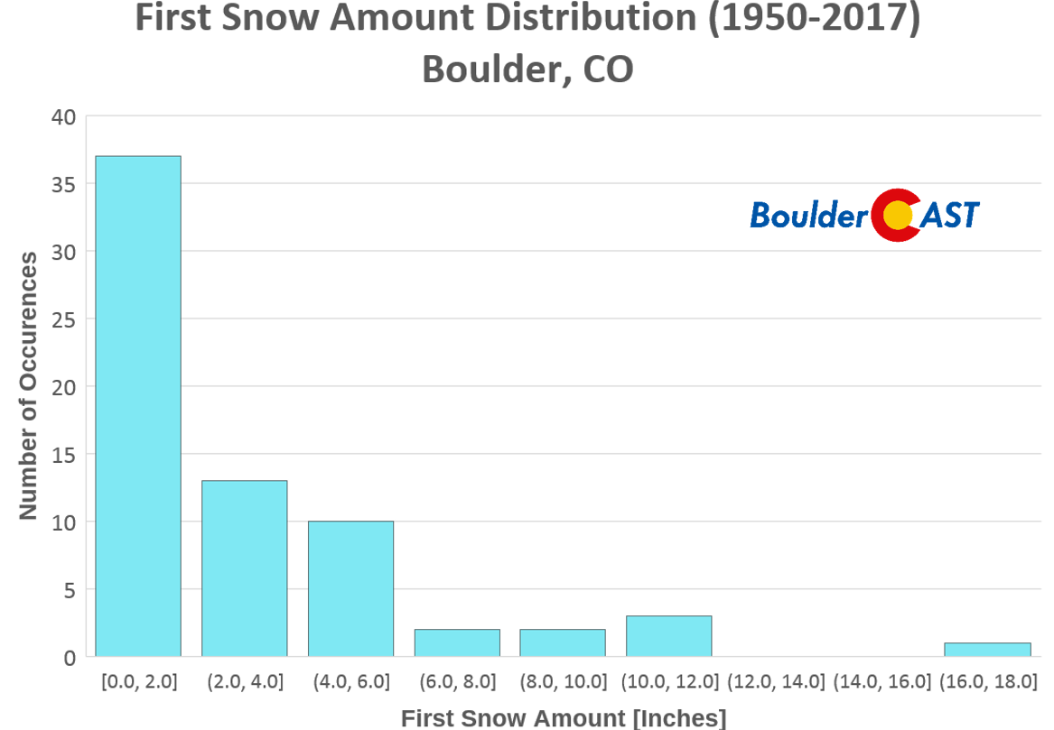
Histogram of Boulder’s first snow amounts since 1950. The side shows the frequency of occurrence, while the bottom axis has intervals of snowfall amounts in inches
Snowfall outlook for the next 10 days
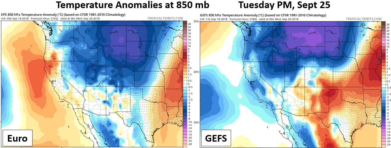
With that brief history lesson complete, let’s discuss the possibility of snow in the near-term. How exciting! Taking a look at the last several runs of the GFS and the European models, we’re not seeing anything that suggests snow is possible in Boulder through September 24th. Colorado is poised to remain mostly dry with temperature near or slightly above normal through the beginning of next week (save for some rain showers Wednesday night).
This time of year, so early in the season, just about the only way snow can happen on the Front Range Plains is if an epic trough develops across the western United States, spawning a cut-off system that funnels extremely cold air southward east of the Rockies along with some upslope. While the next week will be rather quiet and summer-like for our region, things are looking more interesting around the middle of next week in the September 25-27 timeframe. Yes, this is seven days out in the models and of course is fairly uncertain, but there is believable agreement for a major pattern shift with the potential for much colder temperatures and even an outside chance of our first snow. Both the GFS and European runs and ensembles are showing this potential as a relatively big trough digs across the central Rockies. The below 500 mb height anomaly forecast is from the latest GFS run for next Wednesday (Sept 26th). In this particular forecast, the trough would bring fall-like temperatures and precipitation to the Front Range, but probably would be too warm for snow across the lower elevations.
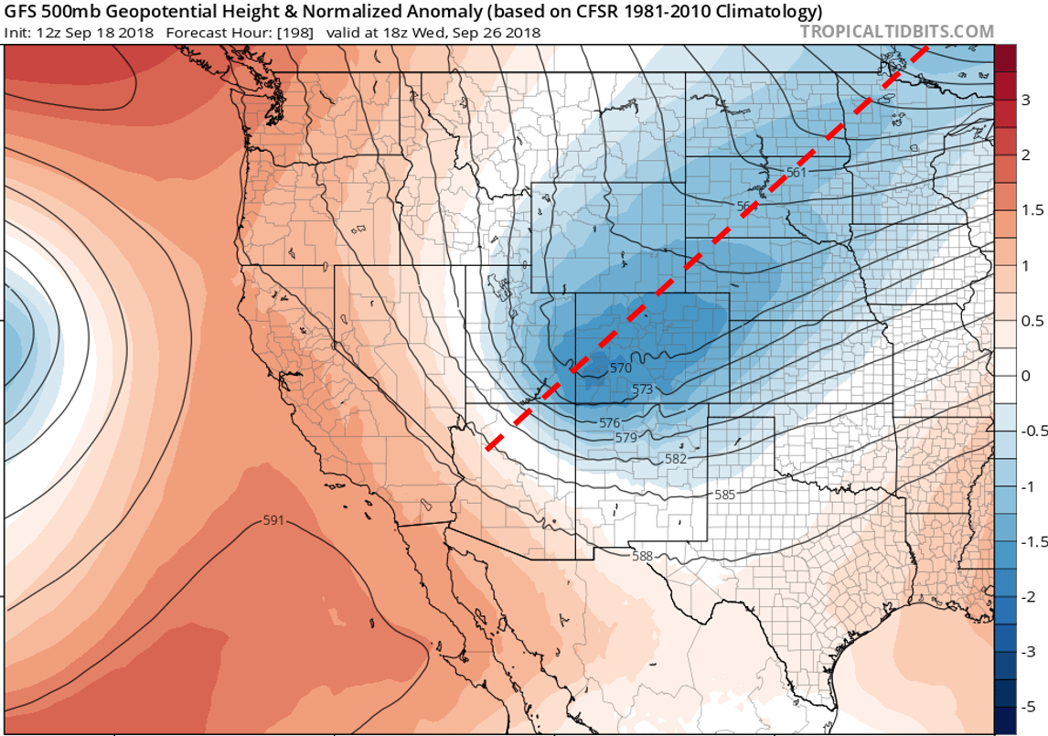
GFS height anomaly forecast for Sept 26 2018 showing a well-defined trough moving across Colorado.
We do want to stress the large uncertainty in the shape and magnitude of the incoming trough. The more the trough digs southward, the colder it will be and the better chance we have of seeing precipitation and maybe even snow. Shown below is a spaghetti plot forecast of 500 mb heights from the GFS ensembles for September 25th. Focus on the green lines. Each one represents a different ensemble member forecast. Notice that there is a huge variation in what the trough will look like come next week. The furthest north green line in Canada indicates no trough at all, while some members deepen the trough all the way into extreme southern California. Based on these ensembles, there is about a 75% chance of a sizable trough impacting Colorado around the middle of next week. This leaves a 25% chance of little to no impact for us.
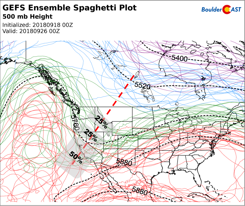
GEFS 500 mb height spaghetti plot forecast for Tuesday Sept 25. A trough is expected to develop over the West, the magnitude of which is uncertain at this time.
In general, though, there is good agreement for a major cool-down next week. The timing of the cold air varies between Tuesday and Thursday right now.
Does the GFS precipitation forecast below for next Wednesday get you excited?
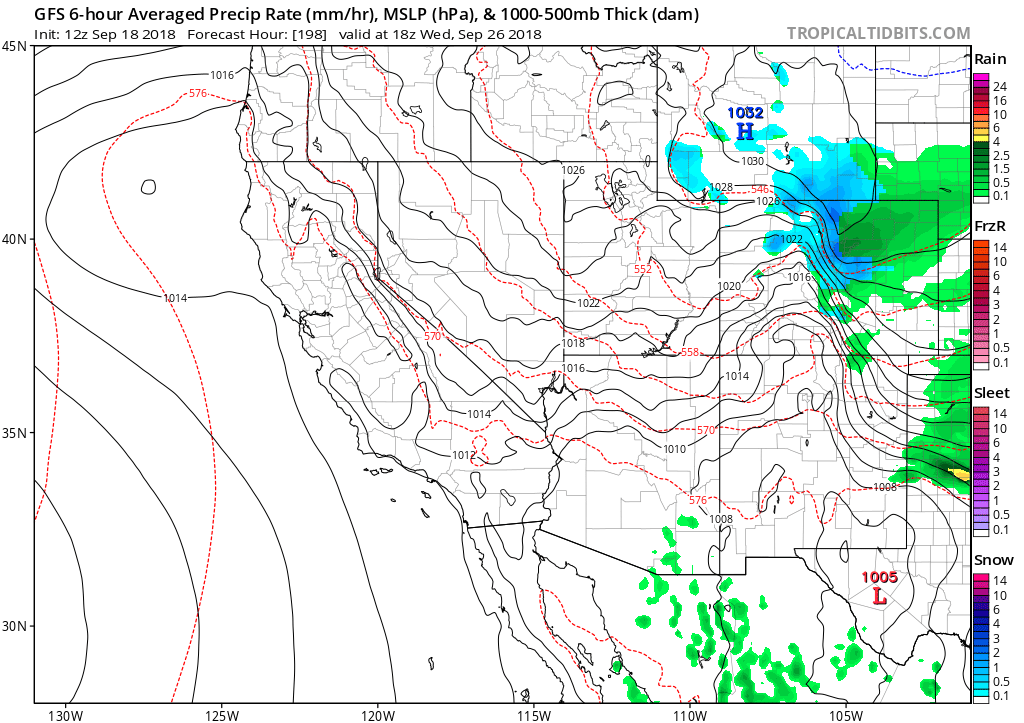
GFS precipitation and pressure forecast for Wednesday Sept 26. A shield of upslope rain/snow is indicated for the Front Range in this model run.
What about the GEFS snowfall forecast panels? Numerous members are showing accumulating snow in the Foothills, with even a couple producing the first snow of the year for the Plains.
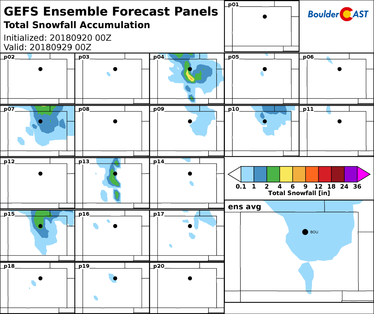
Right now, we aren’t buying that the trough will be deep enough to produce snow in Boulder or Denver. There is a very specific weather pattern needed to produce snow so early in the season on the Plains. This isn’t it. The Foothills, on the other hand, have a shot. We’ll definitely be following this pattern shift heading into next week for you. For now, expect things to cool off next week, but no snow just yet. Check our always up-to-date Snowfall Probability Charts for the latest odds of seeing snow both at high and low elevations over the next 15 days.
Enter out 2018 First Snow Contest!
Without further adieu, let’s move on to the contest! This is a community poll for the date you think the first MEASURABLE snowfall will occur in Boulder. Those who come closest to the actual date are the winners. For verification, we’ll go off the official Boulder climate station located at the NIST building in south Boulder (FYI, they follow UTC time for date cut-offs).
For prizes, we’re giving away free BoulderCAST Premium subscriptions and a T-shirt. Among many perks, Premium members get full-access to our daily forecast discussion every morning at 5:00 AM. This is especially useful in the winter, when our meteorologists brain-dump thoughts for days leading up to impactful snowstorms. In case you weren’t with us last three winters, we do quite well for the entire Denver Metro area’s snow forecasts.

The prizes for the contest are as follows:
- 1st place: 12-month Premium subscription + BoulderCAST T-shirt
- 2nd place: 6-month Premium subscription
- Anyone who guesses within 1 day OR 0.1″ correct: 2-month Premium subscription
- All other entries: Virtual “pat on the back”
In the event that multiple participants select the same date, the tie-breaker of snowfall amount will be used.

To get things started, here are the dates that some of BoulderCAST Team has placed their bets on:
- Ben: October 8th – 0.7″
- Andy: October 20th – 3.0″
- Keah: October 27th – 2.0″
Enter you NAME, EMAIL, and guesses for DATE and AMOUNT in the form below on or before Monday September 24, 2018. Please only one entry per person.
BOULDERCAST 2018 FIRST SNOW CONTEST ENTRY FORM
*THIS CONTEST IS NOW CLOSED TO ENTRIES*
*We respect your privacy. Your email will not be used for anything more than to contact you in case of meteorological victory.*
Prizes and recognition will be awarded in the days following our first dumping of snow. Let’s hope it’s a big one!
Please share this forecast and contest:
.


You must be logged in to post a comment.