

Hooray! Monsoon season has just begun and the beneficial rains are already on the way to Colorado! We take a look at the current monsoonal pattern, the cool and wet forecast for the next five days, and why we think the rainy pattern won’t last long.
At a Glance:
- The faucet has finally opened with monsoon season beginning in the southwestern United States, two weeks later than normal
- The pattern remains cool and wet across the Front Range into early next week (no 90’s!)
- Long-range model forecasts show a swift shift back to the very same pattern that made most of July so dry and brutally hot
Help support our team of Front Range weather bloggers by joining BoulderCAST Premium. We talk Boulder and Denver weather every single day. Sign up now to get access to our daily forecast discussions each morning, complete six-day skiing and hiking forecasts powered by machine learning, first-class access to all our Colorado-centric high-resolution weather graphics, bonus storm updates and much more! Or not, we just appreciate your readership!

N
orth American monsoon season usually begins around July 10th. However, depending on the large scale weather patterns over the North American continent, this timing can be quite variable from year-to-year by up to a few weeks either way. We let you know about a month ago that the monsoon would likely be arriving late this year, with the widespread drought across Colorado expected to get worse before it got any better. This is exactly what has transpired so far this summer.
However, the flood gates have opened! It’s with great pleasure that we can announce the official start of the 2020 monsoon season today, July 24th! This timing means that the monsoon has shown up about two weeks late this year. The daily average dew point in Tucson, AZ has indeed now eclipsed 54°F for three consecutive days, with moisture flowing into the southwestern United States having exceeded the monsoon threshold. This comes after the air in southeast Arizona had been drier than normal for much of the last eight weeks.

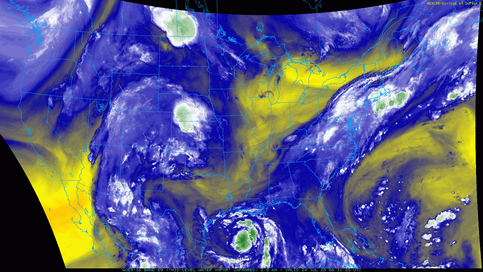
A look at GOES-East water vapor imagery from today shows the long and narrow plume of subtropical moisture streaming northward from Mexico into Arizona and even up into the Front Range.
We talked a little about this changing pattern in our weekly outlook this past Monday. Shown below is the GFS model forecast from five days ago for Friday evening. The plume of moisture in the five day old forecast (below) matches up well with the observations today (above). Not bad for such a long lead time.

You can thank the monsoon for those mid and high-level clouds fanning out across our area this morning, and the scattered to widespread thunderstorms that will develop across the Denver Metro area through the rest of your Friday.

Precipitable water, also known as total column water vapor, is forecast to increase to around 1.5″ in the Denver area this evening (see below). This would be the highest it has been thus far in 2020 for our area. Precipitable water values this high can support very heavy rainfall, with borderline tropical downpours. Any storms that form in this environment today (and the coming days) will have the means to put down a lot of rain very quickly.

Upper-level steering winds are rather moderate across Colorado, so the potential for flash flooding is low at the moment. The exception is in the area near Wray in far eastern Colorado where Flood Watches and Warnings are posted for the localized area that got pounded with 4 to 10″ of rain just last night (yes, 4 to 10 inches!).
Slow-moving thunderstorms trained for nearly 10 straight hours last night near the intersection of CO, KS, and NE. Rainfall totals ranged from 4 to 10" in a small area causing flash flooding. Neither Boulder nor Denver saw rain#COwx #KSwx #NEwx #FloodWarning #Flood #HeavyRain pic.twitter.com/u8TMWORPiZ
— BoulderCAST Weather (@BoulderCAST) July 24, 2020
We are, however, getting into peak flood season for the Front Range over the next week or two, so do keep that in mind.
The monsoon pattern will linger through the upcoming weekend into early parts of next week with favorable chances of thunderstorms each and every day, especially across the Mountains. Temperatures will also be noticeably cooler with the increased clouds across the state. Can you believe we don’t have a single 90-degree temperature in our five day forecast?

The news isn’t all rosy in today’s update; we have some bad news as well. This favorable weather pattern that has helped to pull the missing monsoon moisture northward isn’t going to last all the long, at least according to the longer-range ensemble models. Here is where we are today (shown below). There is high pressure across the center of the country with a trough along the West Coast. The narrow corridor of stronger southerly winds between these two large-scale features is funneling the moisture right up through Arizona and into Colorado. This has allowed moisture thresholds for the monsoon to be exceeded, even though the real pattern behind the moisture influx is questionable as a true monsoon wind shift.

However, by the middle to latter part of next week, high pressure is forecast to rebuild directly over the Desert Southwest and Four Corners areas (see below). This is the very same pattern that made much of June and July so persistently hot and dry in Colorado.
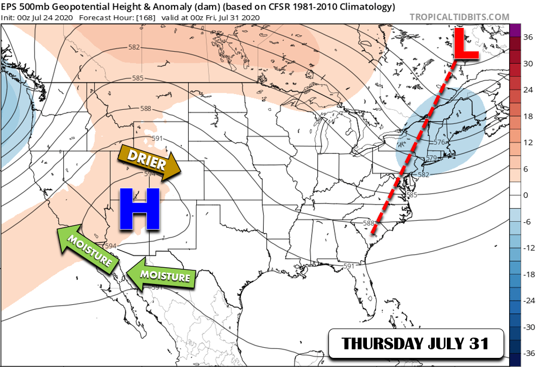
Unfortunately, there is exceptionally good model agreement for this ridge of high pressure to return to the Four Corners swiftly next week. The Euro (below left) and GFS (below right) ensembles are displaying incredible consistency right now on this facet of the extended forecast. Needless to say, this does color us a bit concerned considering the widespread drought across the state.

Nonetheless, we are in the warmest and most moisture-rich time of year right now. Even with the expected shift away from deep monsoonal flow next week, there will still likely be enough recirculated moisture available to produce daily thunderstorms, even under the strong high pressure center. Will it be enough to put a significant dent in the ongoing drought across the state? Probably not, but we’re happy to be wrong this time.

That’s all for now. We’ll catch back up with you on Monday with our usual weekly outlook. Have a good weekend!
Help support our team of Front Range weather bloggers by joining BoulderCAST Premium. We talk Boulder and Denver weather every single day. Sign up now to get access to our daily forecast discussions each morning, complete six-day skiing and hiking forecasts powered by machine learning, first-class access to all our Colorado-centric high-resolution weather graphics, bonus storm updates and much more! Or not, we just appreciate your readership!
.
Subscribe to receive email notifications for BoulderCAST updates:
We respect your privacy. You can unsubscribe at any time.
Share the good news about the monsoon:
.


You must be logged in to post a comment.