
Brace for the heat wave! A strong ridge of high pressure will dominate our weather pattern for the next seven to ten days. Temperatures through the week will push well into the 90’s each and every day with perhaps a few triple digit readings later this week as well.
This week’s highlights include:
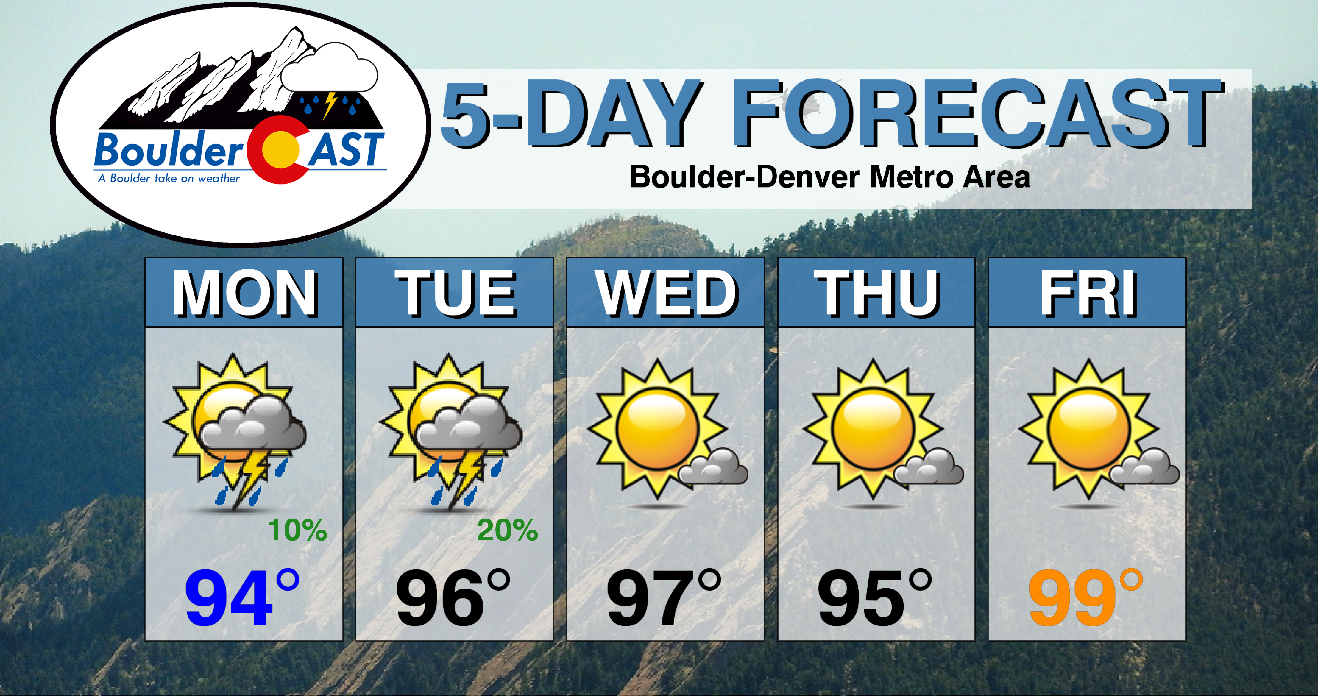
- Lingering moisture across the area will lead to slight chances for thunderstorms Monday and Tuesday, but very little rain
- A potent ridge of high pressure intensifies over Arizona and New Mexico as the week progresses, dominating our weather pattern
- Very warm and predominantly dry conditions will be with us for the next seven to ten days as a result of the ridge
- Scorching temperatures are expected every day with highs from the middle 90’s to lower 100’s…a true heatwave!
DISCLAIMER: This weekly outlook forecast is created Monday morning and covers the entire upcoming week. Accuracy will decrease as the week progresses as this post is NOT updated. To receive daily updated forecasts from our team, subscribe to BoulderCAST Premium.

A hot early week with slight rain chances
We hope you had a safe and enjoyable holiday weekend. From the sounds of the constant fireworks lingering into the wee morning hours every night, we’d say you did!
We begin the week sitting under continued high pressure with just a slight amount of residual moisture remaining across the area. If you recall, this moisture was related to a northward surge from Tropical Depression 4E late last week (not the monsoon). High pressure currently resides across much of the Desert Southwest, extending offshore of southern California as well.

As drier air filters in over the coming days, rain chances will linger but with very low probabilities across the Front Range. What little moisture remains is largely elevated with drying noted at the surface. This will translate into only isolated weak storms across the Denver Metro area. Gusty winds will be the primary concern, with only brief light rainfall expected from any showers and storms that do develop in the less than favorable environment. This ever-so-slight chance of rain will be in our forecast both Monday and Tuesday.
NOAA’s Storm Prediction Center curiously includes portions of the northern Front Range at “Marginal” risk for severe thunderstorms Tuesday afternoon (see below). A shortwave system will be progressing across Montana and Wyoming, riding along the northern periphery of the Four Corners ridge. Bulk shear will certainly increase as this shortwave passes, at least lending the possibility of strong to severe weather, but instability and moisture are both sub-par in our opinion. We’ll keep an eye on this, but at the moment, we are not optimistic for any severe weather on Tuesday. Most of us in fact will be dry.

Beneath the ridge, temperatures will continue to sizzle across the area with highs in the middle 90’s early in the week. Daily high temperatures will largely occur during the early to mid-afternoon timeframe just as clouds begin to fill the sky.

The REAL heat wave arrives later in the week
We warned you of this scorching pattern taking shape at least five days ago, and it is certainly still on-track. If you haven’t read our broader post covering the anticipated late arrival of the monsoon and ongoing regional drought, now is a good time to catch up!
An even more potent ridge of high pressure is expected to fortify its presence later this week across the Four Corners region leading to blistering heat over much of the Desert Southwest, including all of Colorado as well. Just look below at how the high pressure center intensifies and grows to consume a huge area later this week. The 500 mb height anomalies shown below are impressive in both magnitude and scale, even by July standards.

Our temperatures under this pattern will eventually soar into the upper 90’s to low 100’s. There are two potential wrinkles in the forecast that could keep us slightly cooler, however.
There will likely be a few weak, backdoor cold fronts sliding through Wyoming Wednesday and possibly again on Friday. These fronts will be associated with disturbances along the Canadian border. The timing is unclear, and it’s also uncertain to what degree these fronts will impact northeast Colorado. Outflow from storm clusters to our north could help push the cooler air southward into the Front Range as well. Should this materialize, we could see highs several degrees colder in the low to middle 90’s…definitely not enough to break the heat wave.

Moisture will also begin to creep back up over the weekend with storm chances likely returning to the area. Another tropical disturbance in the Eastern Pacific, currently described as “Invest 97E”, is expected to develop into a tropical storm and move northwestward.

Similar to what unfolded last week, this will help pull subtropical moisture northward into the Desert Southwest and eventually Colorado, too. The center of the potent ridge discussed earlier being located over New Mexico and west Texas should also help this moisture funnel northward into Arizona.

It will be a hot and dry latter part of the week. Thursday may be slightly cooler with that front brushing the area (low to middle 90’s). By Friday, the oven dial will get turned back up with highs pushing into the upper 90’s to low 100’s.
The heat wave will continue into the weekend with the core of the warmest air sitting directly over Colorado.

Saturday, however, is about the time we would expect the subtropical moisture to arrive in our area. Even though the warmest air will be present, we may see storm chances return to the forecast with isolated to scattered coverage over the Front Range helping to take the edge off the heat, but just barely. The increased cloud cover and rain could help prevent widespread record high temperatures, but we will still be in that ballpark. Unfortunately, we are predicting that highs near 100 degrees will linger through the weekend and into early next week.

GFS ensemble forecast high temperatures for Monday July 13th showing readings in the low 100’s in the Metro area.
We know exactly what you’re wondering….When is it going to cool-down? Unfortunately, at this point, we’re not expecting any real reprieve from the heat to arrive until the middle of next week at the earliest. Temperatures will remain well above seasonal normals with mainly dry weather persisting until then. The cool-down next week is about 10 days out, so the forecast of course is highly uncertain. It looks like that even if it does come, the pattern won’t change much. Any reprieve would likely be short-lived with the heat rebuilding very quickly after one or two slightly cooler days.

8-14 temperature outlook probabilities for the USA. Colorado is expected to be above normal during this time of July 13 to 19th | Source: NOAA Climate Prediction Center
The heat wave at-hand is no joke. It will be intense and long-lasting, certainly perpetuating the ongoing drought across southern Colorado.
Woohoo! 🎉 Colorado is ranked #3 in the United States…..for most drought-stricken by percent area… 😥#COWx #Drought #Colorado #RainDance #Boulderwx pic.twitter.com/X2p7uRVa1g
— BoulderCAST Weather (@BoulderCAST) July 6, 2020
Hopefully your air conditioner is tested and in working order. It will get a lot of use this week and weekend! Stay cool!
Reminder: Today is the final day of our 4th of July sale. Save 25% on BoulderCAST Premium with promo code FREEDOM through 11:59PM MT. Join now.

Forecast Specifics:
Monday: Morning sun with increasing clouds during the afternoon. Isolated showers and thunderstorms are possible in the 2PM to 8PM timeframe, with light rain and gusty winds. Highs in the middle 90’s on the Plains and near 80 degrees in the Foothills.
Tuesday: Sun early, then increasing clouds through the afternoon with a very slight chance of a passing thunderstorm. Highs in the middle 90’s across the Plains and lower 80’s in the Foothills.
Wednesday: Mostly sunny and hot with high temperatures in the mid to upper 90’s on the Plains with lower 80’s in the Foothills.
Thursday: Mostly sunny and hot with highs in the middle 90’s on the Plains and lower 80’s in the Foothills.
Friday: Mostly sunny and even hotter with highs in the upper 90’s to lower 100’s across the Plains and middle 80’s in the Foothills.
Weekend: The heat wave continues with highs right around the 100-degree mark both Saturday and Sunday. Model consensus is not great, but there is some indication that there could be a few isolated thunderstorms around over the weekend as well. Overall though it will be mainly dry with many Front Range cities will be flirting with daily record highs.
High Country: Limited moisture will lead to isolated storms across mainly just the Front Range Mountains Monday and Tuesday. Most of the state will be dry. Wednesday through Friday will be completely storm-free and warm with high pressure overhead. Expect temperatures well above normal with snowpack continuing to dwindle. Check SummitCAST for daily updated forecasts for more than 120 mountain hiking destinations across Colorado.

We discuss Boulder and Denver weather every single day on BoulderCAST Premium. Sign up today to get access to our daily forecast discussions every morning, complete six-day skiing and hiking forecasts powered by machine learning, access to all our Front Range specific weather models, additional storm updates and much more!
.
Spread the word, share the BoulderCAST forecast!


You must be logged in to post a comment.