Accumulating snow and frigid temperatures are on the way for most of Colorado! Read on as we discuss the arrival of the first Arctic cold front of the season, one which has good timing to coincide with the winter solstice on Thursday.
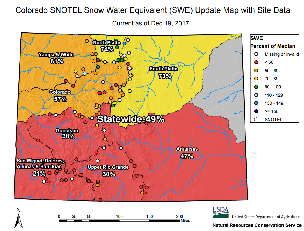
Snowpack is far from healthy right now
The latest snow water equivalent (SWE) reports put snowpack statewide at just 49% of normal for mid-December, with the northern mountains fairing marginally better than the southern half of the state.
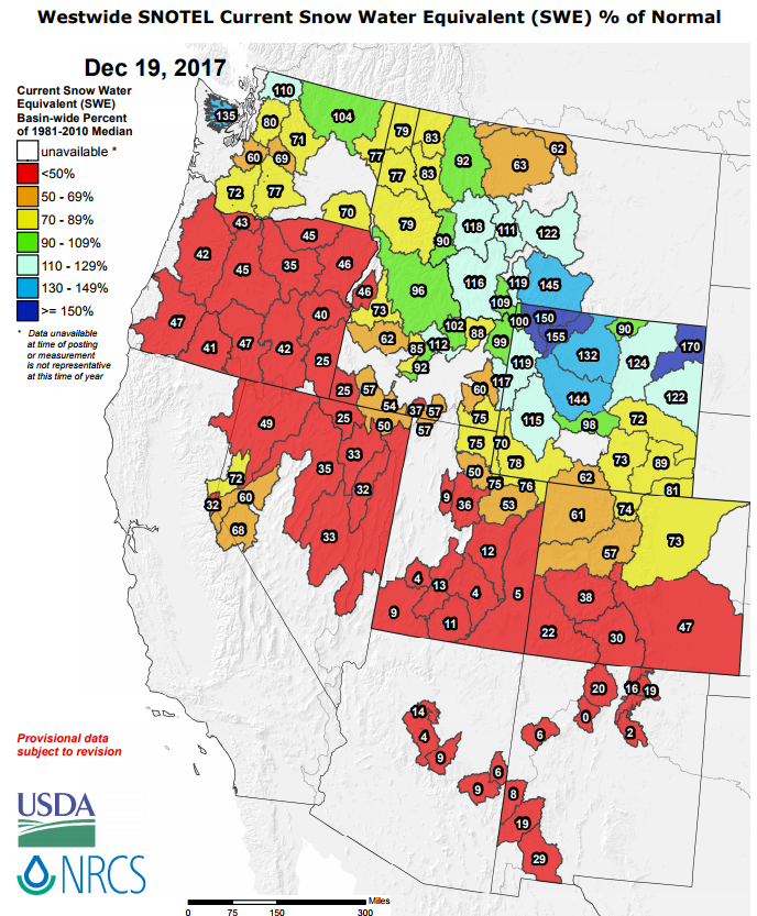
Looking more broadly at the entire Western United States, snowfall this winter has been dismal for most locations. The astounding exceptions are parts of Wyoming and Montana!
The lack of snowfall of late is the result of a persistent ridging pattern across the Pacific Northwest and western Canada. We have been discussing this pattern like a broken record for more than a month now. We thank you for bearing with us through this period of boring weather…
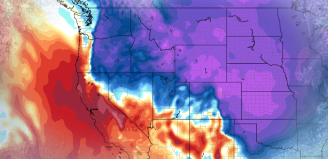
This ridge has disrupted the Pacific storm track enough to push most of the action northward into Canada and even Alaska at times. The map below shows observations of the 500 mb geopotential height anomaly over the last 30 days for the Northern Hemisphere. This isn’t just a snapshot in time; this is the average pattern during the entire last month. Our resilient ridge of high pressure is clearly evident.

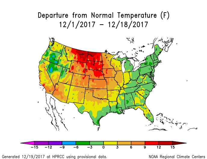
This pattern has prevented juicy Pacific moisture from reaching Colorado….the storm systems that generally have the biggest contribution to our snowpack. While we have had a few quick-moving weather events with continental origins, they have produced minimal snowfall for the state overall. Temperatures have also been running WELL above normal under the ridgy pattern.
A pattern shift which began late last week is set to bring a rude awakening to the region tonight with the arrival of our first Arctic airmass of the season!
A thin blanket of snow
Today’s high temperature will be deceivingly warm, somewhere in the ballpark of 60 to 65 degrees across the Metro area. However, current model trends slam a frigid cold front into northeast Colorado before sunrise Thursday. The airmass behind this front will be our coldest air since Groundhog Day 2017!

NAM 800 mb temperature and wind forecast map for Thursday morning. The cold front will arrive between midnight and 3AM tonight.
Blustery northeast winds will accompany the frontal passage with snowfall commencing shortly thereafter. The GFS model paints a very promising picture for upslope into the Metro area late tonight into the morning on Thursday. At the 700 mb level, due easterly upslope of 15 mph is forecast over Boulder early Thursday, the perfect direction to squeeze out moisture into snowfall for the city and nearby Foothills.
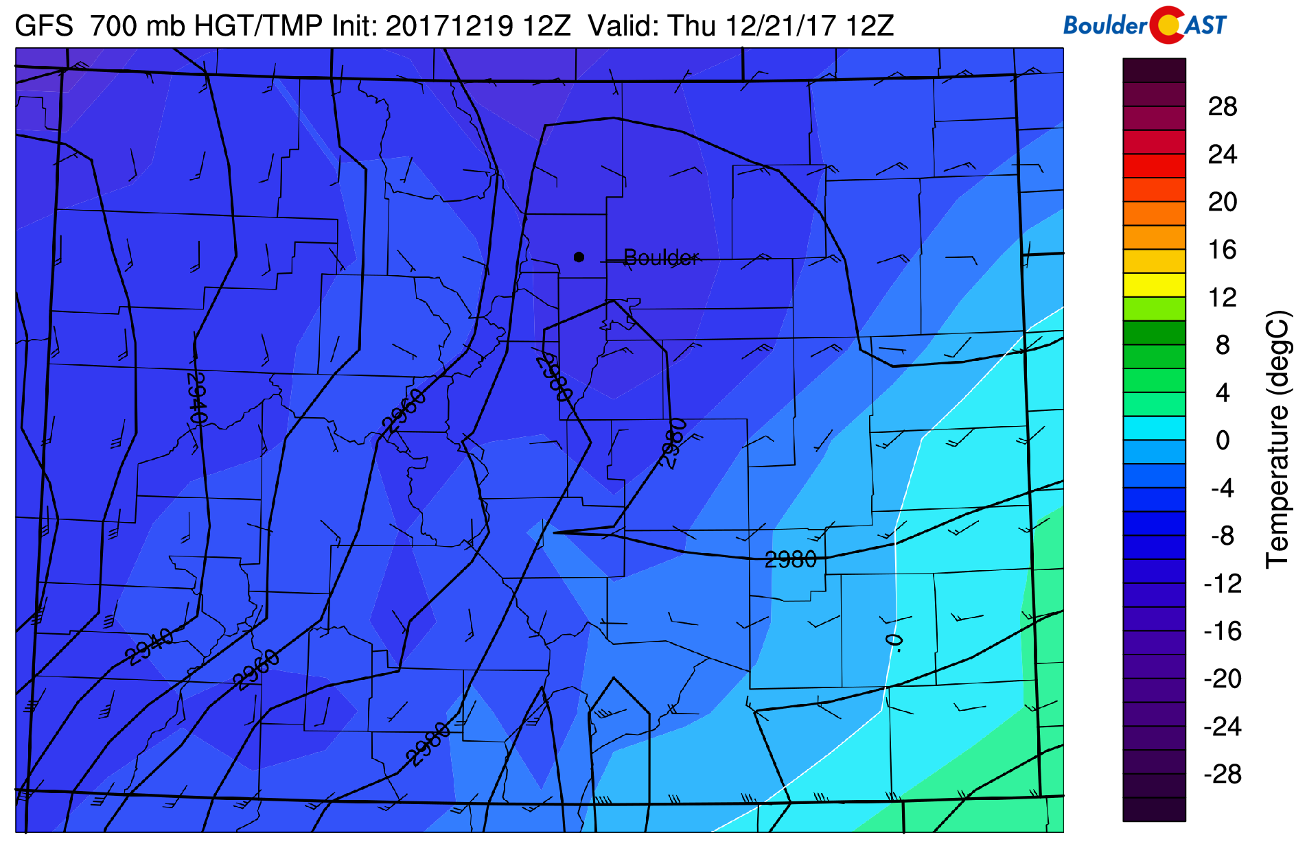
GFS 700 mb temperature and wind field for Thursday morning showing very cold temperatures and upslope across the region.
We will also see some mid-level ascent with this storm system for much of Thursday, mainly across western Colorado, however. The 500 mb vorticity animation below shows a closed-low forming near the Four Corners region Thursday afternoon. This positioning will put much of the state in a favorable region for lift. In addition to the Front Range, almost all of the mountains and valleys will be donning a blanket of white come Thursday evening.
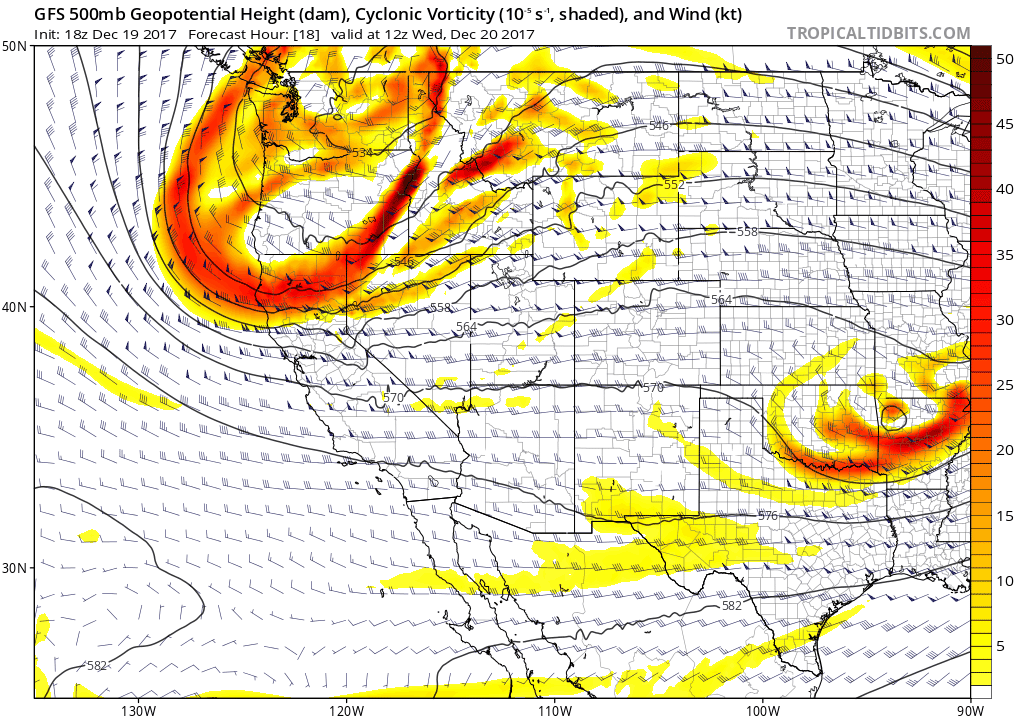
GFS 500 mb vorticity animation for Wednesday evening into Friday morning.
One disappointment is that the closed-low is being forecast consistently by the GFS and Euro models to transition quickly into an elongated open-wave by Thursday evening as it moves into northwestern New Mexico. Had this system slowed and stayed a closed-low longer, we would be seeing more white stuff!
Due to the cold air, snow ratios for this event will be the highest we have seen since last January….likely around 15 to 1 in Boulder/Denver and possibly closer to 20 to 1 in the Foothills. To the dismay of snowman enthusiasts, tonight’s snow will be the fluffy and dry variety. This type of snow will help boost snow totals slightly across the region.
TIMING:
Snow will begin abruptly following the passage of the cold front, likely between 3:00 AM and 6:00 AM early Thursday morning. Light snow will continue through the morning, lingering into the afternoon or possibly evening in and near the Foothills. Some bands of moderate snow will be possible as well, especially during the morning hours.
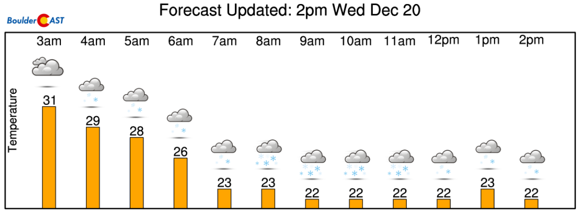
Hour-by-hour forecast for Thursday morning. Let it snow! From NowCAST
AMOUNTS:
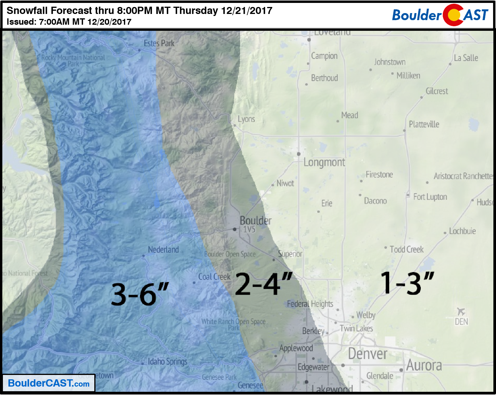
There is fairly good agreement in the models for 0.2 to 0.4″ of liquid across the area, with the highest amounts in and near the Foothills. All atmospheric ingredients suggest these amounts are on-track. Given the fluffy snow ratios, our forecast is for 2-4″ in Boulder, 2-5″ in the Foothills, and 1-3″ for the rest of the Denver Metro area.
Our snowfall forecast map is below:
This storm will benefit the southwestern mountains more-so than the I-70 corridor. Nonetheless, all the resorts should pick up at least some snow by Thursday evening.
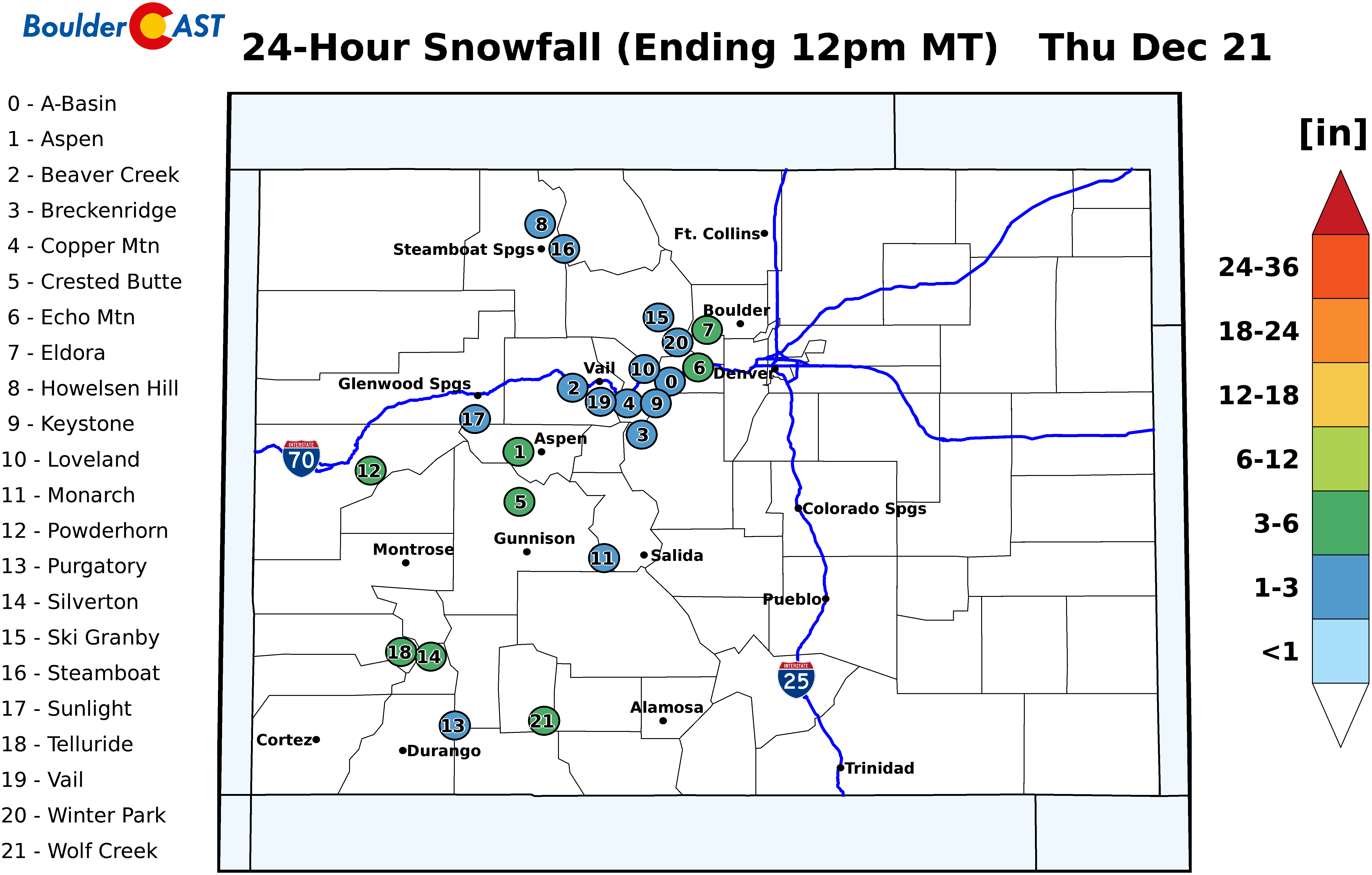
Snowfall forecast for the ski resorts on Thursday. Find more details on our PowderCAST page
TRAVEL IMPACTS:
Temperatures will quickly fall into the 20’s behind the front, then hover around 20 degrees through the day on Thursday. With temperatures this cold and the sun literally the lowest it can be in the sky (it’s the solstice!), snow will have no trouble accumulating on the roadways. Combined with the gusty winds and potential drifting snow, Thursday morning’s commute will be slick, and possibly the evening commute as well.
Enjoy the true start to winter tomorrow! You’ll likely be hearing from us again soon . More cold temperatures and another chance of snow is brewing for Saturday.
Stay tuned…
Subscribe to receive email notifications for BoulderCAST updates:
We respect your privacy. You can unsubscribe at any time.
.
Share this forecast:
.


You must be logged in to post a comment.