
Read on as we detail the weather for the week ahead, including travel impacts for the Thanksgiving holiday.

Wave cloud sunset from North Boulder | November 19, 2017
Dry and warm November continues
The maps below look a lot like those shown in our La Niña winter outlook post. The northern Rockies have had a snowy November, but this hasn’t quite propagated into Colorado. Through the first two-thirds of the month, only 0.48″ of precipitation has been recorded in Boulder with temperatures averaging out to be about one degree above normal. It has been a tame month overall with more wind than snow thus far…
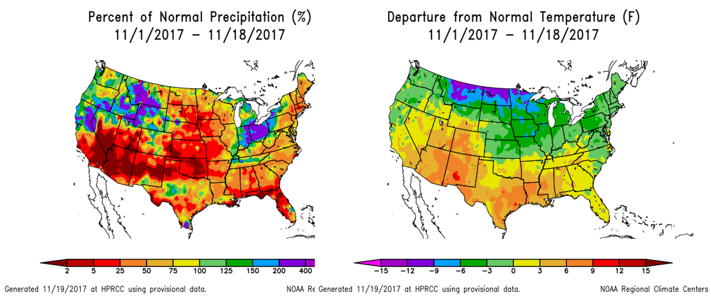
Percent of normal precipitation in November (left) and departure from normal temperature in November (right).
Despite limited storm activity, our snowpack is right at normal for this time of year (South Platte River Basin).
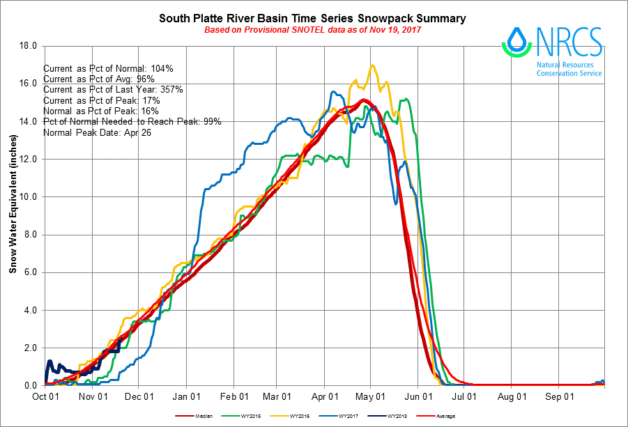
Snow-water equivalent for the South Platte River Basin through November 19, 2017 (dark blue line).
The week ahead will offer more of the same as ridging will dominate our pattern through the holiday and the weekend. After a dry and breezy day Monday with highs in the 60’s, our only chance of precipitation for the week comes late Monday night and Tuesday morning as a weak disturbance embedded in northwest flow glances northern Colorado.
The 500 mb map below for Monday evening shows the elongated trough of concern stretching eastward from British Columbia into Montana.
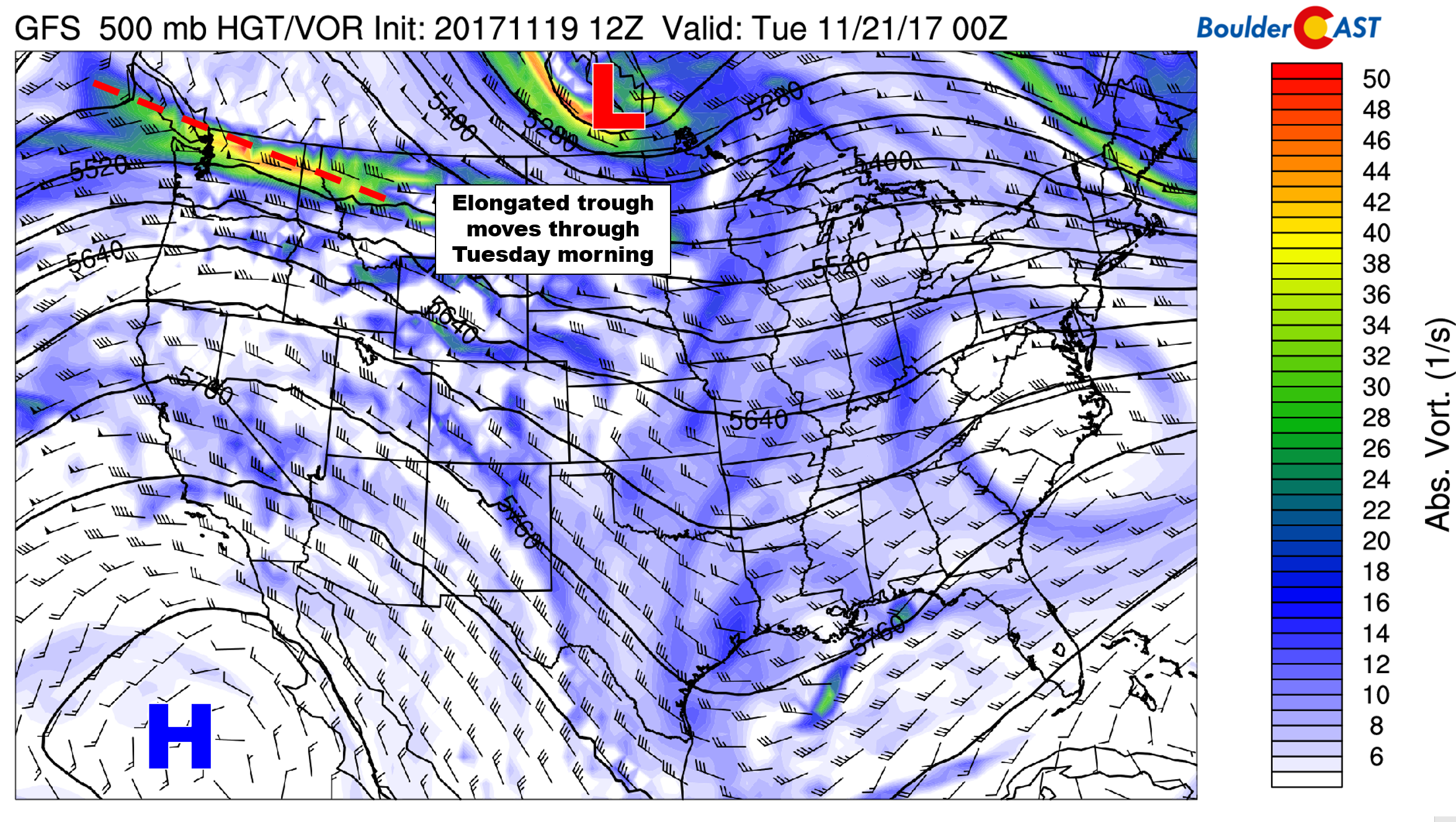
GFS 500 mb vorticity map for Monday evening
Its biggest impact will be light snow in the Mountains north of Interstate 70 tonight and early Tuesday. A dusting up to 3″ will be possible for areas above 10,000 feet west of the Divide.
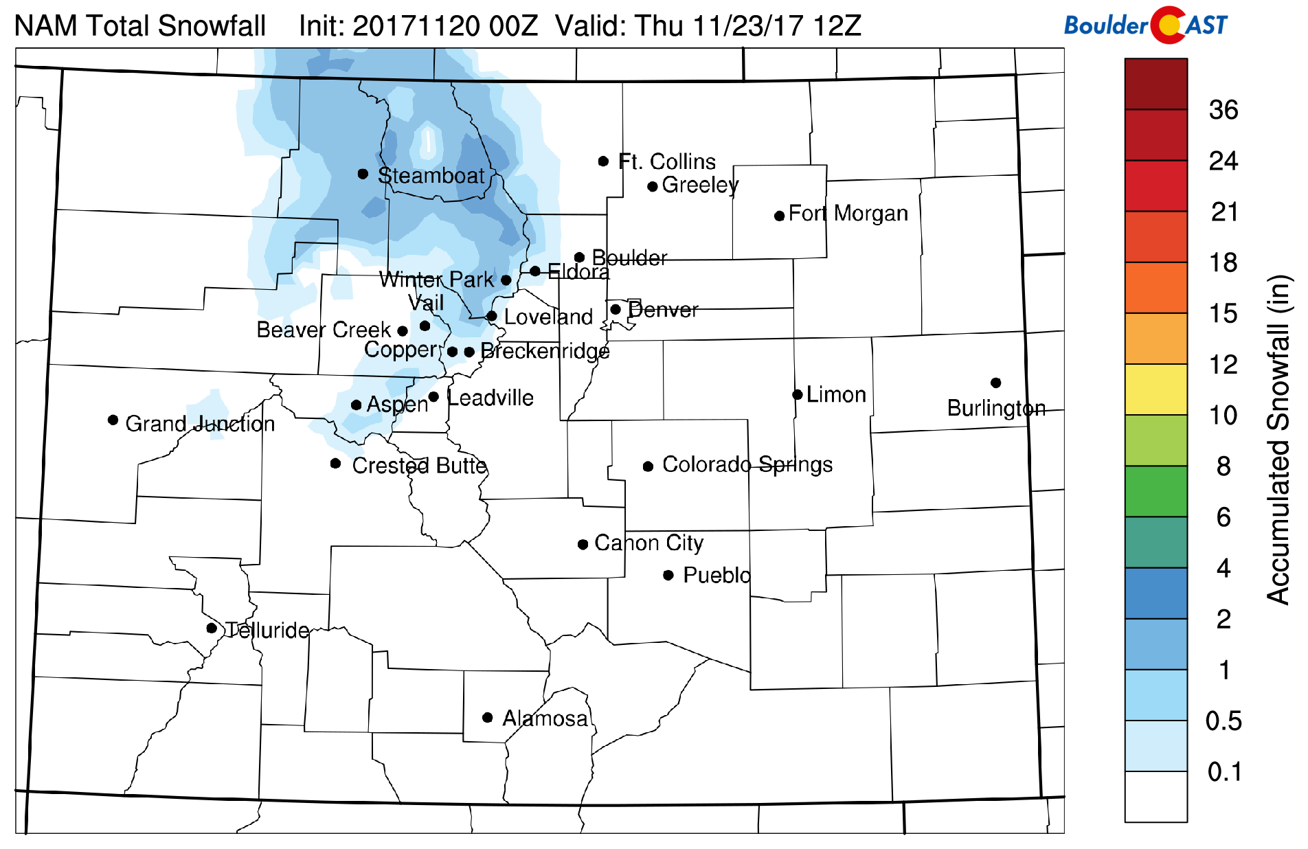
NAM-derived snowfall forecast for tonight’s event. Only light snow in the Mountains is expected.
Across the lower elevations, a weak cold front passes through the Denver Metro area after midnight tonight. Some of the higher resolution models are showing light showers before 10AM Tuesday, but we’re really not seeing good agreement. Expect just a 10% chance of showers/drizzle Tuesday morning, with mostly cloudy and dry weather the rest of the day. Tuesday will be the coldest day of the week, but not cold by any means for late November. Highs will remain several degrees above our seasonal norm (which is 52 degrees).
Record heat for Turkey Day?
A potent ridge builds in across the western United States Wednesday and is expected to persist into the weekend. The center of the ridge will remain parked across Baja California (shown below). During this time, dry northwest to west-northwest flow will keep things quiet across Colorado.
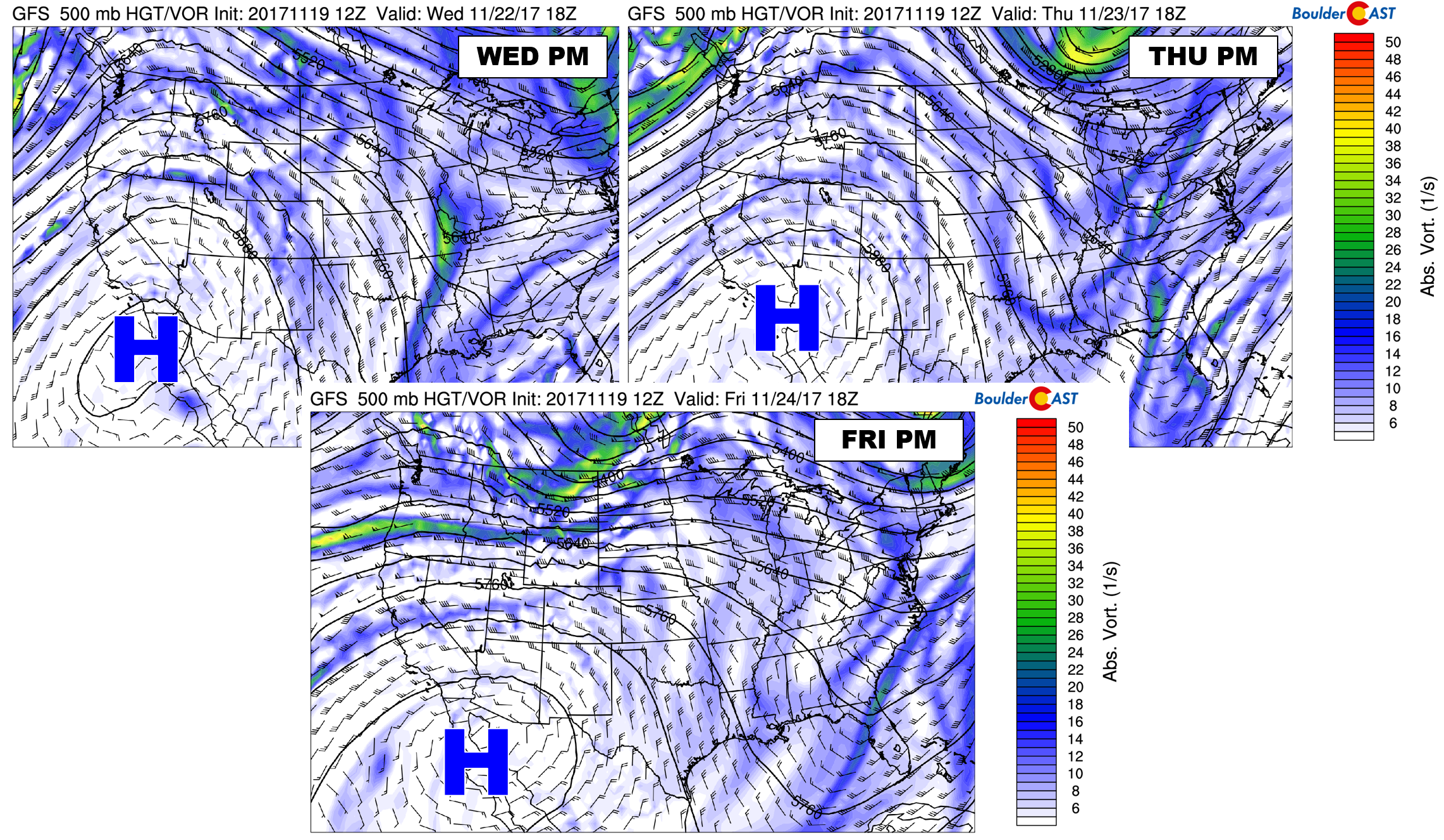
500 mb vorticity maps from the GFS for Wed-Fri. A ridge will dominate our weather.
Models are showing temperatures warming significantly for the ladder part of the week with this ridge in place. Middle 60’s to lower 70’s are expected Wednesday through Friday. The GFS model even shows the potential for record heat Thursday and Friday with temperatures in the middle 70’s. We’ll have to wait to see how this plays out…..record-breaking temperatures are not typically observed across the Front Range with northwest flow in place (though Friday’s wind field is slightly more west than northwest).
Overall, no weather impacts to your holiday travel plans, even those that include traversing into the Mountains. Have a safe and joyous Thanksgiving!
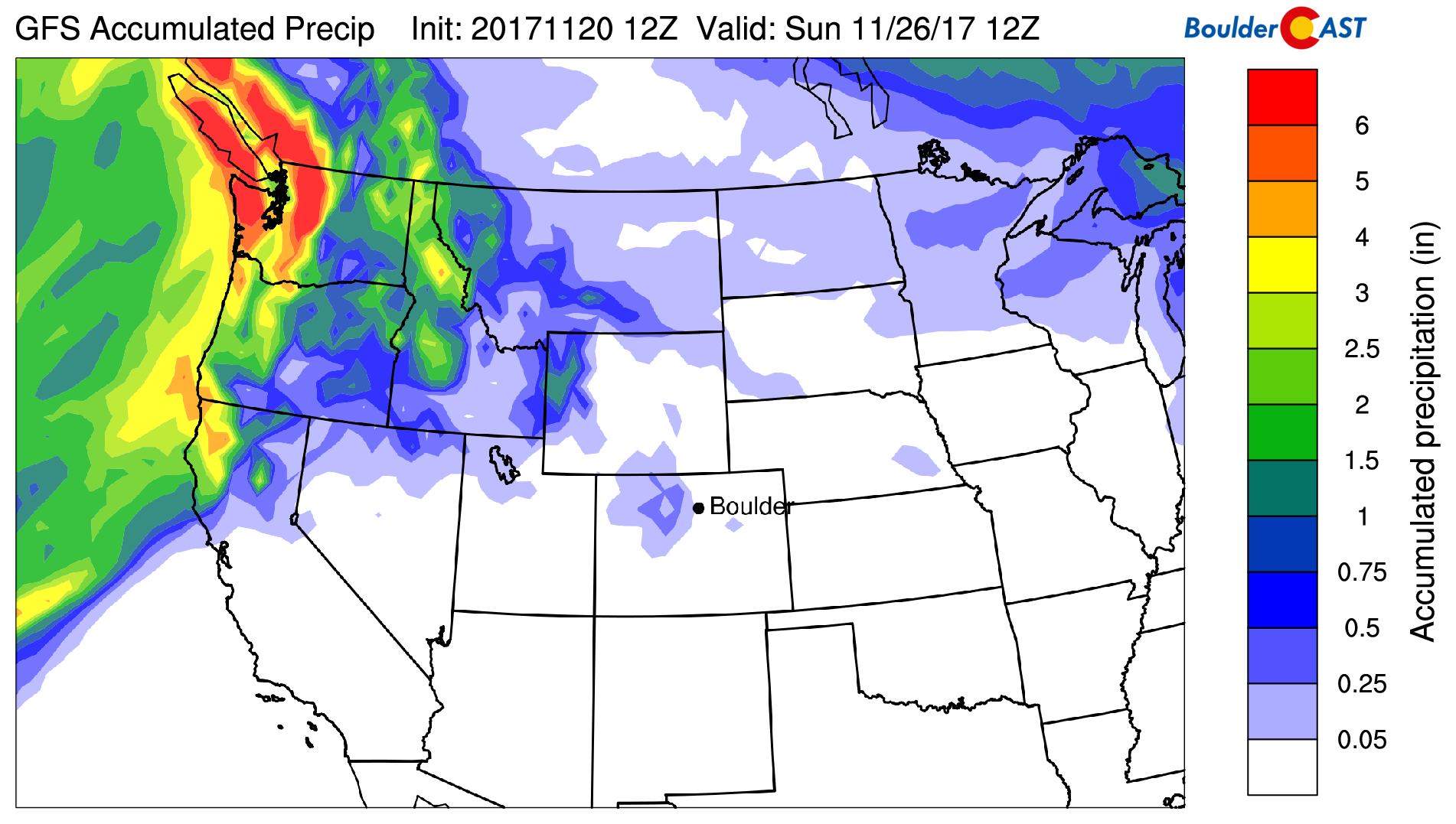
GFS total accumulated precipitation forecast through Saturday morning. Very little if any precipitation is expected in eastern Colorado.
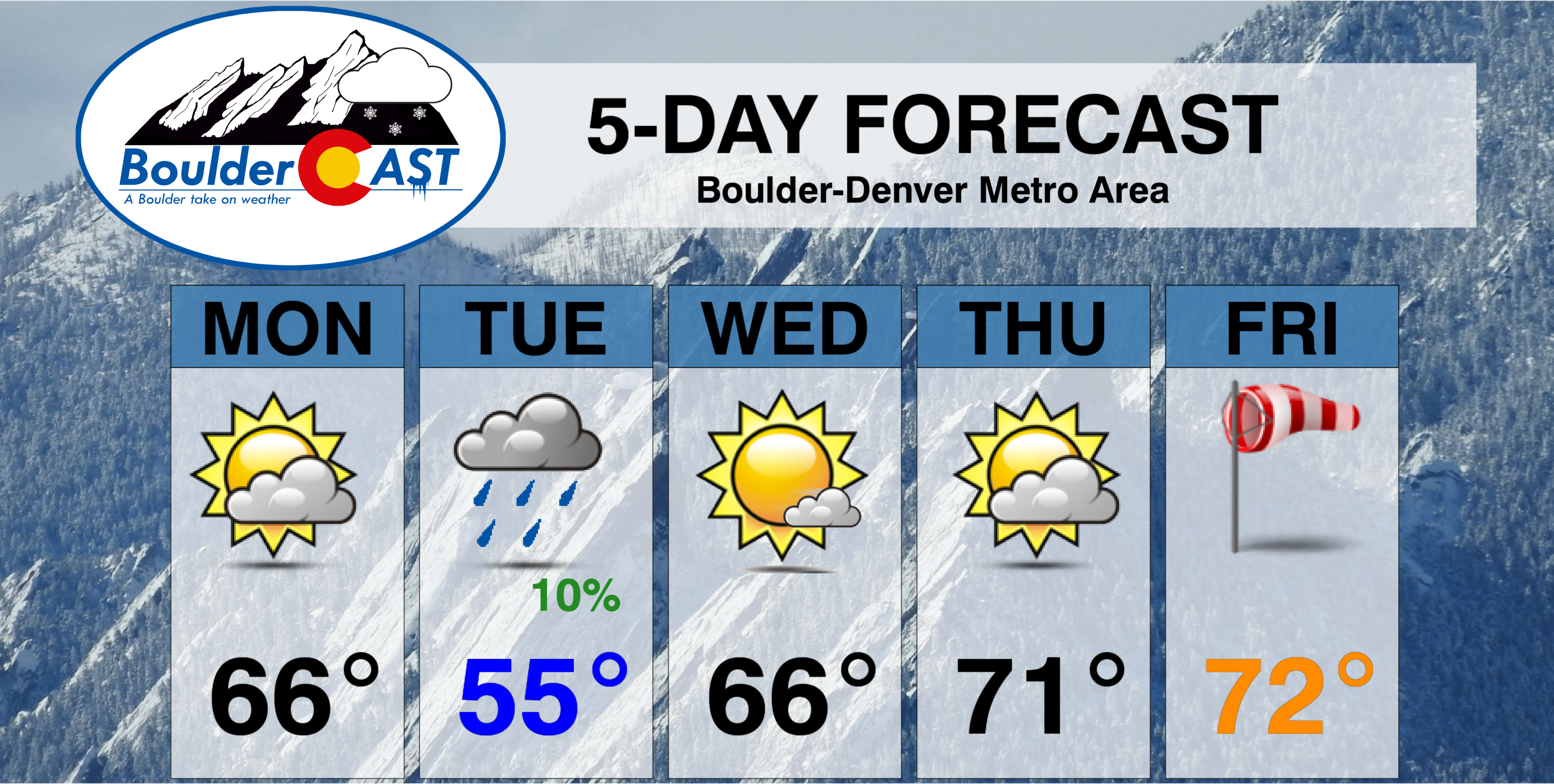
Forecast Specifics:
Monday: Partly to mostly cloud and warm, with gusty winds in the Foothills to 45 mph, with just breezy conditions across the Plains. Fire danger will be elevated. Temperatures in the middle 60’s across the Plains and middle 50’s in the Foothills.
Tuesday: Mostly cloudy with a slight chance of rain showers in the early morning. Highs cooler in the upper 50’s for the Plains, with upper 40’s in the Foothills.
Wednesday: A mild day with morning patchy clouds and afternoon sun. Temperatures in the mid 60’s on the Plains and mid 50’s in the Foothills.
Thanksgiving: Partly cloudy, warm, and calm. Highs near 70 on the Plains with upper 50’s in the Foothills.
Friday: A mix of clouds and sun with near record warmth. Expect highs in the low 70’s across the Plains, with low 60’s in the Foothills.
Weekend: Tranquil weather is expected to persist into the weekend. There is some indication of another weak system moving through Friday night. This could cool things down into the weekend, but probably not enough for temperatures to drop below normal.
High Country: Windy conditions will prevail across the Front Range mountains Monday and Monday night, with light snow possible above 10,000 feet west of the Divide early Tuesday. 1-3″ of accumulation is expected. Quiet conditions will take over Wednesday and persist into the weekend with temperatures above normal. Find the latest forecast for all your favorite Colorado ski resorts on our PowderCAST page.
DISCLAIMER: This weekly outlook forecast is was created Monday morning and covers the entire upcoming work-week. Accuracy will decrease as the week progresses as this post is NOT updated. To receive daily updated forecasts, subscribe to BoulderCAST Premium.

Share our forecast:
Just for fun:
Read our 2016 Thanksgiving outlook:
Read our 2015 Thanksgiving snowy forecast:


You must be logged in to post a comment.