Things are about to turn white across the region as a quick-hitting storm brings freezing temperatures and snow to the Front Range. Read on for details.
Fall from Broomfield….taken October 5 2017. The view will be similar through the weekend. Click for full resolution.
The SUMMER portion of the forecast:
We’ll start of by saying that you should enjoy the upcoming weekend! Warm westerly downslope flow will push temperatures across the lower elevations to near 80 degrees on Saturday and just a few degrees cooler for Sunday. Expect full sunshine with no chance of precipitation either day.
The 500 mb map below from the GFS valid Sunday morning shows the westerly winds across Colorado, as well as something looming to the northwest….
GFS 500 mb vorticity forecast for Sunday morning. Downslope is evident across Colorado
The WINTER portion of the forecast:
Our first snow last year did not occur until November 17th, the latest appearance of snow in Boulder and Denver on record. A weather feature headed our way is set to bring this year’s first snow six weeks earlier! We’ve been discussing this storm with our Premium subscribers for several days now as weather models have been remarkably consistent with the storm’s track and existence since Tuesday.
A trough is set to deepen into Colorado and Utah late Sunday into Monday. This can be seen in the 500 mb vorticity map below.
GFS 500 mb vorticity map for Monday morning
This trough will bring a strong cold front through northeast Colorado Sunday night. After temperatures near 70 degrees Sunday afternoon, we’ll fall into the mid 30’s by midnight. Summer to winter in the blink of an eye!
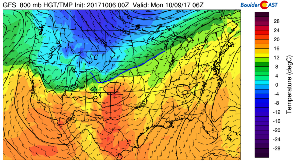
GFS 800 mb temperature map for Sunday night at midnight. The position of the cold front is highlighted in blue. Notice the strong northerly winds over northeast Colorado
There will be plenty of cold air associated with this system. Snow levels are forecast to drop below 5,000 feet by Monday morning….cold enough for snow across all of the Denver Metro area. The magnitude of the cold air is actually a little surprising for early October. It’s not record-breaking cold by any means, but usually it’s a slightly tougher decision to rule out rain this time of year.
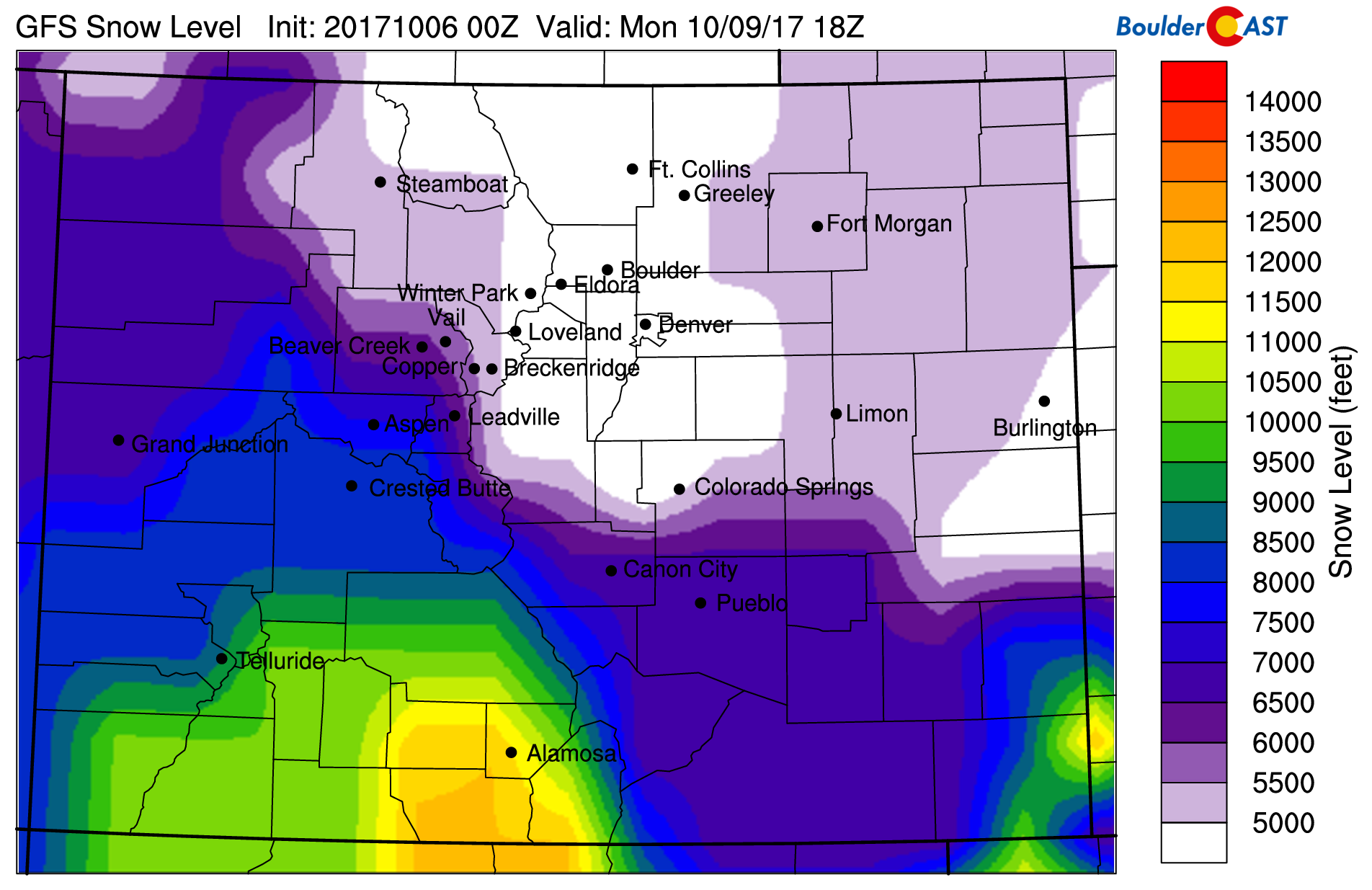
GFS model derived snow level forecast for Monday morning. Plenty of cold air to produce snow for everyone!
The key to this forecast is that this is a relatively quick-moving storm. The window of best upper-level forcing (right entrance of a jet streak & vorticity advection) and lower-level forcing (upslope) is tight, only about 12 to 18 hours stretching from around midnight Sunday night through late Monday afternoon. This speed will be the limiting factor on snow totals for this event.
Liquid precipitation amounts expected are in the 0.3 to 0.5″ range for the lower elevations, with perhaps 50% more than this in the Foothills….so this will be a decent snow event. A small portion of this may fall as rain before the change over to snow rapidly happens Sunday night. Temperatures will fall into the teens in the Foothills, and possibly into the upper 20’s across the Plains with snow falling. Winds will be a concern as well, gusting up to 35 mph north and east of Denver. Expect at least some blowing and drifting snow, too.
PRELIMINARY AMOUNTS
Here is what we are thinking for snow totals right now:
- Boulder and western Denver Metro: 3-8″
- Rest of the Denver Metro: 2-5″
- Foothills: 6-12″
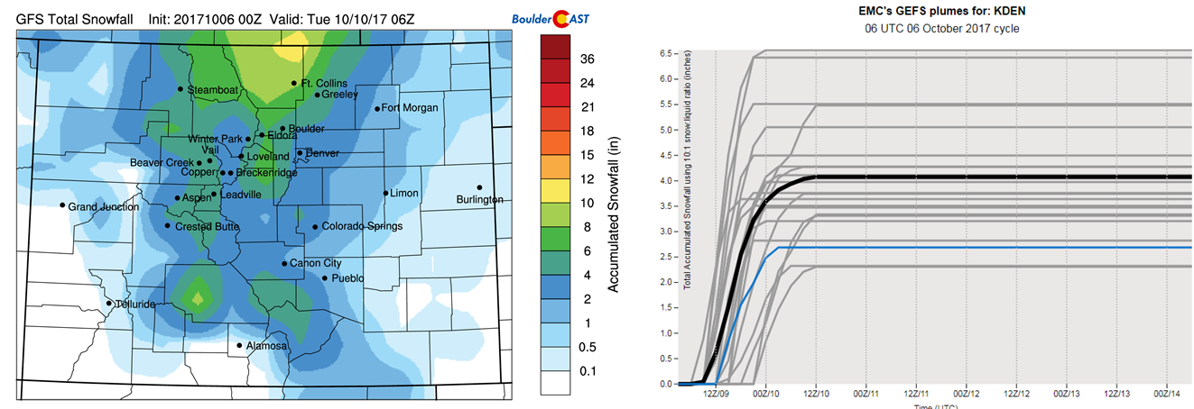
GFS model snowfall amounts (left). Its ensemble has fairly tight agreement for 2-5″ of snow at DIA (right).
Warm ground temperatures from Sunday afternoon will limit, if not prevent, snow accumulation on roadways across the lower elevations. Expect generally okay driving for Monday’s morning commute, but with slushy sections here and there. The Foothills will be much colder. Thus, expect snow-packed roads developing late Sunday night.
Here are a few things we’re watching over the weekend:
- Jet dynamics will be in play for the first half of the storm as northeast Colorado will be in the right entrance region of a jet streak. This will likely produce at least a few bands of heavy snow before sunrise Monday morning. We don’t expect these to linger in one spot for too long as the storm is fairly fast moving. We’ll need to see how the models handle these as we get closer.
- There is a slight discrepancy in the models in regards to timing at this moment, with the ECMWF bringing the system through about six to nine hours sooner than the GFS model. We have blended the solutions in our forecast for now, but know that timing could change slightly by the end of the weekend. The Euro also moves the entire system through slightly faster, and as a result produces less snow.
Following highs only in the low to middle 30’s Monday, we’ll see a HARD FREEZE Monday night into Tuesday morning as skies begin to clear. This will bring an official end to the growing season (which by the way, was already cut short by historically late snow in May). Beyond that, a warming trend likely takes us into the middle of next week. We may even rebound back into the 60’s by Tuesday afternoon.
That’s all for now. Look for our official snow forecast map in another post later in the weekend. We’ll say it again: get out there and enjoy the warmth!
Help spread the word about the snow!
.


