We provide an updated forecast for the powerful spring storm currently impacting the region. Slightly colder temperatures have bumped up our snowfall forecasts in some locations. Read on for details.

Live radar animation.
As of 7:00 AM this morning, widespread precipitation continues across the Front Range. Rainfall totals thus far are between 1 and 2″ across the region, with more than a foot of snow already on the ground in parts of the Foothills. Temperatures dropped a few degrees more than any models were indicating overnight, allowing a few wet snowflakes to mix in across the Plains as well. Snow levels at this moment are around 5,500 feet, which is about 1,500 feet lower most models were indicating yesterday. The only model that hinted at the cooler temperatures was the high-resolution, short-range HRRR. We noticed this last night, but disregarded it, mostly because it was producing 6 to 12″ of snow across the Denver Metro area by sunrise today….it wasn’t quite that cold!
All aspects of yesterday’s forecast still look to be on track (outside of the cooler temperatures this morning). Today will be a total wash-out (or white out, depending on your location) as rain/snow persists almost continuously through the day and into tonight. We still think the epicenter for this storm will be from Boulder County northward to the Wyoming border, where precipitation totals will likely range from 3 to 6″. Though we are thinking lower totals for Denver southward, 2 to 3″ of liquid is still very much significant. We liked the look and feel of the GFS model’s solutions all long, and still feel that way this morning. Before the storm began last night, the GFS brought the heaviest precipitation southward to be centered on Boulder County (see below). If this 6″ of precipitation is to verify, that would be more than one third of our ANNUAL average.
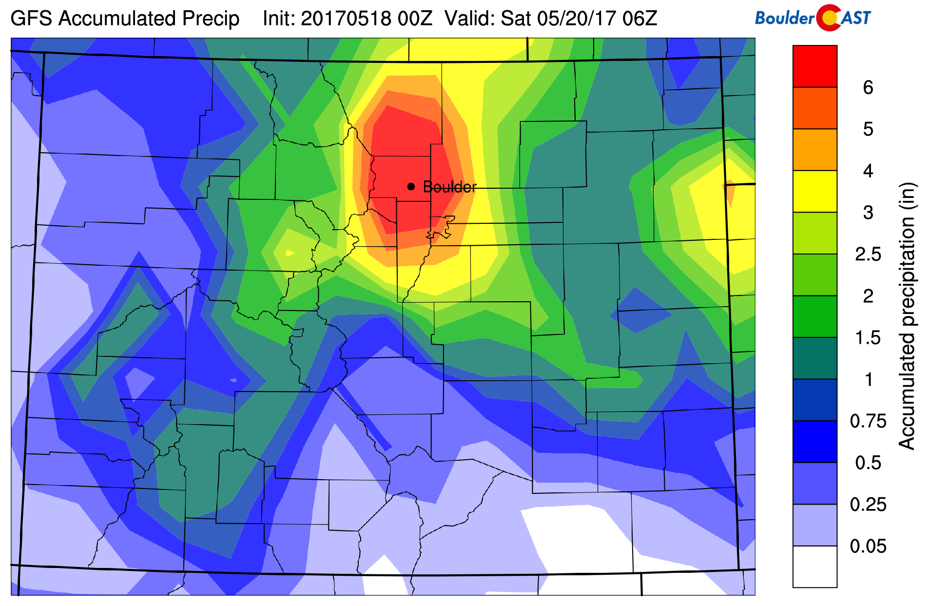
GFS total accumulated precipitation forecast for the event. 6″ would be a third of our annual average.
The one red flag this morning is the colder temperatures and lower snow levels upon wake-up. We’re running about FIVE degrees colder at the surface than models were projecting. If you recall yesterday’s post, we mentioned a shift of just three or four degrees could bring significant snow to the Plains as well. Alas, you see today’s predicament…
Short-range guidance from the HRRR suggests temperatures won’t budge from the mid-30’s across the Plains today. This means snow levels won’t be retreating upwards all that much, likely lingering around 5,500 feet through the day. This means areas close to the base of the Foothills, like Boulder and Golden, could remain snow through the day. Several inches of slush will be possible in these locations by rush hour.
We expect a bulk of the precipitation today to fall in the form of rain east of Interstate 25. A few wet snowflakes may mix in here and there during some of the more intense showers, but we don’t expect too much accumulation (less than an inch).
Later this evening as winds take on a more northerly component and the sun goes down. There is a very good chance now that temperatures will then become cold enough to support accumulating snow everywhere. We’re thinking this full change over will occur for everyone between 2:00 PM and 8:00 PM this evening. Any precipitation that falls afterwards will be all snow, but the question then becomes how much will the storm have left after this point? The GFS, Euro, and Canadian models project approximately anywhere from 0.5 to 1.5″. Assuming a soupy snow to liquid ratio of 6 to 1, this equates to about 3 to 9″ of accumulation (not including melting). The highest amounts will be west and north of Denver, especially along the base of the Foothills near Boulder.
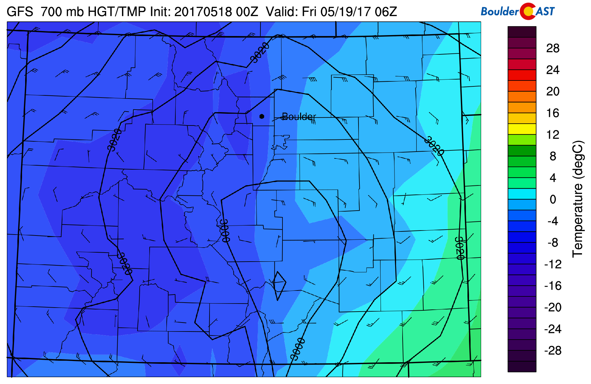
GFS 700 mb temperature and wind map for Thursday night at midnight.
Of course we also can’t forget the Foothills….it all snow up there! Historical snow amounts ranging from 2 to 5 feet in Boulder and Larimer Counties are still on track. There will be a lot of compaction and some melting, so don’t expect to see this much snow on the ground at any one time or location. This will be the amount measured on elevated surfaces or snowboards that are cleared off regularly (every 6 hours is the official procedure). During the heavier pushes of upslope today, snowfall rates could easily hit 2 to 3″ per hour.
Too bad Eldora isn’t open right now…
Snow showers will wind down Friday afternoon across the region.
Our updated snowfall forecast map is below. The biggest tweaks were made in areas right around the rain/snow line that will benefit from slightly colder temperatures, producing MORE overall snow. This includes the Foothills below 6,500 feet and the Plains west of Interstate 25 (Boulder, Golden, Broomfield, Lyons).
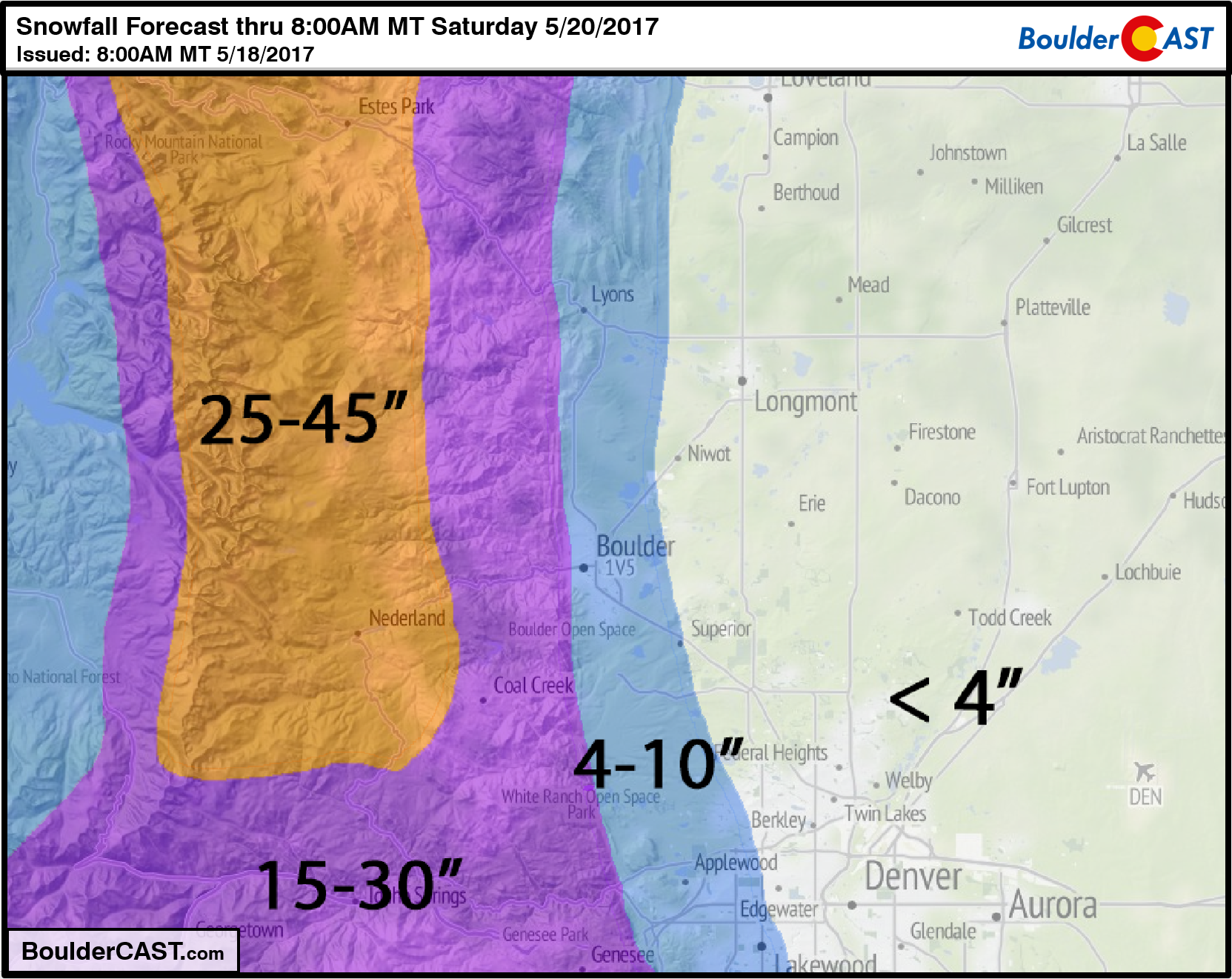
This storm is truly is going to be one for the record books! Not only for dumping four feet of snow in the Foothills, but for producing accumulating snow on the Plains this late in May. Even if only four inches of snow falls in Boulder, this event will still be nearly unprecedented in the historical record. Enjoy it, folks! Stay warm if you can….
Don’t be selfish…share our forecast with your friends!

.


Yep….of course it was colder than the models predicted. None the less, forecast update this morning should cover things. If you’re snow now, you’ll be snow until then end !
Totals coming out of the Boulder County Foothills are already approaching two feet as of lunch time Thursday!