In the wake of a gorgeous spring-like weekend, sunshine and above normal temperatures will continue for the week ahead. However, a cold and likely snowier pattern change is finally on the horizon. Read on for full details of our forecast, and a quick review of the toasty month of February.
In like a lion, out like a…groundhog?
After Boulder’s biggest snow storm in more than three years on Groundhog Day, the headline of February became the persistent ridge, which supplied above normal temperatures and abundant sunshine throughout the month. If you have been following along with us, the ridge should be no surprise, as we noted the likely pattern shift during the first few days of the month. By the middle of February, we even went as far to say that there would be no more snow on the Plains until March (busted, but just barely). When considering the El Nino statistics and analogs, this exceptionally warm and dry pattern makes a whole lot of sense.
How warm were we this month? With one more day to go (yay Leap Day!), 2016 will just round out the top 10 for warmest Boulder February’s, with an average high of 54.1 degrees. That is more than 7 degrees above normal. Judging by the monthly temperature anomaly map below, almost all of the United States had a “warm” February (sorry Florida).
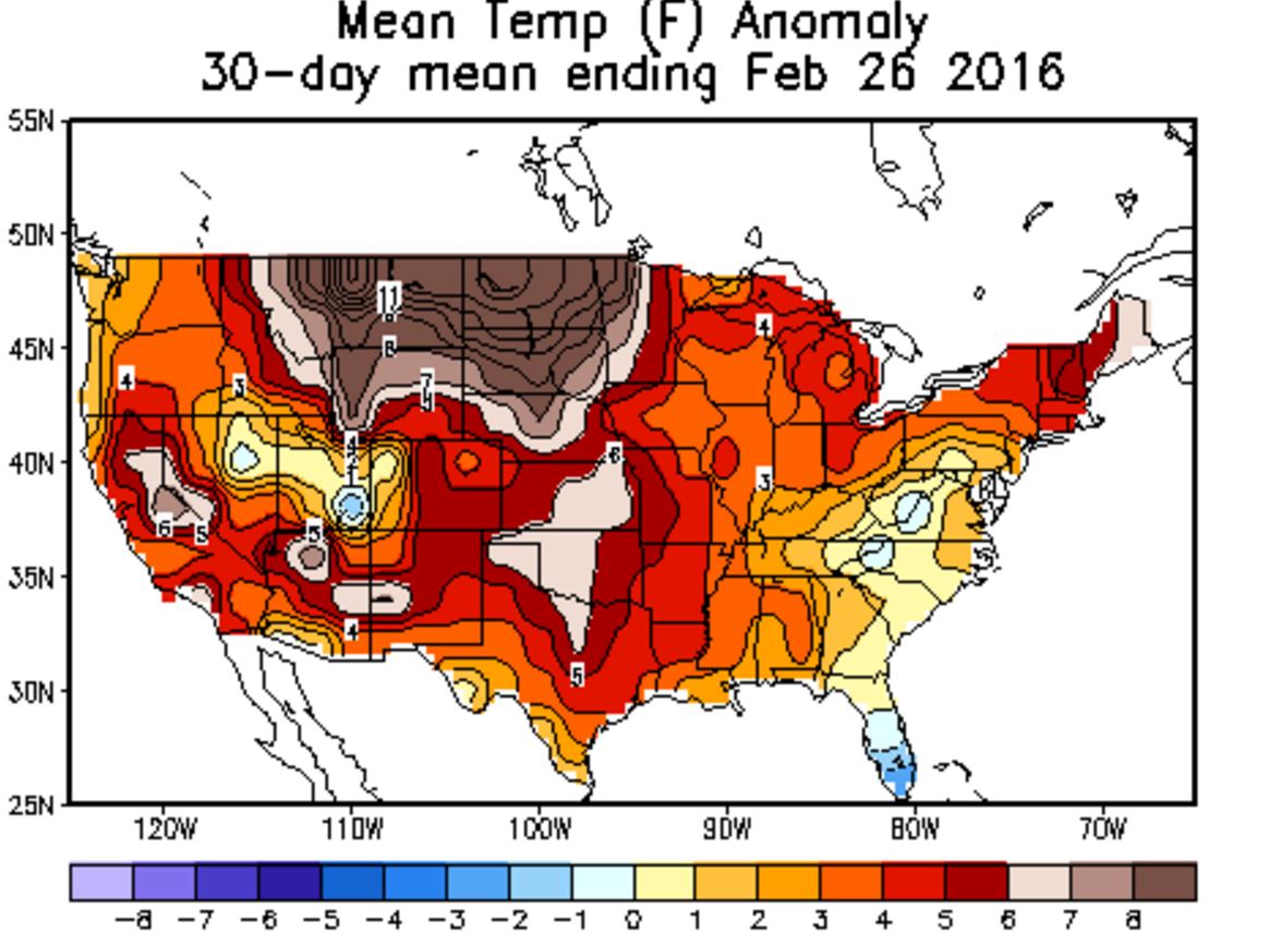
Mean temperature anomaly for the month of February. Ridiculous warmth across the central and northern Plains, including eastern Colorado.
Boulder will end the month with 21.8″ of snow and 1.44″ of liquid, both of which are more than double normal values. Ironically, this makes 2016 the 13th snowiest February in Boulder’s history, despite the warmth. Most of the Front Range is running well above normal for the month, a hefty portion of which came from the Groundhog Day storm (Feb 1-2).

February precipitation, given as a percent of normal | NOAA
Not surprisingly, as a consequence of the recent dry period, we are now behind on snow for the season (by just 2 inches). However, we do expect things to become more active as March progresses. Finally, we are seeing ensemble support for this, with cooler weather and a trough likely invading the Western USA by the middle of next week, with good agreement between the Euro and GFS.

Ensemble 500mb height forecasts for March 9, 2016 from the GFS (left) and Euro (right). This could be our most significant trough in more than a month!
Beating down that ridge
Let’s reel back in and focus on the week ahead. To get from our current ridging pattern to next week’s trough, the atmosphere is going to have to do a bit of work. Ridges don’t just beat themselves down, you know.
An active pattern will once again return to the region, with frequent and quick-moving, but ultimately weak, weather systems passing through Colorado. Each one will only offer a glancing blow to the ridge, but together, it may be enough to knock us out of the dry pattern by next week.
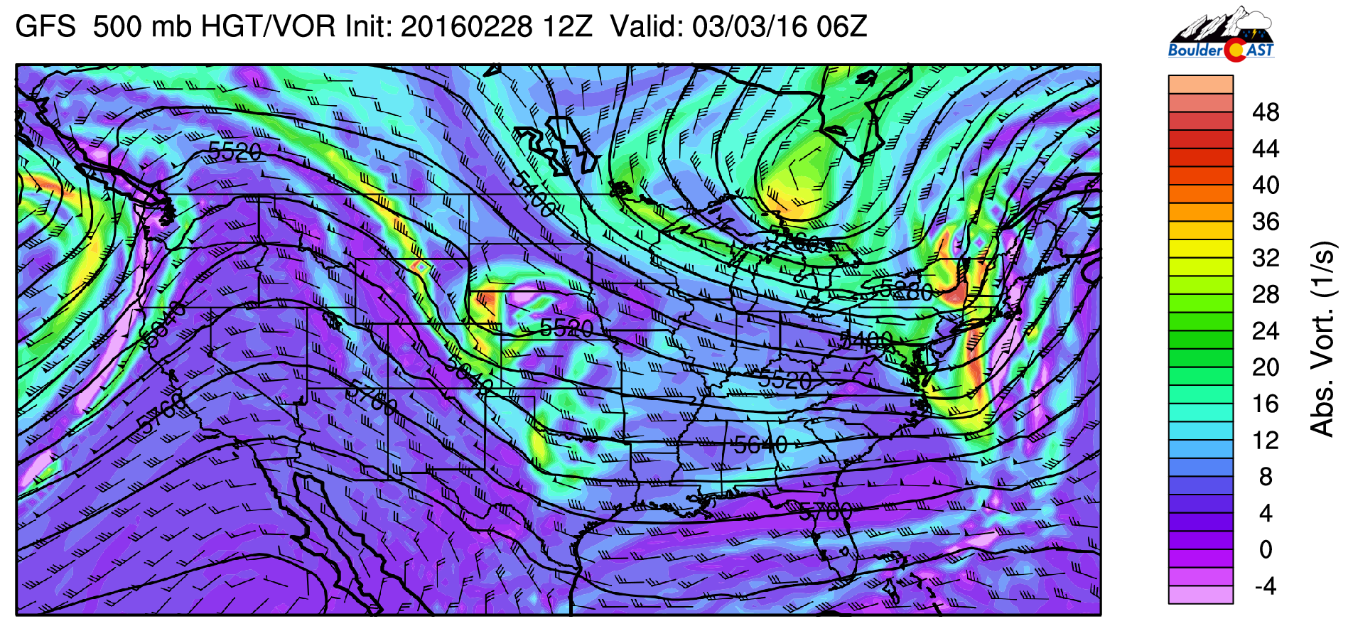
The current 500 mb map for Monday morning is shown below. We see a largely zonal flow pattern set up across the country, with relatively weak westerly flow across Colorado.
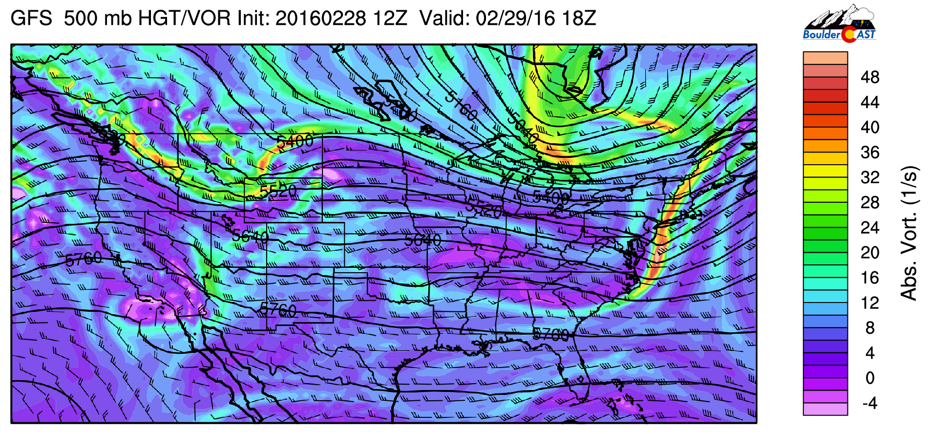
GFS 500 mb vorticity map for Monday
Our first weather system for the week is visible above in Idaho and Montana. It quickly slides southeast later today, bringing a cold front through NE Colorado in the early evening, with an even colder push later Monday night. Expect a mild morning and afternoon today, with temperatures in the low 60’s before the front passes. Precipitation will mostly be confined to the Mountains, but we can’t rule out a light rain shower on the Plains between 5pm and 3am. Snow totals will be light in the High Country, generally less than 4″. Best locales to see some accumulation will be the Central Mountains, near Vail and Beaver Creek.
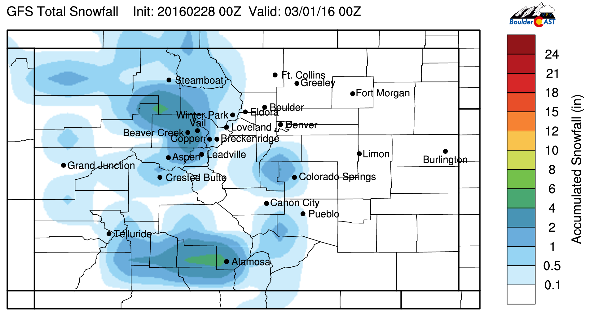
GFS snowfall forecast for Colorado through Monday. We’re only expecting light snow totals in the Mountains
A weak, west-east oriented jet will be overhead during late-day Monday. It could be a little breezy at times in the evening. Up to 45 mph in the higher terrain, 25 mph down low. This downslope will keep precip chances very low on the Plains this evening.
Ridging returns by Tuesday afternoon. With northwest flow aloft, temperatures will be cooler than Monday, but not significantly. Expect a mix of clouds and sun, with highs in the low to mid 50’s.
Another storm system quickly tracks along the top of the ridge embedded in the northwest flow for Wednesday. That system can be seen below, just clipping NE Colorado.
GFS 500 mb vorticity map for Wednesday night
It may produce some very light snow in the Mountains, but a bulk of the energy looks to remain too far east to have much of an impact. The northeast corner of the state will likely see a tad of light rain. Across the Denver Metro area, we’ll remain dry, but there will be another weak cold front passing through. The timing will likely change, but as of now, it comes through after sunset Wednesday evening. Ahead of this system, temperatures will rebound to near 60 degrees.
By Thursday, the ridge slides east, right over the state. We’ll once again see temperatures near 60 degrees, with partly to mostly sunny skies. Another weak system approaches to end the week. It looks to move through Friday night into Saturday morning. Once more, it will have little impact, with very light snow for the Mountains, and a weak cold front for the Plains. Friday will be very similar to Thursday for us.
Overall, a rather uneventful week ahead. Not great news for the skiers out there, but we do squeeze out at least one more full week of dry and spring-like weather across the Plains. Look for a better chance of some action next week. Enjoy Leap Day and the week ahead!
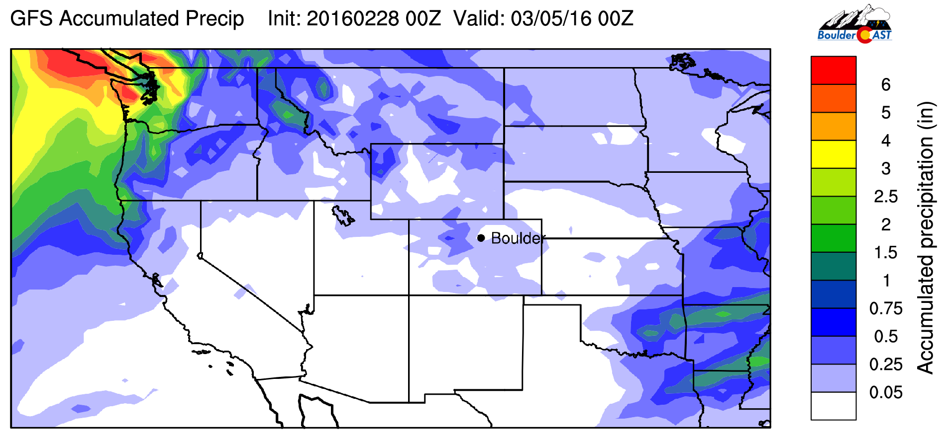
GFS forecast total accumulated precipitation through Friday evening. Not much happening under the ridge for the Central and Southern Rockies.
The Forecast:
Monday: Abundant high clouds. A few isolated rain showers (snow showers in Foothills) will be possible in the evening behind a weak cold front. Highs in the low 60’s across the Plains, low 50’s in the Foothills. Breezy in the evening with winds gusting to 40 mph in the Foothills, to 25 mph on the Plains.
Tuesday: Mostly sunny and cooler. Highs in the low 50’s across the Plains, mid 40’s in the Foothills.
Wednesday: Partly sunny and mild. Highs near 60 degrees for the Plains and upper 40’s in the Foothills.
Thursday: Partly sunny and mild. Highs in the low 60’s across the Plains and upper 40’s in the Foothills.
Friday: Partly sunny with increasing clouds by evening. Highs in the low 60’s on the Plains, with low 50’s in the Foothills.
High Country: Look for light snow during the day Monday with a few inches of accumulation. Light snow returns on Wednesday afternoon, with little to no accumulation. Another chance of snow on Friday, but the set-up is not all that favorable. Expect above normal temperatures with breezy west to northwest winds through the week.
Extended Outlook: Not much happening this week, but as we mentioned, were monitoring some big changes for next week. Middle of next week (around March 9) looks good for a storm somewhere east of the Rockies.
| Source | Mon | Tue | Wed | Thu | Fri |
|---|---|---|---|---|---|
| BoulderCAST | 61 | 55 | 62 | 62 | 64 |
| NWS | 61 | 51 | 60 | 62 | 64 |
| AccuWeather | 59 | 54 | 60 | 62 | 61 |
| The Weather Channel | 61 | 58 | 59 | 64 | 65 |
.
Last week’s recap:
Here are the results of last week’s forecast. First, the forecasts and observations from all of the sources:
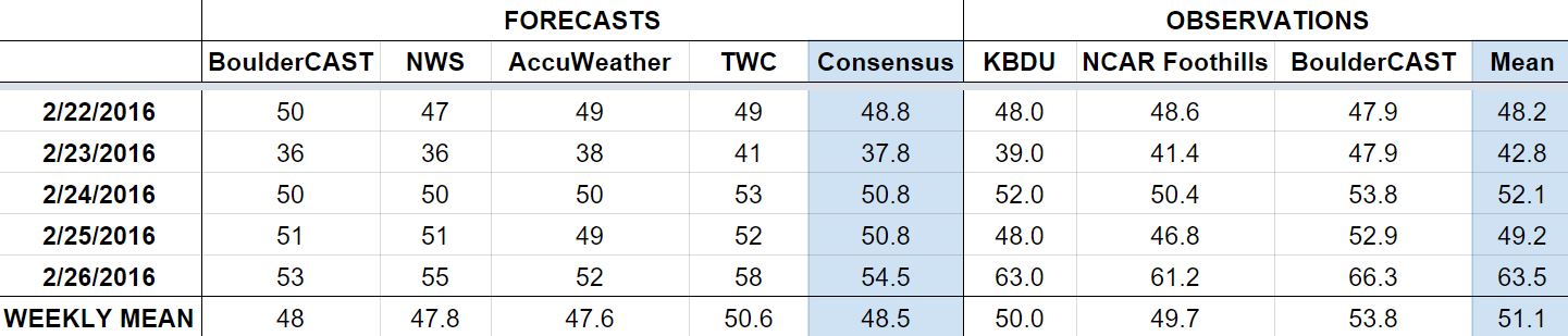
Last week began cool, with a light snow event Monday night. We were forecasting 3-5″ for Boulder. The official total was 5.2″ of snow. We then saw temperatures rebound back into the 50’s and 60’s to close out the week.
Let’s look at the error analysis. Shown below is the amount of degrees (in Fahrenheit) that each source was off from the mean observed temperature for Boulder. Positive values indicate the forecast was warmer than what actually occurred, while negative values arise from a forecast that was cooler than what was observed.
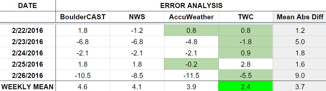
Another okay week for everyone, with low error for most of the week. Tuesday had 5 degrees of error, a result of models overplaying the cold air behind our snowy system. Friday had ths highest error, at a whopping 9 degrees, as temperatures soared to 64 degrees (forecast was 55 degrees). The ridge rebuilt a little quicker than anticipated.
The bottom row of the error table shows the weekly mean error for each weather outlet, a good measure for who was the best and more consistent “forecaster” for the week. First place goes to The Weather Channel, which is only their 4th first-place-finish in the last 34 weeks!


You must be logged in to post a comment.