After a chilly and exciting weekend (Go Broncos!), the week ahead will entertain the continuation of our recent weather pattern. Weather systems will be frequent, quick-moving, and weak, with the Mountains reeling in more snow. Seasonal and mostly dry conditions will dominate the Plains. Continue for full details.
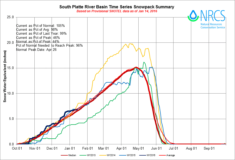
For as dry as it has been across the Plains, we have had a ton to talk about over the past few weeks. While the Plains haven’t picked up much, the Mountains have been doing quite well, sitting at 105% of average snowpack in the South Platte River Basin.
This week will continue that trend. For those across the lower elevations, remember that January is our driest month of the year. Thus far in 2016, we measured 0.24″ at BoulderCAST, which only puts us about a tenth of an inch below normal. Furthermore, under strong El Niño conditions, we would expect a relatively tranquil time in the middle of winter (as it has been). It isn’t until late February and March that things get statistically more snowy.
Our most recent shot of snow in the city was Friday night. We issued our forecast Friday afternoon, warning of snowy conditions mostly across the Mountains and also northeast of Denver. Even then, we expected most places on the Plains/Foothills to get only a trace up to two inches. At BoulderCAST, we measured a trace of snow.
Our original forecast map and post-storm snow totals are shown below.
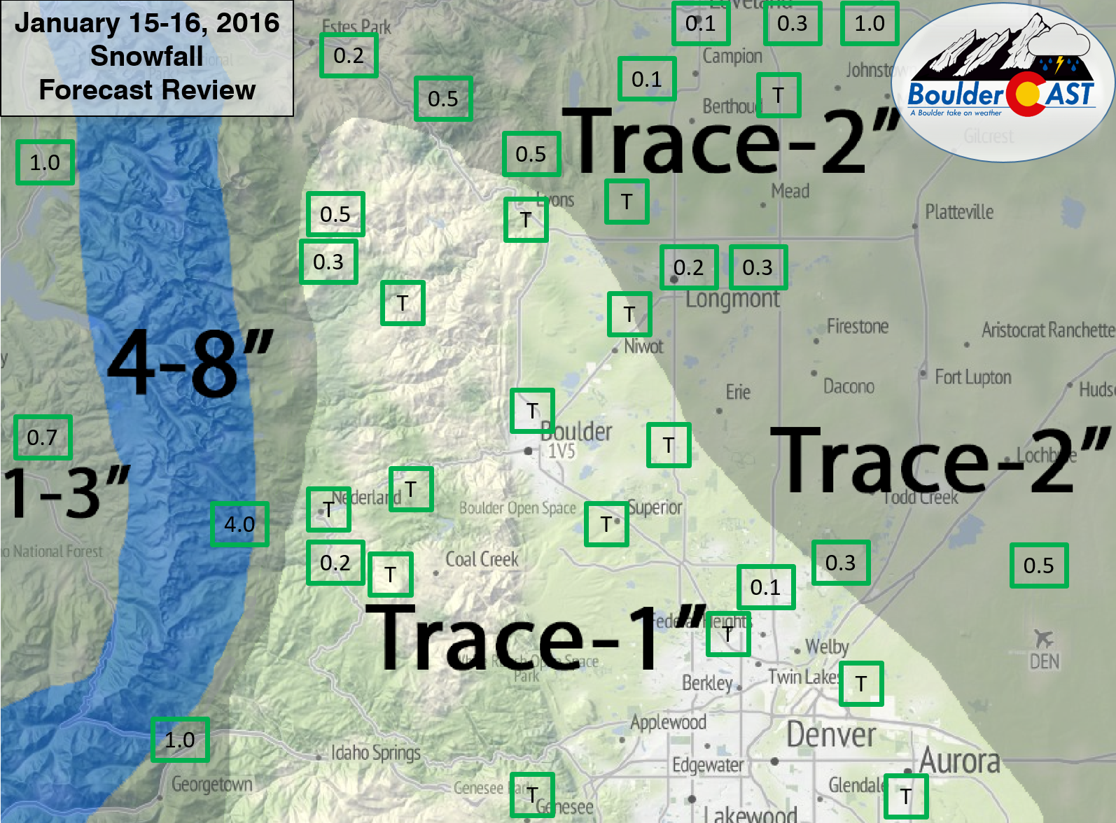
BoulderCAST Snowfall Foreast Review (January 15-16, 2016): Our original forecast snow total map, with the observed storm totals at each location contained in boxes. Green boxes indicate that the observed snowfall was within one inch of the given forecast range, while red ones were outside the scope of our forecast.
With very few observations in the western part of Boulder County, it is hard to say how well we verified there (as it always is). Our only report to go on, 4.0″, comes from Eldora Ski Resort just west of Nederland. Other ski resorts further south and west piled up 4-8″ by Saturday morning, and even more Saturday night. We’ll call that verified!
Moving to the week ahead, we see the pattern remain largely unchanged.
A few storms come ashore in northern California and swing east across Colorado. One arrives late Monday night, with a second quick to follow on Wednesday.
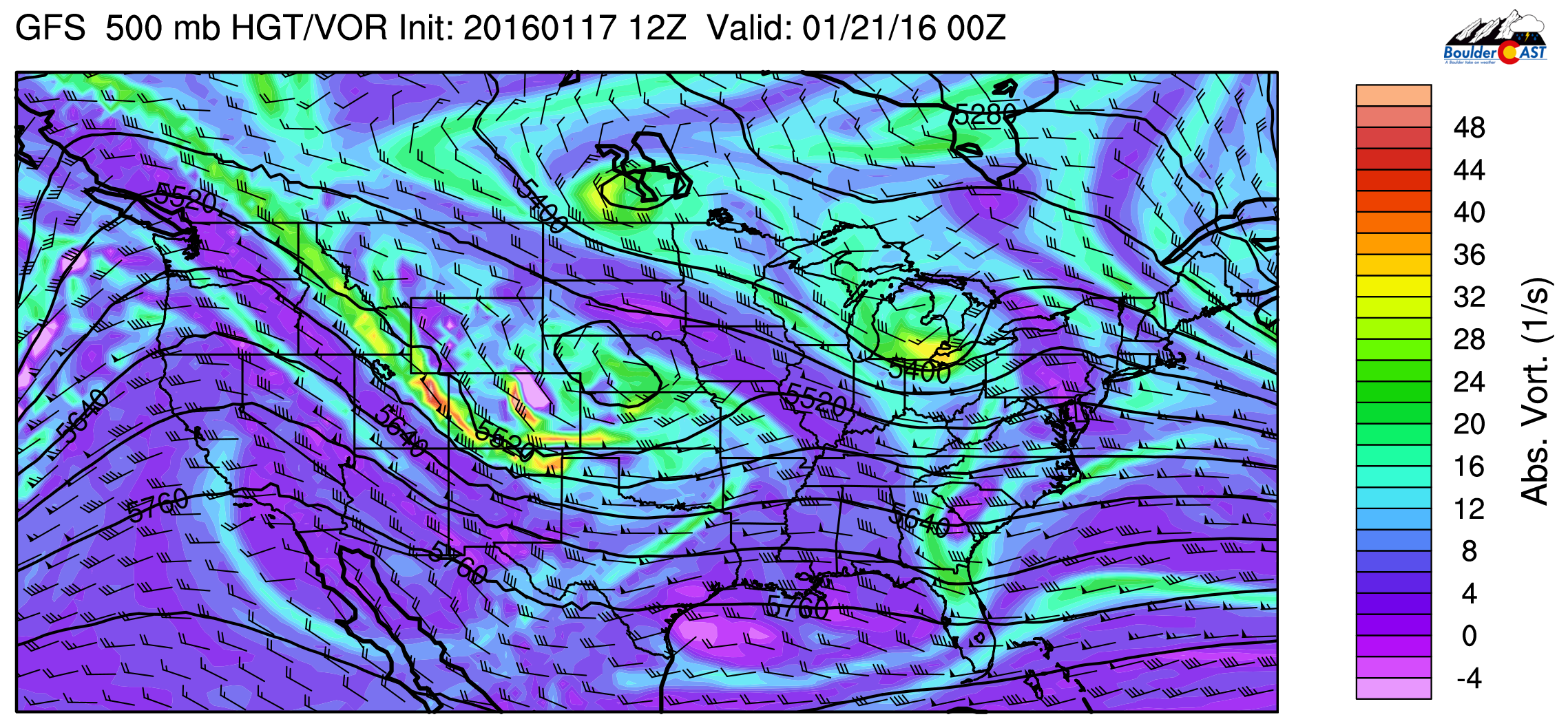
On Monday, we will be under the influence of an upper-level ridge (seen below).
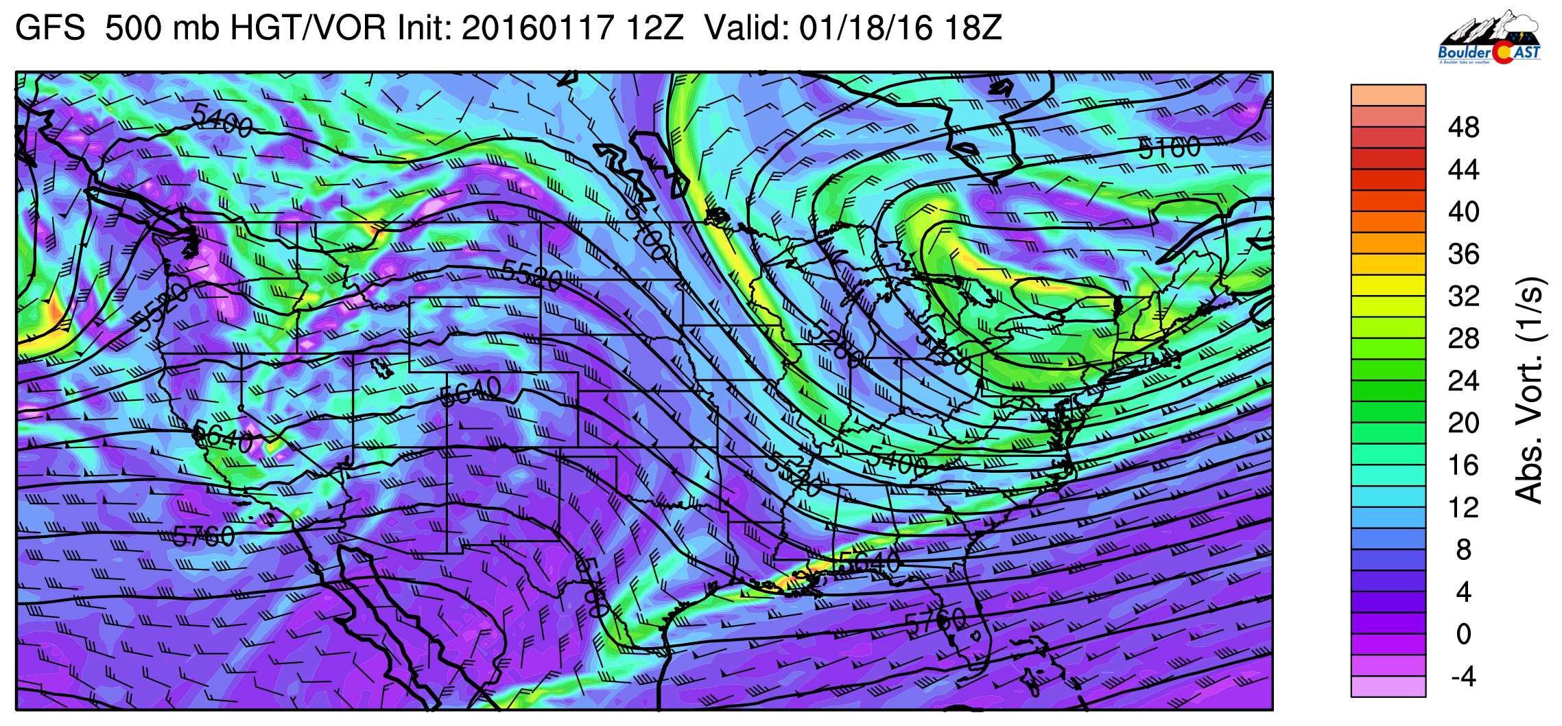
GFS 500mb vorticity map, valid at 11am today. Ridging is present over Colorado, but out next system is already ashore in California.
With west-southwesterly flow and light downslope, we’ll see a nice warm-up into the upper 40’s across the Plains with mostly cloudy skies, compliments of mid/high level moisture.
Our first weather systems rapidly moves through Monday night. Light snow will begin in western Colorado Monday evening, spreading into the Front Range Mountains after midnight. As quickly as it starts, it will end, likely by mid to late morning Tuesday. Snow totals in the High County should be light, less than three inches, mostly west of the Divide. On the Plains, we aren’t expecting much snow with this storm, just a few flurries. The timeframe for Plains flurries would be between 2am and 10am Tuesday morning. After morning clouds, skies will begin to clear in the afternoon with temperatures in the low 40’s behind a weak cold front.
A second and slightly more potent storm system arrives for Wednesday.
GFS 500mb vorticity map, valid Wednesday afternoon with another wave moving across Colorado
It has decent moisture and is larger than most recent waves, with snow likely across most of the Mountains Wednesday morning through Thursday morning. While we don’t see anything that indicates much snow at this time for the Plains, the models want to develop a weak surface low in southeast Colorado Wednesday evening, which does bear watching.
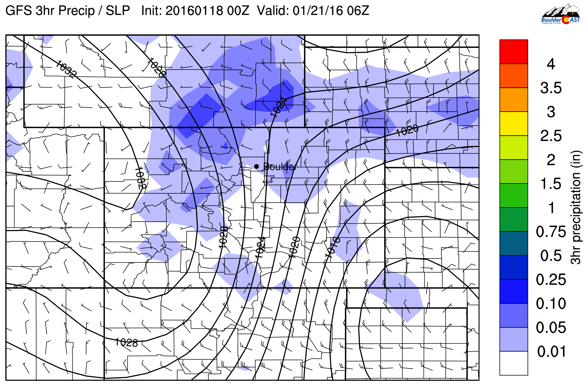
GFS pressure and precipitation forecast for Wednesday night. Shown is a surface low in SE Colorado and some post-frontal precip across our region
Depending on the exact location and strength, this could help snow get going in the lower elevations. Regardless, it will bring a cold front through NE Colorado in the evening hours. For now, snow chances are marginal and accumulations would be very light. Highs will be in the mid 40’s.
Thursday and Friday will see sunshine return with a broader ridge overhead. Temperatures will remain seasonal, in the low 40’s on Thursday, warming back to near 50 degrees by Friday.
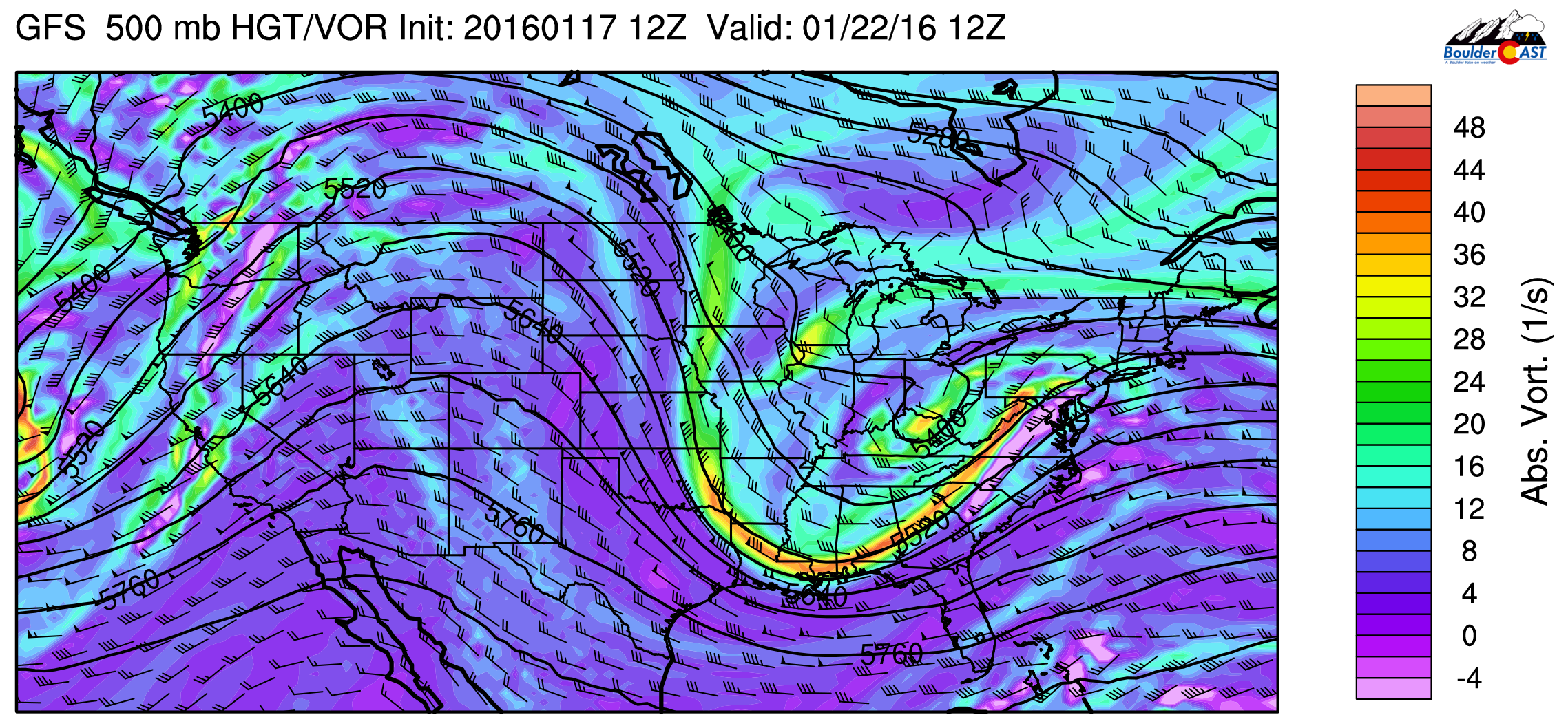
GFS 500mb vorticity map for Friday morning. The large ridge across the Rockies will bring dry and warm(ish) conditions to Colorado.
Don’t let your guard down though. Our next series of disturbances look to arrive just in time for the weekend! Stay tuned.
The Forecast:
Monday: Mostly cloudy and mild. Highs near 50 on the Plains, with low 40’s in the Foothills.
Tuesday: Cloudy with isolated flurries in the morning. Clearing skies through the afternoon. Highs near 40 across the Plains with low 30’s in the Foothills.
Wednesday: Increasing clouds and a slight chance of snow in the evening. Highs in the mid 40’s across the Plains, with mid 30’s in the Foothills.
Thursday: Mostly cloudy in morning with clearing skies in the afternoon. Cooler with temperatures in the low 40’s on the Plains and mid 30’s in the Foothills.
Friday: Sunny with moderating temperatures. Highs in the low 50’s on the Plains and mid 40’s in the Foothills.
High Country Forecast: Two shots of snow. The first will be Tuesday morning, with light accumulations. The second round arrives Wednesday morning, persisting into Thursday morning. 6+” will be possible for areas above 10,000 feet near and west of the Divide.
Source
Mon
Tue
Wed
Thu
Fri


BoulderCAST
47
40
47
41
51


NWS
47
42
42
41
50


AccuWeather
44
44
45
42
52


The Weather Channel
46
42
43
43
53
Last week’s recap:
Here are the results of last week’s forecast. First, the forecasts and observations from all of the sources:
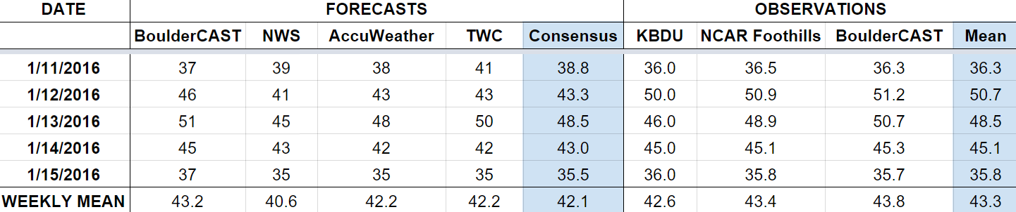
Last week had seasonal temperatures and a fair amount of sunshine. We had a cold front move through on Thursday, bringing snow and cooler temperatures to end the week. We mentioned the chance of snow on Friday, which did verify.
Let’s look at the error analysis. Shown below is the amount of degrees (in Fahrenheit) that each source was off from the mean observed temperature for Boulder. Positive values indicate the forecast was warmer than what actually occurred, while negative values arise from a forecast that was cooler than what was observed.
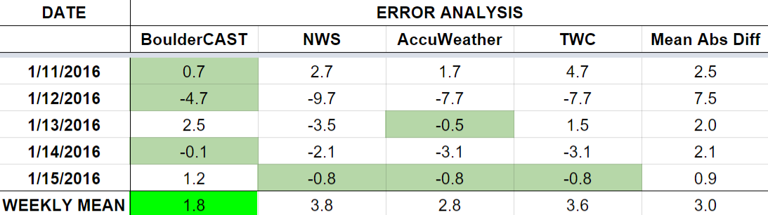
Overall, forecasts were swell through the week. The worst day was Tuesday, where downslope conditions warmed us much higher than forecast (51, well above the forecast of 43).
The bottom row of the error table shows the weekly mean error for each weather outlet, a good measure for who was the best and more consistent “forecaster” for the week. BoulderCAST definitively takes first place this week, with 1.8 degrees of error. This is a full degree above second place AccuWeather. This is the largest separation to date between first and second place. The NWS continues in last place for the fifth straight week.


You must be logged in to post a comment.