After a lengthy cold stretch which brought more snow to Colorado and other parts of the country, this week we are in store for moderating temperatures, with the potential for low 50’s come Wednesday, all thanks to the heart of the cold air retreating back to Canada and the Northeast. Colder weather and the potential for snow returns late Friday and for the upcoming weekend. What are the specifics for the week? Read on to find out more!
Last week’s snow recap
Let’s first take a look back at 2016’s first snowfall event from last Thursday into Friday (January 7-8, 2016). Our initial forecast from Wednesday night called for 2-4″ across most of the area, with a little less north of town and more into the higher Foothills. By the time the snow finally tapered off Friday afternoon, we recorded a storm total of 3.2″ at BoulderCAST, while the official site in Boulder only measured 2.5″.
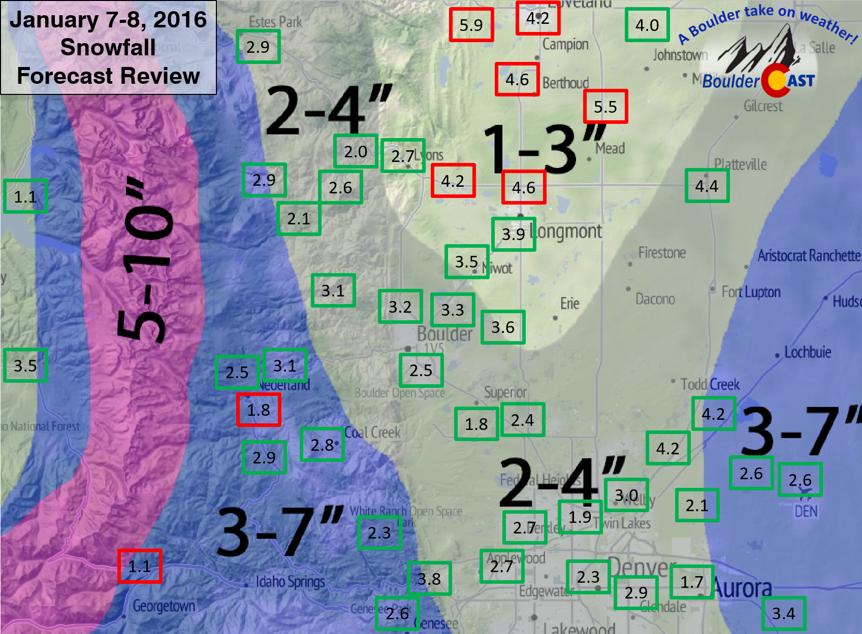
Snowfall Foreast Review (January 7-8, 2016): Our original forecast snow total map, with the observed storm totals at each location contained in boxes. Green boxes indicate that the observed snowfall was within one inch of the given forecast range, while red ones were outside the scope of our forecast.
Overall, our forecast was great. The only bust was in the area stretching from Longmont into Loveland, where a few localized heavy bands of snow formed Thursday evening and remained, for the most part, stationary. This type of banding was not expected over this region, but instead over the area east of Denver on Thursday afternoon (where we had 3-7″ forecasted, by DIA). The heavy band east of Denver did develop, but did so before the truly cold air arrived. Thus that region experienced a lot of melting and only reached the low end of our forecast range there.
BoulderCAST definitely bested the NWS and other weather outlets, whom predicted 3-7″ for the entire Denver area and 5-10+” for the Foothills. Roads were a little slick, but not terrible for Friday morning’s commute. It seems the road crews had a handle of things thing time around. Let’s hope this continues as we head into our “snowy” season.
We hope you enjoy these brief recaps of our snow events, particularly the maps like the one above that we so often show. It not only allows us a chance to reflect on the good and the bad of our forecast, but also gives you an idea of snow amounts from around the area and where your neighborhood might fit in. We will continue the analysis through the winter season and at the end, summarize the year and our forecasts in a single concise post.
So what’s going on in the atmosphere this week?
We have been in a cold stretch for really the past several weeks, with snow cover on the ground at least since the middle of December. This cold pattern is about to take a short break…
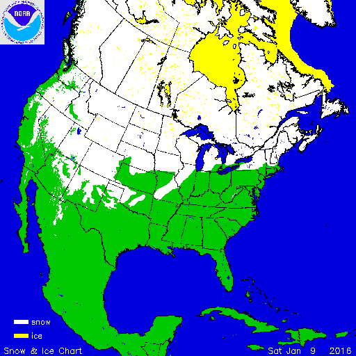
Current U.S. and Canada snow cover as of Saturday November 9th, 2016
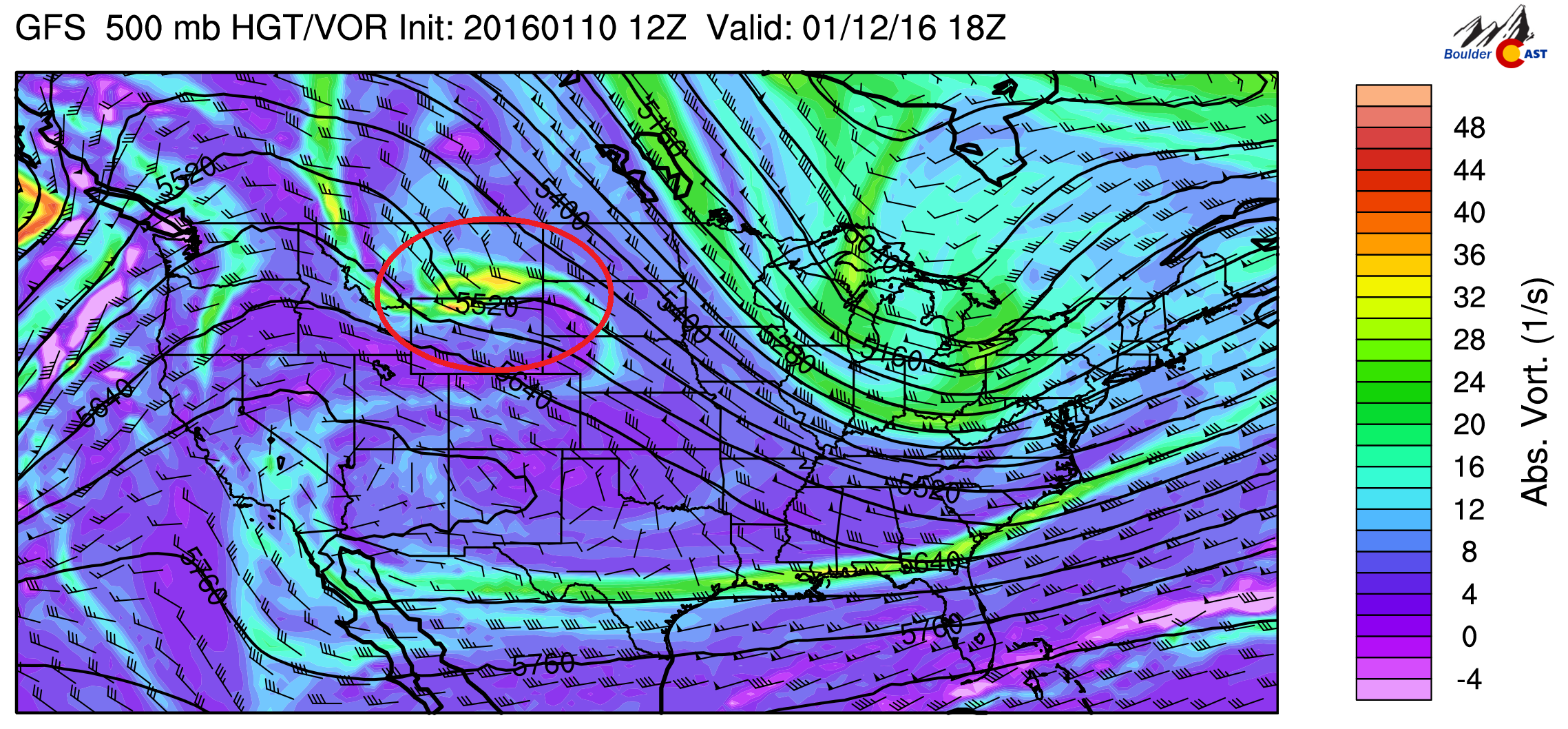
Below shows the 500 mb absolute vorticity for this afternoon from the GFS. Indicated in red in the region of colder air, located primarily over the Great Lakes and northeastern United States. This cold air will continue to push east of Colorado through the week. Over our region, northwest flow is present. However, an upper-level ridge is centered over Nevada and Utah. This will spell out clearing and rising temperatures this afternoon into the upper 30’s.
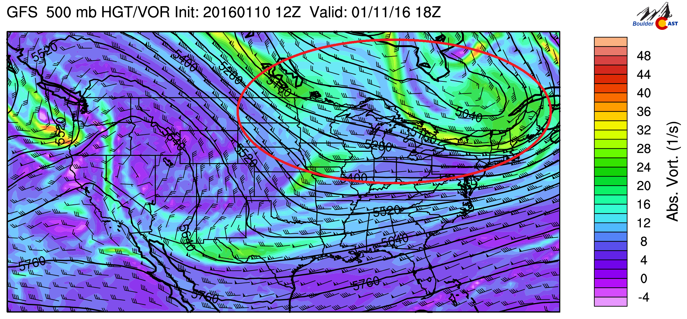
500 mb vorticity for this afternoon from the GFS
On Tuesday, general northwest flow can be seen across the northeastern US, with Colorado on the western edge of this flow thanks to a ridge of high pressure over southern Nevada. Circled in red is a weak mid-level shortwave diving southeast out of Montana. This system will clip the eastern part of our state tonight, but won’t do much other than introduce some mid and upper-level clouds in the evening and early Wednesday. Expect highs to warm further into the mid 40’s.
500 mb vorticity for Tuesday from the GFS model
The warmest day of the week looks to be Wednesday.The ridge of high pressure that was over Nevada will push east into western Colorado, as evident below. Meanwhile, another storm system will move onshore into California.
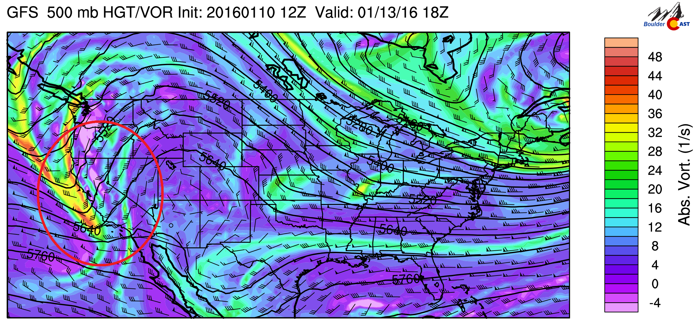
500 mb vorticity for Wednesday from the GFS model
Below shows the 700 mb height and temperature pattern from the GFS for Wednesday. Over Colorado, temperatures rise above freezing for the first time in a while. Circled in black is the cold air, which has retreated back into Canada, as discussed earlier. More cold air, however, will move back into Colorado by Friday and the weekend. With the rising 700 mb temperatures, its certainly likely we could see the low 50’s in Boulder, which (outside of January 5th where we barely touched 50), we haven’t really seen since December 22nd.
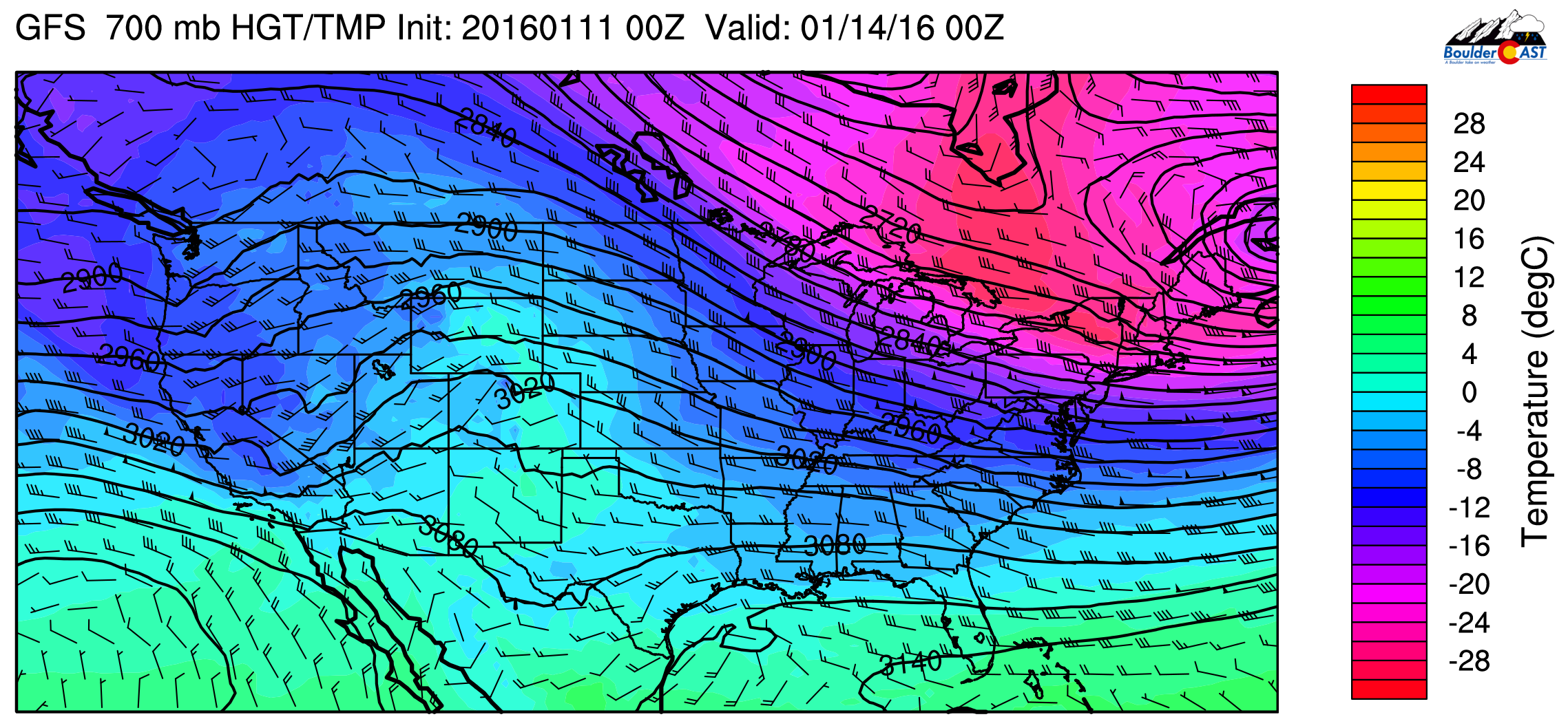
GFS 700 mb heights and temperature for Wednesday
The storm on the west coast will bring more precipitation to California, including the Sierras. The GFS shows accumulated amounts between 1 and 3 inches, which will further increase snowpack in the mountains there. This appears to be another solid storm for the west coast.

GFS Accumulated precipitation ending Thursday morning
Friday is a transition day with colder air from Montana diving southward. The models are a little in disagreement with where the cold air will release starting late Friday and over the weekend. The ECMWF indicates the cold air entrenched from Colorado through the Midwest, while the GFS depicts the coldest air clipping eastern Colorado. These two differences will likely have an impact on the forecast highs on Friday and the weekend. Shown below is a plot from the Climate Prediction Center at NOAA indicating the Arctic Oscillation (AO) index and geopotential height anomalies over the North Pole since September 2015. The AO index is a measure of the strength of the polar vortex in the stratosphere. Positive values indicate a strong vortex over the Arctic, while negative values indicate a weakening. Below shows that in the past week (area circled in red), the AO shifted to a negative phase, with positive height anomalies in the atmosphere (top plot). This weakened polar vortex indicates that a cold air outbreak is likely over the U.S. in the coming week and weekend. The northeast U.S. looks to be in a cold pattern this week after a very warm winter for them so far, but its possible Colorado will see this as well for the upcoming weekend.

Arctic Oscillation index and geopotential height anomalies in the upper atmosphere since September last year.
Below shows that the cold air dives south again by Saturday, with 700 mb temperatures falling well below freezing.
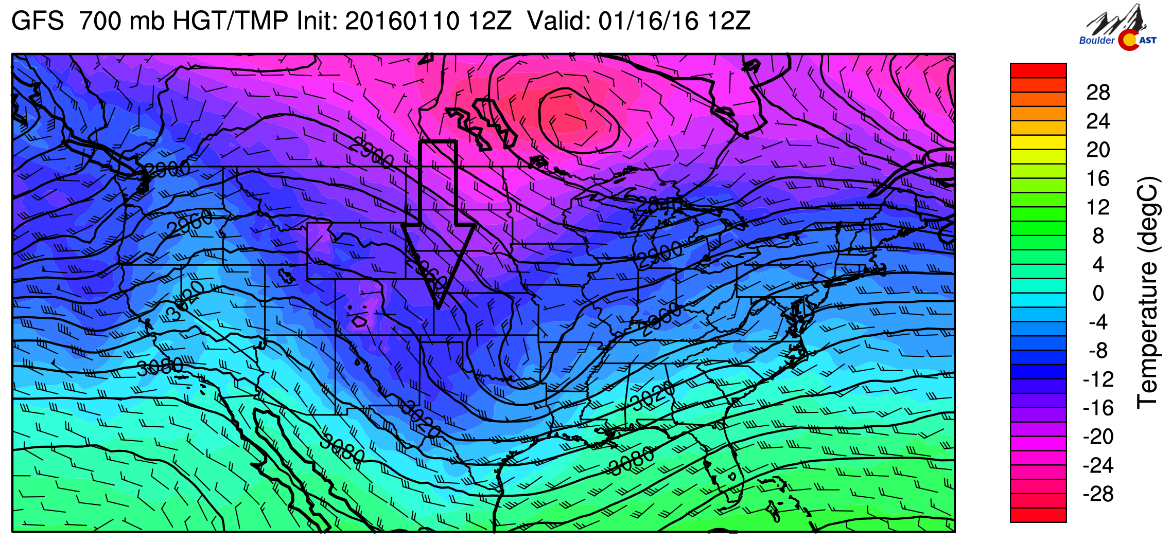
GFS 700 mb temperature for Saturday
Lastly, the forecast Friday will feature a storm system to watch that could bring snow again to the High Country and possibly Boulder as well, starting Friday evening. Circled in red is a decent shortwave coming out of Wyoming and Utah, which will likely be producing upslope in the mountains.
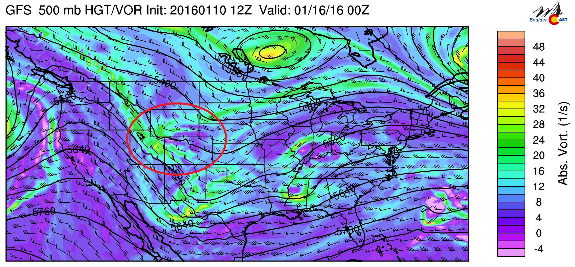
GFS 500 mb vorticity for Friday night
With cold air moving back in, it looks to be another snow-maker. But the storm is not very strong, and any amounts look to be on the light side for Boulder, as shown in the below GFS total snowfall map. We will certainly update you as we get closer to the event later in the week. The favored areas will be the mountains, with certain ski resorts possibly seeing 6″ of snow, just in time to please the skiers for the holiday (MLK Day) weekend.
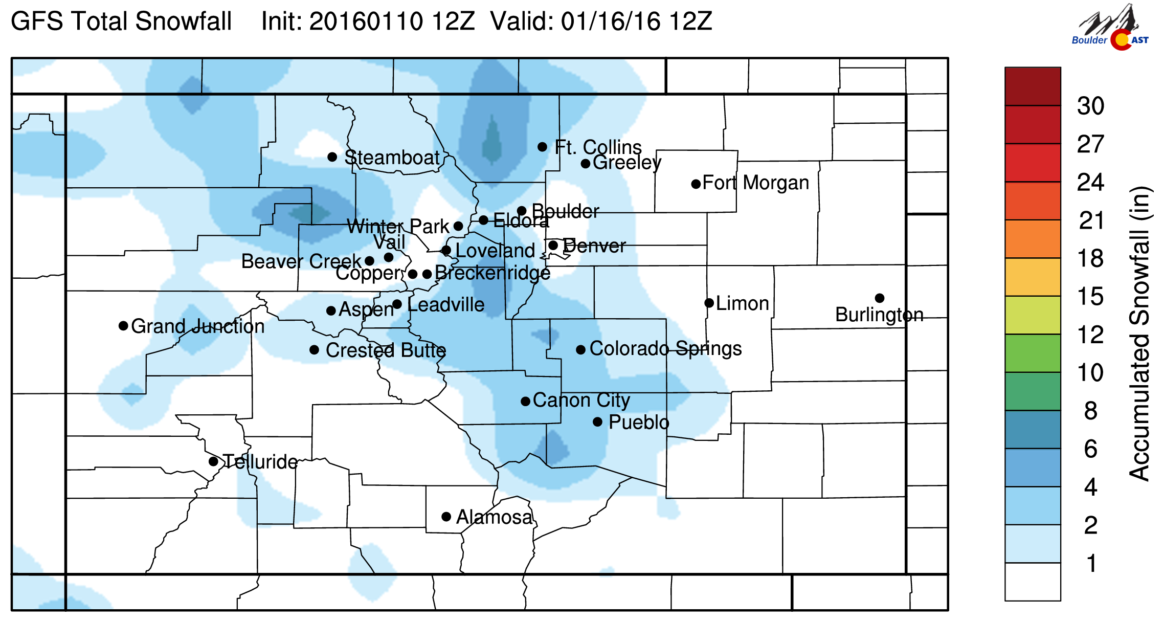
GFS total snowfall ending Saturday morning
The Forecast:
Monday: High clouds streaming in from the north. Mostly cloudy. Highs in the upper 30’s across the Plains, low 30’s in the Foothills.
Tuesday: Mostly sunny and pleasant. Highs in the mid 40’s across the Plains with upper 30’s in the Foothills.
Wednesday: The warmest day of the week. Lots of sunshine, warmer, with highs in the low 50’s across the Plains and low 40’s in the Foothills.
Thursday: Sunny skies. Highs topping out in the mid 40’s on the Plains and upper 30’s in the Foothills.
Friday: Increasing clouds, with a chance of snow in the late evening and overnight. Highs in the mid to upper 30’s on the Plains and low 30’s in the Foothills.
High Country Forecast: Weather looks sunny and tranquil across the High Country through Thursday with no major weather systems to impact the area. On Friday and the weekend, a shortwave approaches with snow likely Friday and Saturday, with 3 to 6 inches of snow possible for the ski resorts.
Extended Outlook: Colder air looks to entrench itself across Colorado for the weekend and early next week. The storm track remains pushed to the south, with a few storm systems to impact the state. However, these storms do not look major at the moment.
Source
Mon
Tue
Wed
Thu
Fri


BoulderCAST
37
46
51
45
37


NWS
39
41
45
43
35


AccuWeather
38
43
48
42
35


The Weather Channel
41
43
50
42
35
Last week’s recap:
Here are the results of last week’s forecast. First, the forecasts and observations from all of the sources:

Last week had warmer temperatures and lots of sunshine. We had a cold front move through on Thursday, bringing snow and cooler temperatures to end the week. We mentioned the chance of snow on Friday, which did verify.
Let’s look at the error analysis. Shown below is the amount of degrees (in Fahrenheit) that each source was off from the mean observed temperature for Boulder. Positive values indicate the forecast was warmer than what actually occurred, while negative values arise from a forecast that was cooler than what was observed.
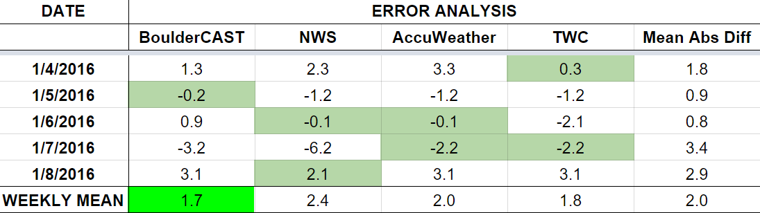
Overall, forecasts were right on through the week. The worst day was Thursday, but even then was only 3 degrees of error averaged across all outlets. A little surprising considering the uncertainty we had for the end of the forecast period (Friday).
The bottom row of the error table shows the weekly mean error for each weather outlet, a good measure for who was the best and more consistent “forecaster” for the week. BoulderCAST squeaks into first this week with 1.7 degrees of error, just edging The Weather Channel. The NWS keeps last place for the fourth week in a row. Sad day.


You must be logged in to post a comment.