
The weather across our region has been relatively uneventful over the course of the last month, with much of the West sitting beneath a broad, upper-level ridge and monsoon moisture hard to come by. That changes this week! The week ahead will showcase a, dare we say, (early) fall-like weather feature that will bring a big cool down and a good chance of rain (and possibly severe weather) to Boulder County. However, 90s will make an reappearance at some point. Read on to find out when!
Temperatures on Saturday, August 15 were the warmest in all of 2015, soaring to the upper 90s and low 100s across the Plains. Here are some of the readings observed around the area (in degrees Fahrenheit):
- Longmont Airport: 102
- Erie Airport: 100
- Thornton: 99
- BoulderCAST: 99
- Boulder Airport: 99
- Arvada: 99
- Denver International Airport: 98 (tied record high)
- Boulder (Official NWS measurement): 96
- Broomfield Airport: 95
Boulder got very close, but didn’t actually exceed 100 degrees! We were ever-so-close, but a cool outflow boundary plowing southward from a thunderstorm near Lyons knocked our temperature down from 99 to 92 in just twenty minutes around 3:30pm. Clouds filled the sky afterwards, preventing any potential rebound. Since August 1st, we have been climatologically trending downwards in temperature. At this point, the chance of reaching 100 degrees in Boulder in 2015 is very unlikely. Historically, after August 17th, 100 degrees has only been achieved twice, most recently on September 2, 1983. Though, we are sure many of you won’t mind not surpassing the century mark this summer!
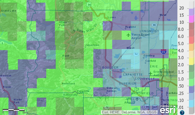
Last week also saw the culmination of Boulder’s dry streak, ending at 24 days when Friday (Aug 14th) recorded 0.01″ of rain! Through August 16, we are up to 0.16″ of precipitation for the month at BoulderCAST (0.11″ at official NWS site). Seen on the map below, depicting our August 2015 precipitation-to-date, most of the Plains have received 0.5″ or less of rain, while the higher terrain has fared at tad better, with 0.5-2.0″ being common.
We will see some drastic changes in our weather this week, as a potent upper-level trough approaches northern Colorado on Monday. A shortwave feature ahead of the trough should provide enough lift and instability to produce scattered thunderstorms over Boulder County Monday, during the late afternoon and evening hours.
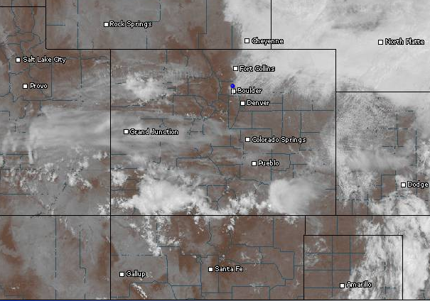
Current satellite image over Colorado, as of 11am Monday. Notice the extensive cloud deck spreading east to west into Denver.
Atmospheric conditions over the Front Range will be conducive to produce a few severe storms as well, with moderate CAPE and vertical shear. The biggest threat will be large hail and isolated tornadoes, mainly east of Interstate 25, south of Denver. Boulderites need to be cautious today as well. The best chance of severe storms in Boulder County will be between 4 and 9pm. We are skeptical of the severe threat for now, as temperatures need to climb into the low 80s to break the cap. With cloud cover around, we are not convinced this will be possible. However, added lift from outflow boundaries may be sufficient to fire storms in the cloudier spots. Regardless, stay aware out there! After midnight this evening, storm chances will decrease drastically as the energy flows eastward, thus ending the severe threat this week for Colorado.

The High-Resolution Rapid Refresh modeled reflectivity, valid at 7pm Monday, showing a few supercells developing across the Front Range. Don’t pay too much attention to the details (i.e. exact supercell location). Just be aware that the potential does exist for them to form in and around eastern parts of Boulder County.

Severe weather outlook for Monday, placing most of eastern Colorado at “Slight Risk” for severe storms | Climate Prediction Center
Did you notice the drastic drop in visibility today? The change in surface flow direction and recently-spawned wildfires in northwest portions of our state will produce smoky conditions across our region that could persist into Wednesday.
For Tuesday, the best news comes in the form of a cold front that pushes into northeast Colorado during the early morning hours. Northerly flow and spotty cloud cover will see temperatures struggle to reach 70 degrees, about 15 degrees below average! Most of our area should remain dry as the upper-level trough axis has already passed, leaving behind a fairly stable airmass. However, we can’t rule out the possibility of an isolated shower or thunderstorm for areas in and near the Foothills.

GFS 500mb vorticity map, valid at 6pm Tuesday. Conditions across eastern Colorado are relatively calm, with the trough axis already passed.
Overnight Tuesday into Wednesday morning, a shortwave feature on the backside of the trough clips northeast Colorado with moist but weak upslope flow (see below). This, combined with the overhead presence of a jet streak, could produce some light shower activity in and near the Foothills. With the cool air in place, snow may mix in in the higher Foothills. Little accumulation is expected, an inch at most. Furthermore, if skies can clear briefly before sunrise, parts of the Plains may refreshingly dip into the upper 40s Wednesday morning as well. By noon, things should be drying out, with partly cloudy skies for the rest of the day. Wednesday will remain cool once again, with high temperatures in the mid 70s across the Plains.

GFS sea-level pressure and precipitation map, valid at midnight Tuesday evening. Notice the light precipitation forecast for the Front Range.
Thursday will see things begin to warm up, as the trough and cooler air mass pulls away and our upper-level flow becomes more zonal (west-northwesterly). Remember it is still August; hot temperatures are only a day away! Thursday will remain mostly dry, with just a slight chance of an isolated storm over the higher terrain. Temperatures will rebound back into the upper 80s.
Friday will see further warming with slight upper-level ridging over our region ahead of the next storm system (see below). Expect highs to top out in the low 90s, and a slightly better chance of storms, once again, mostly over the Mountains and Foothills. The heat will be short-lived, as our next cold front is slated to move through over the weekend.
GFS 500mb vorticity map for North America, valid at 6pm Friday. Notice the slight ridging over New Mexico into Colorado, and our next storm system diving through Washington state.
August has been very hot and dry, with above normal temperatures and way below normal precipitation, compliments of a largely M.I.A monsoon. Mother Nature has quite a bit of work to do to fulfill the cool and wet outlook for August.
The Forecast:
Monday: Increasing clouds with scattered afternoon thunderstorms developing. There is a slight risk that some of these storms could become severe for the Plains of Boulder County, with large hail and weak tornadoes being the biggest threat. Highs will reach into the upper 70s on the Plains, with mid 70s in the Foothills. Smoke from regional wildfires will create poor visibility.
Tuesday: Cooler with partly cloudy skies. Widely isolated storms may develop in the afternoon over the Foothills, but dry on the Plains. Some low clouds and light showers are likely after sundown. High temperatures will reach only into the low 70s on the Plains, with mid 60s in the Foothills.
Wednesday: Cooler with isolated morning showers/mist. Some wet snow may mix in with the rain in the higher Foothills and Mountains, with up to one inch of accumulation. Drier conditions with clouds breaking up after noon. The Plains will only warm into the mid 70s, with 60s in the Foothills.
Thursday: Mostly sunny, warmer and dry, with just a slight chance of storm in the higher terrain. Highs will rebound into the upper 80s on the Plains, upper 70s in the Foothills.
Friday: Hot with increasing clouds and isolated afternoon storms ahead of our next storm system. High temperatures near 90 on the Plains, with low 80s in the Foothills.
Source
Mon
Tue
Wed
Thu
Fri


BoulderCAST
76
73
76
89
91


NWS
82
73
74
86
89


AccuWeather
79
78
76
89
92


The Weather Channel
77
74
74
87
90
Last week’s recap:
Here are the results of last week’s forecast. First, the forecasts and observations:

The consensus was for a cool beginning to the week, with a good chance of rain on Monday and Tuesday. Wednesday through Friday were expected to be drier and see temperatures rebound back into the 90s.
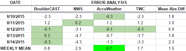
Now the error analysis. Shown is the amount of degrees (in Fahrenheit) that each source was off from the mean observed temperature for Boulder. Positive values indicate the forecast was warmer than what actually occurred, while negative values arise from a forecast that was cooler than what was observed.
—
If you haven’t already done so, follow us on Twitter or Facebook for frequent weather updates and subscribe to the site to get these posts automatically delivered to your email box (enter your email in the sidebar widget to right).


You must be logged in to post a comment.