Monsoon moisture returns for the first half of the week, after a relatively dry August so far. Temperatures will start off cool in the 80’s with gradual warming into the low 90’s by Friday. The annual Perseid meteor shower is slated to peak on Wednesday evening after midnight. Read on to find out how many shooting stars will be visible and if the weather of Boulder County will cooperate!
The week ahead will focus on two large-scale upper-level systems. This is evident in the infrared satellite image below as of Sunday afternoon. Highlighted in red are the two systems that will impact Colorado. The first is a large upper-level low pressure system out off the coast of the northwestern United States. The second is a large plume of monsoonal moisture over western Mexico in connection with a large upper-level ridge of high pressure over Texas. The combination of the upper-level low pressure system, which will dive southward Monday into Tuesday, and the upper-level ridge over Texas, will aid in monsoonal southwesterly flow over Colorado, leading to storms at the beginning of the week, as indicated in the orange arrows.
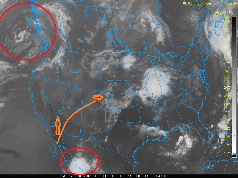
Infrared satellite image Sunday afternoon, August 9th.
The set-up mentioned above will bring in tropical moisture from Mexico on Monday.
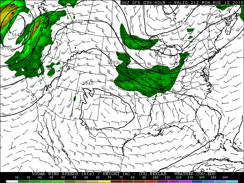
500 mb wind speed and geopotential height pattern for Monday, August 10th.
The moisture on Monday increases up to 1.2 inches of precipitable water, shown below. Moisture is also advected into Colorado from the east-southeast in the lower levels of the atmosphere. This southeasterly flow is linked to a weak cold front pushing south from Nebraska, moving through northeastern Colorado Monday morning. This is shown in the 850 mb GFS forecast plot, with the front outlined in blue. The blue arrows denote the northerly flow behind the front.
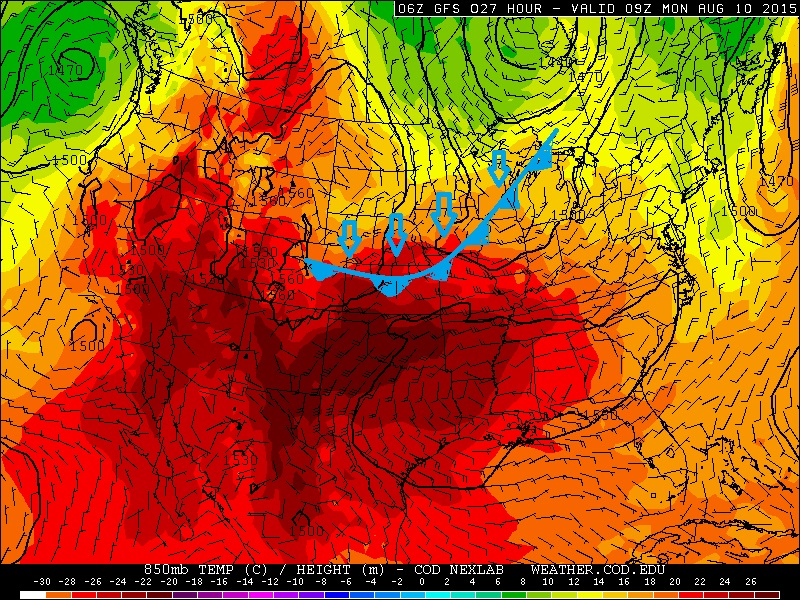
850 mb geopotential heights, temperature, and wind as forecasted by the GFS model for Monday morning
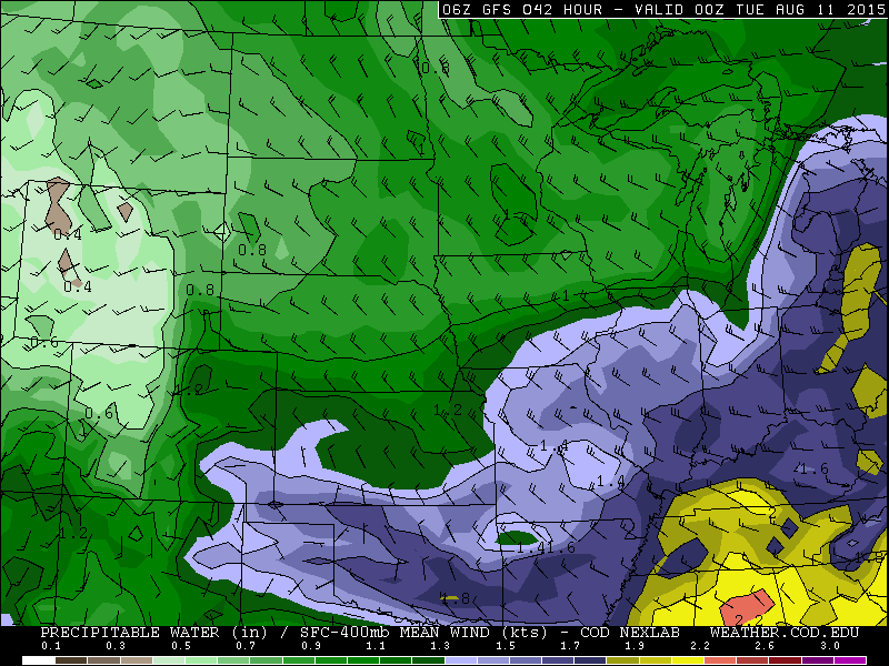
Precipitable water values for Monday as forecasted by the GFS model.
With the monsoonal flow and increased moisture, instability of 500-750 J/Kg of Convective Available Potential Energy (storm potential), as well as the low-level southeasterly flow over northeastern Colorado Monday from the cold front, temperatures will be cooler than Sunday in the lower 80’s with cloud cover and the increased storm activity. The upper level flow, as indicated in the 500 mb plot (three maps) above, is rather weak at 10-20 knots. This means any storms will be slow moving and could produce localized flash flooding and heavy rain in a short amount of time. The storms could linger into the overnight as an upper level shortwave pushes in from the southwest Monday night into Tuesday morning, as indicated in the below 500 mb vorticity plot from the GFS model. Forecasted precipitation amounts range from 0.5 to 1 inch through Monday night.
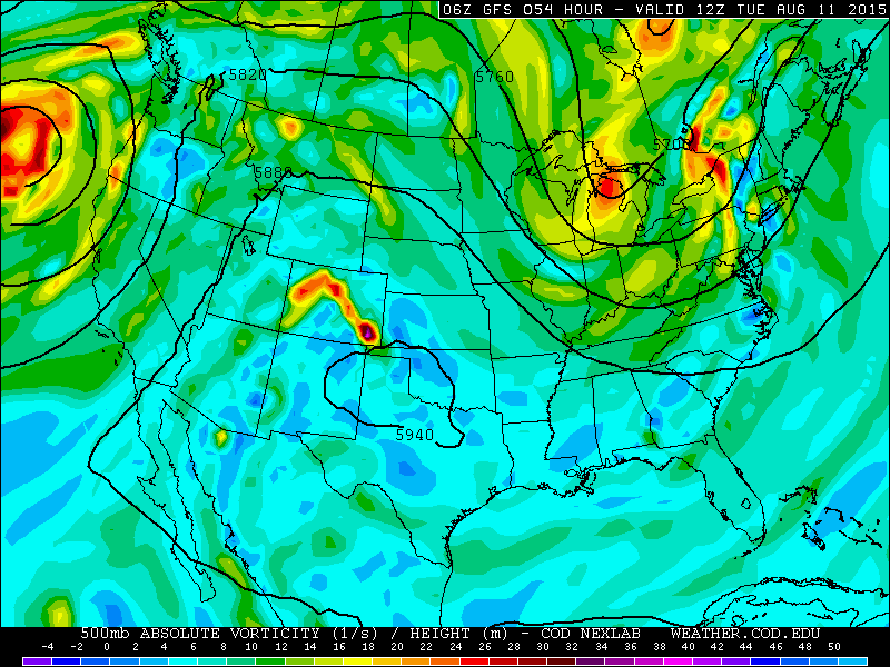
500 mb absolute vorticity for Tuesday as forecasted from the GFS model.
On Tuesday, a similar moisture, instability, and flow pattern will be present. Precipitable water increases to near 1.3 inches across Boulder County and instability approaches 750-1000 J/Kg.
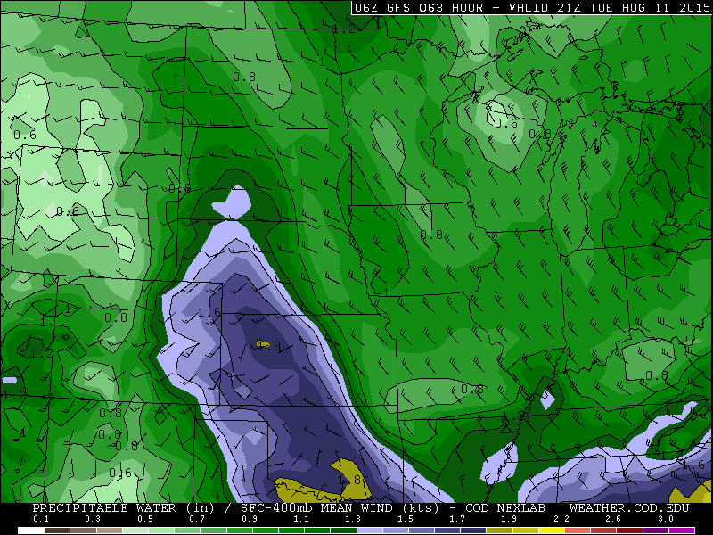
Precipitable water values for Tuesday as forecasted by the GFS model
The upper-level shortwave indicated above on Tuesday will also aid in lift for storms to develop in the afternoon and early evening. Temperatures will be very similar to Monday with the cloud cover and storm chances. At this point, it is unclear whether Tuesday will be wetter than Monday. The ECMWF model shows the most rain on Monday, while the GFS shows equal amounts Monday and Tuesday. The NAM model shows the best chance on Tuesday. In either case, it looks like Monday and Tuesday are our best chances for unsettled weather.
There is a slight indication that a few storms could become severe across far eastern Colorado Tuesday evening (figure below). The low-level flow is from the south-southeast, while the upper level flow is from the west. This coupled with instability above 1000 J/Kg in this region could produce some severe thunderstorms. This severe threat is non-existent over Boulder County, so we should be safe.
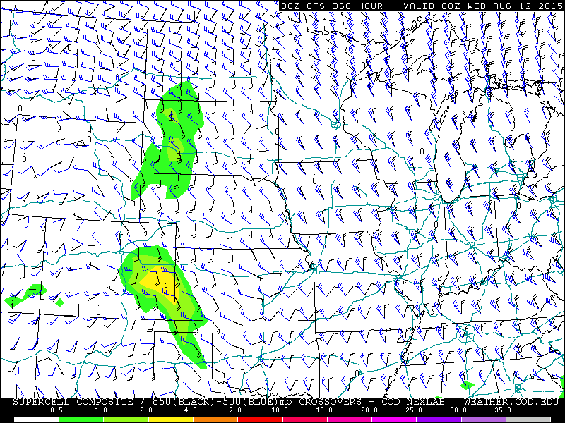
Severe potential for Tuesday evening as forecasted by the GFS model. The shaded areas denote severe potential based on wind shear and instability
On Wednesday, the upper-level flow shifts to a more west-northwesterly direction as the upper-level ridge that was over Texas Monday, moves westward into New Mexico and Colorado. This should lead to a lesser chance of storms as the ridge pushes the majority of the storm activity north and west of our region. Isolated afternoon storms will also develop with the daytime heating, but should be less widespread than Monday and Tuesday. Temperatures will also warm up with the reduced storm threat.
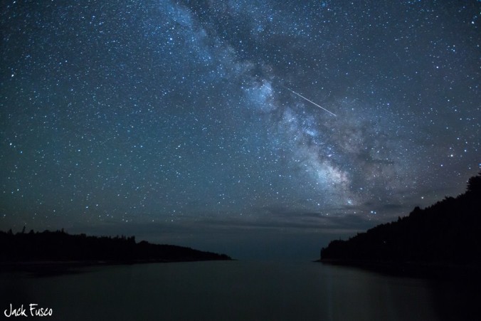
For the Perseid meteor shower, it looks like there will be cloud cover and isolated storms early in the evening. However, by late evening and overnight, clouds should decrease and give way to partly cloudy skies with a good chance of seeing the meteor shower. This year’s Perseid meteor shower is expected to be much better than the past few years as the Moon will be in its waning crescent phase, meaning that the brightness of the Moon will not interfere. The Perseids can produce as many as 50 to 100 meteors in an hour during the peak Wednesday night. The best chance to go out will be after midnight. You can find more information on the meteor shower here.
As we go into Thursday and Friday, the upper ridge continues to anchor itself across Colorado. The GFS and ECMWF are both consistent in the ridge pattern. This will keep any monsoon moisture at bay and lead to overall more sunshine and only slight chances for storms. This flow is indicated below at 500 mb. Also of note is that with the building upper ridge of high pressure, 700 mb temperatures increase up to 18 degrees Celsius, which will aid in warming up Boulder into the low 90’s to end the week.
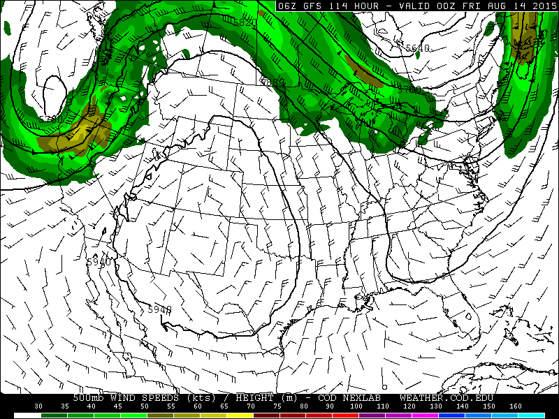
500 mb upper-level pattern for Thursday as forecasted by the GFS model
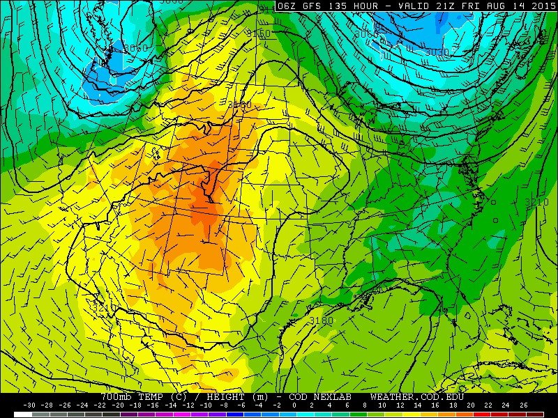
700 mb temperatures for Friday as forecasted by the GFS model. Temperatures reach as high as 18 Celsius Friday.
The Forecast for Boulder County:
Monday: Sunny skies becoming mostly cloudy with showers and thunderstorms first developing over the Mountains, then pushing eastward into the Plains by late afternoon and early evening. Highs in the upper 70’s in the Foothills and lower 80’s on the Plains. Storms in the evening could produce heavy rainfall and possibly localized flash flooding. Some isolated storms could linger after midnight.
Tuesday: A chance of an isolated shower or storm in the morning. Otherwise, mostly cloudy early, becoming partly sunny with afternoon scattered storms developing. Highs in the upper 70’s in the Foothills and lower 80’s on the Plains. Storms will linger in the early evening but taper off after sunset.
Wednesday: Mostly sunny with increasing clouds in the afternoon. Isolated storms in the mid to late afternoon into the early evening, but not as widespread as Monday or Tuesday. Best storm chances over the High Country. Highs in the low 80’s in the Foothills with upper 80’s on the Plains.
Thursday: Mostly sunny with partly cloudy afternoon skies and a slight chance of isolated afternoon/early evening storms. Warmer with high temperatures climbing into the mid 80’s in the Foothills and low 90’s on the Plains.
Friday: Sunny and hot with just a slight chance of an afternoon storm. Highs in the mid 80’s in the Foothills and low to mid 90’s on the Plains.
| Source | Mon | Tue | Wed | Thu | Fri |
|---|---|---|---|---|---|
| BoulderCAST | 83 | 84 | 90 | 92 | 94 |
| NWS | 83 | 83 | 87 | 87 | 90 |
| AccuWeather | 85 | 84 | 90 | 91 | 93 |
| The Weather Channel | 83 | 84 | 90 | 90 | 91 |
Last week’s recap:
Here are the results of last week’s forecast. First, the forecasts and observations:
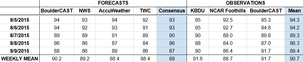
The consensus was for a hot start to the period under the continued influence an the upper-level ridge, with moisture moving in by Saturday (and a slightly better chance of rain), knocking temperatures back into the 80s for the weekend.
Now the error analysis. Shown is the amount of degrees (in Fahrenheit) that each source was off from the mean observed temperature for Boulder. Positive values indicate the forecast was warmer than what actually occurred, while negative values arise from a forecast that was cooler than what was observed.
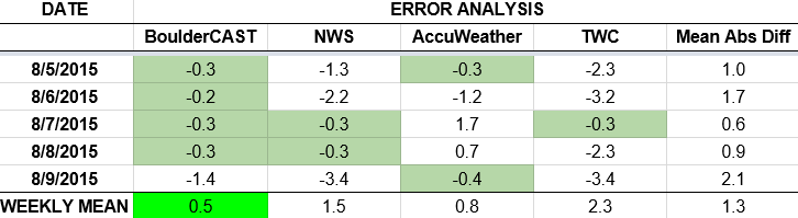
Wednesday and Thursday were indeed very warm, reaching into the mid 90s as expected. Running the numbers, BoulderCAST had the best forecast every day but Sunday, where we barely got bested. For the second consecutive week, we forecasted to within one degree on 4 out of the 5 days.
The bottom row of the error table shows the weekly mean error for each weather outlet, a good measure for who was the best and more consistent “forecaster” for the week. Not surprisingly, the best overall forecast for last week goes to BoulderCAST (two in a row!), just out-ranking AccuWeather with only 0.5 degrees of error averaged across the week. That value is going to be hard to beat moving forward. Check back next week to see if BoulderCAST takes first place for third consecutive week.
—
If you haven’t already done so, follow us on Twitter or Facebook for frequent weather updates and subscribe to the site to get these posts automatically delivered to your email box (enter your email in the sidebar widget to right).


You must be logged in to post a comment.