
The March sun has already made its presence known, quickly working to wither away yesterday’s dumping of snow. We review the storm totals from across the region, and reveal when we’ll return to those spring-like 70’s (spoiler: it’s shockingly soon). We’re also already tracking our next potential snow event. Read on for details.
After 34 hours of essentially continuous snowfall in Boulder, flakes finally came to a close last night around 7:00pm, when drier air moved in from the north.
Boulder officially recorded 15.0″ of snow, with 10.5″ of that falling on March 18th. This would have been a record, but unfortunately this event aligned precisely on the 18-year anniversary of the March 1998 super El Niño snowstorm. Therefore, it came up about six inches short. At BoulderCAST, we only measured 14.2″.
To the east, Denver scratched a much smaller number into the books, with a storm total of only 4.7″ (at DIA). It’s times like these that shine a big, bright spotlight on the influence of Boulder’s topography for snow and demonstrate why Boulder’s annual snowfall is nearly twice that of Denver! Our seasonal snow total is now 70.0″ in Boulder (43.2″ in Denver). The normal end of March snow total is 71″ (46″ in Denver), so we’re now right back on track.
And would you believe the best powder in the entire country over the last 72 hours is just a stone’s throw from Boulder. That’s right….Eldora!

Our spring snow outlook is looking all the better right about now!
We’re okay with the outcome
Shown below is our original forecast snow map (issued Thursday morning), with the observed storm totals per location contained in boxes. Green ones indicate that the observed snowfall was within one inch of the given forecast range, while red was outside the scope of our forecast.
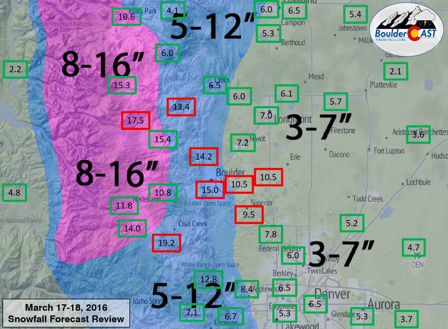
Despite the National Weather Service sticking to their 3-6″ forecast for all of the Plains, we were confident that the west and northwest suburbs had the potential for higher snow amounts, so we went with 5-12″ in those locations. We outlined a swath in the northern Foothills with 8-16″ where we believed the best lift and upslope would be. Everywhere else we went with 3-7″.
There was a large range in snow totals, from 2″ well east of Longmont, to 19″ in the Foothills southwest of Boulder. Overall our forecast was great for the region. Lot’s of green across the board! Ironically, though, our only bust was actually in the immediate Boulder area. Higher snow amounts, up to 10″, extended a bit further east into Superior and Louisville, while the city of Boulder itself outperformed even the most bullish of model snow forecasts. In retrospect, there is nothing we could have done differently to expect 15″ in Boulder! It was un-forecastable (is that a word?).
A bulk of our forecast was spot on, including:
- Heaviest snow would be overnight Thursday into early Friday morning
- Heavy snow bands oriented WNW to ESE would be possible with the jet overhead
- Persistent but weak upslope
- Snow lingering into Friday evening
Right on cue, the overhead jet stream delivered a few big bands to the Denver Metro area Thursday night, like the one below from 7:00pm Thursday.
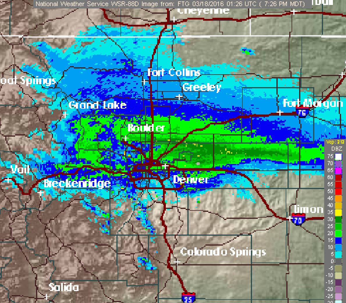
Admittedly, the jet didn’t have that big of an influence in Boulder, at least as far as the percentage of snow directly attributable to it (we’d say that’s about 25%). The biggest contributors were persistent weak upslope combined with a decent amount of vertical instability. We also managed to get some great dendritic snow growth (big fluffy flakes!) towards the end of the event (which was expected). Denver, on the other hand, can probably attribute closer to 50% its snow to jet-forced banding.
Interestingly, this storm produced only a couple of inches less in Boulder compared to the Groundhog Day storm in early February, which, if you recall, had significantly more hype!
So what happened?
All along the models had the heaviest snow remaining north of us, from Fort Collins into Cheyenne, especially in their adjacent Foothills. Based on observations, those areas got skunked, particularly in SE Wyoming. Cheyenne was under a Winter Storm Warning for 5-10″, with some favored spots expecting up to 15″. Not a single storm total exceeded 4″ on the Plains there. A similar thing happened in Fort Collins, but they were at least able to squeeze out 4 to 8″.
So yes, something did happen. The very small feature responsible for the storm tracked just slightly further west and south. We cautioned in our forecast Wednesday that these type of systems, which scream southward with a saddle on the jet, are not easy to predict. The models have an extremely tough time with them.
The biggest red flag for us was waking up Thursday morning to find that a cold front had pushed through the region and snow was already falling across the Metro area. That front can be seen below, moving through Boulder just before 5:30am.
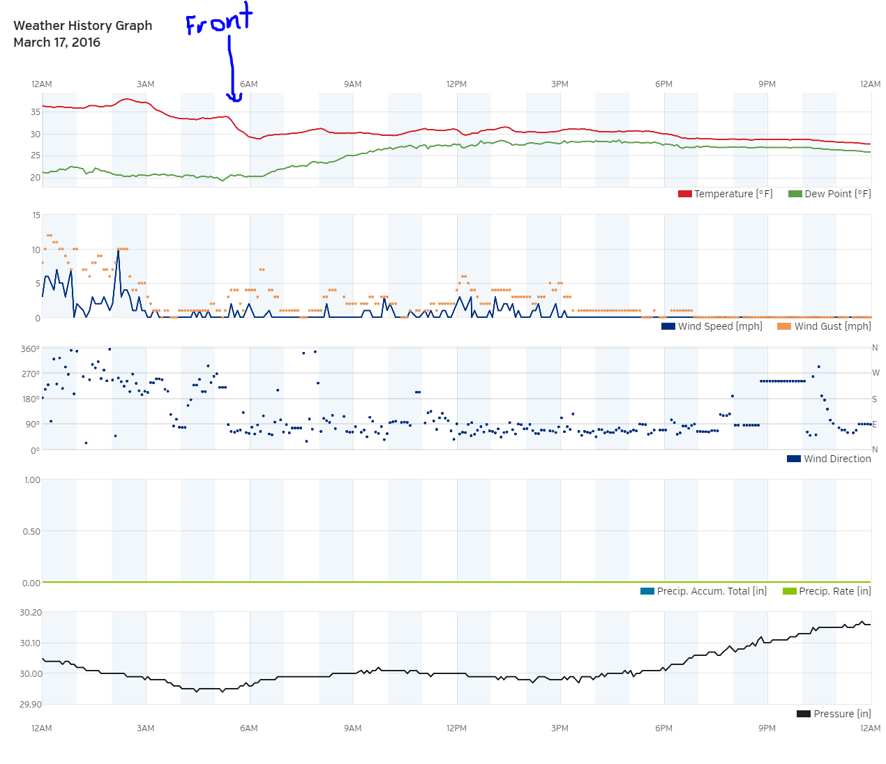
The northeasterly wind shift was not in the forecast until later Thursday, say around 5:00pm. The “ninja” front is seen below to our south in NCEP’s surface analysis for noon Thursday. The front that ultimately brought the frigid air and more significant upslope at this time was only entering northeast Wyoming (seen below).
 Before the real front even arrived, Boulder had already picked up 2.5″. The added cloud cover during the day Thursday and cooler air mass ultimately allowed for less melting of snow at the onset and completely eliminated the chance of any rain mixing in. This pre-liminary front was no doubt related to the models’ struggle to resolve the storm. These type of systems are not all that common, and even more infrequently result in major snow events. We can only hope the models do a better job next time. But hey, is anyone actually complaining about another snowstorm exceeding expectations?
Looking ahead to warmer times
Would you believe us if we said to expect more than a foot of snow, then two days later to get your shorts out for 70’s? Of course you would. This is Colorado!
After a chilly Saturday with some lingering cold air, the first day of Spring (tomorrow) will climb twenty degrees into the low 50’s for an afternoon high. With a further twenty degrees of warming, we’re back in the low 70’s Monday afternoon! At least that’s what the models are currently showing. We’re a little skeptical with the amount of moisture on the ground if 70 will be obtainable. 60’s for sure, though.
Don’t get your heart set on spring cleaning and planting flowers just yet. We’re already hard at work tracking our next potential snow storm late Wednesday into Thursday this week. It looks very promising for someone, but we’ll reserve further discussion on that for Monday’s weekly post. The end of March could definitely continue to be interesting. Enjoy the sunshine and melting snow. There is already some bare grass out there!
If you haven’t already done so, please consider taking our short survey. We’ll be shutting that down Monday. Find the link below.


You must be logged in to post a comment.