From summer to winter in the blink of an eye! There has been quite the weather transition in the last 48 hours. We review yesterday’s snowfall and give some insight into when we may see our next.
Storm Recap: Today it is summer winter!
We reached the apex of the temperature roller-coaster ride on Wednesday afternoon as Boulder soared to 85 degrees, shattering the existing record value of 80 for the date. From there, temperatures declined steadily, dropping 53 degrees over the next 26 hours into Thursday evening. A quick-moving storm brought a brief period of upslope and moisture to the region, producing rain showers that mixed with and changed to snow Thursday afternoon and evening.
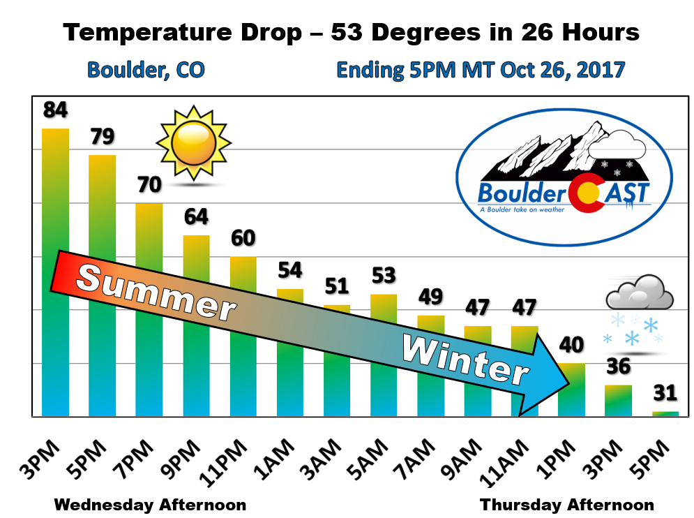
This type of extreme weather shift is a rarity, even for the Front Range. In fact, transitioning from the mid 80’s on one calendar day to snowfall on the next may only be possible in the United States in the lee of the Rocky Mountains….in such places like Denver, Cheyenne, and Pueblo. The key factor here is the added heat from downslope (compressional) warming. Without it, an 85 degree airmass would be very unlikely to exist so close by to one capable of supporting snow the very next day. 60’s and 70’s one day with snow the next are somewhat common, but 80’s to snow is extraordinary.
As expected, despite a few moderate to heavy bands of snowfall, the warm ground temperatures from the record heat limited accumulation in most locations to just a dusting on grassy surfaces. Shown below is our original forecast snow total map from Wednesday morning, with the observed storm totals per location contained in boxes. Green boxes indicate that the observed snowfall was within one inch of the given forecast range.
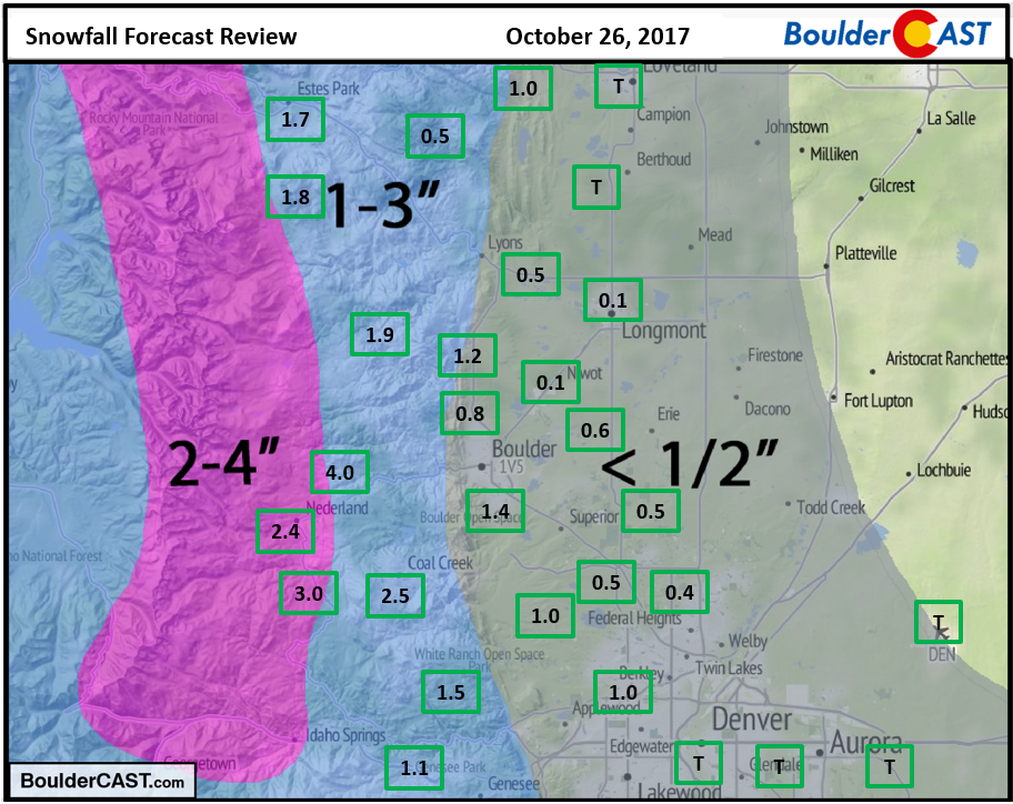
A good, though admittedly simple forecast all-around. The official total was 1.6″ in Boulder, with just a trace recorded (two flakes?) in Denver (DIA). The highest amount reported was 4.0″ in the Foothills west of Boulder. Even on an elevated snowboard, we question Boulder’s official measurement (seems a little high). Nonetheless, the event was more shocking than it was impactful for everyone on Thursday. Roads remained just wet and the evening rush hour was akin to any other day, despite the falling snow. We may not be as lucky for our next storm…
Another round of snow on Monday?!
We’re already tracking our next potential snow event for the region, with the latest round of weather models zeroing in on Monday or Monday night. There are a lot of moving parts going into this next storm, so confidence is rather low right now. Particularly, a cut-off southern track system is set to merge with a colder northern track storm somewhere across Colorado. The timing needs to be just right. Otherwise, we end up with two wimpy events, one of which could be too warm for snow altogether.
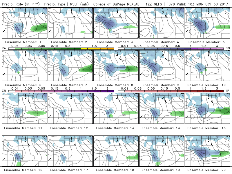
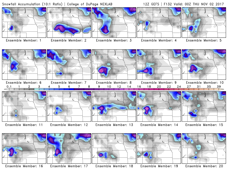
To help better explain the uncertainty, let’s look at the latest round of GFS ensemble model runs. Firstly, though, we remind you that ensemble runs are from the same exact forecast model, but with slightly different initial states. To run a model, you must feed it the current conditions of the atmosphere…ALL of the atmosphere. And since we don’t have observations of the weather at every single location and at all altitudes, much of the initial input is also “modeled” itself. This can create errors and uncertainty, and one way to gauge this is to change the initial state slightly and re-run the model. The output runs are called “members”. The GFS ensemble has 20 members and each tiny image below is output from one of them…..
We’ll keep things “simple” and focus only on the resulting potential for snowfall. The timing of the model output below is Monday at 12:00 PM. I know they are small….click to enlarge if needed.
Here is what we see:
- Member #3, 5, 8, 9, 10, 15, 20 (35%): A fairly significant snow storm for northeast Colorado. These runs depict 4 to 10″ for Boulder.
- Member #2, 4, 12, 13, 16, 17, 18 (35%): These runs develop little to no snow across northeast Colorado, and in some cases, form a powerful storm across southern Colorado.
- Member #1, 6, 7, 11, 14, 19 (30%): These runs are in the middle ground, bringing a quick-moving but moderately strong storm to much of Colorado. These runs produce 1-4″ of snow in Boulder.
Here is the resulting snow totals from each member…
And now the snowfall plume forecasts from the “pixel” containing Denver International Airport. The mean is about 2″ of snow, but there are some snowier members. Also note that Boulder typically doubles (or triples) up Denver in these type of snow scenarios.
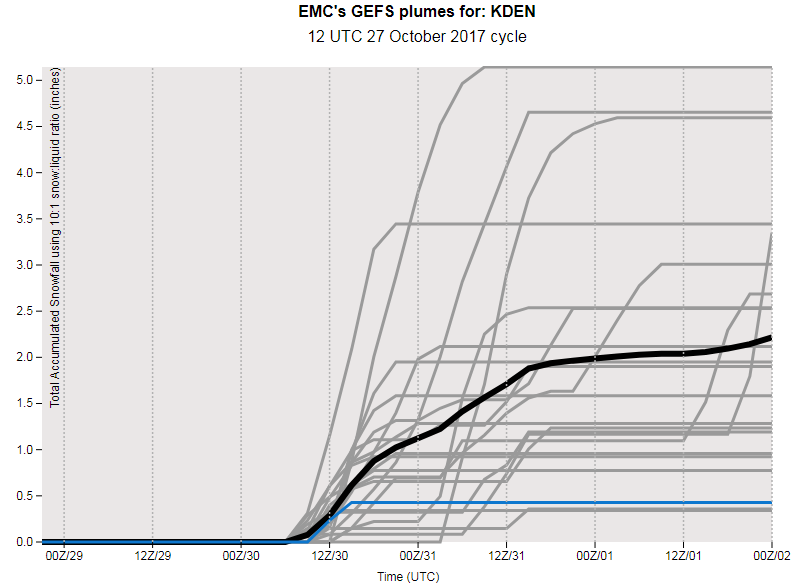
And remember, this is just the 20 ensemble members from a single model, the American GFS. There are 52 in the European model and 20 from the Canadian which we aren’t discussing here! The Euro has a vastly different outlook for Monday than the GFS, and much less snowfall in general. There is even the possibility of some freezing drizzle based on some of the model sounding. Four days out, there is an uncomfortable amount of uncertainty in this one. Our feeling right now is that this system will materialize too far south and bring snow mostly to the southern portion of the state. This of course doesn’t mean no snow for our region, but it probably won’t be too much to worry about. Time will tell. Look for updates later in the weekend from our team, if necessary.
Become a Premium member to get daily updates to this forecast, and peek ahead to the powder coming to the ski resorts. Join now and save 30% through the end of October with coupon code SNOW.

Share this post:
.


You must be logged in to post a comment.