
The main story for the week ahead will be the roller-coaster ride of temperatures! They will soar to near 80 degrees by midweek, but then tumble to bring the chance of snow to the region by Thursday. Read on for our complete outlook of the upcoming week.
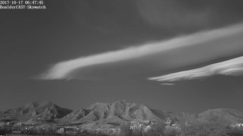
Powerful winds aloft have made for stunning wave clouds and standing lenticular displays across the region of late. Here is the “UFO Cloud” seen west of Boulder last Tuesday morning just before sunrise (October 17).
And how about last night’s sunset… Not bad, eh?

Photo credit: Reddit user capital-gain.
Spotty wave clouds will continue today, but should subside as we progress into Tuesday and the rest of the week…
Northwest flow
Strong flow aloft will veer from northwesterly to northerly during the first half of the week. This flow would ordinarily be great news for skiers if it had even a hint of Pacific moisture. However, a distinct lack of low and mid-level moisture in this flow will lead to dry conditions statewide through Wednesday night.
You will notice the flow direction across Colorado make this change in the 500 mb maps below for Monday (left) and Tuesday (right). Also note the deepening trough across the eastern United States. This trough is bringing the coldest air of the year and the season’s first snow to some locations across the Great Lakes.

GFS 500 mb vorticity map for Monday (left) and Tuesday(right). The flow across Colorado is denoted with the red arrows.
Northeast Colorado will catch some fringe effects for this trough, mainly a few dry cold frontal passages. The first wave arrives this morning, with another slightly cooler push tonight. This will keep high temperatures below normal today and Tuesday…
Can you find Monday morning’s cold front?
The 800 mb temperature map below shows the cold front pushing very far south…well into the Gulf of Mexico, by Tuesday morning. We’re almost into November at this point (yikes!), so this really isn’t all that surprising…
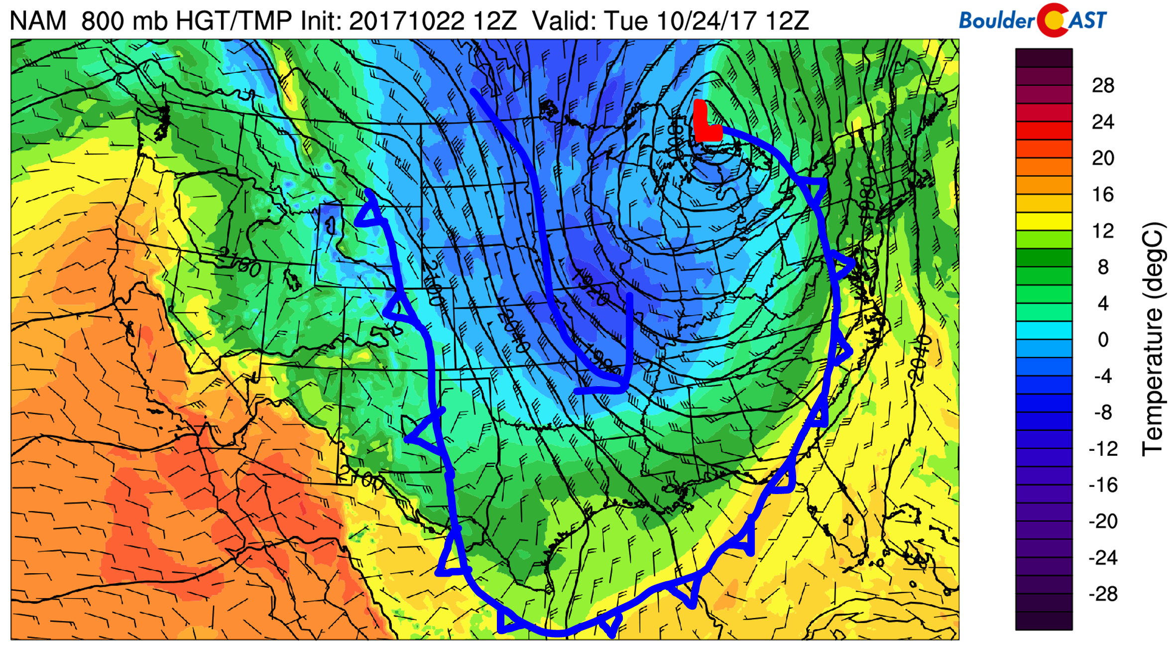
NAM model 800 mb temperature and wind map for Tuesday morning showing the position of the cold front
Wednesday: Warm & breezy
By mid-week, we’ll see our temperatures jump significantly thanks to downslope warming. We wouldn’t be surprised if the lower elevations approach the 80-degree mark on Wednesday. Low relative humidities and breezy conditions could produce high fire danger for the Front Range Wednesday afternoon. It’s unclear to me exactly how gusty it may be at this time, as the fastest winds may stay just north of the Boulder area. Nonetheless, use caution regardless if the Red Flag Warnings are posted or not.

Late week snowflakes?
In the map above, we also noted a weak system embedded in the northwest flow, which on Wednesday, will still be located in Canada. This storm has piqued our interest for many days now, but models remain very inconsistent on the impacts it may have on the Front Range.
We know Thursday and Friday will be SIGNIFICANTLY colder than Wednesday, but the potential for rain and snow across Colorado remains uncertain. It’s a quick hitting storm, only looking to bring a brief shot of semi-moist upslope to northern Colorado Thursday afternoon and evening. It doesn’t have much upper-level support either. It could even be moving too fast for the rain to ever change to snow across the lower elevations before the storm is over.
We can’t give a definitive forecast at this time. Some model runs are showing just isolated light rain/snow showers for the region, where others portray the storm as a 1-2″ snow event for the western Metro Area, including Boulder.
We’ll provide updates later in the week if this storm demands it. Right now, our gut feeling is that this one will be mostly a no-show. Nonetheless, temperatures will tumble 40 degrees for Thursday with highs remaining in the 40’s!
Afterwards, cool but sunny weather will take over through the upcoming weekend. Great for trick-or-treating, or other spooky October activities. Have a great week!
Forecast Specifics:
Monday: Mostly cloudy, cool, and breezy. Highs will be in the low 50’s for the Plains and low 40’s in the Foothills.
Tuesday: Mostly sunny and cool. Highs in the low 60’s on the Plains and low 50’s in the Foothills.
Wednesday: Nothing but sunshine, very warm, and breezy. Expect high temperatures in the upper 70’s on the Plains and middle 60’s in the Foothills.
Thursday: Maybe some morning sun, but otherwise overcast skies during most of the day. Light rain and snow showers will be possible during the afternoon and evening. Little to no snow accumulation expected at this time, except maybe an inch or two in the Foothills of Boulder County. Temperatures will hinge on the timing of the cold front, but we expect 40’s for the Plains with 30’s in the Foothills, falling further during the afternoon. Winds will be breezy out of the north-northeast.
Friday: Partly sunny and chilly with highs in the low 50’s for the Plains and the low 40’s in the Foothills.
Weekend: The upcoming weekend looks very quiet across the state of Colorado. Temperatures will slowly be moderating back towards seasonal values with lots of sunshine. Expect 50’s Saturday and 60’s on Sunday.
High Country: The mountains will see generally good conditions through most of the week. Strong northwest flow on Monday will make for blustery conditions on Monday for the northern part of the state above treeline. Winds relax for the rest of the week, with a chance of light snow accumulations for the eastern slope of the Front Range Mountains Thursday. 1-2″ is about all though. Find the latest forecast for all your favorite Colorado ski resorts on our PowderCAST page.
DISCLAIMER: This weekly outlook forecast is was created Monday morning and covers the entire upcoming work-week. Accuracy will decrease as the week progresses as this post is NOT updated. To receive daily updated forecasts, subscribe to BoulderCAST Premium.

Share our forecast:
Mon
Tue
Wed
Thu
Fri


Temperature
52
61
78
45
50


Precip Chc (Plains)
0%
0%
0%
20%
0%


You must be logged in to post a comment.