
We discuss the forecast for more snow Saturday night across the Front Range, and detail the locations that will see a White Christmas!
Update (Sat 12/23/17 at 3:00 PM):
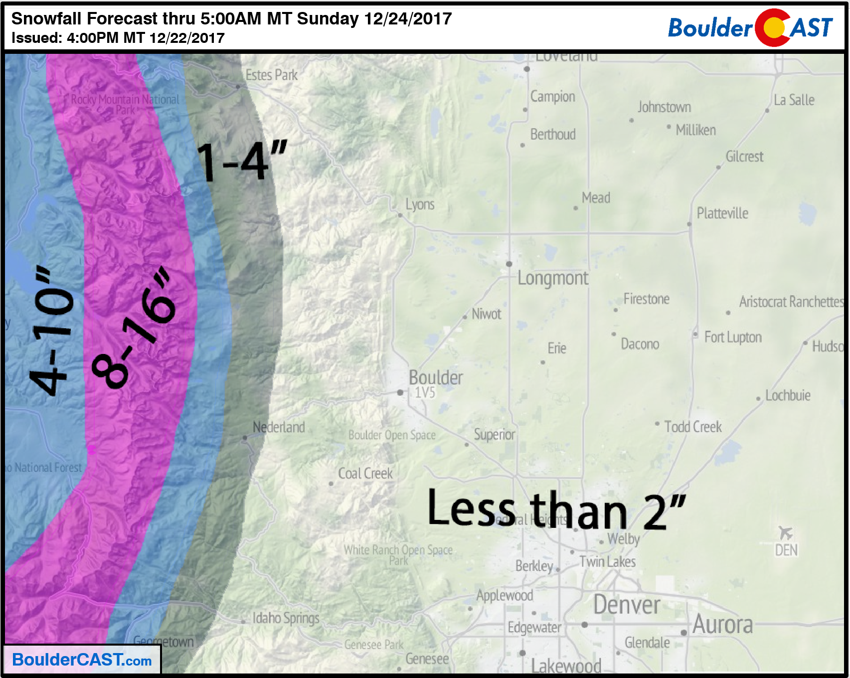
No changes needed to our forecast from last night. High-resolution models are showing the jet-forced heavy bands of snow we mentioned. The current timing to impact Boulder/Denver is from 6PM to 10PM. Everyone should see at least a dusting of snow up to 3″. A few isolated areas could see 4 or 5″ if a heavy band lingers overhead.
Snowfall rates in these bands may approach 2″ per hour producing rapid accumulation and difficult driving with low visibility. Keep that in mind if you are traveling this evening…
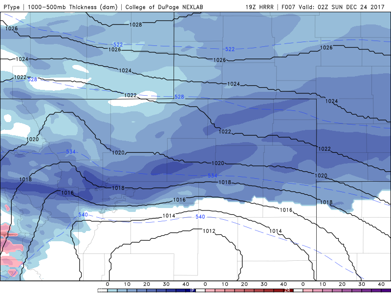
Latest HRRR run showing a very heavy band of snow impacting the north Metro area between 6PM and 8PM.
Winter Solstice snow recap
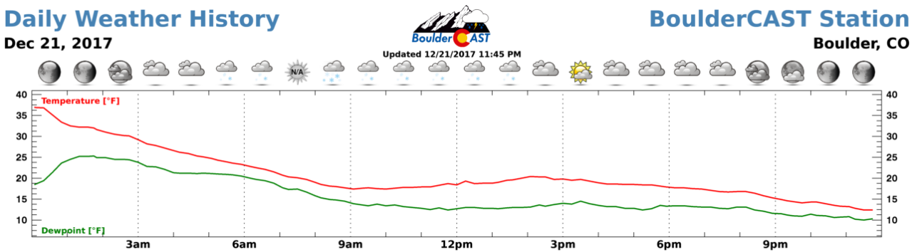
Right on cue, the Winter Solstice delivered light snow and frigid temperatures to the region yesterday. The weather history graph below from BoulderCAST Station shows the light snow began near 5:00 AM and ended around 2:00 PM. The high temperature of 37 degrees occurred as the clock struck midnight, with temperatures falling all the way to 12 degrees at 11:59 PM.
Our final forecast called for generally 1-4″ across the region, compliments of upslope forcing and fluffy snow ratios. The official total in Boulder was 3.0″ (which contained 0.18″ of liquid, equating to a snow ratio of 17:1). DIA reported just 0.7″.
Shown below is our original forecast map issued Wednesday morning. The observed storm totals per location are contained in boxes. Green ones indicate that the observed snowfall was within one inch of the given forecast range, while red was outside the scope of our forecast. No red in this forecast.

White Christmas Defined
Remember there are two acceptable meteorological definitions for the occurrence of a “White Christmas.”
- 1″ of snow present on the ground at any point during Christmas Day (this is the “official” definition as denoted by the NCDC).
- At least 0.1″ of snow must fall and accumulate on Christmas Day.
Surely we all prefer the second option, with actual snow flying as you open your gifts and stuff your face with food. Old, disgusting brown snow on the ground doesn’t really tend to spread the holiday cheer, now does it?
In a past podcast, we discussed Boulder’s “White Christmas” climatology. When just considering the last 17 years, Boulder has a 35% chance of recording snowfall on Christmas day, but a 59% chance of having some snow on the ground. The longer term averages for Denver (14% snowfall and 38% snow on ground) suggest we have been relatively more fortunate since the turn of the century!
The climatology map below paints the Front Range above 40%, with near 100% odds in the western Mountains.
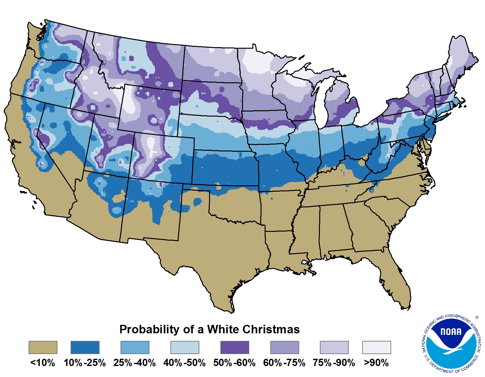
Percentage chance of having snowfall occur on Christmas (Credit: NOAA). This is a climatology, not the forecast or specific odds for 2017.
2017 White Christmas forecast
The models of late have been struggling with how to handle the very cold air located across central Canada. Earlier in the week, they were showing one of the coldest air masses in a few years coming to Colorado. It truly looked as though a deep freeze would take hold across the Front Range with a near guarantee of meeting the “1 inch of snow on the ground” criteria for a White Christmas. However, things have changed with the colder air now projected to remain largely to our north and east across the Great Plains.
Below is GFS surface temperature forecast for Saturday night from a model initialized this past Tuesday evening. Take particular note of the cold air across Colorado (generally -10 to +10 degrees for the Front Range).

The models have pulled away from this solution and it looks as though this weekend won’t be too cold at all. Below is the latest forecast from the GFS for the same Saturday night timeframe. We have highlighted the coldest air in yellow, along with two black tracks. Typically, the general weather pattern will push the Arctic air along Track #2, mostly sparing eastern Colorado. However, on some occasions, the atmospheric set-up can allow the coldest air to push into our region (Track #1).
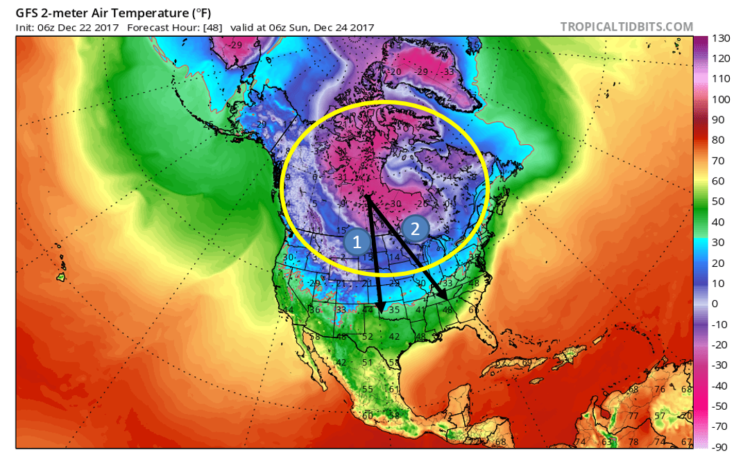
One big factor for this track is actually what’s happening in Alaska. If there is a dominant ridge across central and southern Alaska, cold air can find it’s way into Colorado (but usually not much snowfall). This weekend however, the ridging in Alaska, while strong, is centered too far north and east. The resulting flow into the continental United States doesn’t have the necessary southward push into Colorado. The resulting flow will confine the cold air to the northern Great Plains for Christmas.
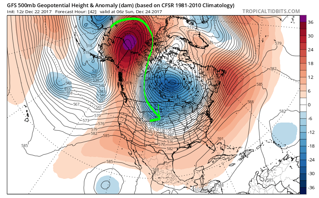
500 mb height anomaly for Saturday night for North America. The flow directs to coldest air into the Northern Great Plains (green line) and not Colorado.
Enough about what could have happened this weekend… Let’s discuss the actual snow potential for Saturday.
Despite the super cold air not making an appearance for Christmas, a weak disturbance embedded in the northwest flow will slide across southern Wyoming Saturday evening (see below on left). This system will generally downslope northern Colorado and therefore is not likely to produce much snowfall east of the Continental Divide. However, one tricky part of the forecast is the presence a 150 mph jet streak. Models are showing the potential for banded snowfall from Boulder northward into Cheyenne Saturday evening. We will briefly be in the left-exit region of the jet (see below on right), with perhaps decent mid-level moisture overlapping the forcing for a few hours.

While the components of the storm will be in their dying stages across Colorado, jet-forced snow bands could blanket parts of the Metro area with fresh snow after sunset Saturday. The keyword here is PARTS. The bands will be spotty if they do materialize. The most likely time-frame will be from 5PM to midnight Saturday night. With snowfall rates of 1″ per hour or more, even brief snowfall could amount to some accumulation under one of these bands. In general, though, most areas will see either no snow or just a dusting this time around.

High-resolution NAM simulated radar (with precip type) for Saturday evening’s snow
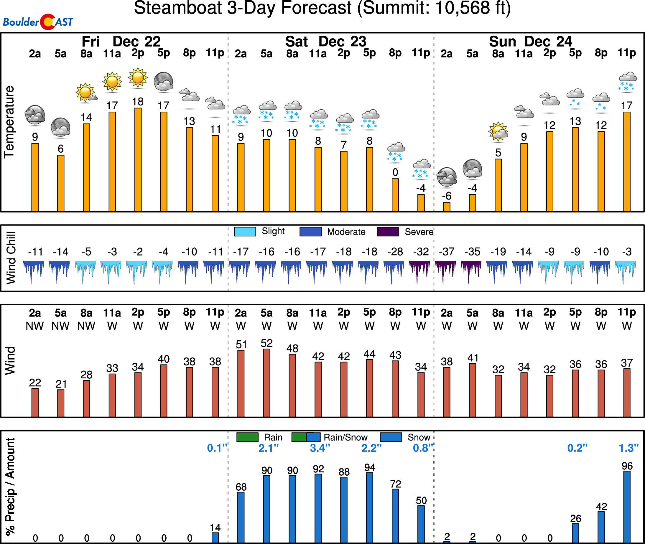
Another big story for this weekend will be heavy snow in the Mountains, especially those favored by northwest flow. Copious moisture will be present in the mid-levels of the atmosphere from late Friday night into late Saturday night. This 24-hour window will see moderate to heavy orographic snows on west-facing slopes. We’re talking one to two feet for areas north of Interstate 70 and above treeline. Most of the ski resorts will see 4 to 10″ of snow this weekend, with favored spots like Steamboat likely to exceed a foot. A secondary storm is on-tap to bring lighter accumulations to the Mountains for Christmas morning, too. Hooray!
Check the forecast for all of Colorado’s 22 ski resorts over at our PowderCAST page.
So here is how the forecast will play out through Christmas…
Saturday: A benign day across the Metro area with high temperatures in the lower 40’s under a mix of clouds and sun. Spill-over snow from the Continental Divide could produce a few inches of snow above 8,500 feet along Peak to Peak Highway. Heavy mountain snow will fall in areas near and above treeline, 8-14″ worth! A cold front arrives in the evening, with isolated banded snowfall possible after sunset. Little accumulation is expected, except in the areas impacted by these bands where up to 2″ may be possible.
Christmas Eve: Partly cloudy and cool with highs in the low to middle 30’s. With temperatures remaining cool, snow on the ground will be slower to melt. Light accumulations will be possible for the Mountains late Sunday night into early Monday. Just in time for Santa!
Christmas Day: Partly cloudy and chilly with highs in the mid to upper 30’s. There is some potential for a few flurries Monday evening for the Metro area, but no accumulation is expected at this time.
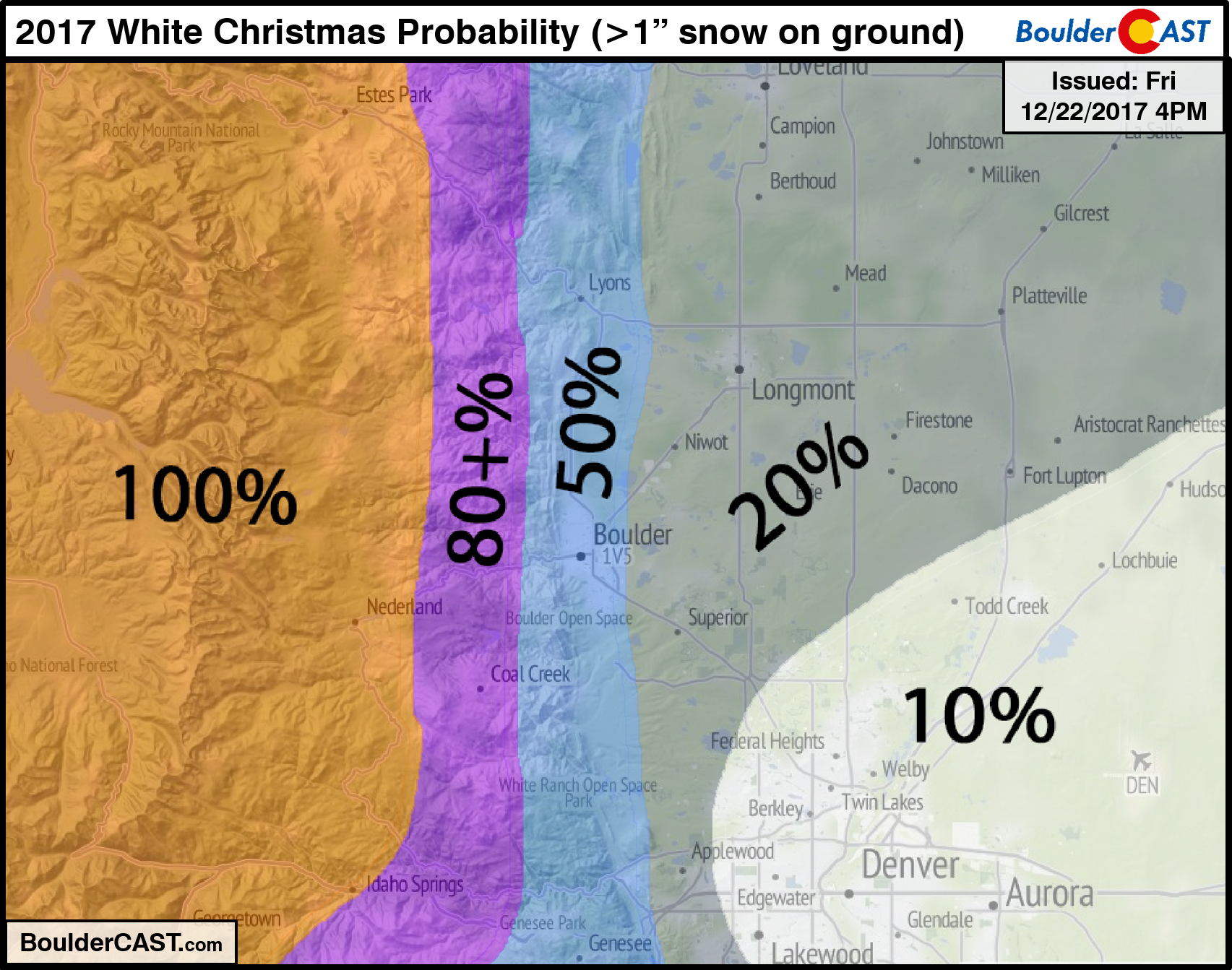
Below is our forecast map for the probability of a White Christmas, that is “at least 1 inch of snow on the ground”. We do NOT believe the Metro area will see any accumulation on Christmas Day at this time. The Mountains (west of the Divide) should see some fresh snow come Christmas morning.
That’s all for now. We’ll pass along any updates if needed for Saturday’s snow.
Subscribe to receive email notifications for BoulderCAST updates:
We respect your privacy. You can unsubscribe at any time.
From all of the BoulderCAST Team,
we wish you Happy Holidays!
.
Share this forecast:
.


You must be logged in to post a comment.