
We wish there was better news, but the atmospheric pattern remains largely unchanged for the upcoming week. Thus, a chilly and unsettled stretch lies ahead. Read on for our complete forecast, which does include exactly ONE nice day.
Rain/snow linger for Tuesday & Wednesday (& Thursday…)
We haven’t been at 60 degrees in Boulder since last Friday afternoon, and we may not reach that mark at all this week. A persistent broad trough of low pressure will remain entrenched across the western United States through the week. Under this pattern, cool and unsettled weather will be the norm.
The 500 mb vorticity map below is for Tuesday afternoon, and shows a busy set-up for Colorado to say the least. The same slow-mover which brought rain and snow to the region yesterday still has not fully progressed across the state. This will actually happen during the late afternoon and evening hours today. Also notice a secondary storm system gearing-up across Idaho. This one will be impacting the Front Range on Wednesday.

GFS 500 mb vorticity map for Tuesday
The focus for energy with Tuesday’s trough is already well south and east of the Front Range. It’s there that a potent surface low will be impacting far eastern Colorado, Kansas, and Nebraska. There is a little bit of cold air available, enough to produce a few wet inches of snow on the northwest flank of the storm. Most of this will not be able to reach far enough westward to impact the Metro area directly. However, it will help to keep the shallow upslope going and clouds socked-in.

NAM precipitation type forecast for Tuesday evening
For Tuesday, our region will be cool and gloomy. Low clouds, fog, and drizzle in the morning will give way to a few isolated afternoon rain/snow showers compliments of the lingering moisture and minimal solar heating expected across the higher elevations. No accumulation is anticipated, except in the Mountains where a quick inch could fall. Highs will be chilly in the upper 30’s.
On Wednesday, the secondary system will move in bringing yet another chance of rain and snow showers to the state. The main forcing on this day will be a 110 MPH jet streak passing over us with a favorable orientation. This particular disturbance will be quick-moving and far less organized than the one earlier in the week. Nonetheless, the jet dynamics should hit the Front Range head-on.
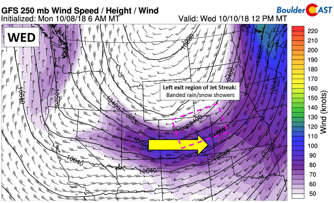
GFS 250 mb wind forecast for Wednesday afternoon. The Front Range will be in the left exit region of the jet.
We’ll be in the left exit region for about six to twelve hours or so, which will lead to isolated to scattered banded precipitation across northern Colorado. Expect these to commence during the overnight hours across western Colorado, making it to the Front Range by morning and persisting through the evening. Given the potential intensity of these bands, some burst of snow may occur on the Plains as well. Furthermore, across the Mountains, some CAPE is indicated which may lead to very heavy snowfall rates and isolated lightning in the more organized bands. Impact should be minimal, but don’t be surprised by a few flakes flying during the day Wednesday.

NAM CAPE forecast for Wednesday afternoon. Instability could lead to a few thunderstorms
Highs Wednesday remain nearly 30 degrees below normal in the upper 30’s.
Uncertainty elevated late in week with track of Sergio’s remnants
A complicated pattern is expected to develop towards the end of the week. The persistent trough that has plagued the western United States is projected to elongate and form a cut-off low pressure system across California (see below). At the same time, Hurricane Sergio (likely a tropical storm by then) will be making landfall in Baja California with a ticket to enter the southwestern United States, not unlike Tropical Storm Rosa did two weeks ago.
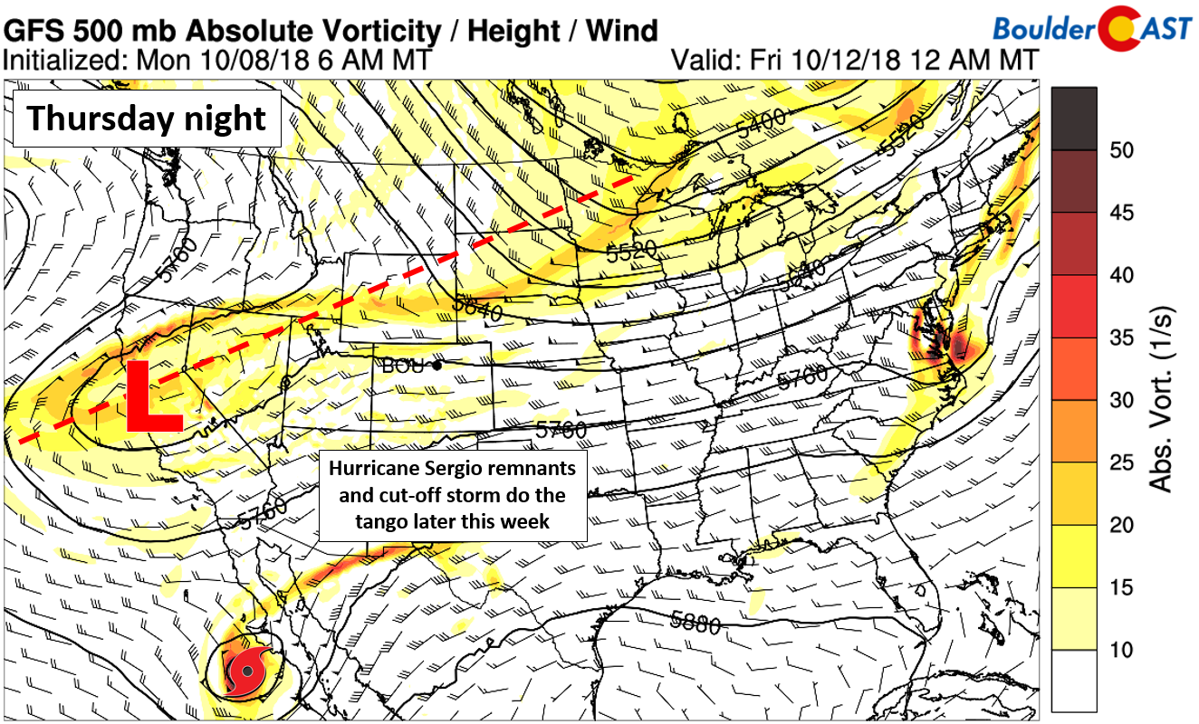
GFS 500 mb vorticity map for Thursday night. Tropical Storm Sergio will be interacting with an elongating trough across the West.
The latest forecast track from the National Hurricane Center brings Sergio into New Mexico or west Texas Friday night (see below). However, we can hardly trust this forecast cone five days out with the steering controlled mainly by a developing cut-off low (which itself is fairly uncertain right now).

If that track above for Sergio does verify, the tropical moisture pool will remain further south and not get entrained into the large-scale trough impacting Colorado. It does seem that the GFS and European ensembles are bending towards this southern track as well. Thus we will not count on this moisture playing into our forecast at this time.

GFS precipitable water forecast for Saturday morning. The remnants of Sergio are projected to stay well south of our region.
Nonetheless, with the trough elongating towards the weekend across Colorado, the unsettled pattern will remain, particularly on Thursday. Expect another round of isolated showers (rain on Plains, snow higher up) with temperatures MAYBE getting near 50 degrees.

GFS precipitation forecast for Thursday evening (left) and Friday evening (right)
Friday is primed to be the nicest day of the week. While still cooler, we should see some sunshine with afternoon temperatures nearing 60 degrees. Way to go Mother Nature…ending on a strong note!
For Saturday, we are already watching another storm system embedded in the northwest flow. For me, this one is the most intriguing in regards to snow potential for the Front Range this week. Given its Canadian origins, the storm looks to pack colder air than anything so far this autumn. The graphic below shows the set-up, and should clue you in to how impactful a northward shift in Sergio’s track could be for us. For now, expect Saturday to be mild early, with a cold front blasting through sometime during the day alongside rain changing to snow. We’ll be watching this one closely. Check back for updates later in the week.
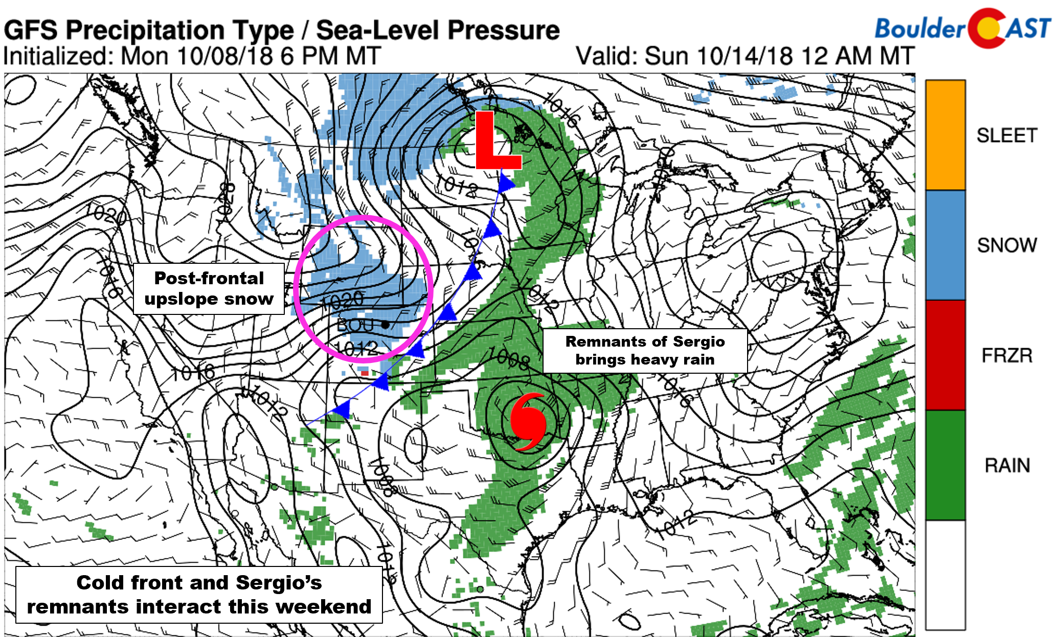
GFS precipitation forecast for Saturday night. A cold front may bring snow to the Front Range, with heavy rain for Kansas/Oklahoma from Sergio’s remnants.
Don’t forget, Thursday (October 11th) is the last day to take advantage of our pre-winter promotion. Save 30% on BoulderCAST Premium with promo code SNOW. Click here.
Finally, in case you missed it, don’t forget to read our important announcements about BoulderCAST this winter.

That’s a lot of blue!
Forecast Specifics:
Tuesday: Patchy fog and drizzle in the morning, then cloudy with isolated showers in the afternoon and evening. Showers will be snow in the Foothills, and a rain/snow mix across the Plains. Highs near 40 degrees on the Plains and in the middle 30’s in the Foothills.
Wednesday: Mostly cloudy and cool with isolated banded snow showers across the Foothills with rain and maybe a snow shower for the Plains. These bands could produce brief white-out conditions in the higher elevations, with a quick inch or two of accumulation in spots. No accumulation is expected for the Plains. Highs in the upper 30’s for the Plains with middle 30’s in the Foothills.
Thursday: Mostly cloudy with isolated afternoon and evening rain showers on the Plains, with snow showers in the higher Foothills. Little to no accumulation expected. Highs in the lower 50’s for the Plains and lower 40’s in the Foothills.
Friday: A few morning clouds, then sunny and noticeably warmer. High temperatures climbing to near 60 for the Plains, with upper 40’s in the Foothills.
Saturday: Increasing clouds through the day with a cold front moving through. Latest model trends show rain changing to snow across the Front Range. This system, while weak, will need to be closely monitored. Expect highs in the 50’s across the Plains and in the 40’s in the Foothills (and potentially dropping through the day depending on the frontal timing).

High Country: Unsettled weather will be the story in the Mountains Tuesday through Thursday this week. Isolated to scattered snow showers will be possible, with a rain/snow mix in the valleys. Some snow bands on Tuesday and especially Wednesday could produce brief white-out conditions and even some thunder. Friday will be quiet with sunshine and moderating temperatures. Check out our SummitCAST page for 6-day forecasts for more than 120 Colorado mountain destinations!
DISCLAIMER: This weekly outlook forecast was created Tuesday morning and covers the entire upcoming week. Accuracy will decrease as the week progresses as this post is NOT updated. To receive daily updated forecasts, subscribe to BoulderCAST Premium.

.
Share our forecast!


You must be logged in to post a comment.