We discuss the very chilly temperatures for your Friday, the quick warm-up headed our way for the weekend, and the possible impacts of Hurricane Rosa’s remnants early next week.
Cold today, hot tomorrow
As you may have noticed this morning, the autumn chill has returned to the Denver Metro area. Yes, a cold front moved through just before midnight last night with temperatures now in the low to middle 40’s across the lower elevations. It’s easy to pick out the cold airmass across eastern Colorado in the 800 mb temperature map below.

GFS 800mb temperature map for Friday at noon showing the cold front progression
Notice how the cold air is banked up against the Foothills. This is because the cold airmass is too shallow and doesn’t have enough forcing to push beyond the topographic barrier west of town. This is very typical for backdoor cold fronts. The high-resolution NAM forecast sounding below indicates that the cold airmass only extends up to around 775 mb. This is near an elevation of 7,500 feet.

NAM model forecast sounding for Denver. The red (green) line is temperature (dew point).
Above this level, temperatures will remain warm and above normal today, similar to the last few days. Skies are also clear as can be:

Down on the Plains, we are downright chilly and clouds are socked in. Expect overcast skies to stick around for much of the day, with temperatures only reaching the middle to upper 50’s.

Fear not, though. The cold won’t be hanging around long. Early Saturday morning, westerly flow will once again take over across Colorado and oust the cold airmass. We should see a rather abrupt jump in temperatures as the warm air aloft mixes back down to the surface Saturday morning. And with plentiful sunshine, temperatures will skyrocket back into the 80’s. It’s hard to believe that such a warm day could follow one so cold. But alas, this is Colorado!

GFS 800 mb temperature forecast for Saturday morning showing warm returning to eastern Colorado.
Monitoring the tropics early next week
Rainfall totals this month in Boulder and Denver are 1.02″ and 0.18″, respectively. With a near-zero chance of any rainfall through the rest of the weekend, we won’t be adding any more before the calendar flips to October. As you may expect, these totals are well below normal. The same pattern that brought three consecutive weeks of above normal temperatures for northeast Colorado has also limited our precipitation greatly. Fortunately, we are seeing strong signs that some precipitation may be headed to our region early next week as the remnants of Hurricane Rosa move into the Four Corners region, something which we have been discussing this with our Premium members over the last several days.

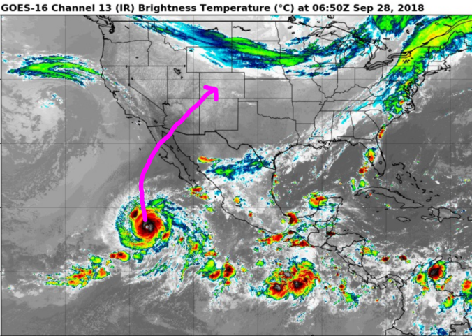
Rosa is currently a powerful Category 4 hurricane with 145 mph sustained winds and is heading westward away from Mexico. Beautiful….isn’t she? Based on satellite observations, I’d say Rosa probably briefly reached Category 5 overnight.

Water vapor loop of major Hurricane Rosa from Thursday evening
Due to the presence of a deep trough across the eastern Pacific, Hurricane Rosa will get turned-around and swept into Baja California this weekend. The storm will be moving over much colder waters before landfall, so it will most likely weaken to a tropical storm before moving on-shore into Mexico….good news for sure.
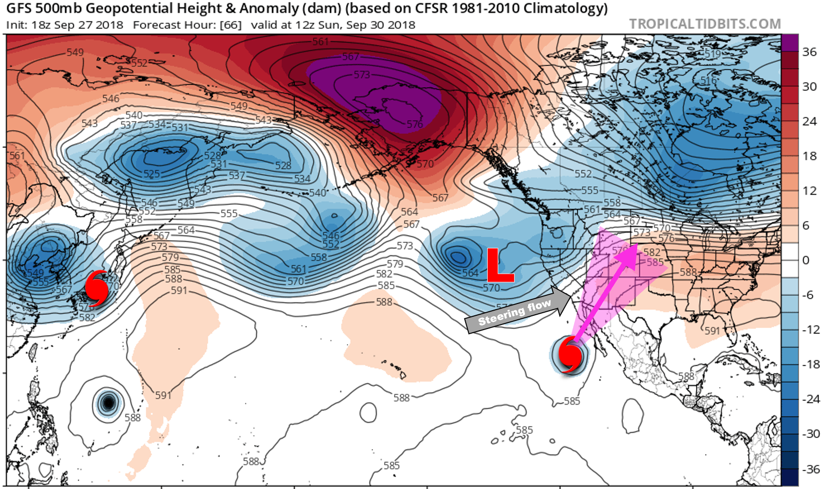
GFS 500 mb height anomaly forecast for Sunday morning. An approaching trough on the West Coast will help steer Rosa into the Desert Southwest
The specifics of this landfall really don’t matter so much for our interests here in Colorado. The important aspect is that afterwards, the remnants of Rosa will move into the Desert Southwest and possibly across Colorado by Tuesday or Wednesday of next week. The latest runs of various hurricane models show a clear agreement in Rosa moving into Arizona and eventually Colorado.

Forecast tracks for Rosa from numerous models
A direct hit of the remnants across Colorado could have substantial impacts resulting from the influx of deep tropical moisture. The last several runs most models produce new all-time October record moisture levels for most of Colorado. The latest GFS precipitable water forecast is shown below. More than 1″ is projected in Denver on Tuesday….extremely juicy by October standards.

GFS precipitable water forecast for Tuesday evening. Greater than 1″ is forecasted in Denver.
In fact, precipitable water in Denver has never exceeded 1″ during the month of October (red line below).
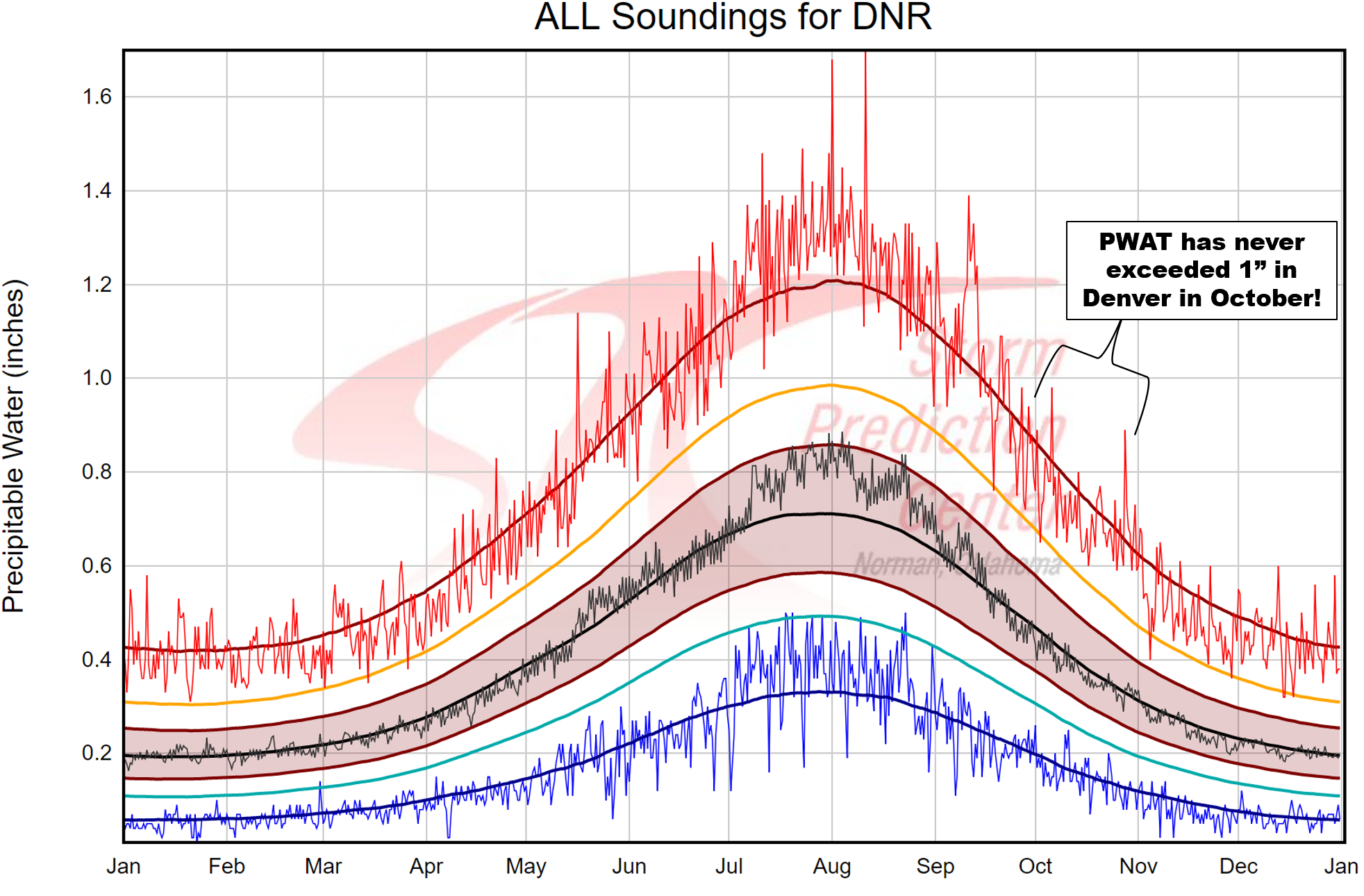
Climatology of precipitable water from all balloon launches in Denver. The red line is the all-time record precipitable water observation for each date.
The final factor of the forecast worth discussing is the speed of the remnant tropical cyclone. An approaching trough/cut-off low pressure in southern California will produce strong winds to push Rosa northeastward through the Four Corners region and into the Great Lakes. The large-scale steering flow across Colorado is expected to be 30 to 40 knots from the southwest by Tuesday. This means Rosa’s impact will likely be brief where ever she hits. Thus, we’re not really expecting any prolonged rainfall. Still, given the tropical moisture in play, heavy downpours will be possible.

GFS 500 mb wind and vorticity forecast for Tuesday. Strong steering flow (30-40 knots) is expected to rapidly push Rosa’s remnants northeastward.
Rosa’s arrival is still four days away. Given the quick movement of the storm, any deviation in the current track could mean almost no impact at all for the Denver Metro area. The worst case scenario doesn’t look that bad either, but any rain is good rain for our state right now. Western Colorado, which needs the precipitation the most, stands the best chance of seeing a period of soaking rain and flooding from Rosa’s heavy downpours. Things at this time are a little more uncertain for eastern Colorado, but we can say at least light to moderate rainfall looks probable.

For now, plan on warm days and crisp mornings through Monday with partial sunshine and temperatures in the 70’s and 80’s for the Plains. Tuesday and Wednesday of next week should be cloudier with the remnants of Rosa possibly bringing a period of moderate rainfall to the Front Range and much of Colorado. That trailing cut-off low could also keep things unsettled through Wednesday. That, however, is even more uncertain than Rosa at this time.
We’ll have a clearer picture on where Rosa is going and the overall impact for us by Monday’s weekly forecast. TGIF!

.
Share our Hurricane Rosa forecast:


You must be logged in to post a comment.