
Look for cold temperatures and a wintry mix on Monday, followed by a return to mild weather come midweek thanks to downslope winds across the Foothills and Plains. Read on for our spooky forecast for Halloween and the upcoming week.
Much of this week’s weather can be summed up in one figure: a time-height plot of temperature, winds, and relative humidity (see below). Of importance today is the area highlighted in orange on the bottom left. This airmass is from last night’s cold frontal passage, spawning low clouds, upslope flow, and some light snow. On Wednesday, we’re watching for a potential downslope wind event (top right and bottom right) that may bring a round of wave clouds to the area. The downslope winds may exceed 50 mph Tuesday night and early Wednesday in the Foothills, aiding a return to mild weather by midweek.
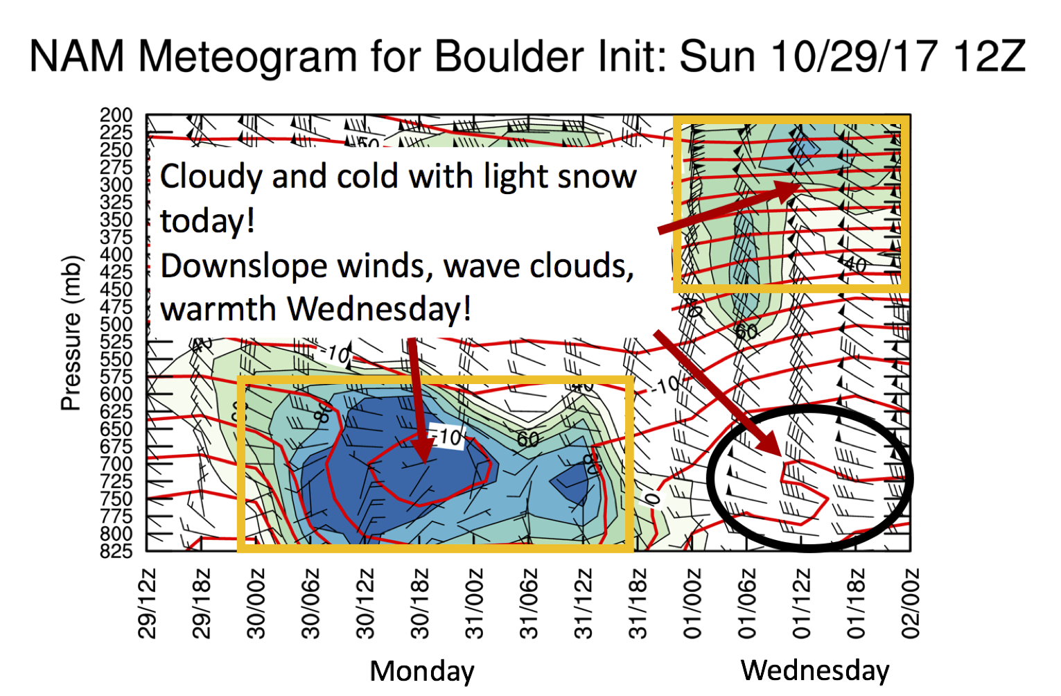
NAM model time-height plot of temperature, wind, and humidity for the next few days
Specifics of our forecast are discussed below….
Cold front reminds us winter is near
What a change from where we were yesterday! Isn’t it amazing how Colorado can be in the 70’s one day, and 30’s the next? Below shows the surface temperature forecast for today across Colorado. With the cold airmass in place, in conjunction with upslope flow, clouds, and light snow, temperatures will remain in the mid 30’s this afternoon.
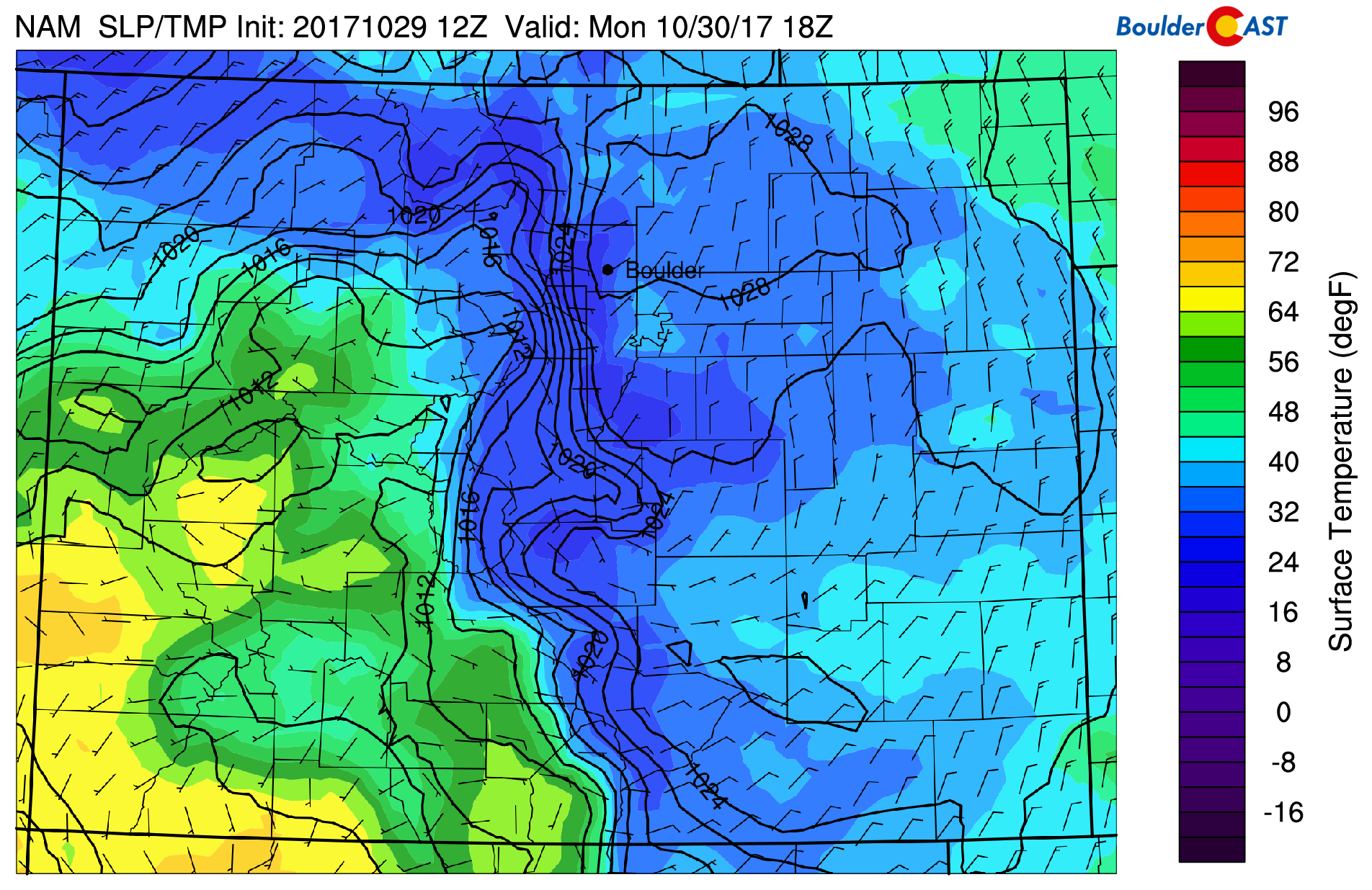
NAM model surface temperature forecast across the state today
In the upper-levels today, you’ll notice that we are situated between three weather systems, (1) one over the Great Lakes, (2) a second over northwestern Nevada, and (3) another over Baja California. Northwest flow ensues across Colorado tied to the trough in the mid-section of the country, which aided the frontal passage last night.
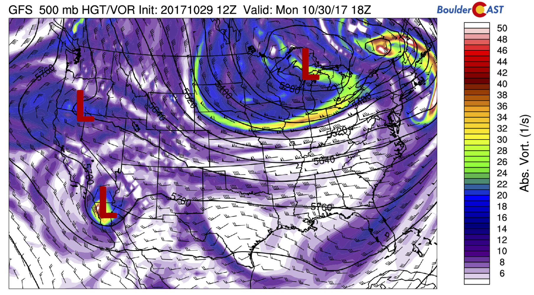
GFS 500 mb absolute vorticity for today
The upslope flow today will keep the low clouds socked in across the region, as is evident below with humidity values approaching 80-90% at the 700 mb level.
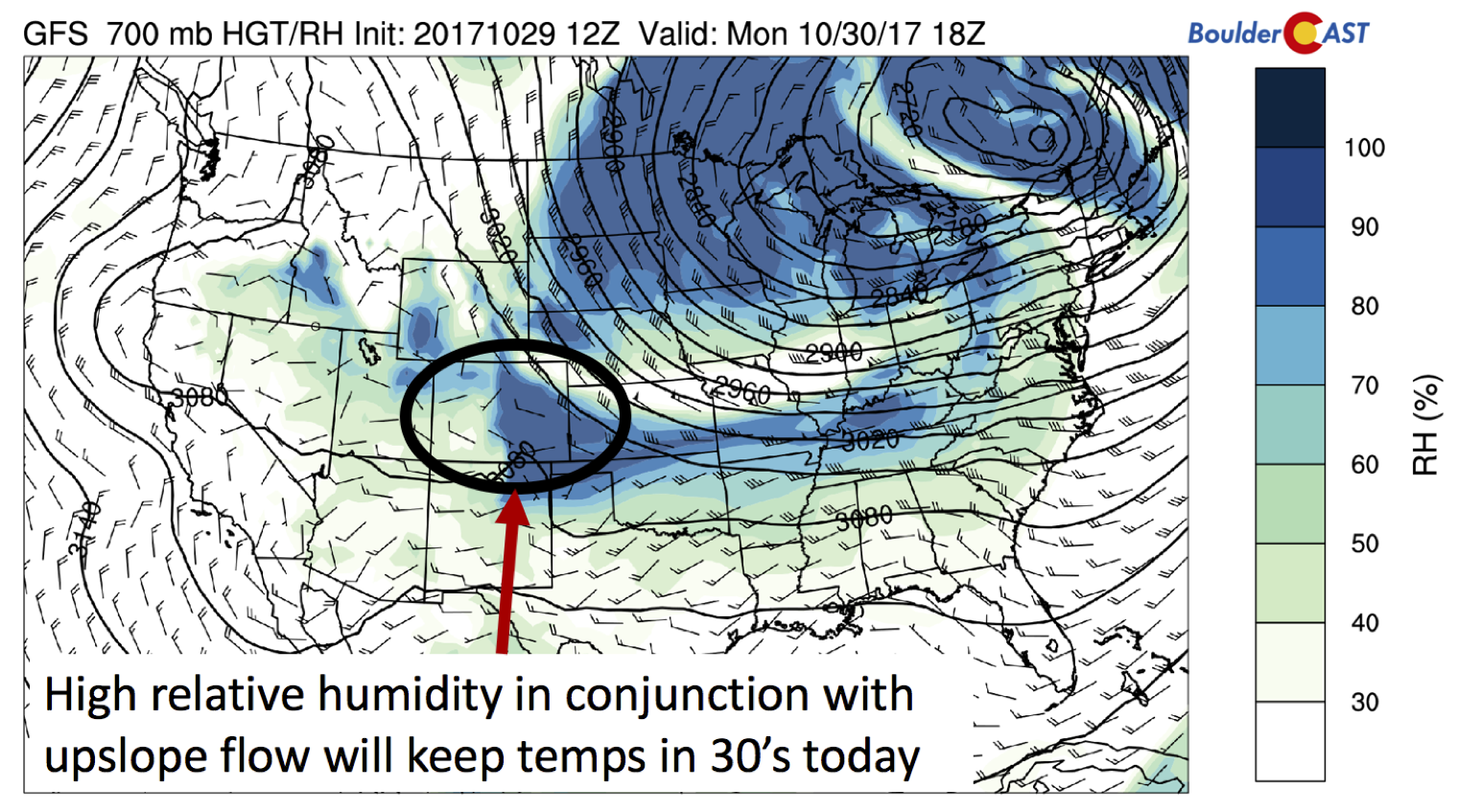
GFS 700 mb relative humidity (shaded) and winds today
Temperatures in the atmospheric column have turned cold enough for freezing precipitation overnight. Some light freezing drizzle is possible this morning, so we hope you take it easy on your Monday morning commute. Any freezing drizzle will transition to all snow later this morning , with light snow showers tapering off by mid afternoon.

BoulderCAST Station weather as of 7:30 AM Monday. Freezing drizzle and fog is reported.
Another surge of light snowfall will ensue after sunset tonight for mostly the southern Denver Metro area. We are not expecting much accumulation, generally less then 1/2″ across the Plains, with up to 2″ in the nearby Foothills.
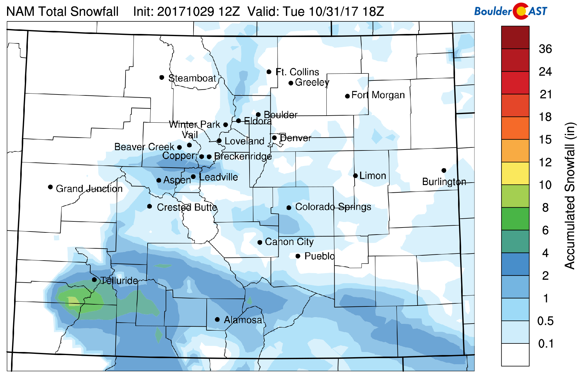
Forecast total snowfall by Tuesday afternoon
We mentioned in a post last week about possible snow for Halloween. The system has continued to trend further and further south of the Denver Metro. In fact, the system will remain shunted to the southwest part of the state, aiding in some decent snow for southwest Colorado ski resorts (3-8″)!
Trick-or-Treat Forecast
Now for your spooky Halloween forecast!
In the upper-levels, there’s not much to speak of early on Tuesday. The trough in the middle of the CONUS slides east, but a piece of the upper-level jet remains parked over southwestern Colorado, a region favored for lift. This combined with moisture in place will aid in some decent snowfall for the Mountains in this area. Over our region, we’ll likely start out cloudy and cold, with partial sunshine developing in the mid to late afternoon and temperatures warming into the 40’s.
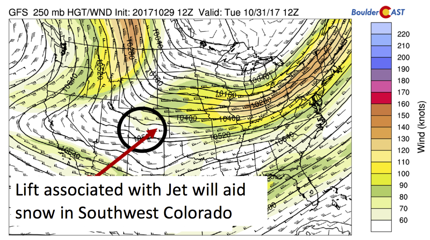
GFS 250 mb jet stream and height pattern Tuesday
Tuesday night, skies will be clearing allowing for temperatures to drop back into the 30’s for trick-or-treaters, so bundle up with a coat or jacket on the way home. Later in the evening and overnight, a quick transition will unfold. As an upper-level jet approaches from Wyoming, a strong pressure gradient is expected to set-up across the Foothills and Plains, with west-northwest downslope flow ensuing. It’s unclear exactly how strong the winds will be across the lower elevations as the forecast may change between now and tomorrow, but current indications are that winds could exceed 50 mph overnight. The breezes may start as early at 9 PM on Halloween and create that eerie feel to end the holiday. They will also transition us from the 30’s into the 50’s overnight.
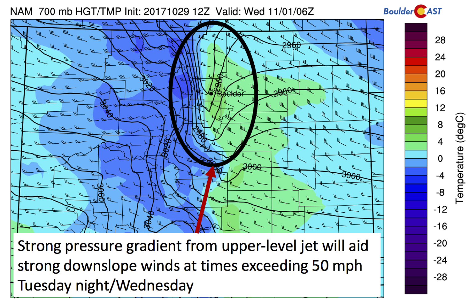
NAM model 700 mb temperature and wind forecast Halloween night around midnight
Wednesday: Warm & breezy
By mid-week, on the first day of November, we’ll see our temperatures jump significantly thanks to downslope warming tied to the Halloween winds mentioned above. We wouldn’t be surprised if the lower elevations approach the lower 70’s once again, similar to Sunday. Low relative humidities and breezy conditions during the day – at times exceeding 30 to 40 mph in the morning, could produce high fire danger for the Front Range.
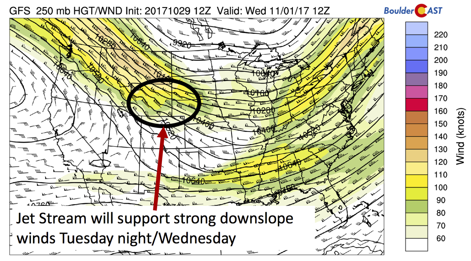
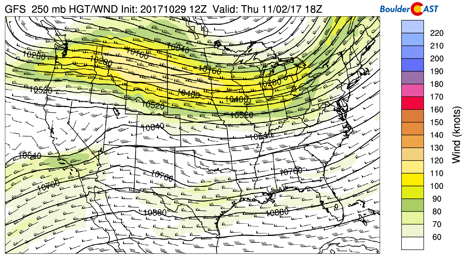
GFS 250 mb upper-level jet stream Wednesday
Mild weather continues into late week…we think
Come Thursday, a west-east oriented jet stream looks to be in place across the state. Some of the global forecast models are hinting that a weak frontal boundary may sag south across northeastern Colorado. Current trends are to keep this front east of the Denver Metro, with highs remaining on the mild side. However, we feel a little uncertain for Thursday given the close proximity of the front. If it gets closer, we could see highs a tad cooler than what we are forecasting at the moment.
On Friday, westerly flow in the mid and upper-levels remains across much of the CONUS (see below). That should keep the area in that mild pattern with 60’s to end the week. In the extended, we’re watching a trough across the West. However, current ensembles point to this trough skirting the northwestern part of the state. Any moisture would start out as rain, possibly ending as snow early next week. It’s too uncertain at this point.
GFS 250 mb jet stream and heights for Friday
Have a great week and enjoy your Halloween!
Forecast Specifics:
Monday: Overcast skies and cold. Freezing mist in the morning will transition to light flurries by late morning. Another round of snow may clip the southern Denver Metro area Monday evening. Expect total snow accumulations less 1/2″ across the Plains, with up to 2″ in the Foothills. Highs will be in the mid 30’s for the Plains and middle 20’s in the Foothills.
Tuesday: Mostly cloudy and cold in the morning, followed by partly sunny skies in the afternoon. High temperatures in the upper 40’s across the Plains and upper 30’s in the Foothills. West-northwest winds developing Tuesday night, potentially exceeding 50 mph in and near the Foothills.
Wednesday: Breezy, partly sunny, and warmer with upper 60’s to low 70’s on the Plains and lower 60’s in the Foothills. West-northwest winds may exceed 50 mph in and near the Foothills.
Thursday: Partly cloudy and warm with highs in the mid 60’s over the Plains and mid 50’s in the Foothills.
Friday: Mostly sunny and mild with temperatures in the mid 60’s on the Plains and mid 50’s in the Foothills.
Weekend: The upcoming weekend looks relatively quiet across the state of Colorado. We’re watching a trough late in the weekend which may impact the state Sunday. Expect mild weather to remain at this point, with a trend to cooler weather next week.
High Country: The mountains will see snowfall tonight and tomorrow, generally across southwestern parts of the state, with 4-8″ in this region. Elsewhere, 1-3″ can be expected to the north and northwest. Dry and mild weather persists from Wednesday through Friday. The next chance of mountain snow may not be until late next weekend. Find the latest forecast for all your favorite Colorado ski resorts on our PowderCAST page.
DISCLAIMER: This weekly outlook forecast is was created Monday morning and covers the entire upcoming work-week. Accuracy will decrease as the week progresses as this post is NOT updated. To receive daily updated forecasts, subscribe to BoulderCAST Premium.

Share our forecast:
Mon
Tue
Wed
Thu
Fri


Temperature
35
50
70
66
66


Precip Chc (Plains)
80%
0%
0%
0%
0%


You must be logged in to post a comment.