We hope you had a joyous Easter holiday weekend. The last two weeks have been very snowy across the Front Range, with nearly three feet falling in the city of Boulder. The trend continues for the week ahead as we monitor yet another powerful spring snow storm set to churn across the northern Rockies. Uncertainty is still high, but the chance for significant snow does exist. Continue reading for our full outlook.
Saturday’s snow recap
A weak system moved through early Saturday morning, bringing with it a chance of light snow to the region. Our forecast called for 1-3″ across the area. Shown below is our original forecast snow map (issued Friday morning), with the observed storm totals per location contained in boxes. Green ones indicate that the observed snowfall was within one inch of the given forecast range, while red was outside the scope of our forecast.
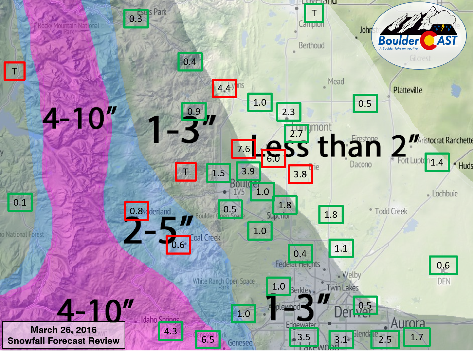
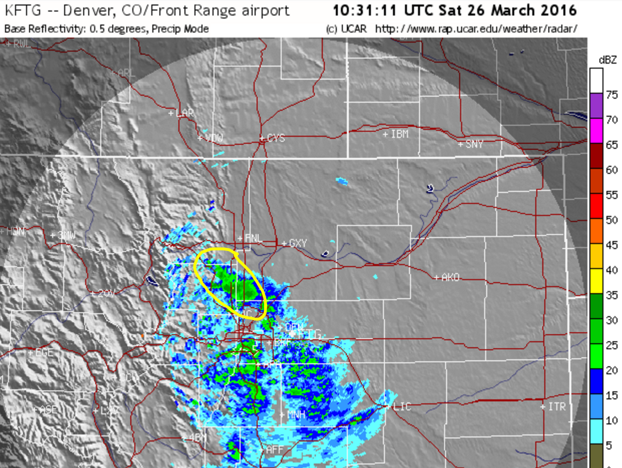
An over-producing, heavy snow band set-up band just northeast of Boulder during the early morning hours on Saturday. It was just a few miles wide. The big winner was Niwot, which accumulated 6 to 8″ of snow overnight! That band, depicted at 4:30AM Saturday, is shown in the radar image below. Otherwise, it was a fairly good forecast for the rest of the Denver Metro.
March may go out with a bang!
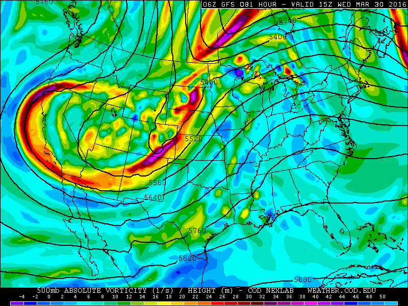
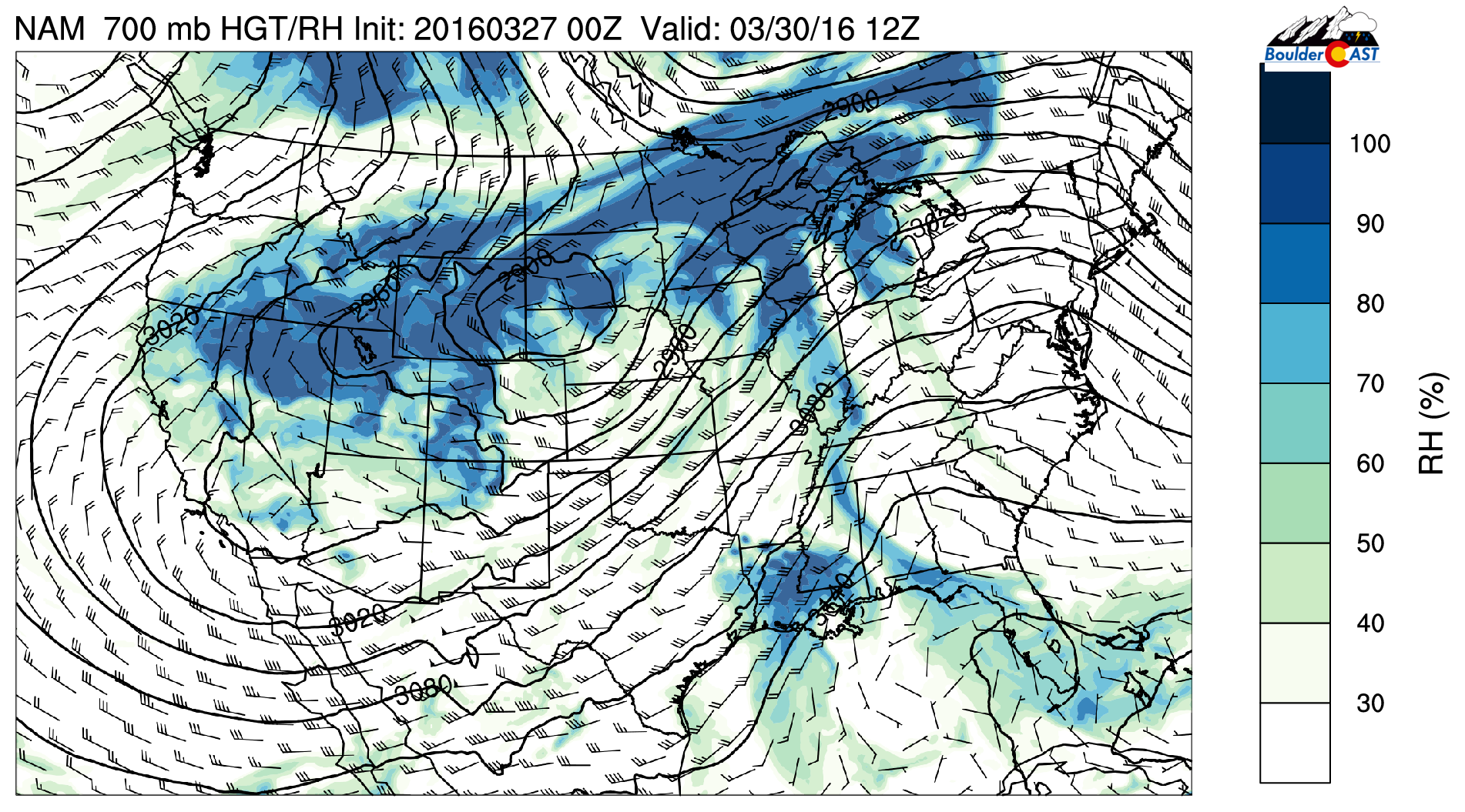
The week begins calm under the influence of an upper-level ridge, seen below in Monday’s 500 mb vorticity map from the NAM. However, our next weather system is already knocking on the door — that big trough to our northwest.

NAM 500 mb vorticity map, valid this morning, showing ridging over eastern Colorado with our next weather system already shore in the Pacific Northwest.
Ahead of the trough, we’ll be in a southwesterly flow regime, which will facilitate warmer temperatures (near 60 degrees) for Monday and Tuesday, with plenty of sunshine. Clouds will be on the increase Tuesday afternoon, however. Moisture and snow will spread into the mountains of western Colorado Monday evening, with snow beginning in the northern mountains by early afternoon Tuesday.
That is as far as the models agree…
Want snow? Bet on the Euro.
There are some big differences on how the models are handling the trough’s behavior. Therefore, how things are going to evolve Tuesday night into Thursday, and ultimately, how much snow we end up with, depends on which model you want to believe. For the gambling folks out there, here are your options:
- GFS: The trough becomes elongated with a piece of energy breaking off and moving westward into California. Most of the energy sticks with the jet stream, which results in a bulk of the snow remaining in eastern Wyoming and SE Montana. The Denver Metro picks up light rain/snow Wednesday during the day as the trailing cold front moves through. This scenario brings 1-4″ to the Plains, more towards the Wyoming border.
GFS 500 mb vorticity map valid Wednesday morning. The trough elongates and a piece cut-offs westward towards Colorado. A tricky situation to model, to say the least.
- NAM: The NAM is similar in the way it handles the 500 mb set-up, but develops a deep 700 mb low further south in southeast Wyoming. As a result, this downslopes the Front Range and produces less than 3″ on the Plains (more north and east of Denver)
NAM 700mb relative humidity forecast for Wednesday morning, show the 700mb low in eastern Wyoming and downslope across NE Colorado
- Euro: The Euro delays the elongation of the trough a little longer. This allows the main energy to dig further south. The eventual track of the low is across east-central Colorado, a much more favorable spot for snow in Denver. This scenario brings the potential for 6-12″ for the Plains Wednesday evening.
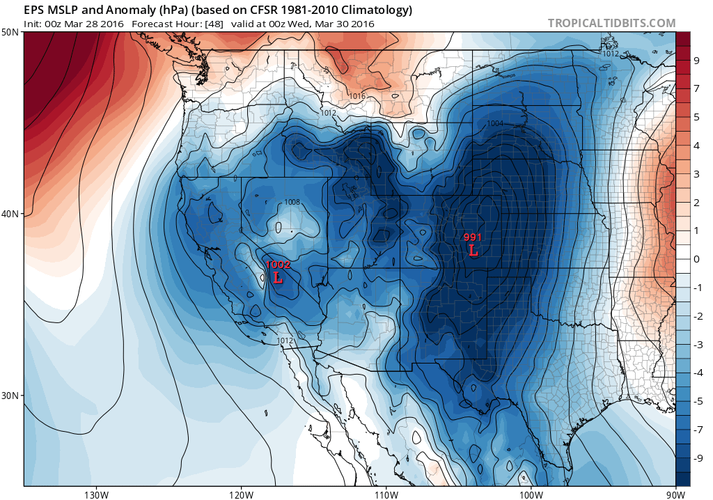
Sea-level pressure forecast from the Euro for Tuesday evening showing an elongated surface low in eastern Colorado. The exact positioning will have big implications.
At this point, the best area for significant snow will likely be in the vicinity of Cheyenne or slightly north. However, the Euro did relatively well with our last two big storms, so the potential is at least there across our region. For now, expect the chance of snow from Tuesday night into late Wednesday night, with mostly cloudy skies. The best chance looks to be Wednesday afternoon and evening as the cold front moves through. The daytime onset could see rain mixing in as well. Temperatures will be somewhere between 35 and 45 degrees Wednesday, depending on the eventual track of the system.
The GFS snowfall forecast through midday Thursday is shown below. Notice the heavy mountain snow and higher totals remaining near and north of the Wyoming border.
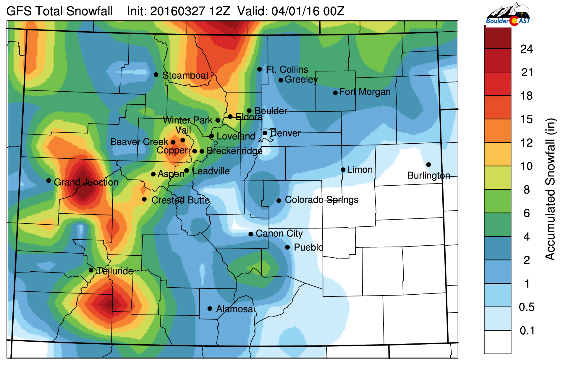
GFS snowfall forecast through Thursday. Heavy mountains snow and on the Plains near the Wyoming border.
We’re thinking a couple of inches, mainly Wednesday afternoon and evening, right now for the Plains (predominantly north of Denver). Check back tomorrow for updates. Northeast Colorado has stolen the last few storms from Wyoming in the final hour. It’s only fair if we share sometimes, right?
The precise happenings on Thursday and Friday will no doubt depend on the outcome of the trough’s movement and evolution. However, under northwest flow, cool weather will continue. Thursday’s 500 mb map shows the main trough pulling away into the Great Lakes, with that detached piece of energy lingering across Arizona. This leaves weak NW flow across Colorado.
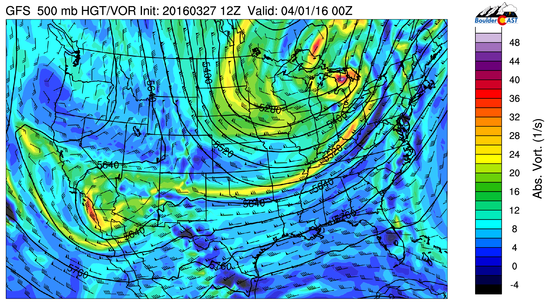
GFS 500 mb vorticity map, valid Thursday evening. Weak NW flow is present over Colorado
Several of the models have a weak system entrenched in the flow over Colorado for Thursday, bringing a cold front through in the evening, with a chance of light snow overnight into Friday. As of now, the biggest impacts will be some cloud cover for the second half of Thursday and the first half of Friday, and temperatures remaining cool into the weekend, near 50 degrees for afternoon highs.
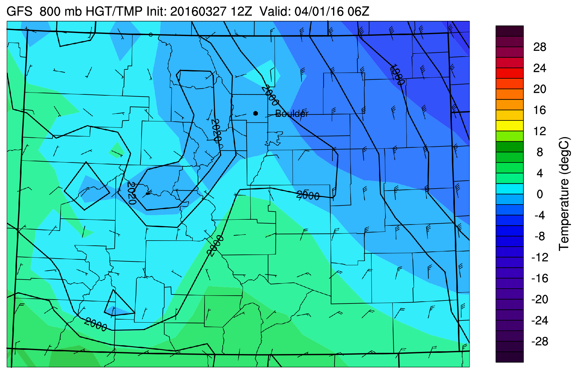
GFS 800 mb temperature and wind forecast for Thursday night, showing a cold front moving through NE Colorado
Beyond Friday, conditions look to remain calm across Colorado for longer than we’re now used to. However, there is indication that the active pattern will continue (in some form) as April wears on.
We’ll be sure to pass along any updates to Wednesday’s tricky forecast. Stay tuned!
The Forecast:
Monday: Mostly sunny and mild. High clouds building through the day. Highs in the low 60’s for the Plains, with low 50’s in the Foothills.
Tuesday: Partly cloud early, with increasing clouds through the day. Scattered rain showers developing in the late evening changing to snow overnight. Little, if any, accumulation expected. Highs in the low 60’s across the Plains, low 50’s in the Foothills.
Wednesday: Overcast and cooler. Snow showers developing in the afternoon, lingering into the evening. A few inches of accumulation will be possible. Highs in the low 40’s across the Plains, low 30’s in the Foothills (before the front passes).
Thursday: Mostly cloudy with a chance of light rain changing to snow in the evening and overnight into Friday. Little accumulation expected at this time. Highs in the upper 40’s across the Plains, with upper 30’s in the Foothills.
Friday: Partly to mostly cloudy. Dry with highs in the low 50’s for the Plains with upper 30’s in the Foothills.
High Country: Snow will redevelop in the mountains Tuesday afternoon and continue through Wednesday night. It could be heavy a times, especially Tuesday night. 6-12″ is likely by Wednesday evening, with more towards the Wyoming border. After a brief lull in the action Thursday, light snow will increase Thursday night into Friday, with light accumulation expected to end the week. By far, the best powder day is Wednesday!
Header photo credit: Zack Pyle


If you would like to use my Flatiron’s picture in your header image, please give credit. I don’t appreciate stealing.
Thanks,
Zack
Hi Zack,
We would be happy to give credit for the image and apologize if we did indeed use your photo. Which one are you specifically referencing? Thanks!
Hi. Thank you. It is the image at the top of this article. The Flatirons picture in the “This Week In Weather” graphic.
You can see my image here: http://www.gigapan.com/gigapans/168949 and here: https://zackpyle.com/for-fun-landscapes/j5idmhze0l2b785s2lq4n3m1oxst7e
Thanks,
Zack Pyle
Great shot. Credit has been added at the bottom here and anywhere else this was used (about 6 other spots that we could find). We also have no qualms linking to talented photographers, so we did that as well. Take care!
I appreciate that! Thanks!