After a smattering of rain last night, cool and dreary weather will prevail on Monday. However, we’ll warm back up and (mostly) dry out in no time. For the end of the week, we’re monitoring the arrival of a powerful weather system which will likely bring rain and snow back into the picture for the weekend. Read on for our full outlook for the week ahead.
Beginning cool and dreary
Rain totals across the Boulder/Denver area from last night’s storm generally range from 0.1 to 0.4″, while snow accumulations up to 3″ were reported in the nearby Foothills. This was towards the low end of model guidance, especially over Boulder County. The northern suburbs of Denver made out the best (Broomfield, Thornton, Commerce City), nearing a half inch of rain. We only measured 0.10″ in North Boulder.
The system responsible is currently located over the Texas Panhandle, and is sluggishly moving eastward (seen below).

GFS 500 mb vorticity map valid Monday afternoon. This morning’s rain maker moves east, with another weak system in its wake to our west.
Notice the weak northwesterly flow over Colorado today. Some residual moisture will provide just enough instability in the Mountains to produce spotty showers and a few rumbles of thunder this afternoon. The Plains will remain mostly cloudy with only a slight chance of an afternoon shower (greater stability and clouds will limit activity). Temperatures will be chilly, only in the low to mid 50’s.
It’s going to seem like monsoon season
In the 500 mb map above, there is a secondary storm system visible, to the west in Baja California. That system moves east, tracking right along the United State/Mexico border and will be south of Colorado Tuesday evening and night, shown below.

GFS 500 mb vorticity map for Tuesday evening. Notice the trough to our south, and the ridge to our north
Though there is troughing to our south with that aforementioned system, there is also ridging directly to our north. Yep, this is another split-flow pattern! Colorado is stuck in the doldrums. Look at those 500 mb wind speeds above…5 to 10 knots! Very calm for April; something more typical for July!
Northern Colorado will see more influence from the ridge than the trough. With just enough moisture in place, and the ever-increasing influence of the sun, Tuesday afternoon and evening will spawn more showers and thunderstorms, mostly in the higher terrain. The NAM’s forecast precipitation map below shows the potential coverage extent. A few showers could spill out on the Plains, though. Highs will be in the upper 60’s.
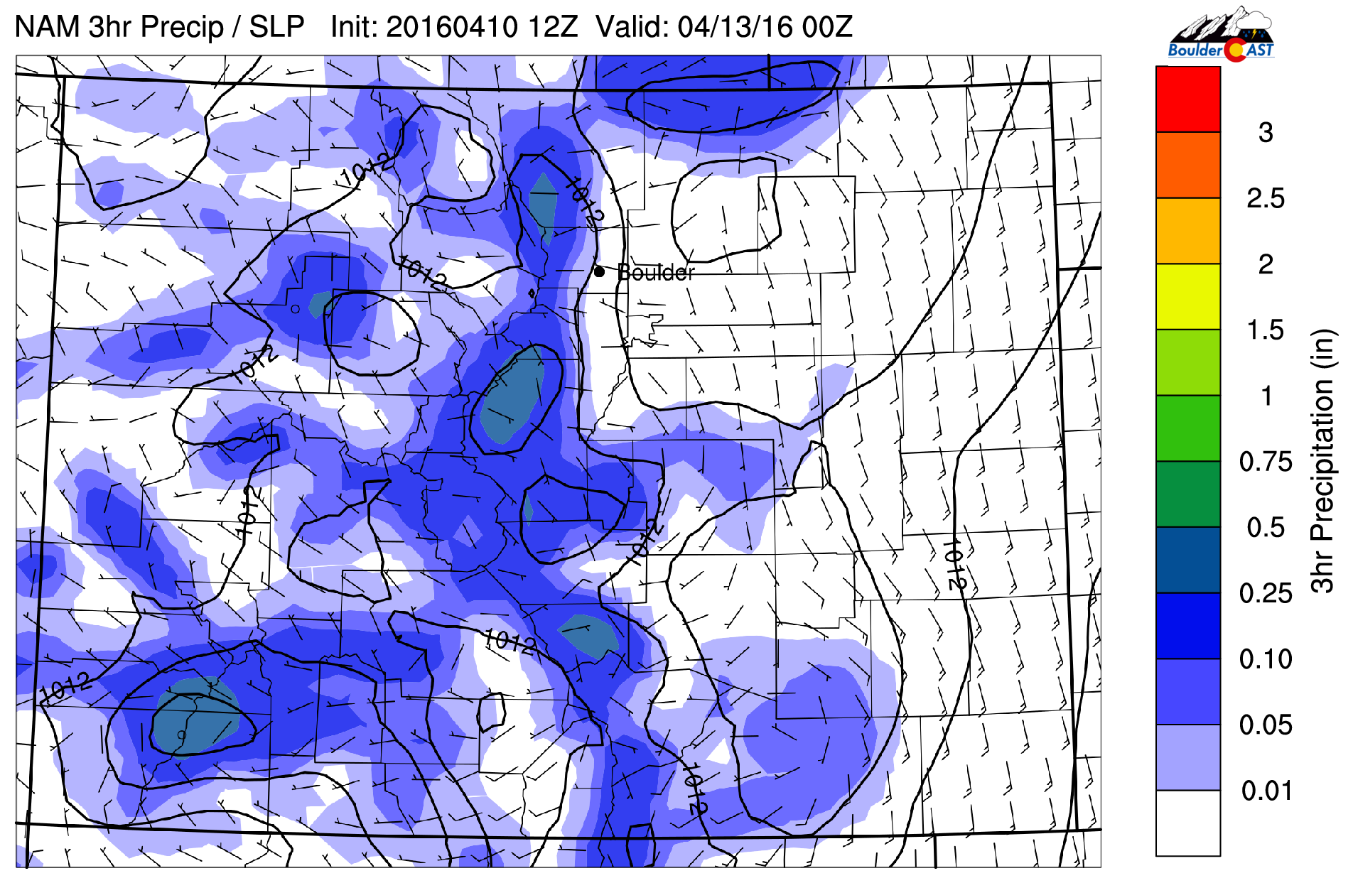
NAM pressure and precipitation forecast for Tuesday afternoon. Scattered shower and storm activity is expected, mostly over the higher terrain
As we move into Wednesday and Thursday, afternoons will begin to feel like the summer monsoon has started three months early! We’ll see temperatures climb into the mid 70’s, a mix of clouds and sun, and the threat of afternoon storms both days. The best chances will once again be over the Mountains and Foothills, but there is a slight chance over the Plains as well. Thursday even has a shot at being our first 80-degree day of 2016!
Watching the weekend closely
Enjoy the warmth and sunshine while you can. Models have a potent storm system swinging into the central Rockies Friday. The forecast map below is for Thursday evening. Look at the change in 700 mb temperatures ahead of the trough and within. 10 degrees C in SE Colorado, -12 degrees C in western Oregon. This system has cold air to work with!
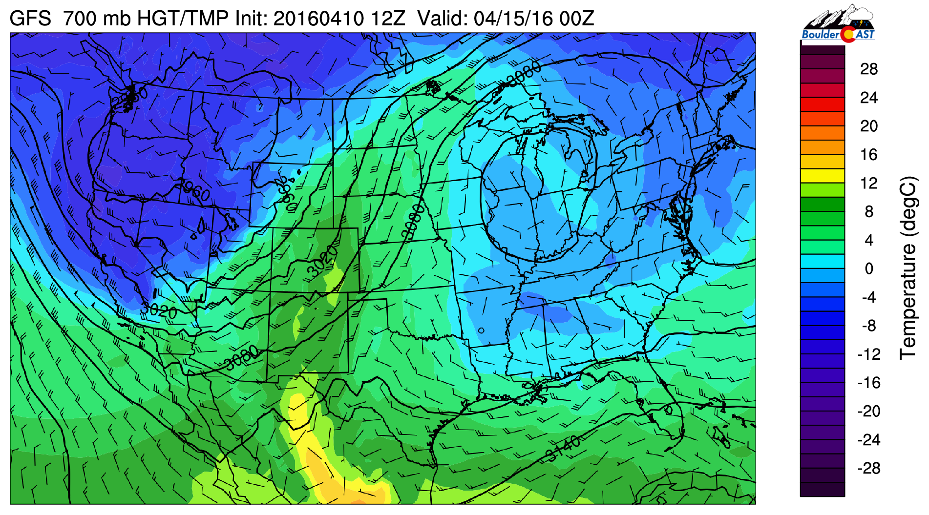
GFS 700 mb temperature map for Thursday evening. Notice the warm temperatures across Colorado, with a much cooler air mass lurking to the west
How exactly the trough progresses remains to be seen. There is decent model agreement (considering it is five days out) of the trough cutting off over the Four Corners region, with a big blocking high over of the Great Lakes (will help slow the system down).

GFS 500 mb vorticity map for Saturday evening showing the potential position of the cut-off low. This is the near perfect spot for Front Range upslope (maybe just a shade too far south)
This produces rain and snow across the Front Range from Friday evening into Monday. We’ll be tracking this system very closely through the week. Wherever the eventual track sets up will have the potential for an extended period of precipitation. And as of now, the cold air could be there for some snow at all elevations.
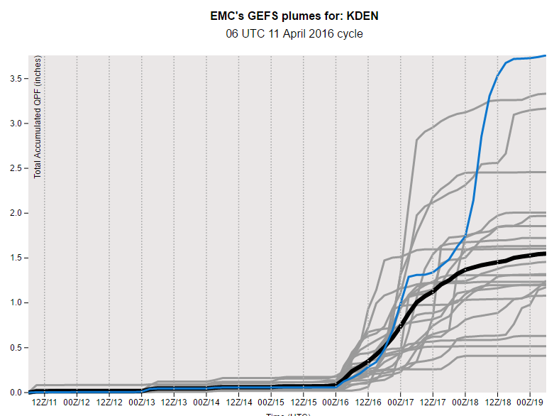
GEFS total accumulated precipitation plume for Denver. Big precip totals are projected for the weekend. However, there is a large amount of spread and high uncertainty
The intensity, track, and speed are concerning to say the least as of now. A lot can happen between now and Friday, though. We’ll keep you updated. For now, expect cooler temperatures than Thursday, with the chance of late day rain showers and storms.
The Forecast:
Monday: Overcast and chilly, with light rain/drizzle ending by mid-morning. There will be some isolated afternoon shower/storm development, mostly over the higher terrain. Above 9,500 feet this will be snow, with less than 1″ of accumulation. Highs in the mid 50’s over the Plains and mid 40’s in the Foothills.
Tuesday: Partly cloudy with scattered showers and a few storms developing in the afternoon in the Mountains/Foothills. A couple storms could roll off onto the nearby Plains as well. Highs in the upper 60’s for the Plains, upper 50’s in the Foothills.
Wednesday: Partly cloudy and warm. A few isolated showers or storms will be possible in the Foothills. Highs in the low 70’s across the Plains, with low 60’s in the Foothills.
Thursday: Mostly sunny early with increasing high clouds. Extremely isolated storms possible in the Mountains. Dry elsewhere. Highs in the mid to upper 70’s across the Plains, with mid 60’s in the Foothills.
Friday: Increasing clouds with showers and thunderstorms developing in the evening. Highs in the mid 60’s on the Plains, with upper 50’s in the Foothills. There is large uncertainty for Friday, depending on the arrival of the trough. It could be much colder with precipitation beginning earlier, or a little warmer and mostly dry.
High Country: After several inches of snow Monday morning, snow levels raise to ~10,000 feet most of the week. Each and every day will have afternoon showers and thunderstorms forming. The best chances are Monday and Tuesday afternoons. Thursday has the lowest chances. The threat of accumulating snow returns for the second half of Friday and through the weekend as that big trough arrives. As of now, both Saturday and Sunday could be good powder days.
Header photo credit: Zack Pyle


