
We hope you enjoyed the snowy and cold Veterans Day holiday! We first review the totals from the light snow event yesterday, then take a look at the weather transpiring the rest of the week. Things get interesting just in time for the weekend!
Veterans Day Snow Recap
How did you like the brief dose of snow yesterday? As a whole, the snow event played out exactly as we forecast in almost every single way. From the timing of the initial front, to the change-over from freezing drizzle into snow after midnight, to the quick wrap-up of everything giving way to sunshine by Monday afternoon….it all went as planned. This isn’t saying much, though, as it was a relatively easy forecast with little that could have gone wrong.
The meager amount of energy that pushed across Colorado Sunday night was the result of a long trough axis tracing back to an Arctic low all the way in the Great Lakes region. The 500 mb vorticity animation below shows the linear trough feature screaming south across our area early Monday morning. The parent low is way off the top right corner of the map!

High-resolution NAM forecast 500 mb vorticity animation from Sunday night into Monday showing the passage of the trough axis
At the same time, in the upper-atmosphere, a weak and dissipating jet streak dropped south across Colorado. It wasn’t much, but it helped to form numerous tiny bands of moderate snow across the Denver Metro area early Monday morning. Snowfall rates in these small-scale bands were close to 1″ per hour. In this instance, the jet focused on quantity rather than quality of the snow bands!

Radar animation in the Denver area throughout the event
The necessary ingredients for snowfall….
- the jet streak
- the very cold air
- the shallow upslope
- the passing trough
- and limited moisture
…came together and fell apart so quickly that there was barely any time for much snow to accumulate. In fact, you’d be hard-pressed to even realize a snow event happened in northeast Colorado just by looking at the infrared satellite animation below. This covers the 12-hour window ending at 11:00 AM Monday morning. A few brief patches of clouds and a couple linear features related to the jet and it was DONE!

GOES-EAST infrared satellite animation from Sunday night into Monday morning. It’s very difficult to determine a snow event even happened in Colorado!
Shown below is our snowfall forecast map issued Sunday morning with actual storm totals overlaid in boxes. Green boxes indicate that our forecast verified to within one inch of the observed snowfall. Red did not.
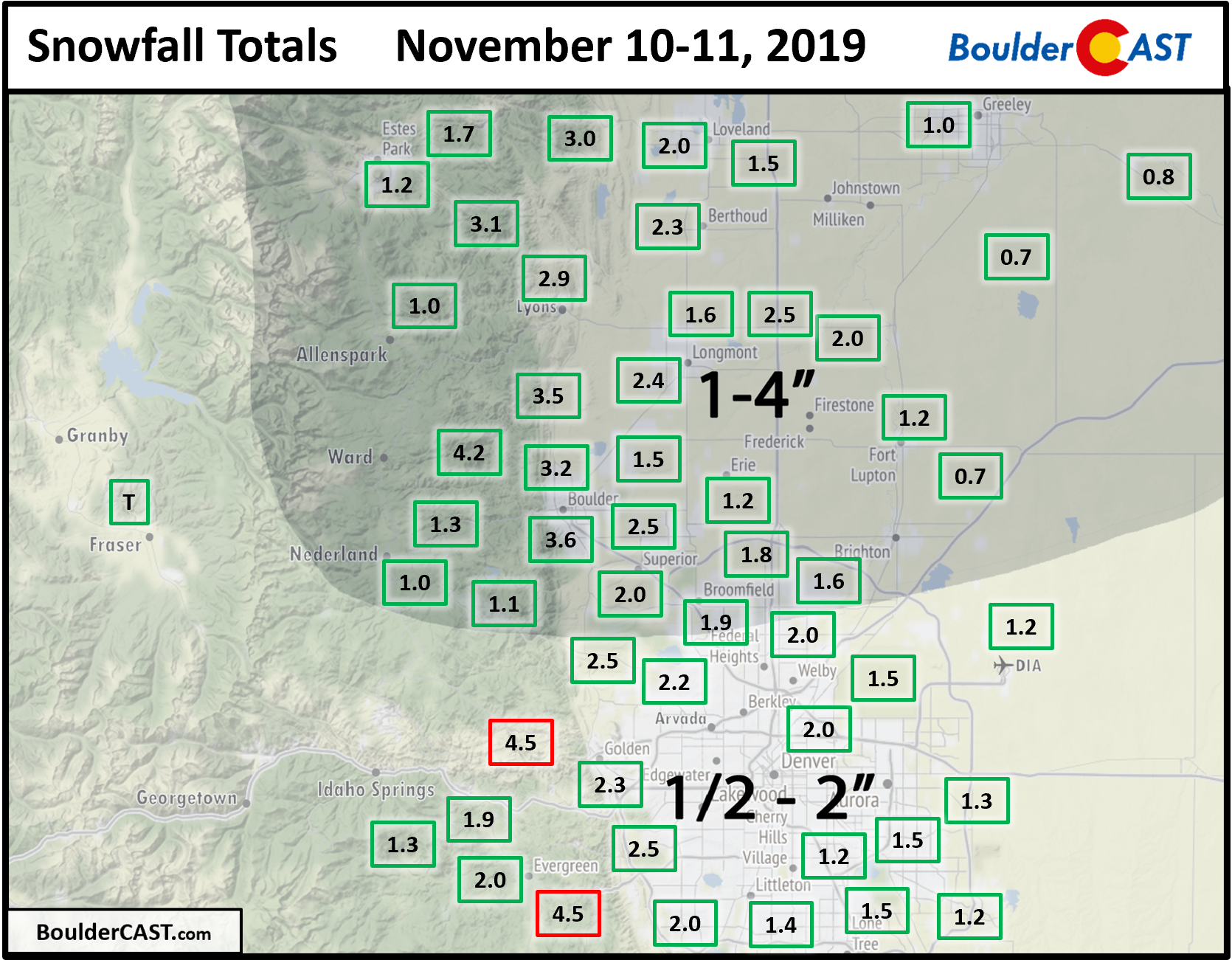
Our forecast did well just about everywhere with a variation in totals of 1 to 4″ region-wide. The trickiest part of the forecast in our opinion was pinpointing exactly how much snow would fall in the localized heavier snow bands from the overhead jet. With the potential for elevated totals from these bands and generous 20:1 snow ratios (or higher) boosting things along, we erred on the side of caution with a 1-4″ range for the northern Metro area where we believed the banding would be most prolific.
Boulder’s official snow total was 3.5″. The snow table at CU Boulder was donning just shy of 4″ when the snow came to an conclusion late Monday morning (see below). We apologize for the blurriness; the lens was coated in a layer of ice from the freezing drizzle that preceded the snow!
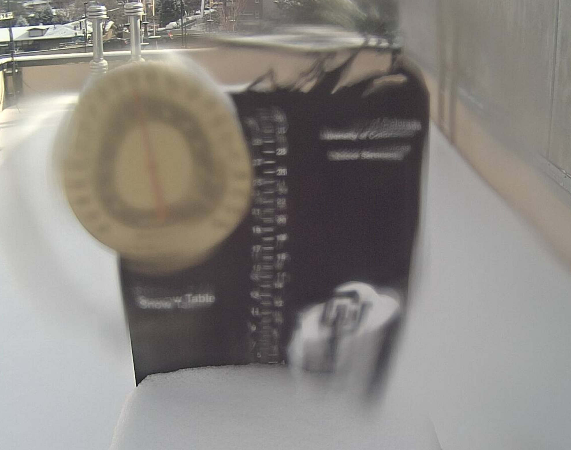
Snow table at CU-Boulder on Wednesday morning showing just shy of 4″ of snow.
The highest totals in the Metro area were between 4.0 and 4.5″ in the lower Foothills of Boulder and Jefferson Counties. Denver officially reported 1.2″ (meh).
In the end, we should consider ourselves lucky for whatever snowfall we got this time around. It was way more than we really should have!
| Seasonal Snow Totals (Updated Nov 12 2019) |
|---|
| Boulder | Denver |
|---|---|
| 29.9" | 13.7" |
Mountain snowpack is looking healthy across the northern Colorado as well. Statewide, snowpack is at 130% of normal for mid-November with only the San Juans struggling so far in this young water year.

An up and down weather week ahead
Following a shockingly cold Monday, temperatures will rebound nicely for our Tuesday. West-northwesterly downslope flow will help to evict the fringe of the Arctic airmass that oozed into eastern Colorado just 36 hours ago. When is the last time a day in the 20’s was preceded AND followed by 60-degree outings? We can’t remember either, but that just may be the case with highs expected to return to the upper 50’s to near 60 degrees in Denver and Boulder today.

NAM 800 mb temperature and wind forecast maps from Monday (left) and Tuesday (right). Notice the major shift in airmass across eastern Colorado!
Looking bigger picture via the GFS 500 mb height anomaly map below for Tuesday, we see that the aforementioned Arctic low and deep trough now encompass the entire eastern half of the United States, including Florida! A ridge of high pressure is located across California with an influence stretching into Colorado today.

GFS 500 mb height anomaly forecast map for Tuesday evening. A weak wave will be entering the northern Rockies
However, riding along the crest of the ridge in the northwest flow is another weak disturbance. Mother Nature just won’t quit! All of the energy from this passing wave will stay to our north in Wyoming with dry downslope flow across the Front Range. The Metro area will remain dry but trend slightly cooler behind the passage of a morning cold front. Correspondingly, temperatures will top only out in the low to middle 50’s on Wednesday. It could also be a little breezy in the afternoon.
Thursday and Friday the weather will remain tranquil across the region. The ridge that was over California on Tuesday shifts eastward and will rest directly over Colorado to end the week. Expect mild to warm temperatures and dry conditions both days. We could even hit 70 degrees come Friday!

GFS 500 mb height anomaly map for Friday morning
Our next chance of precipitation comes Saturday as trough of Pacific origins moves across the Rockies. Models are not in great agreement on this feature just yet. We think there will be a good chance of light snow in the Mountains and potentially a rain/snow mix down across the lower elevations. Unlike our last several storms, this one won’t be Arctic in-nature and thus will be packing warmer air and more moisture. We’ll likely need to watch snow levels with this storm.

GFS model-derived snow levels (left) and snow amounts (right) for Saturday
What ultimately transpires will need to be ironed out in the coming days. For now, expect a cool-down on Saturday with a chance of rain/snow showers and dropping temperatures. The morning could end up being quite mild, though. The best odds of snow accumulation will be in the Foothills and Mountains as temperatures will be borderline across the Plains…

Forecast Specifics:
Tuesday: Sunny with welcomed warm-up. Highs in the upper 50’s on the Plains and middle 40’s for the Foothills.
Wednesday: Partly to mostly sunny, dry and cooler following the passage of a morning cold front. Highs in the 50’s will occur in the morning with steady or slowly falling temperatures the rest of the day.
Thursday: Morning sun and then increasing wave clouds late in the day. Mild with highs in the middle to upper 50’s on the Plains and low 40’s in the Foothills.
Friday: Partly to mostly cloudy and quite warm. Highs near 70 degrees on the Plains and upper 50’s in the Foothills.
Saturday: Partly to mostly cloudy and cooler with a chance of rain and snow showers. Morning highs near 60 on the Plains and near 50 in the Foothills, falling after a cold frontal passage. Light snow accumulations are possible, with higher odds across the Foothills.

High Country: Another week, another bleak outlook for powder in the Mountains. A light dusting of snow is possible Wednesday north of I-70. The storm system system on Saturday offers a better chance of more widespread snow, but don’t expect much (maybe 2-5″). Check our PowderCAST page for always-updated weather forecasts for all of Colorado ski resorts.

DISCLAIMER: This weekly outlook forecast is created Tuesday morning and covers the entire upcoming week. Accuracy will decrease as the week progresses as this post is NOT updated. To receive daily updated forecasts from our team, subscribe to BoulderCAST Premium.

.
Spread the word, share our forecast!


You must be logged in to post a comment.