Just as forecast, the overhead jet stream delivered heavy banded snowfall to the Boulder area Monday evening. We review the evolution of the storm and discuss the snow totals from across the region.
WOW!
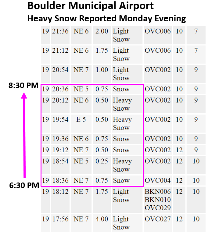
Freezing fog and mist switched-over to all snow after midnight Sunday night, with snow continuing for around 24 straight hours in many locations. Snow was generally light until the early evening hours on Monday when the jet streak entered the picture. A slow-moving snow band with rates of 2″ per hour overtook the city and surrounding area from 6:00 PM to 9:00 PM Monday evening. The timeline of observations from Boulder Municipal Airport last night shows visibility dropping to one-quarter mile at times.
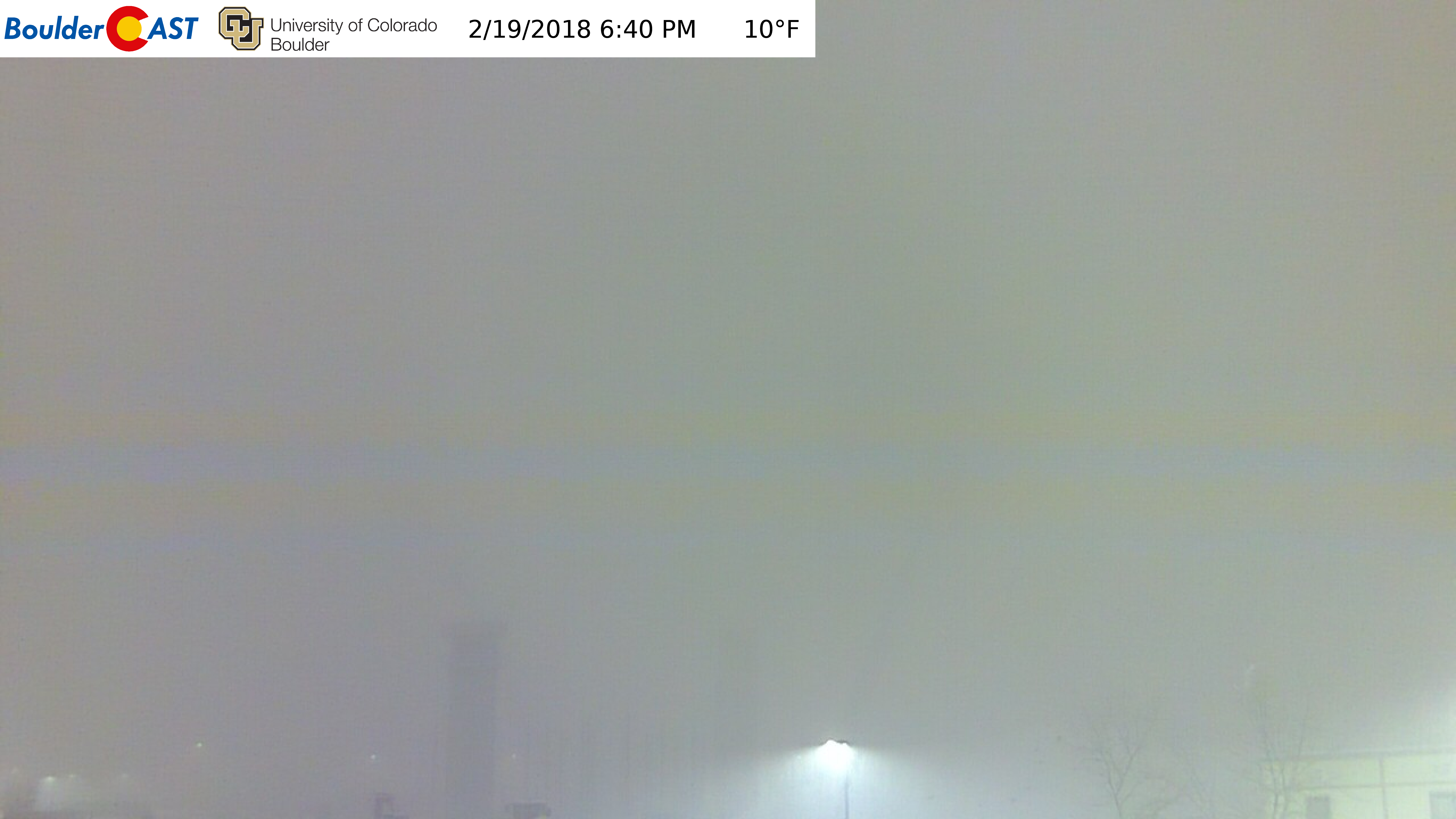
Here’s the view from our camera at 6:40 PM Monday evening. Not much of a view actually….
The last time snowfall of this intensity hit Boulder was more than two years ago on Groundhog’s Day 2016. Back then, we measured 3″ per hour consecutively for several hours at BoulderCAST Station. The forcing for that particular snow band was not the jet stream, but instead, a rare stationary low-level convergence line.
As the heavy snow was falling, temperatures were in the single digits. It is quite uncommon for surface temperatures that cold to coexist simultaneously with heavy snow. The reason is two fold:
- Very cold air has exponentially less moisture content than “normal” cold air
- Once the atmosphere gets too cold, dendritic (big fluffy) snowflakes are not able to form. Instead, the favored snow crystals are tiny flakes.
In the case of Monday evening, deep vertical motion induced by the jet and trough were enough to tap into much warmer, moisture-rich air 10,000 to 15,000 feet above ground level. This created a rare occurrence of heavy snow falling from above into a unquestionably frigid cold airmass at the surface. A few commenters on our Reddit forecast noticed two things resulting from this overlap while driving:
- Person #1: Heavy snow was melting on the windshield, but then refreezing on the wipers before it could be swept away. Every so often, they needed to pull-over and chisel ice from the wipers.
- Person #2: Heavy snow was falling, but the windshield wasn’t even warm enough to melt it. This resulted in no need to even use the wipers, as the snow just blew away while driving.
Person #1 probably had their car very warm, enough to melt the snow, but not enough to keep it from refreezing as it was whisked away. It was just that cold! Person #2 probably didn’t have the temperature warm enough in the car to melt the snow at all. Considering the super-fluffy snow ratios, there is no chance it would be sticking to the windshield, so it just blew past. Neat stuff!
The models nailed it!
The weather models truly did a great job predicting the heavy snow. Shown below of the left is the simulated radar reflectivity from the HRRR model initialized early Monday morning. This is what the model predicted to be happening at 6:00 PM Monday…12 hours in advance. Shown below on the right was the actual observed radar reflectivity at 6:00 PM. The exact placement is never going to be perfect, but the model nailed the general area, intensity, shape, length, and movement of the bands shockingly well. Bravo, HRRR!
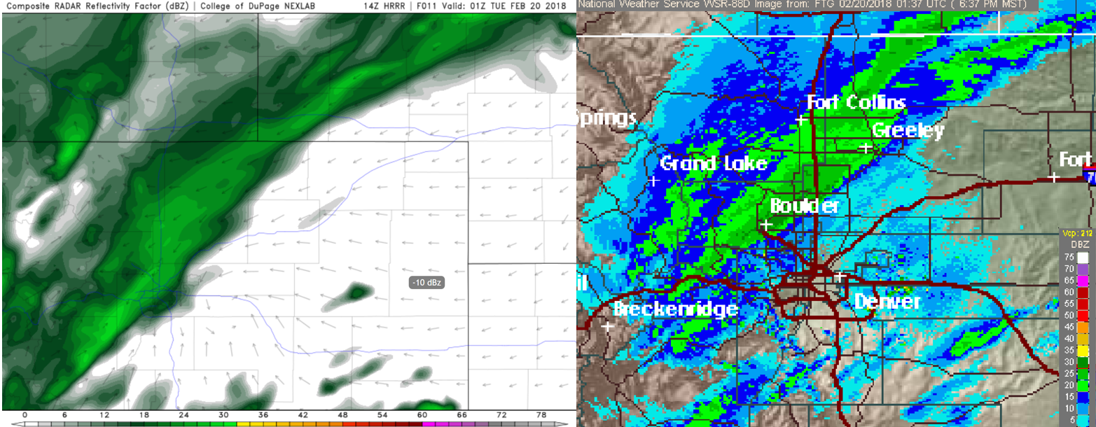
HRRR model simulated reflectivity (left) and actual observed radar reflectivity (right) for Monday evening at 6:00 PM.
The NAM (shown below) and GFS models also predicted a very similar banding structure, stretching from central Colorado all the way yonder into South Dakota.
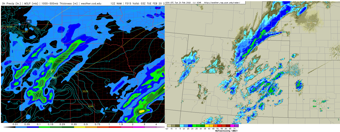
NAM model precipitation forecast (left) and actual observed radar reflectivity (right) for Monday evening.
It was ultimately the close-knit agreement between the various weather models that increased our confidence enough to push our forecasted snow totals higher than anyone else was predicting. It’s perplexing to us that the National Weather Service didn’t at least include Boulder, Broomfield and Longmont in the Winter Weather Advisory. In fact, both Advisory AND Warning criteria were met Monday evening…
- A Winter Weather Advisory is issued when general snow accumulations are expected between 3 and 6 inches in 12 hours.
- A Winter Storm Warning is issued when general snow accumulations are expected to exceed 6 inches in 12 hours or 8 inches in 24 hours.
Boulder’s official snow total was 8.8″ from the storm. About 6″ of this fell between 5:00 and 9:00 PM Monday evening. This brings our February snow total in Boulder to 16″. This is about 2″ above normal for the month, something that puts a wrench into our 3-Month Snowfall Forecast Contest. Denver reported a respectable 2.9″ through the day Monday.
Shown below is our original snowfall forecast map (issued Monday morning), with the observed storm totals per location contained in boxes. Green ones indicate that the observed snowfall was within one inch of the given forecast range, while red was outside the scope of our forecast.
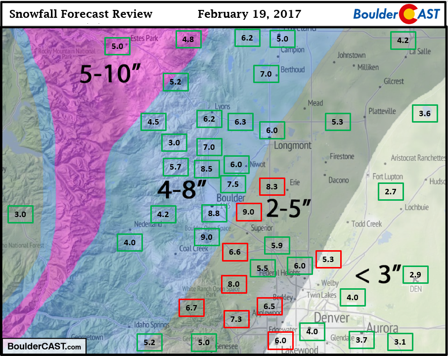
Many areas experienced their biggest snow of the season, and in the case of Longmont, the biggest in more than two years! Snow totals were highest in areas impacted by the heavier bands the longest (6 to 9″), mainly in eastern Boulder County. Lowest amounts were in the eastern and southern portions of the Metro area (2 to 4″). Right after creating this forecast map, we almost immediately regretted not expanding the 4 – 8″ zone eastward by about 10 miles. That would have made for an almost perfect forecast. However, we tend to avoid any changes unless 100% necessary and certain. As such, some areas southeast of Boulder blew past our 2 – 5″ forecast. But hey, better more than less…right?
Due to the lack of awareness provided by the NWS and the local media, many folks were caught off-guard by the amount and intensity of the snow Monday evening. Not you, of course, but those “other” folks were. Nonetheless, lingering impacts from the storm appear to be minimal. Roadways are already in good shape, thanks in part to sunshine and very warm temperatures near 70 degrees we had on Sunday.
One failed aspect of the storm by the models was the clearing skies Tuesday morning. With fresh snow and Arctic air in place, as soon as the clouds dissipated overnight, which was not predicted well by the models, temperatures plummeted below zero across the Plains, producing our coldest temperatures of the year thus far rather unexpectedly. Boulder set a new record low for February 20th at -6 degrees. Denver hit -3 degrees (not a record). Though skies will be clearing again tonight, we’re not expecting temperatures to be quite as cold as last night. Look for temperatures somewhere between 0 and 5 degrees ABOVE zero Wednesday morning.
It will take several days to dig ourselves our of the very cold and very dark hole that we are currently in. The GFS ensemble forecast below for the Denver Metro Area shows the slow climb back to near-normal temperatures by MAYBE early next week.
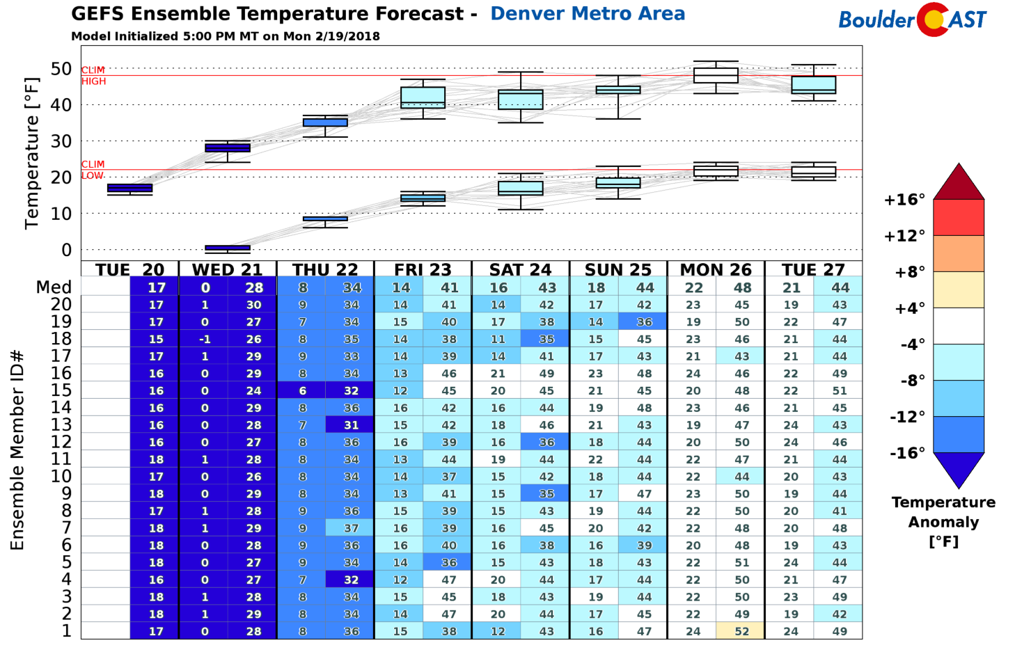
The GFS and European ensembles persist deep troughing across the western United States through the end of February. This should keep things on the cool side for us, with frequent chances for snow, especially in the Mountains. Great news for the skiers…for once.
In the meantime, enjoy the snow! It won’t be melting all that soon…
Share this storm recap & let us know your snow total in the comments:
.


You must be logged in to post a comment.