Congratulations to the World Champion Denver Broncos! Weather was definitely not a factor during the game, which is how the NFL’s championship should be played! Let the better team win without any of Mother Nature’s shenanigans.
On that note, that beautiful California weather will spread east to include Colorado this week. We really couldn’t have hand-picked two consecutive, polar-opposite weeks of weather if we tried. Just seven days ago, we were in winter weather forecast mode, with more than a foot of snow knocking on the door. This week, our discussion focuses on a significant warming pattern as a ridge builds across the West. Read on to find out if and when we will have a chance for record heat.
Dry, warm, and boring
After weeks (months!) of storm after storm coming ashore in California and eventually bringing snow to the Mountains and Plains of Colorado, the pattern is going to quiet down. We first mentioned a likely pattern shift late last week, as ensemble guidance indicated a large upper-level blocking ridge would form over the western United States. This is still the case, with both the ECMWF and GFS ensembles holding the ridge mostly in place through next week (mid February, at least). Shown below is the 10-day forecast for 500mb height from the Euro ensemble. Areas denoted in orange are above normal heights (ridging/warming), while those in blue are below normal heights (troughing/cooling).
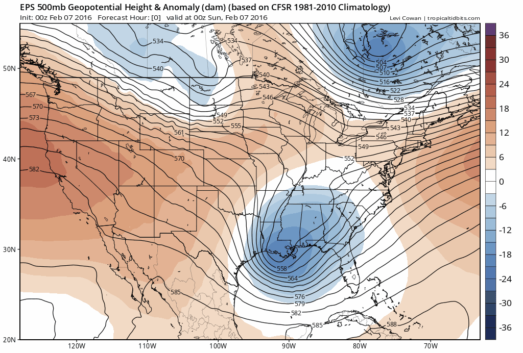
Notice how the West remains mostly in the orange, while the East Coast is largely blue. This “blocking” ridge will essentially prevent Pacific storm systems from coming ashore in California, pushing them northward into Western Canada. This will mean dry and warm weather for much of the western US, including Colorado, while it is in place. However, these types of ridges do not persist easily in the heart of winter. A few weak systems can still make it through, which we do see in the ensemble loop above. In fact, it’s actually these times when the ridge looses some amplitude that the warmest weather can then push into Colorado. You can see the warming in the loop below of surface temperature anomaly from the GFS ensemble. Notice how the heat persists across the West, with cold air sinking into the eastern USA.

The melt is on
Okay, time for the specifics of this week’s forecast. We’ll try to keep it brief. As we have alluded to, there really isn’t that much exciting weather going on, unless you enjoy warmer weather.
On Monday, the ridge axis will be parked over California/Nevada, with north-northwesterly flow over Colorado, in the transition zone between the western ridge and eastern trough. Not much changes through Thursday. Shown below is the 500 mb forecast map for Monday (left) and Thursday (right) from the GFS.
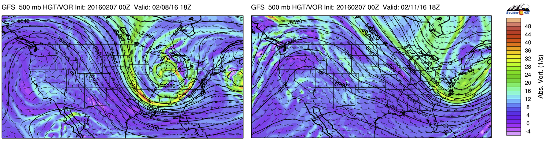
GFS 500mb vorticity map for Monday (left) and Thursday (right). The ridge remains locked over the West with little movement over the next three days
The air under the ridge is quite dry, so despite the strong northwesterly flow, we won’t even see snow showers in the High Country through the week, with mostly sunny skies across all of Colorado!
There is a very subtle kink in the heights over Colorado on Thursday (seen in right image above). This is an extremely weak system that will bring a cold front through NE Colorado on Thursday morning, which will only serve to drop our temperatures a few degrees (no precipitation, and barely any cloud increase).
The GFS total precipitation through Saturday sums up just how dry we will be.
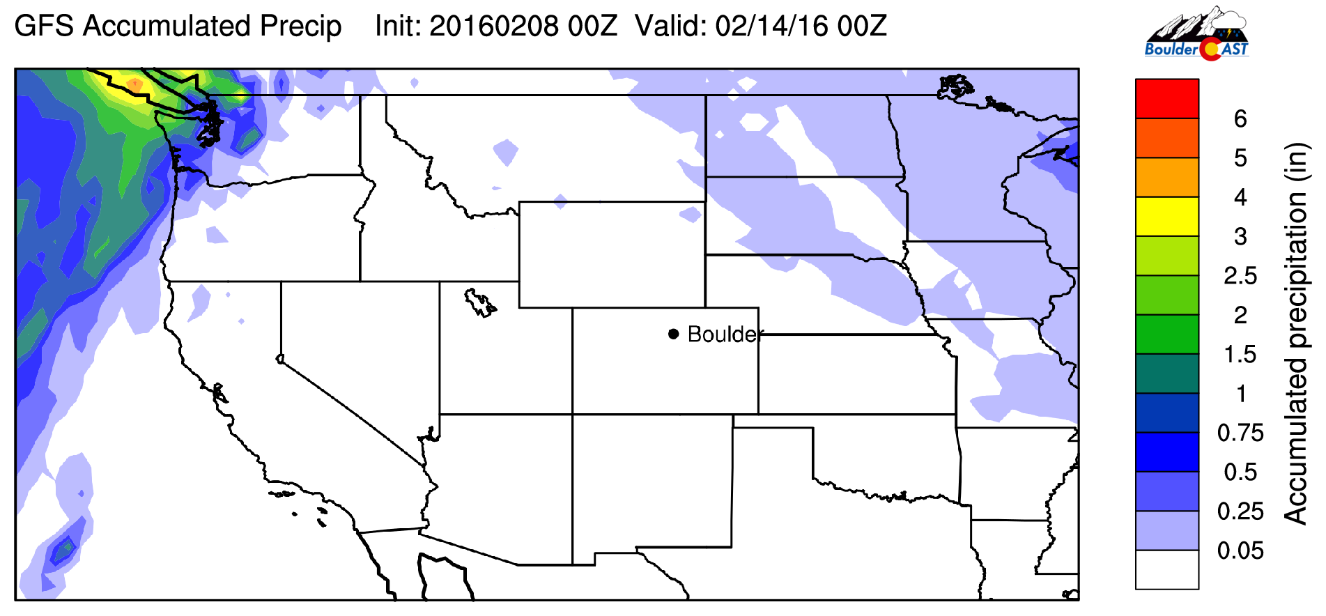
GFS forecast total accumulated precipitation through Saturday evening. High and dry for all as moisture and weather gets pushed northward into British Columbia.
Temperatures will moderate from upper 40’s on Monday, to upper 50’s on Tuesday, to 60’s on Wednesday, dropping back down a few degrees for Thursday and Friday. Our warmest day, with a small chance to hit the elusive 70-degree mark, will likely be Wednesday ahead of Thursday’s cold front. The record high in Boulder for the date is 72 degrees, which may be a little out of reach. Though, with this weather pattern in place, we at least have a shot! The models may just not be grasping the extent of the warm air. They have generally been low-balling forecasts on similar days over the last several weeks.
The first hint in the models of a cool down and maybe even precipitation for our region (probably only northern mountains) isn’t until Sunday or (next) Monday when a weak system rides along the apex of the ridge through Wyoming. We’re not convinced on that one yet. Long-range model guidance from the CFSv2 suggests this ridge will anchor across the West (in some form) for the next two weeks or more. While the chances of much happening under this pattern are low, the sub-tropical jet can sneak up beneath the ridge, which could amplify the situation if something does materialize. This is nothing more than a “what if” for now, though.
The CPC agrees in their outlook for the third week of February…
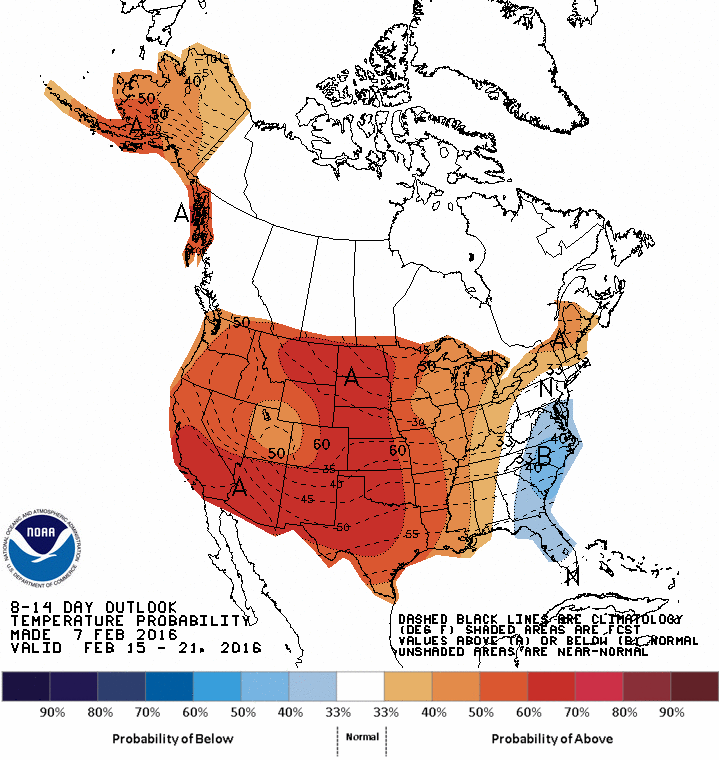
8 to 14 day temperature outlook from the CPC (Feb 15-21, 2016). Warmer than average temps likely across most of the country.
Enjoy the early spring thaw and have a great week!
The Forecast:
Monday: Some high clouds. Breezy at times, mostly in and near the Foothills. Highs in the mid 40’s on the Plains, with upper 30’s in the Foothills.
Tuesday: Mostly sunny and mild. Highs in the upper 50’s across the Plains, with mid 40’s in the Foothills.
Wednesday: Sunny and warm. Highs in the mid 60’s on the Plains, with mid 50’s in the Foothills.
Thursday: Mostly sunny and mild. Highs in the upper 50’s on the Plains, with low 50’s in the Foothills.
Friday: Mostly sunny and mild . Highs in the upper 50’s on the Plains, with low 50’s in the Foothills.
High Country Forecast: Gusty northwest winds for Monday and Tuesday. Warm with plenty of sunshine throughout the week. No real chance of snow until early next week.
| Source | Mon | Tue | Wed | Thu | Fri |
|---|---|---|---|---|---|
| BoulderCAST | 46 | 59 | 64 | 58 | 58 |
| NWS | 50 | 58 | 64 | 59 | 58 |
| AccuWeather | 51 | 55 | 59 | 57 | 55 |
| The Weather Channel | 44 | 49 | 59 | 58 | 56 |
.
Last week’s recap:
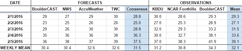
Here are the results of last week’s forecast. First, the forecasts and observations from all of the sources:
Last week began with a snow storm with cool weather continuing through the week. We forecasted 10-16″ of snow for Boulder (6-12″ in Denver) Sunday night into Tuesday morning. Boulder officially picked up 16.8″ of snow (11.3″ in Denver). Be sure to catch up on the details in our recap post. We also discussed why we were able to forecast the system so well in advance in a different post.
Let’s look at the error analysis. Shown below is the amount of degrees (in Fahrenheit) that each source was off from the mean observed temperature for Boulder. Positive values indicate the forecast was warmer than what actually occurred, while negative values arise from a forecast that was cooler than what was observed.

Overall a great week. Mean errors were below 3 degrees every day. That doesn’t happen too often! The worst forecast day was Wednesday, with temperatures warming several degrees above the forecast. Truth be told, the cold air behind the system was meager at best. Definitely not as cold as it could have been. The coldest day of the week had a high of 27 degrees, rather modest. The models definitely overdid the cold air, but just slightly. It was more about the persistent chill.
The bottom row of the error table shows the weekly mean error for each weather outlet, a good measure for who was the best and more consistent “forecaster” for the week. The winner this week is AccuWeather, just edging out the Weather Channel. Admittedly, we focused much more on the early week snowstorm than temperatures through the period. We hope to return to first place next week!


