It is clear Mother Nature wants to make this year’s Mother’s Day weekend one to remember. From flooding rains, to severe storms, and snow, this weekend will have it all! With the upper-level low about to enter Colorado, the picture the models are painting is now coming into focus. Read on to find out the impacts for your area.
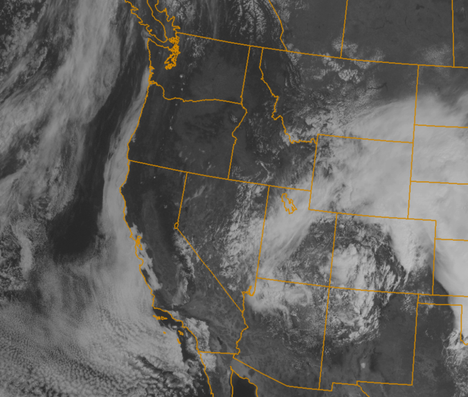
The upper-level low pressure system responsible for our recent turmoil is currently located over northeast Arizona (notice the swirl in the visible satellite image above). It will quickly approach and pass almost directly over Denver by 3am Sunday. Gulf moisture has been streaming into eastern Colorado over the last several days. With the approach of the system, small shortwave features have been pulsing through Boulder County, producing on-and-off bouts of rain over the last 48 hours, which has been heavy at times. The eastern half of the county was under a flood warning last night, with both the St. Vrain and Boulder Creeks about to overflow their banks. Check out some of the 48-hour rainfall totals from around the county (ending at 7am Saturday):
- Longmont – 2.72″
- Erie – 2.70″
- Marshall – 2.17″
- Nederland – 2.14″
- Allenspark – 1.77″
- Boulder – 1.72″
- Louisville – 1.44″
With amounts in the 1.5 to 3.0″ range already, and significant precipitation still to come, flood concerns will remain elevated through the weekend.
If you caught our last forecast, issued on Thursday, you are well informed. The biggest fine-tuning comes to the winter portion of the storm. The uncertainty all along was in regards to how much overlap there would be between the cold air and the heavier precipitation. It now appears that atmospheric profiles capable of supporting snow on the Plains/lower Foothills will develop around 9pm (previous thought was around midnight). Furthermore, the timing of the heaviest precipitation will persist longer than originally expected. This is a result of a slightly more southerly track to the system which the models are now coming into agreement on (see below). The change is quite subtle, but it will provide prolonged, 25-35kt northeasterly upslope flow at 700mb to Boulder County through 6am, which is a fairly efficient direction. Adding in precipitable water around 0.65″, strong upper-level forcing, the night timing, and the cold air, we could be in for a decent late-season snow storm once again!

The GFS 700mb forecasts for wind, heights, and temperature, valid at 9pm Saturday. The image on the left is Thursday morning’s run, while the image on the right is Saturday mornings. Very similar overall, but the subtle difference in storm location (further south on right) and temperature (slightly cooler for Boulder on right) will have big implications.
In Summary:
A Flood Warning remains in effect through 9pm this evening for the lower elevations of Boulder County. Minor flooding has already been reported, and will likely get worse this evening.
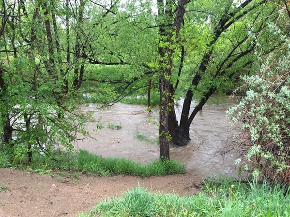
Current view of Bear Creek in South Boulder, approaching flood stage
Saturday afternoon will be somewhat calm early on, as Boulder now sits in a small “dry slot.” However, heavy precipitation along a convergence line east of Denver will slowly push westward through the afternoon. We may even see some breaks of sun early on, but this will only destabilize things for further redevelopment. As the upper-low approaches, strong cyclogenesis will form and rapidly intensify the surface low in SE Colorado, and along with it, the upslope to our region this evening.
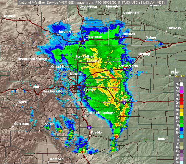
Current radar for Denver at noon Saturday.
Temperatures will climb into the mid 50s this afternoon, before falling through the 40s and into the 30s early this evening. Rain will fully change over to snow sometime between 8pm and 11pm this evening on the Plains, and slightly earlier in the lower Foothills. Snow levels, which are currently around 8,500 feet, will rise slightly during the early afternoon, then plummet as the upper-low approaches later this afternoon. Snow will continue through mid-morning Sunday, before the departing storm system caters downslope winds, and the snow tapers off. The heaviest snow is likely to fall between 11pm and 4am overnight, when strong NE upslope winds are most favorable and the surface low is nearby. However, the exact location of the heaviest bands is still somewhat uncertain. The GFS model brings the heaviest snow into Boulder County overnight.
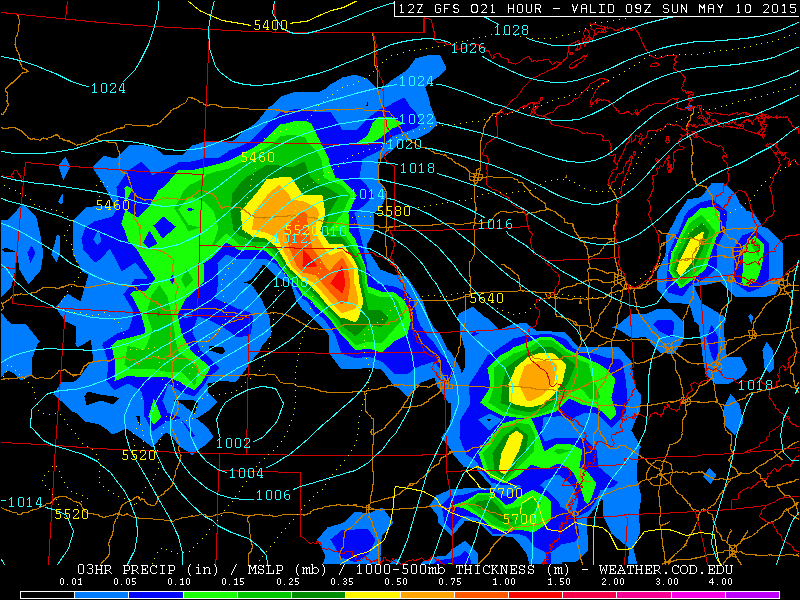
GFS model forecast for precipitation and pressure at the surface, valid at 3am Sunday. Notice the position of the developing low in SE Colorado and the heavy precipitation (snow!) banked up against the Foothills in our region.
Snowfall totals by noon Sunday will be:
- Plains: 4 to 8″
- Foothills below 8000 feet: 5 to 12″
- Foothills between 8000 and 10,000 feet: 8 to 14″
- Mountains above 10,000 feet: 10 to 16″

SREF (Short Range Ensemble Forecast) plumes for total snow in Boulder. Most ensemble members predict 5-10″ of snow. However, they have a decent chunk of that falling before 9pm (predicted change over time to snow), so totals will likely be a tad less.
Lower elevation snow will be heavy and wet. Foliage on the Plains is quite advanced at this point, so downed tree limbs and power lines is likely given the snow’s night-time arrival. Frost and potentially freeze warnings are likely in order Monday morning for the lower elevations as well. What a time to be alive, right?
Be sure to follow BoulderCAST on Twitter for frequent storm updates and to subscribe to the site to get these posts delivered to your email box (enter your email in the sidebar widget to right)!
—–
We did mention severe weather for today as well, but that threat will remain well to the east of Boulder County, near the Kansas/Colorado border. There is a very good chance of tornadoes and large hail, stretching as far east as the southern and eastern suburbs of Denver. Check out the Storm Predictions Center’s outlook for today.

SPC Severe Weather Outlook for Saturday. Eastern Colorado will be one of the focal points for tornadoes and large hail later this afternoon.


