Soggy conditions have lingered across the Front Range for more than a week now, bringing measurable precipitation to most of Boulder County each day in May. This trend will continue through the weekend, as we track a developing surface low that will bring the possibility of accumulating snow on the Plains Saturday night into Mother’s Day.
A large, upper-level trough, currently located over Oregon, will sag south and then slide eastward into Colorado on Saturday. Ahead of the trough’s arrival, flow into our region will be from the south, which will keep the air mass very moist, setting the table for a good chance of scattered showers and thunderstorms each day. Weak upslope flow during the day Thursday will be reinforced with the passage of a weak cold front Thursday night. This will enhance the precipitation on Friday and lower temperatures about 5 to 10 degrees, with highs Friday/Saturday barely climbing into the low 50s on the Plains and 40s in the Foothills.
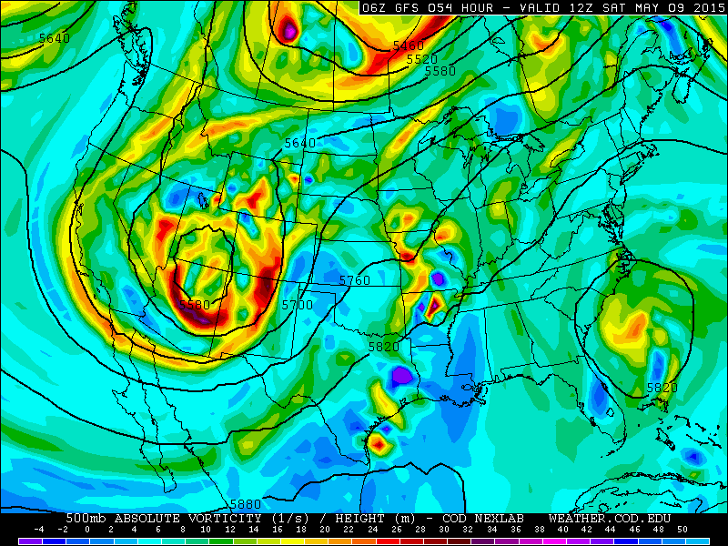
500mb height map with vorticity from the GFS for Saturday morning, showing the position of the upper-level low near the Four Corners. Over Colorado, strong vorticity advection will spawn a surface low.
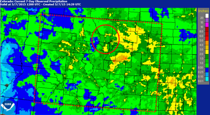
Model QPF (Quantitative Precipitation Forecast) through Sunday evening shows the Plains and Foothills picking up 1.0 to 2.0″ of precipitation, with up to 3.0″ in the highest elevations. However, with the moist and at times, marginally unstable air mass in place, some spots could receive locally heavier amounts. While rain is (almost) always welcome in our state, portions of NE Colorado have received more than 4.0″ of rain over the past week, which has led to some minor flooding in Denver. Continued rain on near-saturated soil will keep the flood risk elevated through the weekend.

Following a period of heavy rain, the Platte overflowed its banks in Denver on Tuesday
As the upper-level low makes its final approach on Colorado, a surface low will develop near Pueblo and intensify as it moves northward towards Nebraska (see below). This will provide Boulder County with intensified, deep upslope, initially southeasterly around noon Saturday, shifting to easterly and eventually northeasterly by 9pm. Once this northward component to the upslope commences, colder air will advect down into NE Colorado in the lower atmosphere.
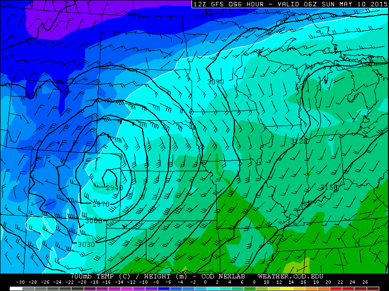
700mb map with temperature valid at 12am Sunday from the GFS. A still NNE 35 knot upslope is indicated for Boulder, with a sub-freezing 700mb temp to support snowfall.
The two most important factors that will determine how much snow everyone gets:
- Track: This is key. Current runs of the GFS and NAM models both depict a relatively unfavorable track for sustaining much lower elevation snowfall in Boulder County. 700mb winds shift to straight northerly and quickly to northwesterly before sunrise on Sunday. This shift towards downslope will limit the potential of this system. However, moisture will be high with precipitable water values ranging from 0.5 to 0.8″ through sunrise, so this may act as a bit of a buffer. Additionally, a slight change in track could shift the heaviest snow from its currently forecasted location (in southern Wyoming/western Nebraska) southward towards our region, but this seems unlikely for now.
- Cold air: Given the current track, appreciable snow for the Plains will depend most critically on the timing of the arrival of the cold air, which will not happen until the very tail-end of the event. Model soundings indicate the air column will not be able to support snow on the Plains until sometime around midnight Saturday night.
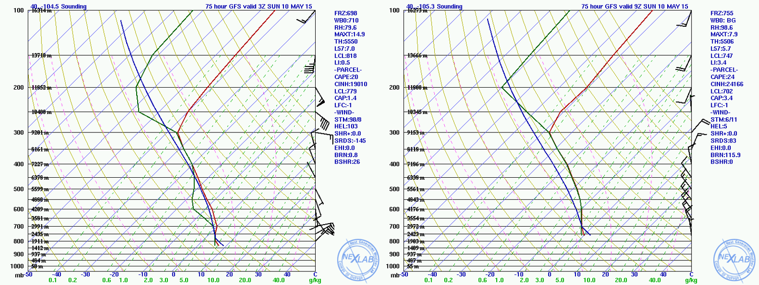
Forecast soundings from the GFS for Boulder valid at 9pm Saturday (on the left) and 3am Sunday (on the right). 9pm sounding supports snow levels near 8k feet, but by 3am, snow will encompass the Plains
The forecast:
At this time, it looks like Boulder County is in store for 1-3″ of liquid by Sunday afternoon, with everyone on track for snow at some point this weekend! Snow levels will be holding steady between 9,500 and 11,000ft through Friday. Friday night, snow levels may fall as low as 8,500 feet, but accumulations will be light. A large swath of precipitation will develop and move northward on the backside of the intensifying surface low Saturday. Beginning Saturday morning, cold air aloft associated with the trough will infiltrate the state, lowering snow levels to encompass the higher Foothills. In the late afternoon, a surface cold front will push southward into Colorado. Temperatures on the Plains will fall through the 40s, and eventually into to the low to mid 30s to support snowfall by midnight. Winds will quickly become NNW around 6am Sunday, brining an end to the snow by late morning.
This year will be Boulder County’s second consecutive white Mother’s Day. In 2014, Boulder recorded 7.1″ of snow, while the Foothills got dumped with 1 to 2 feet!
So what can you expect in the way of snowfall totals this Mother’s Day? For areas above 8,000 feet – 8 to 16″. Between 6,000 and 8,000ft – 3 to 8″. With only a few hours of overlap between the cold air and upslope, 1 to 4″ on the Plains seems reasonable at this point. However, some of the models (Euro/Canadian) bring more than a foot of snow to the entire Denver metro area. This seems totally unreasonable given the unfavorable track/wind direction and the mid-May timeframe, but does bear watching.
Sunday will see the snow taper off and maybe even a few peaks of sunshine. Sunday night into Monday morning bears close watching as well, but not for the threat of snow. With skies potentially clearing in the wake of the storm system, all of Boulder County will be at risk to drop below freezing, likely into the mid-20s in spots.
We will continue to evaluate this storm over the next few days, so stay tuned to BoulderCAST!


You must be logged in to post a comment.