As the heatwave reaches peak intensity on Wednesday, Boulder is well-positioned to obliterate the existing daily record high temperature for the date, maybe even before the lunch hour! However, increasing smoke from distant wildfires, more widespread clouds and outflows from developing showers could keep the city from hitting the elusive century mark. We review the climatology of rare triple digit heat, discuss why Denver is often several degrees warmer than Boulder on days like this, and take a look ahead to when the heat will end.
Help support our team of Front Range weather bloggers by joining BoulderCAST Premium. We talk Boulder and Denver weather every single day. Sign up now to get access to our daily forecast discussions each morning, complete six-day skiing and hiking forecasts powered by machine learning, first-class access to all our Colorado-centric high-resolution weather graphics, bonus storm updates and much more! Or not, we just appreciate your readership!

UPDATE (Fri 6/18/21 7AM): The temperature in Boulder reached 99° on both Wednesday and Thursday this week. While both days set new daily record highs, the city managed to escape triple digits from this heatwave.


nlike Denver, Boulder did not reach the triple digit mark on Tuesday, but this was expected. The official high was only 96°F in the City at the Base of the Flatirons.
The high so far today in Denver has been 101 degrees. This breaks the old record of 97 which occurred in 1952 and 1993. There are still several more hours for it to get even warmer. #cowx
— NWS Boulder (@NWSBoulder) June 15, 2021
It may come as a surprise, but Boulder is almost always cooler than Denver during the summer months, usually by several degrees. There are a few notable reasons for this temperature shortcoming:
- CLOUDS: Summertime cumulus clouds and storms routinely build over Boulder earlier in the day than Denver as they almost always initiate over the higher terrain first and move eastward. This allows Denver to capitalize on more solar heating during the late morning and early afternoon.
- ELEVATION: Boulder is slightly higher in elevation than Denver, which has cooling implications in the daytime. For summer heat, lower elevation is better. Just look at Death Valley!
- TERRAIN PROXIMITY: Boulder’s closeness to the Foothills tends to produce a weak upslope breeze during summer mornings which has a slight cooling effect. As the sun rises to the east, it strikes the eastern slopes of the Foothills/Mountains at the most efficient angle. This creates what is known as a valley breeze which is similar to a sea breeze. Both are created due to differential heating of two nearby locations. It’s not until around midday that the sun rises high enough to reduce the differential heating and kill off the valley breeze.
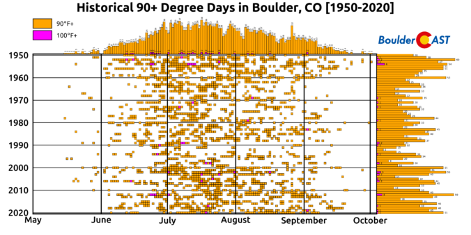
While Denver averages almost one 100-degree day per year, Boulder sees only about one every two years. As shown in the graphic below, there have only been 36 100°+ days in the last 71 years in Boulder. The most common window for triple digit heat is from late June through late July, but they have been known to occur as early as June 12th and as late as September 2nd (twice!).

Click to enlarge!
The ongoing heatwave will maximize on Wednesday for northeast Colorado and this will offer another chance for Boulder to hit the rare triple digit mark. However, we don’t think that’s going to happen…
For one, there is a ton of wildfire smoke trapped underneath the potent Four Corners ridge, including smoke from two new big fires in Montana. Can you pick out the huge clockwise circulation in the smoke concentration forecast below? All those tiny smoke particulates floating in the atmosphere above has a net cooling effect on our surface temperatures as a portion of the sun’s energy is scattered, absorbed and reflected away. Smoke content is much higher on Wednesday compared to any days prior reducing our chances of reaching 100°F.
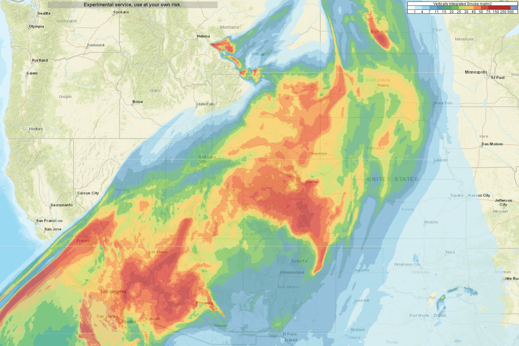
Total smoke forecast animation for Wednesday
Furthermore, though you wouldn’t know it from our temperatures, the ridge parked over the Four Corners is beginning to break down Wednesday and some afternoon high-based convection is expected to return to the Front Range. We’ve had almost uninterrupted sunshine the last few days under high pressure, but that will change on Wednesday as clouds and even a few isolated weak storms develop during the afternoon and evening. Storms won’t produce much rainfall at all, but increasing clouds and gusty cool outflow breezes will help to take the edge off the heat and contribute to lower chances of reaching 100°F.

HRRR cloud cover forecast for Wednesday. Though it will start sunny (and smoky), clouds will increase abruptly through the afternoon and evening.
For these reasons, we expect today’s maximum temperatures to occur earlier in the day, perhaps even by early afternoon, before storm clouds fill the skies and cool outflows start sloshing around. Boulder should land somewhere in the upper 90’s on Wednesday with a small but non-zero chance to touch the century mark.

By the way, a new daily record high temperature in Boulder is all but guaranteed Wednesday as the existing record high is only 94°F for June 16th. Interestingly, this existing record one of the weakest during the entire summer in Boulder and today we will rightly obliterate it. You won’t find an existing record high at or below 94°F again until September 7th! We knew this record was going to be broken nearly a week in advance, which speaks to the intensity of this ridge and also the feebleness of this particular historical record!

Another record high temperature will be possible on Thursday, but it should be a few degrees cooler with even more clouds and a slightly better chance of late-day storms. The end of the heatwave, if you want to call it that, comes Friday morning in the form of a weak “cold” front. Temperatures will fall about ten degrees Friday into the weekend with upper 80’s common and better chances for storms across the Denver Metro area.

A stronger cold front is taking shape late in the weekend or early next week which will cool off much of the central United States and probably eastern Colorado as well. The temperature outlook for next week from the Climate Prediction Center looks promising at least! It’s still quite a ways out in the forecast, but the brightly lit end of tunnel appears to be cooler than where we are right now…

CPC temperature outlook for June 21 (Monday) – June 25 (Friday)
Stay up to date with Colorado weather and get notified of our latest forecasts and storm updates:
We respect your privacy. You can unsubscribe at any time.
Help support our team of Front Range weather bloggers by joining BoulderCAST Premium. We talk Boulder and Denver weather every single day. Sign up now to get access to our daily forecast discussions each morning, complete six-day skiing and hiking forecasts powered by machine learning, first-class access to all our Colorado-centric high-resolution weather graphics, bonus storm updates and much more! Or not, we just appreciate your readership!
.


You must be logged in to post a comment.