The heat is on this week as an anomalous ridge of high pressure dominates our weather pattern. Temperatures will soar into the upper 90’s to low 100’s most of the week, but a cooldown is in the pipeline. Let’s take a look at the outlook for the week ahead, what potential records could be shattered, and when the heatwave is expected to break.
This week’s highlights include:
- A strong ridge of high pressure will dominate our weather through the week producing hot and largely dry conditions
- Temperatures zoom into the middle 90’s to lower 100’s through Thursday
- Dispersed wildfire smoke will be on the increase this week and it will have a slight cooling effect
- A cooldown is expected late in the week as the ridge breaks down
- Very minor storm chances from mid to late week. Most areas will be completely dry, however
DISCLAIMER: This weekly outlook forecast is created Monday morning and covers the entire upcoming week. Accuracy will decrease as the week progresses as this post is NOT updated. To receive daily updated forecasts from our team, subscribe to BoulderCAST Premium.

Flirting with record heat
The next few days will be very hot across all of Colorado as the well-advertised heatwave reaches its peak. This past Sunday was the warmest afternoon yet in 2021 for Boulder at 92°F. We’ll climb even further up the ladder this week with most locations in the Denver Metro area expected to approach the century mark at least one time, if not several!
The culprit for such a strong heatwave is of course a potent ridge of high pressure which has been building northward across the Rockies. The animation below shows the forecasted evolution of this high pressure center through Saturday across the West. This ridge is forecast to strengthen to just shy of 6000 meters at 500 mb at its strongest this week…certainly intense for mid-June, or anytime of year really. Initially the ridge axis pushes well northward into Canada on Monday and Tuesday but flattens out and starts to break down by week’s end. This ridge will be accompanied by widespread sinking motion in the atmosphere and also very warm air aloft. These conditions together tend to greatly suppress convection in the atmosphere and will produce generally clear and dry conditions for most of the Desert Southwest and Colorado to go along with the bubbling heatwave.
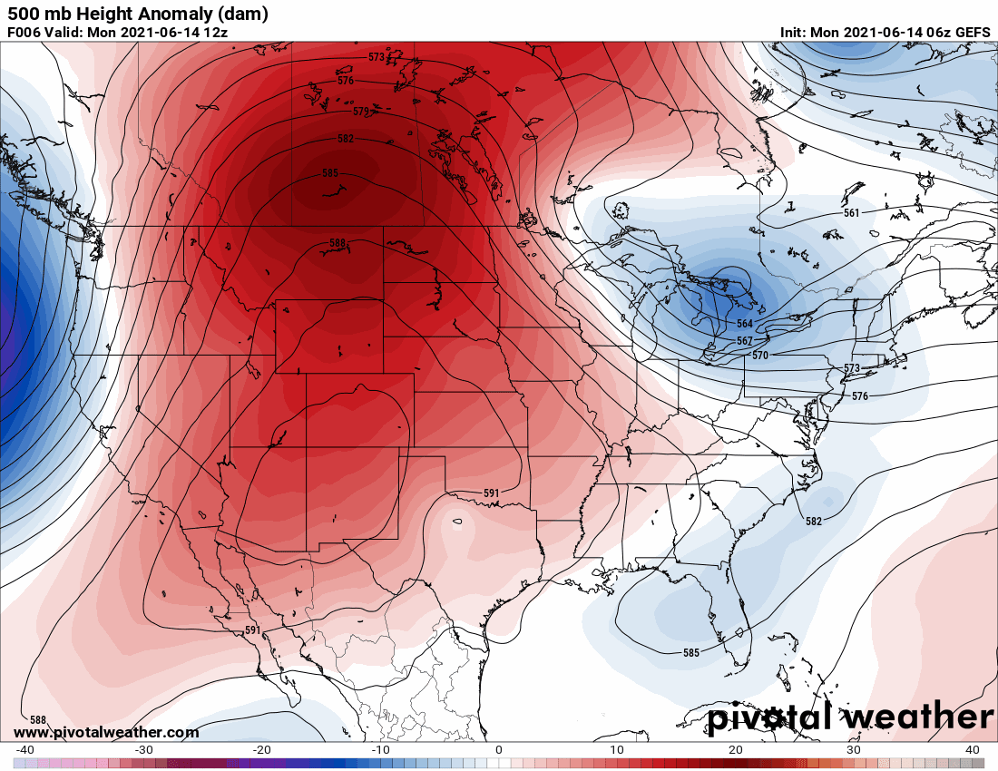
GFS ensemble mean 500mb height anomaly forecast animation spanning the entire week through Saturday. The ridge intensifies across the Four Corners but weakens by late-week
As we discussed in our last forecast update on Friday, while it certainly is going to be very hot this week, the Front Range is not in the prime location of this ridge to cash in on maximum heating. Across northern Colorado, our flow aloft will be out of the northwest which isn’t a direction capable of shattering any all-time records for our area. For reference, the all-time record high temperatures in Boulder and Denver are 104°F and 105°F, respectively. Had the position of the high pressure been slightly further east, southwest flow would be the story and we may have seen those historical values challenged.
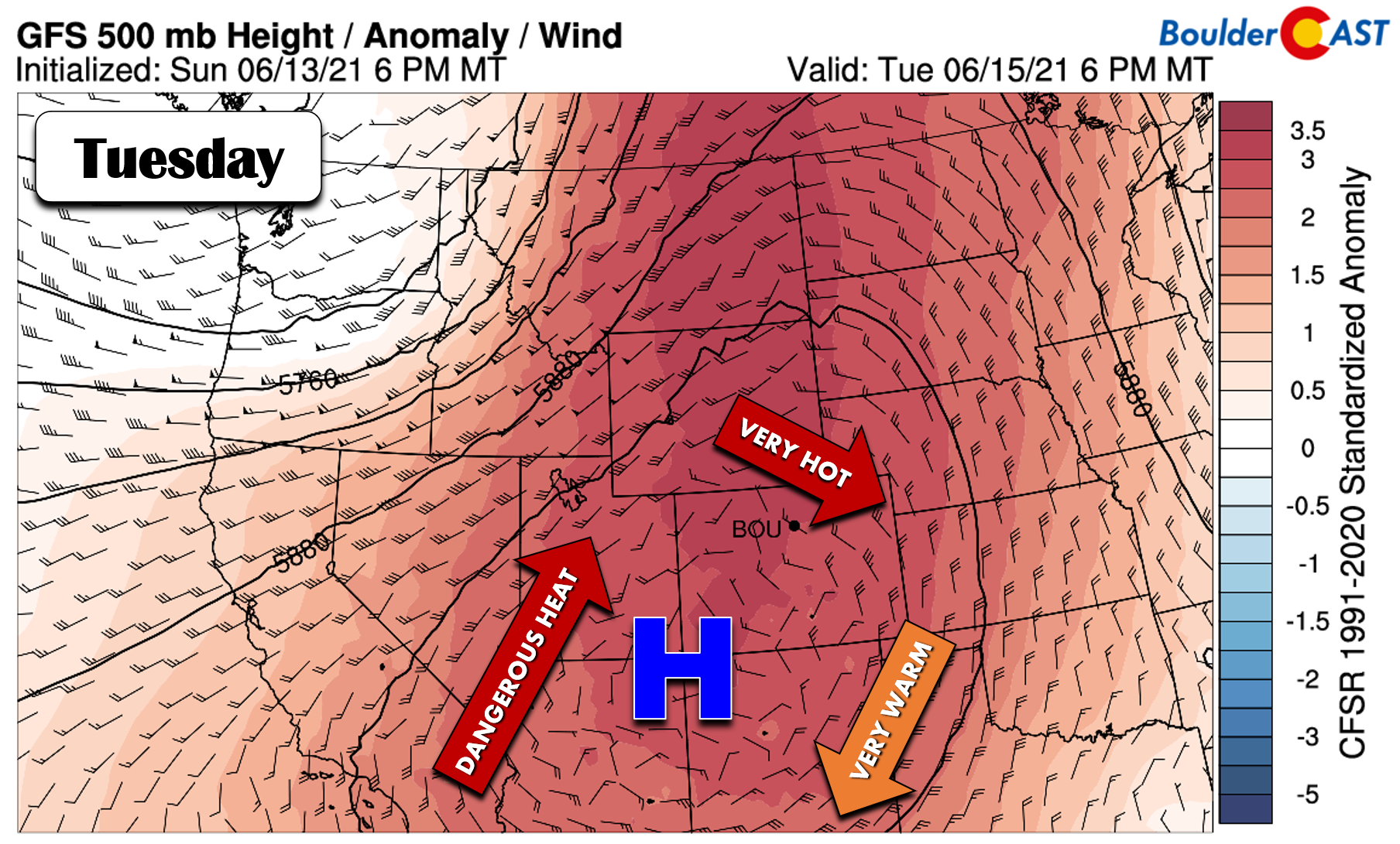
GFS 500mb height anomaly forecast for Tuesday. Clockwise flow around the ridge will produce northwest flow in the Front Range limiting the impacts of the heatwave some
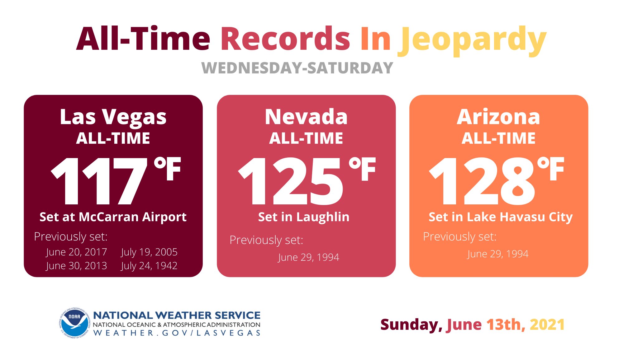
Instead, peak heating with this ridge will land further west and south, mainly in Arizona, Utah, California, and Nevada. Several all-time state and city temperature records will be contended later this week. Here is a graphic from NWS-Las Vegas. Those are some very hot temperatures on the chopping block!
This is probably also not the week to vacation to Death Valley in California. If your car happens to break down along the highway, you’d be in a world of trouble with highs forecast to reach close to 130°F.
Death Valley forecast this week | National Weather Service
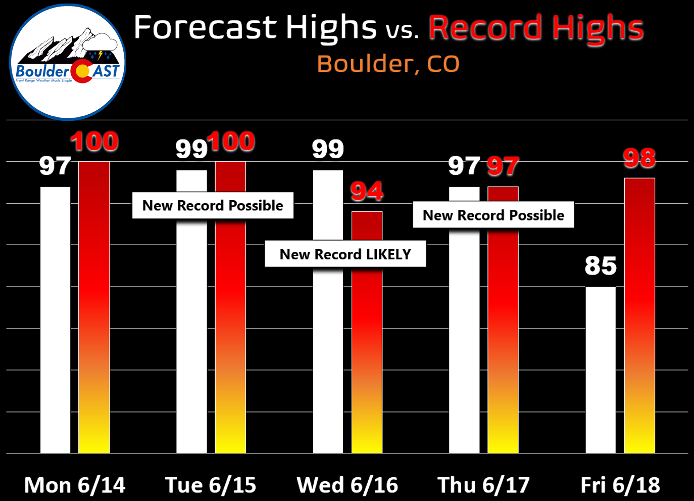
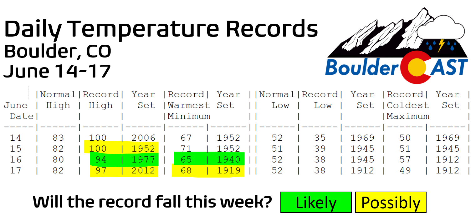
While not an earth-shattering heatwave for the Boulder-Denver area, it’s definitely going to be a hot week, maybe even our hottest of the entire summer ahead. A stretch of weather this hot happens between zero and two times per year for our area! We’re forecasting highs in Boulder to stay in the upper 90’s through Thursday. Areas like Denver, Fort Collins and Longmont will be a couple degrees warmer and have very good chances to reach triple digits during this timeframe. As you can see in the graphic below, new daily records are possible Tuesday and Thursday in Boulder, with Wednesday almost a sure-bet to obliterate the existing record by as much as five degrees.
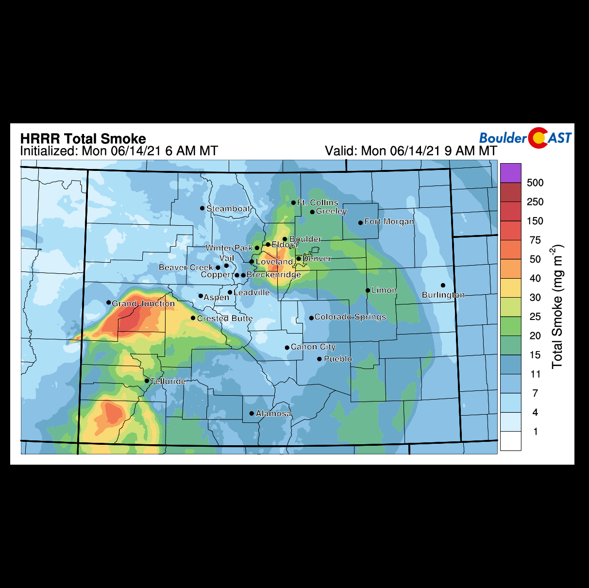
Finally, plentiful smoke from the many active wildfires in the Southwest will be recirculating underneath this ridge and more or less accumulating across Colorado. The forecast animation below of total smoke in the atmosphere spans from Monday morning into Wednesday morning. The thickening smoke through the week could knock a few degrees off our temperatures as well. It’s unclear exactly how much cooling 2 to 10% less solar radiation will have on afternoon highs.
Cooling off a little by late-week
As we alluded to earlier, the anomalous ridge will begin to flatten out and weaken towards the end of the week. A shortwave disturbance trekking along the Canadian border will usher a cold front southward across the central United States. This front is projected to reach the Front Range Thursday night or early Friday, bringing a decisive end to the extreme heatwave for our area. After four straight days near 100°F, Friday’s temperatures are projected to drop back into the middle 80’s. This magnitude and timing of this cooldown is depicted well in most global models which gives us greater confidence for this more pleasant end to the work-week.
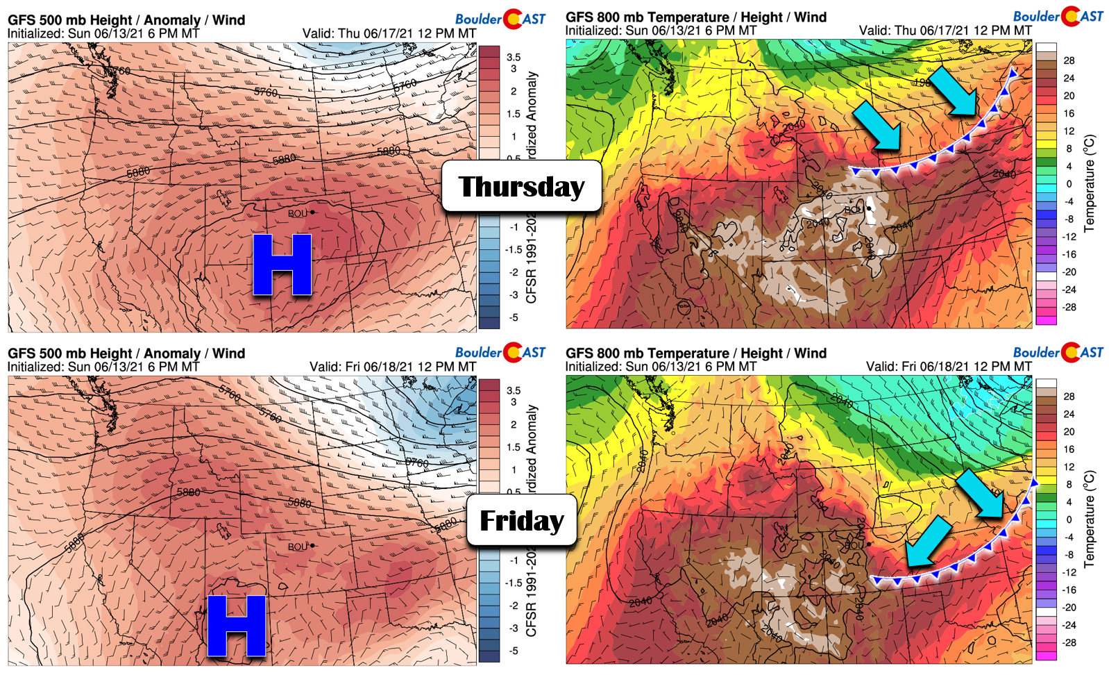
A cold front is progged to reach the Front Range Thursday night paving the way for a cooler Friday
Beginning mid-week, there will be a slight chance of late-day thunderstorms for the area, particularly on Thursday and Friday. However, there isn’t a lot of moisture to work with and the ridge will be trying its hardest to suppress convection. At best we’re looking at isolated storms across the Plains with most of the activity forming across the Mountains and Palmer Divide. Most of us will fail to see any precipitation this week.
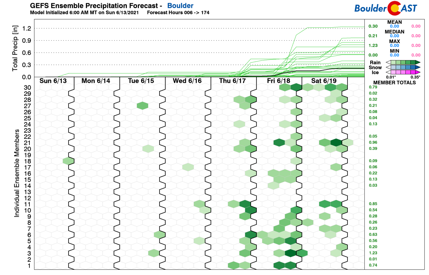
The upcoming weekend will see temperatures creep back up as the cooler airmass washes out with the warmer remnants of the ridge airmass. The Denver Metro area should see highs return to near 90 degrees with continued late-day, meager storm chances.
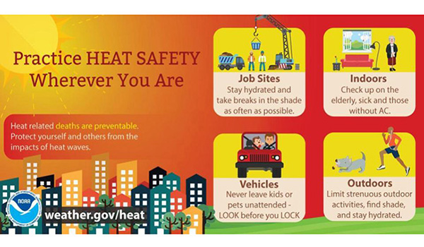
Stay cool and practice heat safety this week!
Stay up to date with Colorado weather and get notified of our latest forecasts and storm updates:
We respect your privacy. You can unsubscribe at any time.
.
Forecast Specifics:
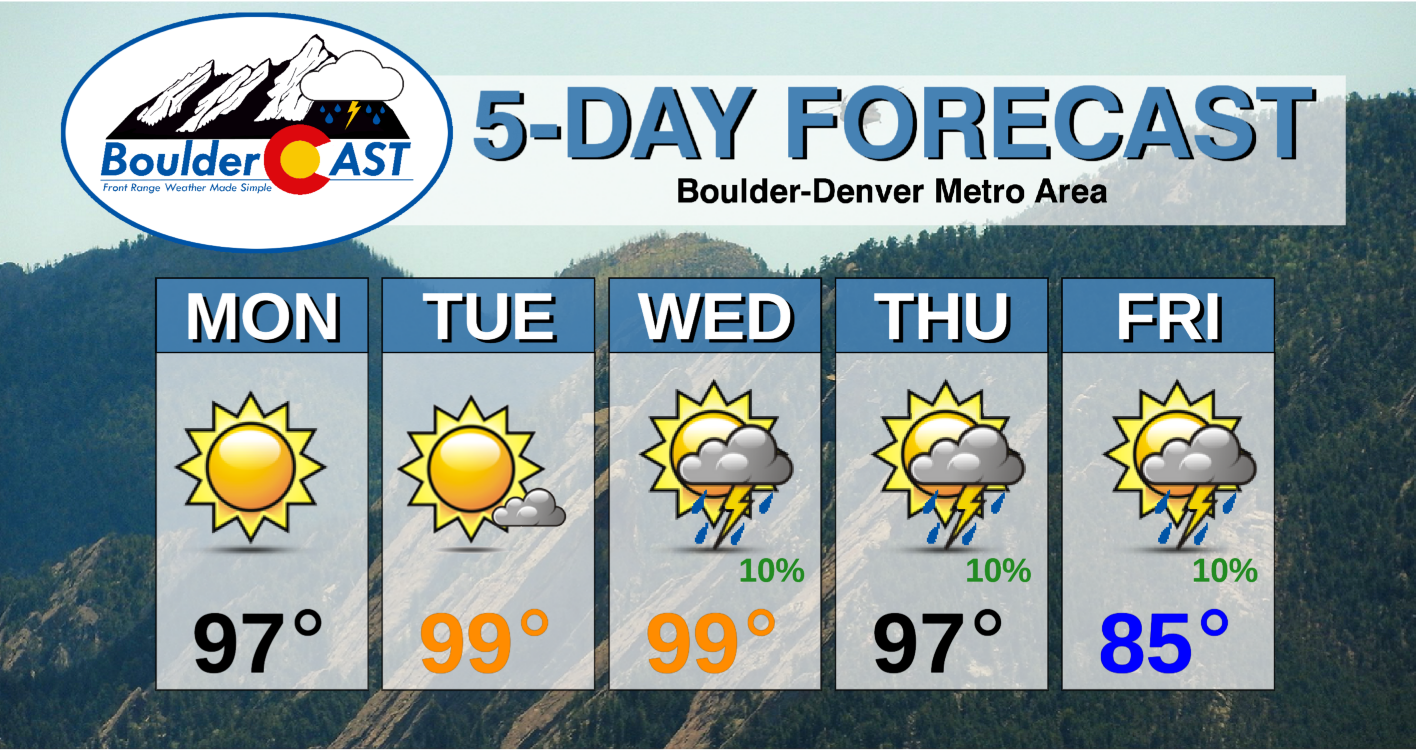
Monday: Sunny and hot with high temperatures in the mid to upper 90’s across the Plains with middle 80’s in the Foothills.
Tuesday: Mostly sunny with near-record heat. Highs near 100 degrees on the Plains and in the upper 80’s in the Foothills.
Wednesday: Increasing clouds with isolated afternoon high-base thunderstorms. Highs approaching records in the upper 90’s to lower 100’s across the Plains with upper 80’s in the Foothills.
Thursday: Partly cloudy and hot with isolated late-day storms possible. Temperatures rise into the mid to upper 90’s on the Plains with mid 80’s in the Foothills.
Friday: After an overnight cold front, it will be much more comfortable with a mix of clouds and sun. Highs in the middle to upper 80’s on the Plains with upper 70’s in the Foothills.
Mountains: It will be unseasonably warm and dry in the Mountains Monday and Tuesday with light winds and mostly sunny skies. Wednesday through Friday will see more clouds with isolated to widely scattered late-day storms Check SummitCAST for up-to-date forecasts of more than 120 Colorado mountain destinations.
Help support our team of Front Range weather bloggers by joining BoulderCAST Premium. We talk Boulder and Denver weather every single day. Sign up now to get access to our daily forecast discussions each morning, complete six-day skiing and hiking forecasts powered by machine learning, first-class access to all our Colorado-centric high-resolution weather graphics, bonus storm updates and much more! Or not, we just appreciate your readership!
.
Spread the word, share the BoulderCAST forecast!
.


You must be logged in to post a comment.