If you are sick of the warmth and lack of decent skiing, this week’s weather will be welcomed. The focus for the week ahead will be a slow-moving trough which takes hold across the center of the country. This will bring an extended period of cooler weather to the region and heavy snow to the Mountains. We’re also monitoring a chance of snow for the Plains towards the end of the week. Read on for our full forecast.
Tree leaves are already beginning to sprout across the Denver area, a result of the extreme warmth over the course of the last six weeks. Almost all of Colorado has been above average, with the Plains leading the way — 10 to 15 degrees above normal over the last 30 days.

This week, however, northeast Colorado is in store for it’s most substantial and extended cold spell in quite some time as a trough deepens across the region. Let’s get into the specifics.
Mountain snow, breezy Plains
The trough can be seen to our northwest in the 500 mb map below, valid Monday afternoon.
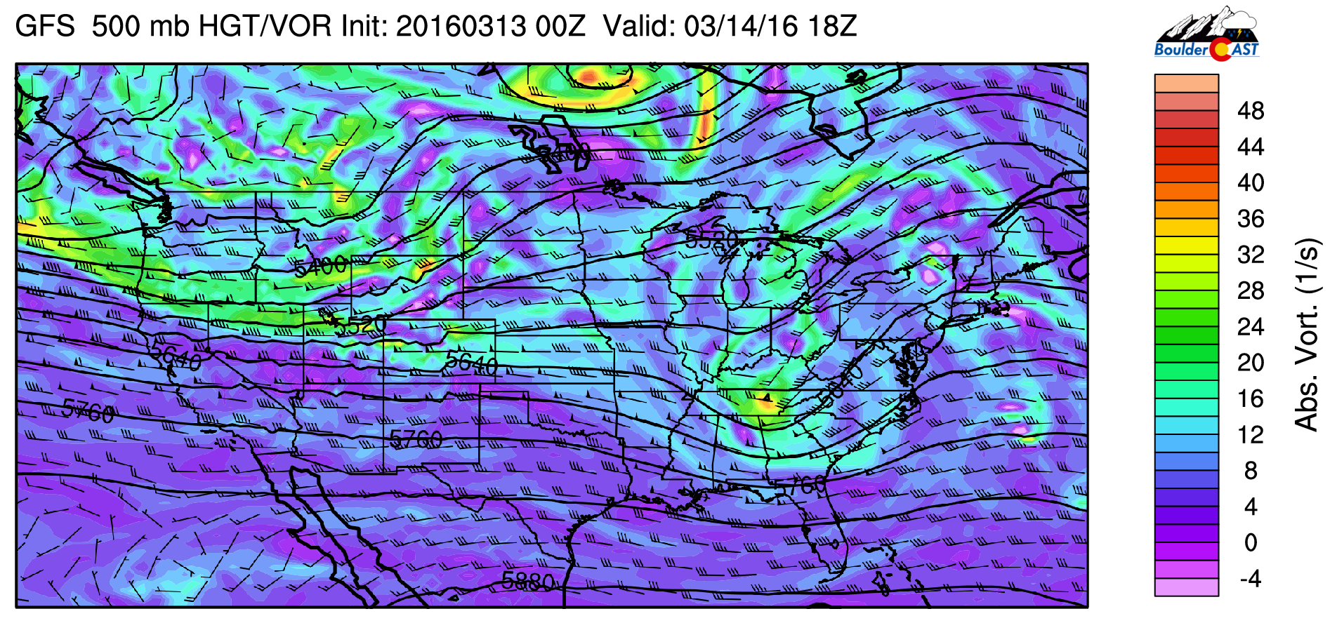
GFS 500mb vorticity map for Monday. Westerly flow builds across Colorado, with a major trough (and cool down) visible over western Canada
Notice the very tight height gradient along a line from northern California into Colorado, with strong westerly flow present. This will rapidly increase Pacific moisture to our region this afternoon. Combining this moist, westerly flow with some embedded energy, we expect moderate to heavy snow to break out across the Mountains by late morning today, continuing into the overnight hours. Based on model guidance, it looks like 6-14″ is a safe bet for most Mountain locations by Tuesday afternoon. Most of this will remain near and west of the Divide.

NAM snowfall forecast through Tuesday night
Today will be relatively warm in the low to mid 60’s, with mostly sunny skies and breezy conditions. The warm temperatures and gusty downslope winds will create prime fire conditions today. Red Flag Warnings may be needed for parts of the Plains. The leading edge of the cooler air arrives via a cold front this evening. Around this time, some light lower elevation rain and Foothills snow will be possible. Though, considering the downslope, it will be light and isolated.
On the back side of the front, Tuesday will be cooler than Monday, with a high in the low 50’s for the Plains. Strong winds aloft will continue to mix down to the surface. At this time, the atmosphere doesn’t appear favorable for a significant lower elevation wind event this week. However, gusts of 20-40 mph will be possible at times through Wednesday.
The 500 mb map for Wednesday is shown below, showing a continuation of downslope flow.

GFS 500mb vorticity map for Wednesday evening showing the trough digging across the central U.S. and WNW flow across Colorado
Under this northwest flow, mountain snow will continue through the day Tuesday and into Wednesday. It won’t be as intense as Monday, but the persistence will likely add up to several inches of additional accumulation. As such, it looks like the best ski day will be Tuesday, but Wednesday would probably be decent as well.
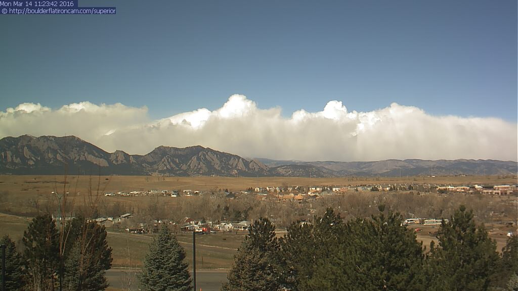
Live image of the Divide as of 11am Monday. Heavy snow has begun! | boulderflatironcam.com
Things get interesting Thursday evening…
On Thursday, a shortwave drops down across Colorado from the north.
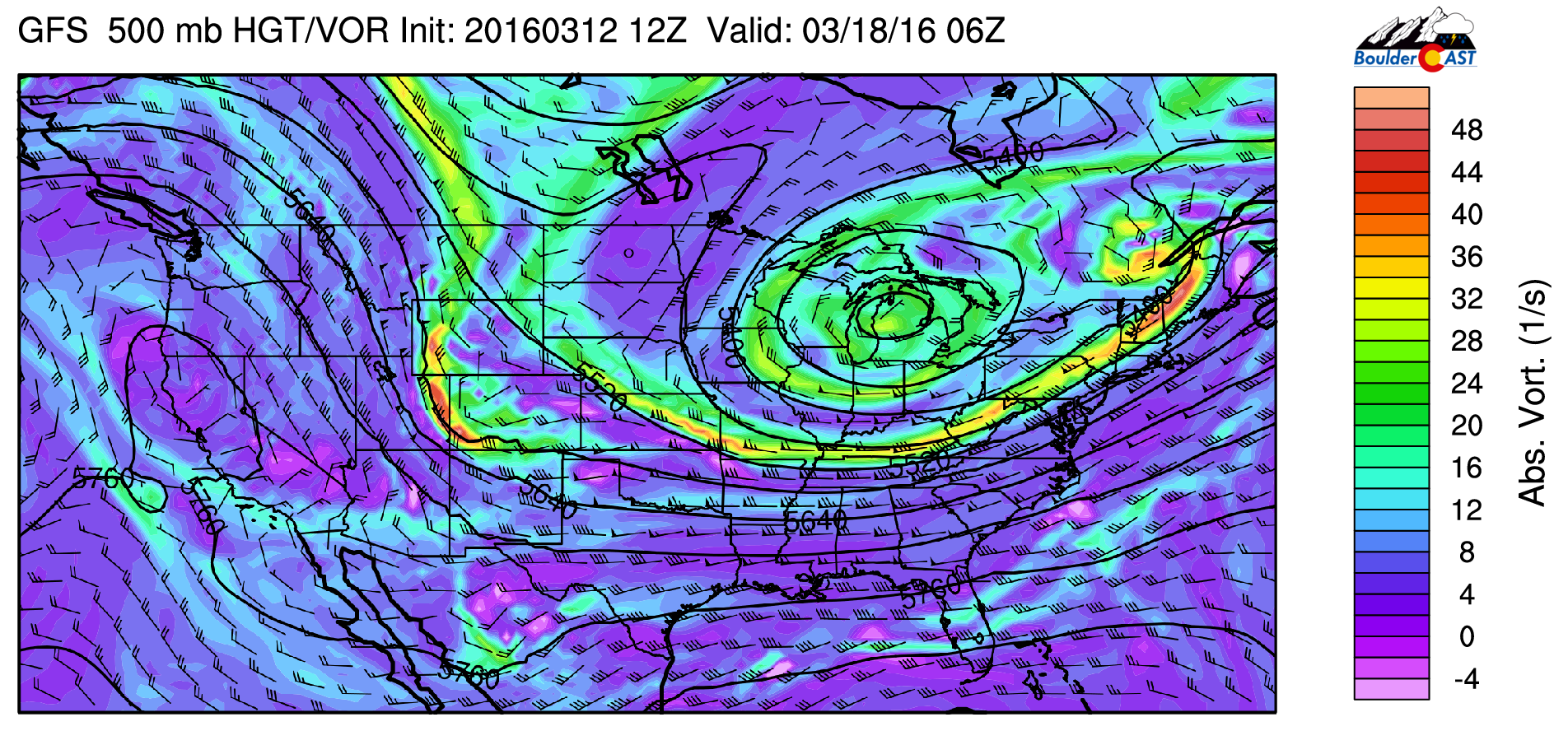
GFS 500mb vorticity map for Thursday evening. A shortwave slides south across the CO/UT border, possibly providing the energy to initiate snow for the Front Range.
This system brings a more significant cold front through during the evening hours, providing a weak but potentially lengthy period of upslope (12+ hours) with it. At the lower elevations, temperatures quickly fall from the upper 30’s into the upper 20’s, so it appears snow will be the precipitation of choice for a bulk of the event. There will be very cold air in the mid levels, so we just need to get the lower levels chilled for widespread snow, which doesn’t appear to be an issue behind the front.
Model differences and the feature’s subtlety are the main red flags at this point. While the GFS and Euro continue to show this snow event for the Denver area, the Canadian has backed off in the recent days, tracking the system further west. In regards to subtlety, any slight shift in track could take the snow elsewhere. The end result remains to be seen, but our confidence is increasing considering the consistency and similar solution in the GFS and Euro.
The upslope will be quite shallow, so the best chances of snow on the Plains may be west of Interstate 25. With that in mind, there exists the potential for several inches of accumulation across the region. Also, timing is critical this time of year. The March sun is strong, and tends to make daytime snowfall less likely and impactful. As of now, the evening arrival and continuation overnight would be favorable to maximize our snow accumulation. Still three days out, the timing and intensity can, and probably will, change. Check back with us later in the week for more details on this potentially snowy forecast.
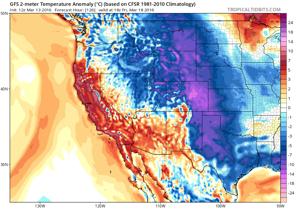
Post snow, Friday looks will be the coldest day of the week. Afternoon temperatures will be some 15-20 degrees below normal (shown below), remaining only in low to mid 30’s under mostly cloudy skies. Snow showers look to come to an end by Friday afternoon. Sunshine and moderating temperatures return for the weekend. In fact, we could be back into the 60’s by Sunday as the ridge rebuilds.
Never miss a BoulderCAST update by subscribing. If you haven’t done so already, please consider taking our short, 2-minute survey. Thanks and enjoy the cool down and snow! Have a great week!
The Forecast:
Monday: Warm and breezy. Party to mostly sunny skies, with a slight chance of rain (higher elevation snow) showers in the afternoon and evening with the frontal passage. Some snow could mix in on the Plains overnight, with no accumulation expected. West winds gusting to 40 mph. Highs in the low 60’s across the Plains, with upper 40’s in the Foothills.
Tuesday: Partly cloudy, breezy and cooler. West winds gusting to 30 mph. Highs in the low 50’s across the Plains and low 40’s in the Foothills.
Wednesday: Mostly sunny and breezy. Still cool, with northwest winds gusting to 30 mph at times. Highs in the upper 40’s over the Plains and upper 30’s in the Foothills.
Thursday: Partly cloudy early, with increasing clouds. Rain beginning in the evening, changing to snow in the late evening. Several inches of accumulation are possible overnight into Friday for the region. Look for our forecast update later in the week. Highs in the mid 40’s for the Plains, with mid 30’s in the Foothills.
Friday: Snow showers lingering into the late morning or early afternoon. Mostly cloudy, with highs in the mid 30’s across the Plains, with low 20’s in the Foothills.
High Country: Snow will increase substantially in intensity Monday early afternoon through Monday night. 6-14″ is possible by Tuesday afternoon. Snow lingers into Wednesday. After a slight decrease in action Thursday morning, snow picks up once again Thursday afternoon into Friday morning. In total, we are looking at 10-20″ through the week, with favored spots for northwest flow picking up 2+ feet.
| Source | Mon | Tue | Wed | Thu | Fri |
|---|---|---|---|---|---|
| BoulderCAST | 63 | 49 | 48 | 44 | 34 |
| NWS | 62 | 47 | 46 | 46 | 37 |
| AccuWeather | 63 | 47 | 46 | 44 | 34 |
| The Weather Channel | 60 | 48 | 50 | 46 | 33 |
.
.Last week’s recap:
Here are the results of last week’s forecast. First, the forecasts and observations from all of the sources:
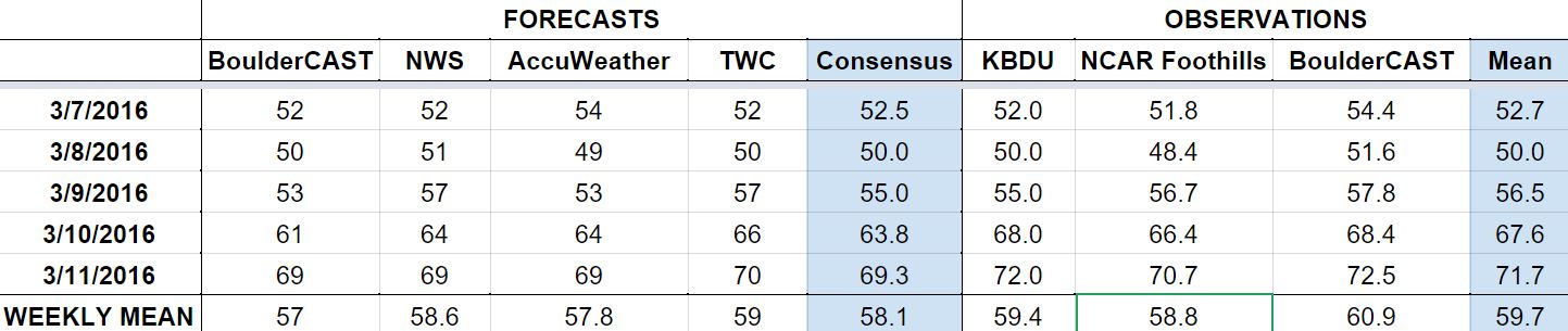
Last week we forecasted a mild start to the week, with warming temperatures to close it out. Our only mention of precipitation was a slight chance of rain/snow on Monday, which did verify. Boulder only registered a trace of rain/snow, but some locations near Aurora picked up more significant rain and even a wet inch or two of snow.
Let’s look at the error analysis. Shown below is the amount of degrees (in Fahrenheit) that each source was off from the mean observed temperature for Boulder. Positive values indicate the forecast was warmer than what actually occurred, while negative values arise from a forecast that was cooler than what was observed.

Overall a great week of forecasting. The day with the greatest error was Thursday, but even then, only 3.9 degrees. A week this well forecast in March is hard to come by, especially considering the range of possible temperatures.
The bottom row of the error table shows the weekly mean error for each weather outlet, a good measure for who was the best and more consistent “forecaster” for the week. First place goes to The Weather Channel with 0.9 degrees of error. BoulderCAST had the best forecast two days during the week, but came in last place, mostly a result of some bad intuition about a slight cool down on Thursday.
Header photo credit: Zack Pyle


You must be logged in to post a comment.