
After two straight weeks of mostly sunny and warm conditions, the week ahead will feature quintessential Colorado fall weather. With the passage of two cold fronts, we’ll transition from the 80’s early in the week, through wind, rain and cold…to the potential for snowflakes by week’s end. Continue reading for our complete outlook of the week ahead.
—
We’ve been monitoring this week’s shifting weather pattern for a while now, first mentioning it in last week’s extended forecast. Back then, confidence was very low, but it was obvious that we would be saying goodbye to the 80’s sometime this week. Things are now starting to come into a blurry focus. Let’s jump in…
Warm and windy to start the week
As always, let’s begin with a look at today’s 500 mb upper-air map to get an idea of the main weather players. Below you can see the departing ridge across the middle of the country (which gave us a beautiful weekend), with a sizable trough plowing into the Mountain West. This trough will be our focus for the week.
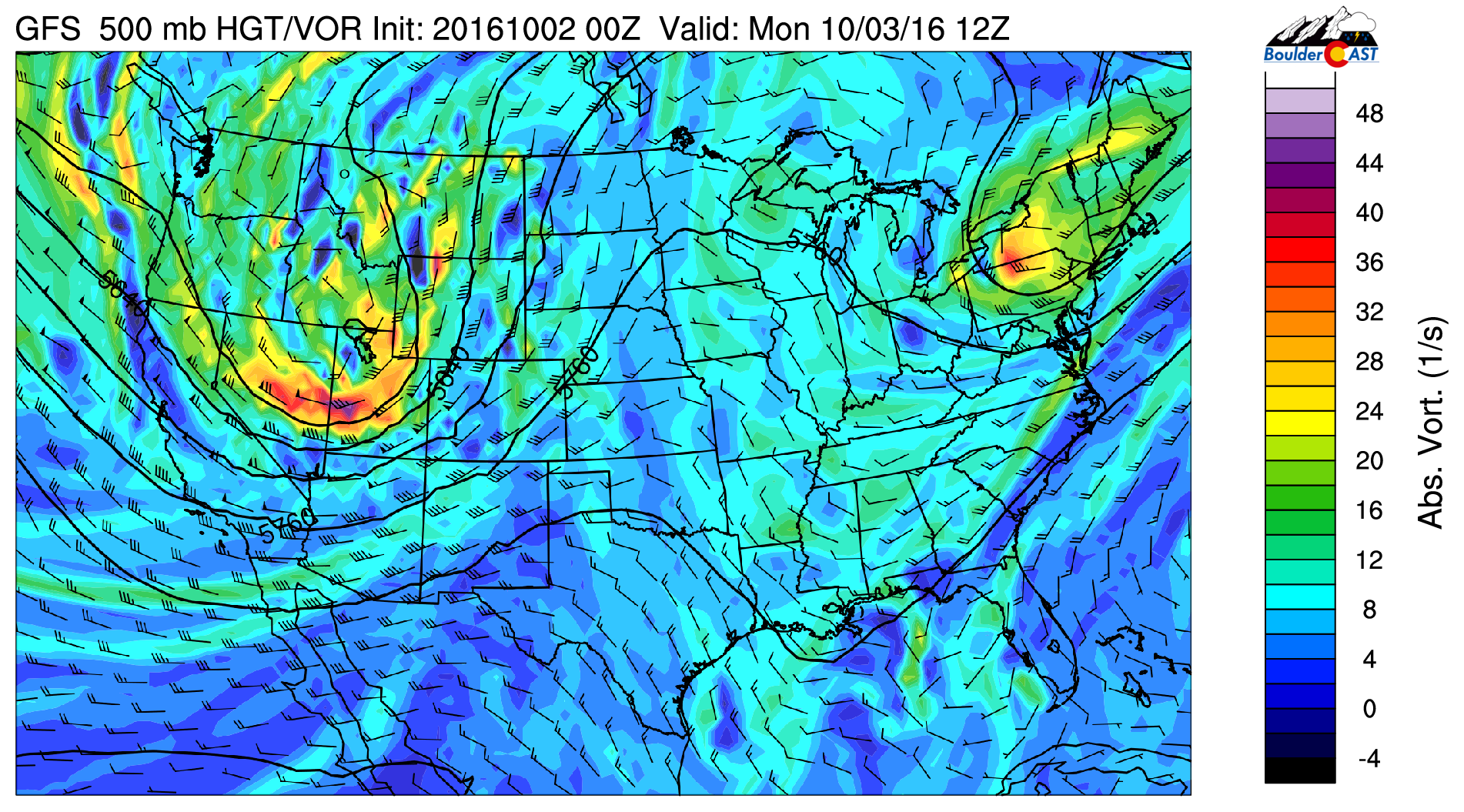
GFS 500 mb vorticity map for Monday morning, showing a large trough approaching from our west
Ahead of this trough, wind barbs across Colorado show 40 to 60 mph southwesterly winds at 18,000 feet (see above 500 mb map). With this, the strong winds aloft will mix down to the lower levels, bringing breezy and borderline windy conditions for today and tonight. Expect winds in the 15 to 25 mph range, with some gusts nearing 40 mph.
Alongside the warm and dry downslope winds, temperatures will be in the low 80’s across the Plains with a mix of clouds and sun. We’re not expecting any precipitation. These conditions will be optimal for the spread of wildfires and it makes sense that Red Flag Warnings are in effect for the region. Please use caution!

Bidding adieu to the 80’s
Later tonight, a cold front associated with the trough will slide across Colorado from the northwest bringing an end to our summer-like weather for the time-being. Will Monday be our last 80-degree day of 2016? It very well could be, so enjoy it! Behind the front, the rest of the week will be chilly and eventually, downright cold!
Below shows the position of the front at 6PM tonight. With this Pacific front’s immediate passage, we could see a few strong northwesterly wind gusts.
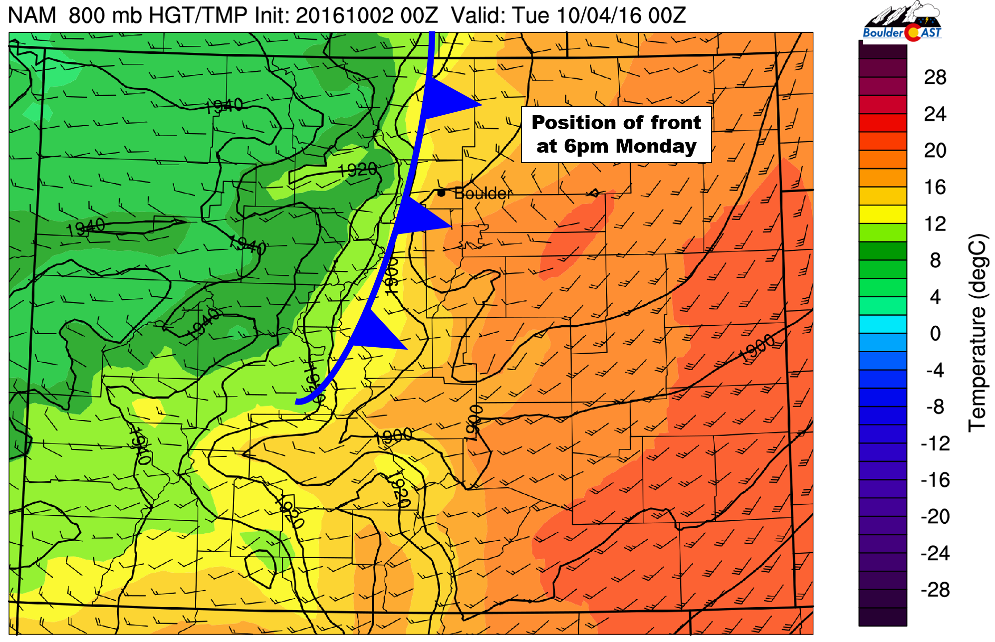
NAM 800 mb temperature map for Monday evening, showing the position of the front
On Tuesday, downslope continues with abundant sunshine. Temperatures will only reach in to the mid to upper 60’s, some 15 degrees cooler than Monday. With a very stable airmass in place, the entire state of Colorado will be high and dry.
Much colder and even some snow
While that first trough won’t make it far enough south to bring precipitation, or even the really cold air into our region, a secondary trough develops late Wednesday and Thursday which could do just that (see below).
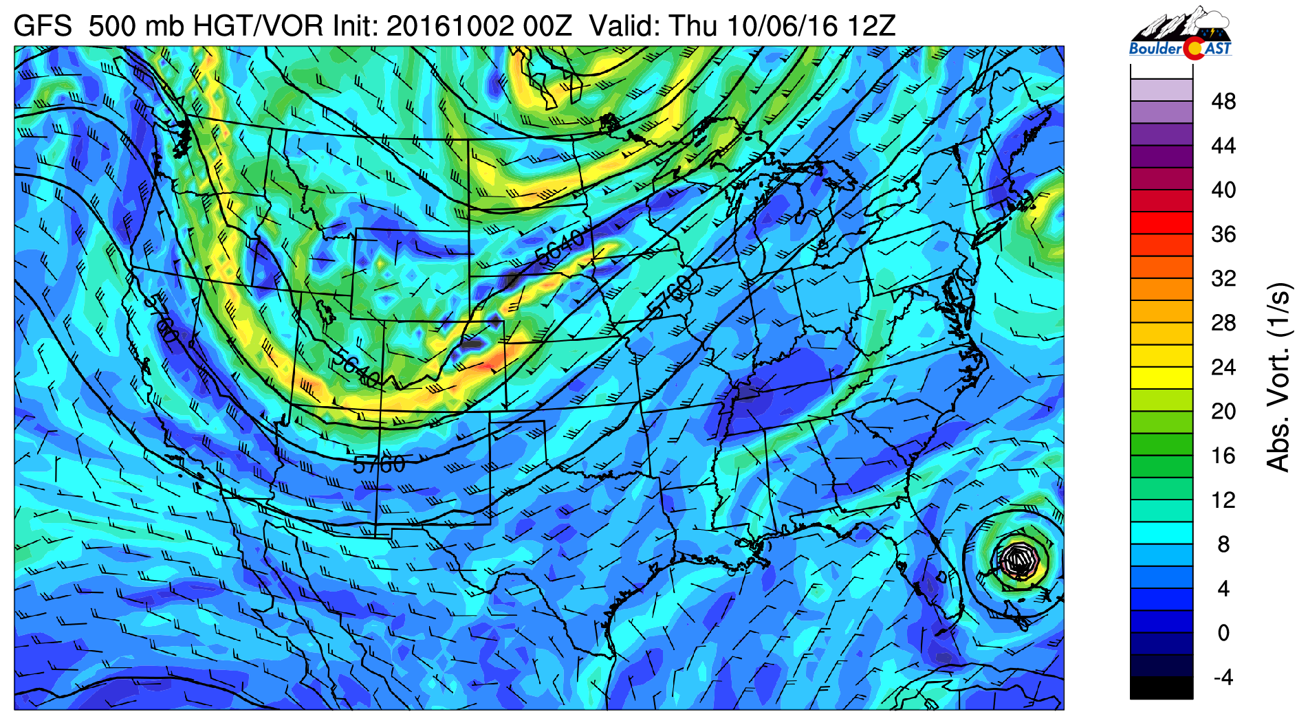
GFS 500 mb vorticity map for Thursday morning, showing a secondary trough in a much more favorable position moving across Colorado
The two maps below show this nicely. On the left is Tuesday’s 700 mb temperature map. On the right, Thursday’s.

Notice how much colder the air mass in Colorado is Thursday compared to Tuesday (20 to 25 F at 10,000 feet Thursday). A keen eye may also notice indications of upslope in northeast Colorado on the rightmost map. With that, we’ll need to discuss frozen precipitation once again for the Denver Metro area!
After a dry day Wednesday and temperatures in the mid 60’s, most model indication has a cold front moving in, this time with colder air and some upslope, Wednesday evening. This will produce increasing clouds Wednesday night and eventually some light precipitation by Thursday morning as some upper-level forcing arrives (thanks to the trough) alongside another push of cold upslope. Below is the GFS model’s depiction of Colorado’s precipitation and wind field Thursday at noon.
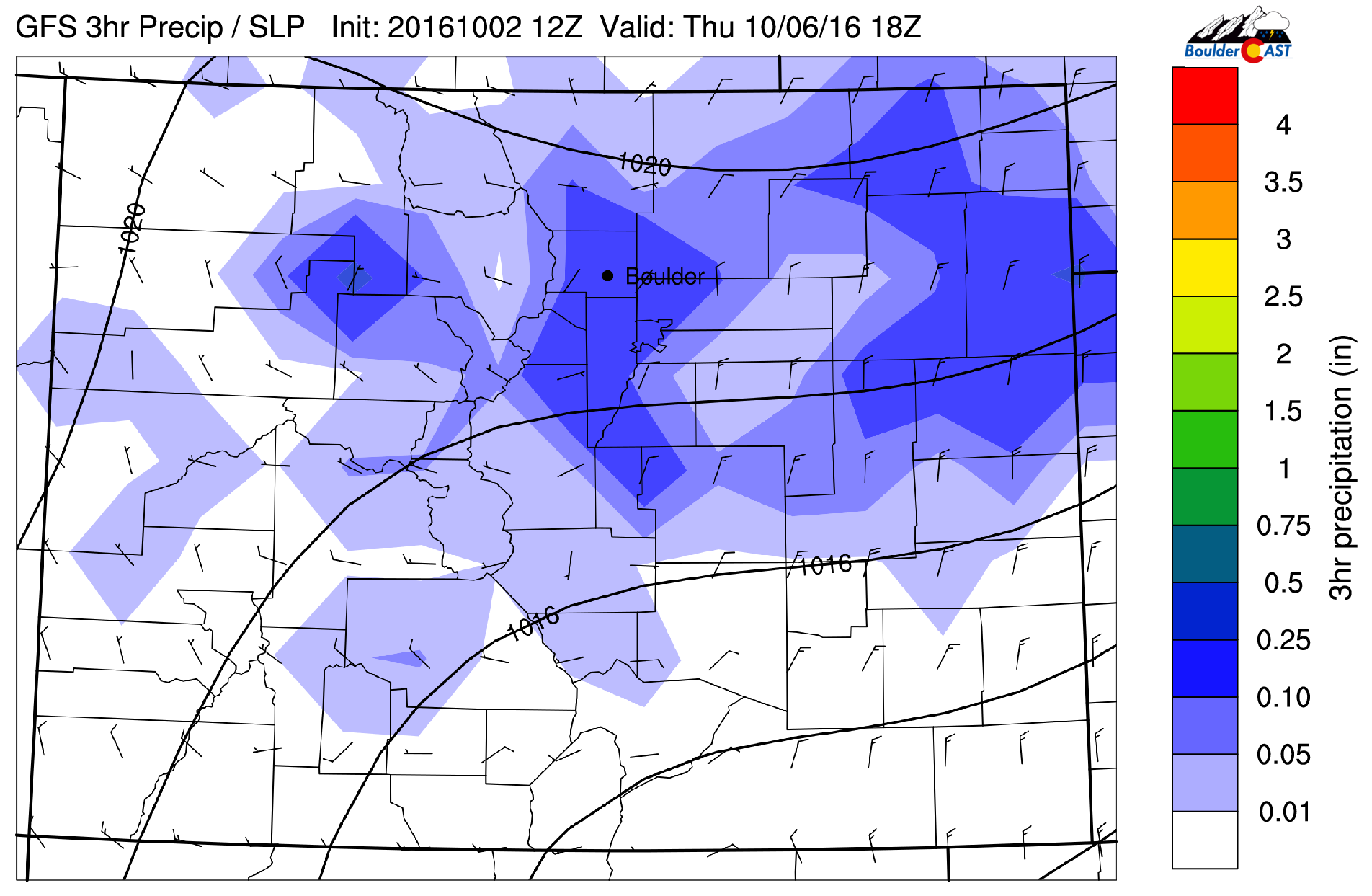
GFS precipitation and sea-level pressure forecast map for noon on Thursday, showing scattered showers across the Front Range and weak upslope flow
We see some light and scattered precipitation beginning to develop. What about those temperatures? Shown below is the 700 mb temperature map for the same time.
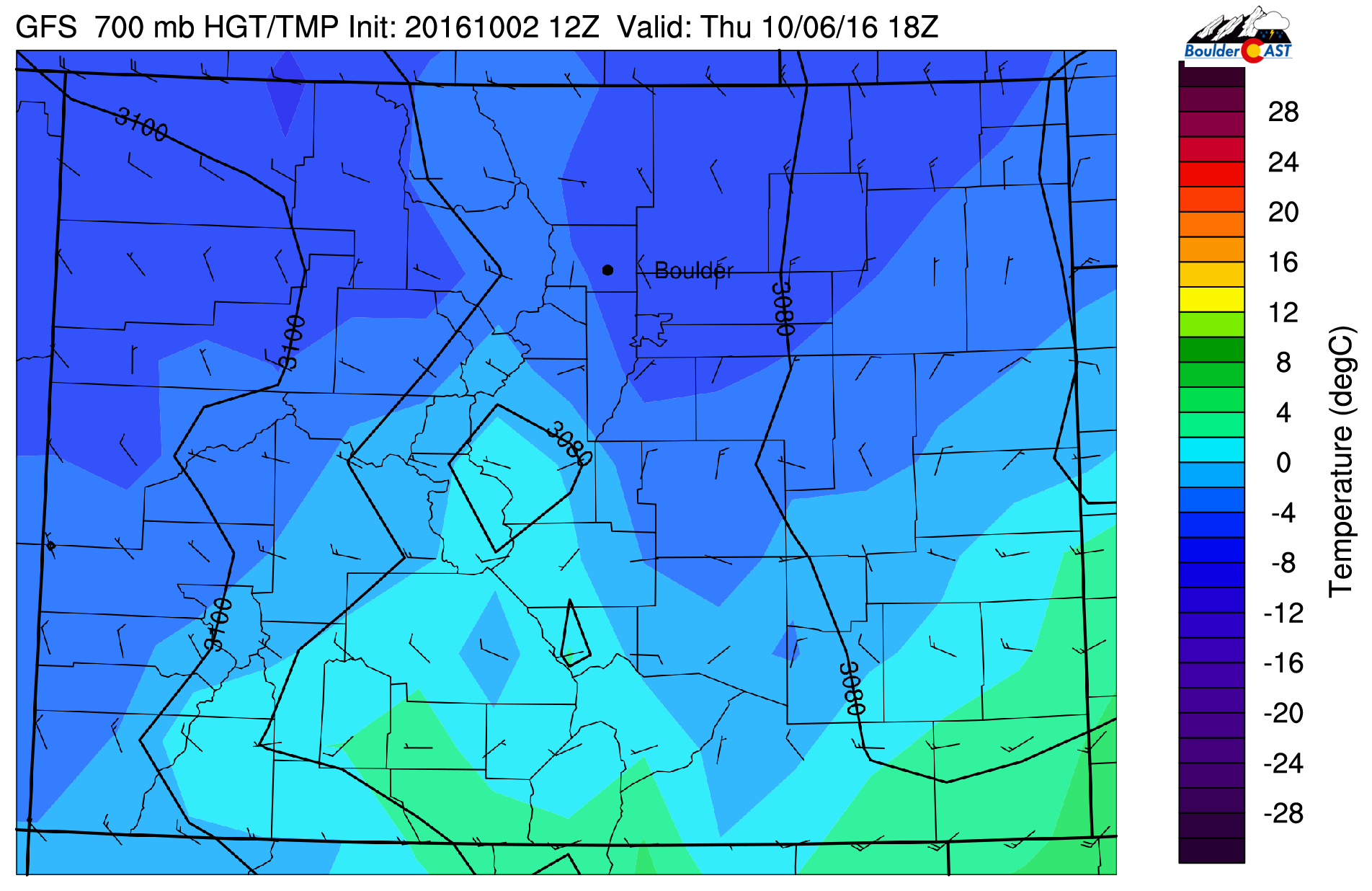
GFS 700 mb temperature and wind forecast for Thursday at noon, indicating temperatures cold enough to possibly support some snow on the Plains
700 mb temps are predicted to range from -2 C to -5 C across the Front Range, suggesting wet snowflakes on the Plains aren’t out the question Thursday sometime, though this puts accumulating snow levels at or above 6,500 feet.
HOWEVER, there is one caveat to all of this….the GFS model is currently somewhat of an outlier in predicting how this storm system evolves later this week. Although the appearance of the 500 mb trough is similar in the European and Canadian models (see below), there are some nuances. Both of the other models produce much less precipitation in northeast Colorado, and they aren’t quite as cold.
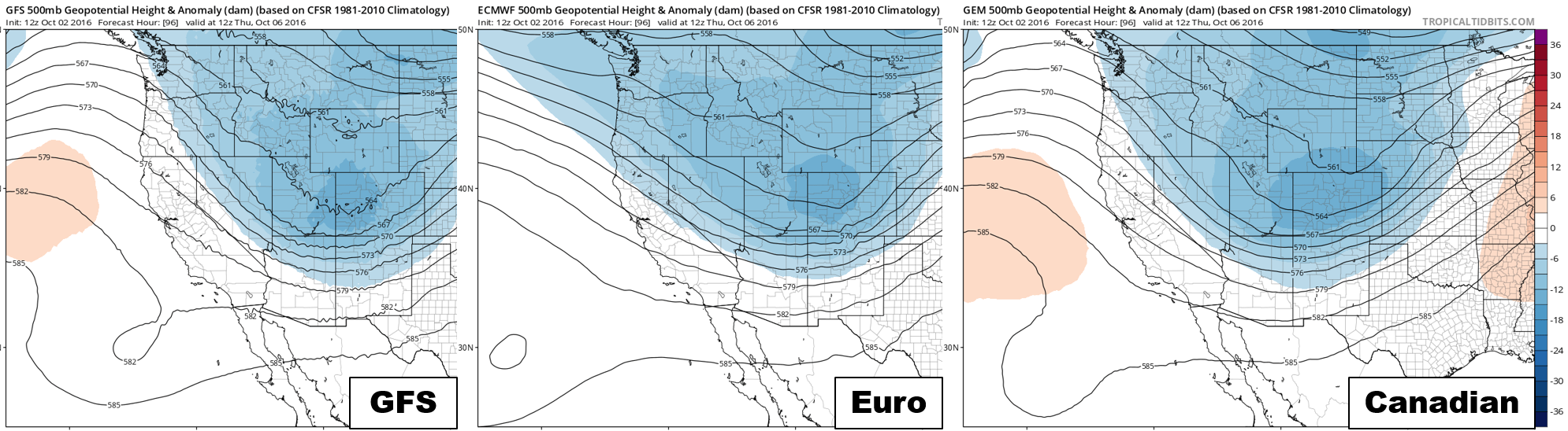
500 mb height maps for Thursday morning from the various models, showing relative consistency
If you followed along with us through last winter, you know the devil is ALWAYS in the details for the Front Range! Though, if it’s any consolation, over the last few days the models seem to be converging on a solution that is closer to that of the GFS, trending colder and producing precipitation slightly further south. The GFS continues to stick to it’s guns (despite how misguided they may be). Still four days out, we’re not going to proclaim “SNOW FOR EVERYONE!” There is still too much up in the air, and even if the GFS does verify, we’re talking maybe a couple of inches in the Foothills, with just a few wet flakes on the Plains. However, we are including the forecast snow amounts from the GFS below to give the snow-lovers some hope!
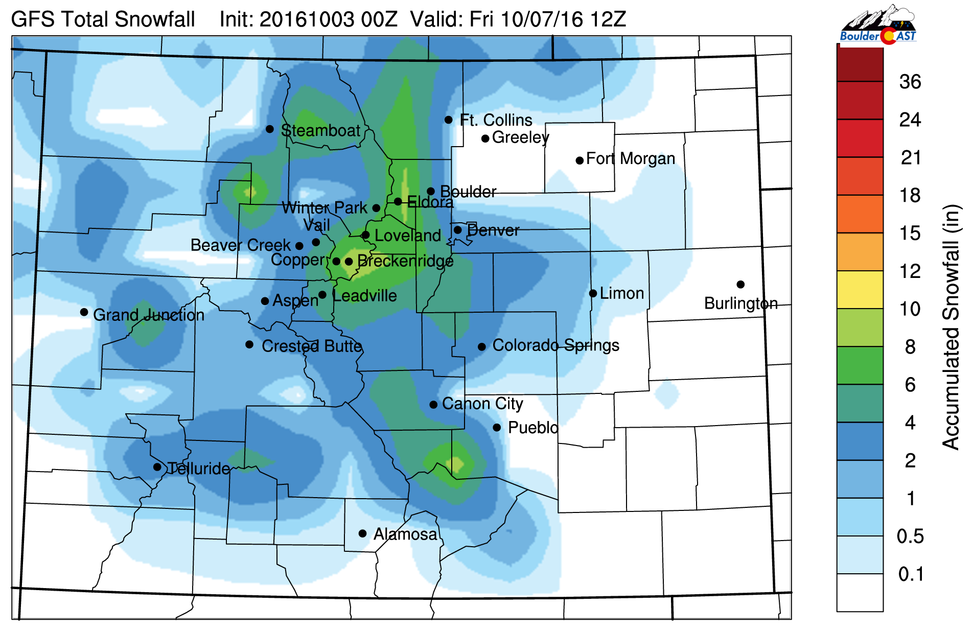
GFS snowfall forecast for Thursday’s storm, showing sizable totals across the Foothills and even some snow at the lower elevations
For now, plan on a much colder and drearier day Thursday. Showers will be light and on-and-off through the day, with possibly some snow mixing in at times on the Plains, with no accumulation. In the Foothills, a slushy inch or two may be possible above 7,000 feet, but this really depends how things evolve over the next few days.
By late Thursday evening, precipitation should be wrapping up and the clouds beginning to clear as drier air moves in. This opens the door for what is likely to be our first frost of the year, if not hard-freeze, Friday morning. Models currently vary from upper 20’s to mid 30’s, so at the very least, widespread frost should occur at the lower elevations.
We end the week chilly but sunny on Friday. Look for dry conditions statewide, with highs in the upper 50’s. The weekend looks just as spectacular, too.
Have a great week! Let’s all welcome fall with open arms!
Forecast Specifics:
Monday: Partly to mostly sunny, warm, and breezy conditions through the day. South-southwest winds 10 to 20 mph with gusts approaching 40 mph. Highs near 80 degrees on the Plains, with upper 60’s in the Foothills.
Tuesday: A few clouds early with clearing thereafter. Mostly sunny and dry everywhere with highs in the mid 60’s on the Plains with mid 50’s in the Foothills.
Wednesday: Some sun early with increasing late-day clouds. There may be a few isolated light rain showers in the Foothills before midnight. Highs in the mid 60’s for the Plains, near 50 in the Foothills.
Thursday: Overcast, dreary, and colder with on-and-off showers through the day. Most of this should be rain on the Plains, but some snowflakes could mix in at times. In the Foothills above 7,000, expect light snow showers, with minor accumulations. Highs only in the upper 40’s on the Plains with upper 30’s in the Foothills.
Friday: After our first frost or freeze of the year in the morning, expect lots of sunshine with no precipitation. Highs in the upper 50’s for the Plains and in the mid 40’s in the Foothills.
High Country: Some light rain/snow showers will be possible early Monday alongside gusty winds up to 50 mph. After a dry day Tuesday, snow showers return Wednesday and Thursday with several inches of accumulation possible. Sunshine and dry weather will then prevail Friday right through the weekend.
Extended: After the active weather to end this week, things look to quiet down again just in time for the weekend (dry and sunny for all of Colorado both days this weekend). Early indication has a big ridge building across the western USA early next week. With this, we’ll look for above normal temperatures and generally dry conditions for next week.
Mon
Tue
Wed
Thu
Fri


Temperature
80
66
64
48
58


Precip Chc (Plains)
0%
0%
0%
40%
0%


.


You must be logged in to post a comment.