The weather has been quite cool and gloomy across the Front Range the last few days. Saturday’s thunderstorms gave parts of Boulder County their most significant precipitation in nearly three months. The week ahead will see a continuation of the wet weather and cooler air, but 80’s could return for the weekend. Read on for all the details.
While the official Boulder NWS site only recorded 0.19″ of rain this past weekend, BoulderCAST got slammed with 0.68″ and a (pea-sized) hailstorm! This was nearly as much rain the fell during the entire months of August and September combined! As seen below, the northern part of the county (and city) made out a little better than the southern areas.
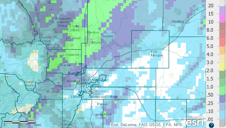
72-hour precipitation totals, ending Monday at 8am.
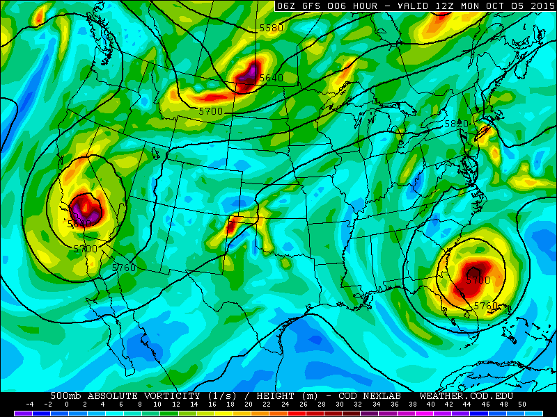
There are currently two large cut-off low pressure systems impacting the United States; one offshore of Georgia and another over southern California. The former was responsible for steering Hurricane Joaquin away from the eastern seaboard, as well as historic flooding in the Carolinas, while the latter will be Colorado’s major weather player the first half of the week. Both of them can be seen below.
The cut-off low in California is forecast to stay relatively far to our south and west (for now). The model consensus has it slowly tracking right along the United States/Mexico border, reaching west Texas by Thursday afternoon, a track will unfortunately limit our precipitation from the system. However, there is some moisture and weak southwesterly flow aloft in Colorado. This will keep conditions gloomy and, at times, wet for Boulder County.
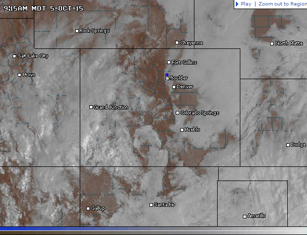
With plenty of low-level moisture, and cool temperatures, this morning had much of eastern Colorado shrouded in low clouds and fog, but only on the Plains. The Foothills, Mountains, and Palmer Divide are all above the fog. This will be the case for most of the mornings this week.
Monday will see the fog lift, some sunshine, cool temperatures, and isolated showers across the Plains. The higher elevations will see more sunshine, especially early in the day. This will fuel the formation of a few thunderstorms, which eventually may make their way onto the Plains. High temperatures will be in the 60’s in most places.
Tuesday will be similar to Monday, but with a better chance of rain, especially in the evening hours and overnight. This is a resulting from a plume of sub-tropical moisture; precipitable water increases from Monday’s values around 0.4″, to near 0.8″ by Tuesday afternoon. Our best chance of appreciable rainfall will be between 6pm Tuesday and 6am Wednesday. Temperatures will be very similar to Monday.
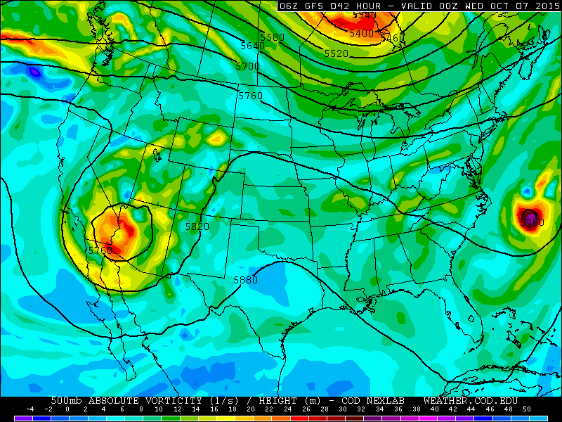
GFS 500mb vorticity map, valid at 6pm Tuesday
After a chance of early morning showers on Wednesday, the threat of rain will persist through the day once again. Showers will be more spotty in nature, as the moisture content of the atmosphere decreases slightly. Skies will be partly cloudy, with temperatures reaching into the low 70’s.
It’s that time of year again that snow levels need to be considered for each passing weather system, especially by those with skiing or snowboarding expectations. This week, since this “warm” storm has Pacific origins, snow levels will remain at or above ~11,000 feet, with slightly higher levels during the daytime hours. We don’t expect much accumulation at all. The highest mountains will only see a couple of inches or less, with those having southwest exposure doing the best. Snowfall totals from the latest run of the 4km WRF model are shown below and support these amounts.

Forecast snow accumulation from the 4km WRF model through Thursday afternoon: a dusting to an inch and only on the highest peaks.
Thursday, the upper-low sags further south into Mexico, and northwesterly flow takes over across northern Colorado (see below). This flow pattern should dry things out for us.

500mb vorticity map, valid at 6pm Thursday. Our upper-low has now shifted to northwesterly.
In the lower atmosphere, a shallow cold front trailing behind the trough over the Midwest will move into northeast Colorado. Models indicate this front should arrive during the morning Thursday. The cooler air will only graze the region, so expect highs only a few degrees cooler (also considering a mid-level deck of clouds that could be in place), with highs topping out in the upper 60’s. The cold front is seen below at the 700mb level Thursday morning.
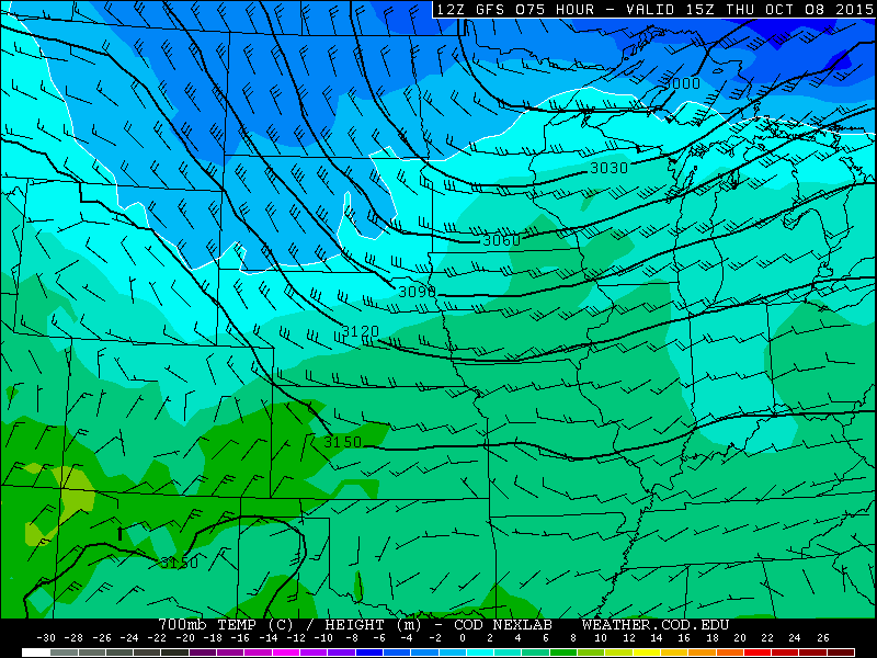
700mb temperature and wind map from the GFS, valid at 9am Thursday. It shows the leading edge of the “cold” air entering NE Colorado (northerly wind vectors).
Friday will see northwesterly flow aloft and a slight rebound in temperatures, with no chance for precipitation. Expect highs in the low to mid 70’s on Friday, with even warmer temperatures and sunshine on tap for the weekend!
Uncertainty: The biggest source of error this week comes from the exact track of the upper-level low, especially during the second half of the week. Its current track produces dry weather to end our week. However, we take this track with somewhat of a grain of salt, since models don’t handle these type of features well. We are confident in the forecast through Wednesday, but uncertainty jumps at the end of the period. For now, we will follow the models predictions, but be aware Thursday and Friday could look a little wetter or warmer. For example, current runs have the low retrograding westward in Mexico, remaining somewhat stationary, and then impacting Colorado once again on October 17th.
The Forecast
Monday: Fog and low clouds in the morning, then increasing clouds. Scattered showers or thundershowers are possible, especially in the Foothills. Highs in the mid 60’s in the Foothills, with upper 60’s on the Plains.
Tuesday: Early morning fog, with skies remaining mostly cloudy through the day. Showers and thunderstorms likely in the late afternoon, through the evening and overnight into Wednesday. Highs in the upper 60’s on the Plains, with low 60’s in the Foothills.
Wednesday: Some showers early, then partly cloudy through the day, with isolated showers possible. Highs in the low 70’s on the Plains, with mid 60’s in the Foothills.
Thursday: Partly cloudy and drier. Just a slight chance of isolated storms in the Mountains and Foothills. Dry on the Plains. Behind a weak cold front, highs will only reach the upper 60’s across the Plains, with low 60’s in the Foothills.
Friday: Mostly sunny, dry, and mild. Highs will rebound into the low 70’s on the Plains, with mid 60’s in the Foothills.
High Country Forecast:
Expect scattered showers/storms Monday through Wednesday in the Mountains. The best chance of rain (with snow above 11,000 feet) will be Tuesday night into Wednesday. Only an inch or two of snow accumulation at most. Thursday and Friday will be drier, and a bit breezier under northwesterly flow.
Source
Mon
Tue
Wed
Thu
Fri


BoulderCAST
69
70
74
68
74


NWS
68
69
72
70
72


AccuWeather
67
70
74
71
75


The Weather Channel
68
69
72
65
70
Last week’s recap:
Here are the results of last week’s forecast. First, the forecasts and observations:
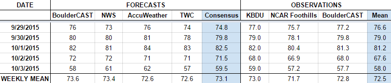
The consensus was for warm temperatures early in the week, with a big cool down towards the end of the period as an upper-level system and cold front invaded Colorado. We forecasted just an outside chance of rain Tuesday/Wednesday, with a near certainty for rain Friday night into Saturday. This forecast verified well, as Boulder got shots of precipitation Tuesday (0.06″), Friday (0.02″), and Saturday (0.60″), with nothing recorded the other days.
Now the error analysis. Shown is the amount of degrees (in Fahrenheit) that each source was off from the mean observed temperature for Boulder. Positive values indicate the forecast was warmer than what actually occurred, while negative values arise from a forecast that was cooler than what was observed.
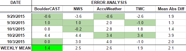
Most days this week were forecast fairly well by most outlets. The day with the largest error was Friday (Oct 2). Extensive cloud cover out ahead of the weather system, coupled with light rain showers, kept highs cooler than forecast (68 degrees, instead of the forecasted 72).
The bottom row of the error table shows the weekly mean error for each weather outlet, a good measure for who was the best and more consistent “forecaster” for the week. Not surprisingly, the best overall forecast for last week goes to BoulderCAST, with only 1.4 degrees of error averaged across the period, with BoulderCAST having the best forecast three days out of the week. BoulderCAST has now had the best forecast three weeks in a row, and four out of the last five! Check back next week to see if the trend continues.
—
If you haven’t already done so, follow us on Twitter or Facebook for frequent weather updates and subscribe to the site to get these posts automatically delivered to your email box (enter your email in the sidebar widget to right).
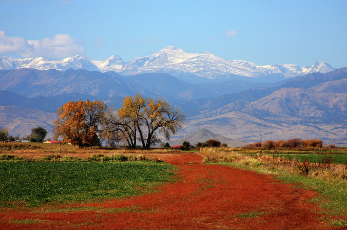
Featured Image Credit: Fine Art America


You must be logged in to post a comment.