A cold front pushed through the region yesterday afternoon and behind it, northeasterly winds ensued with isolated showers across northeast Colorado. That will make for a cooler day today, with a quick return to the 80’s by Wednesday. Big changes are on the horizon, though! Could portions of Boulder County see snow showers come Friday? Continue reading to find out!
We had a few sprinkles last night (not measurable), ending our three week dry period! The front has brought in easterly flow, as evident in the below 850 mb temperatures as forecasted from the GFS model. It shows cooler temperatures across northeastern Colorado, with a dome of high pressure to the northeast over South Dakota. Due to low-level moisture in place and easterly upslope flow, expect lots of clouds around today with sunshine slowly working in by late afternoon. Temperatures will be cooler in the mid 70’s.
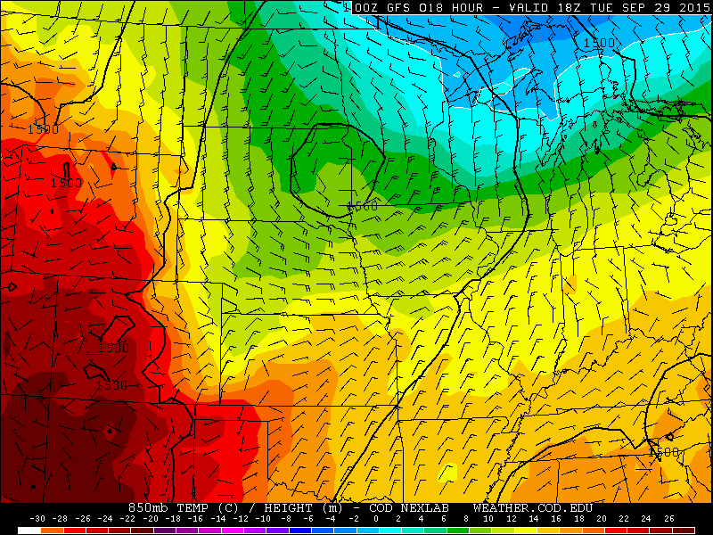
850 mb temperature and wind for Tuesday as forecasted from the GFS model
In addition to the cooler temperatures and cloud cover, there is some weak instability that the GFS model is showing for this afternoon. With the easterly upslope flow and low-level moisture, isolated showers and possibly a thundershower are possible across Boulder County by mid to late afternoon. Any showers that do form won’t produce much precipitation. This certainly won’t alleviate the dry conditions we have been experiencing for September. Showers will taper off after sunset with the loss of daytime heating.
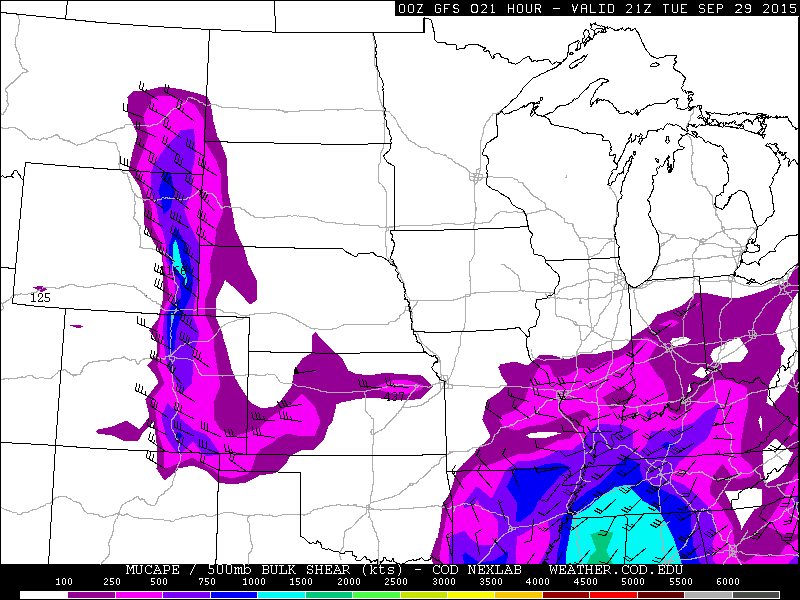
CAPE instability for Tuesday as forecasted from the GFS model
Going into Wednesday, which concludes the month of September, southeasterly winds will ensue, allowing warmer temperatures to build back into the area. Expect some clouds around early in the day, with sunshine taking over in the afternoon. Highs in Boulder should reach the low 80’s. A few showers are forecasted on Wednesday from the GFS, but expect mostly dry conditions as moisture is quite limited and forcing for precipitation is also not very strong.
By Thursday, our attention turns to a developing upper-level low pressure system, currently located in the eastern Pacific Ocean. The below plot shows the 500 mb absolute vorticity plot for Thursday as forecasted from the GFS model. We will remain dry and above average in the low 80’s. However, clouds will be on the increase in the upper levels of the atmosphere as moisture advects in from the Pacific Ocean.
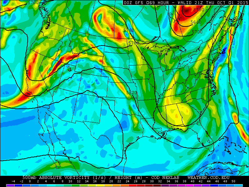
500 mb absolute vorticity for Thursday as forecasted from the GFS model
On Friday, the above mentioned low pressure system moves over Colorado. The models have been in good agreement the past few days on this developing system, tracking across Colorado Friday into Saturday. The track of this system, with cold air coming down from Canada, will likely lead to snow showers in the high country on Friday and Saturday. These snow showers could develop as early as Thursday night in western Colorado. Over Boulder County, the track of the system will be key.
700 mb temperatures will also be important on whether we see all rain or possibly a few snow flakes. This system will most definitely lower high temperatures Friday and especially Saturday, as a cold front advances through the area. Expect highs in the 70’s on Friday. However, temperatures will cool off as the day wears on. Models are showing that we could see a decent shot of rain Friday afternoon/evening with this system. However, the amount of rain will depend on the exact track of the system. Right now, brace for the best chance of rain being Friday evening.
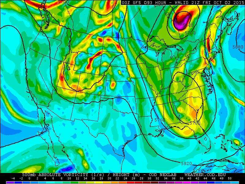
500 mb absolute vorticity for Friday as forecasted from the GFS model
On Saturday, the system moves off to the east and 700 mb temperatures drop close to 0 degrees Celsius. These temperatures will support highs struggling to get out of the 50’s on Saturday. Is this cold airmass enough for snow across Boulder County? In the Foothills, we would say yes. We would not be surprised if the highest Foothills see some light snow showers Friday night and early Saturday. In Boulder, and across the rest of the Plains, though, temperatures appear to be a little too warm for snow. However, if the system takes a more southern route, it is possible it could drag down more cold air for a few snow flakes early Saturday. The main story will be the autumn chill for Saturday, a good day to get your fireplace going!

700 temperature for Saturday as forecasted from the GFS model
The Forecast
Tuesday: Sun early, then partly cloudy. A few isolated showers or thundershowers are possible, with highs in the upper 60’s in the Foothills and mid 70’s on the Plains. Any isolated showers will taper off after sunset.
Wednesday: Clouds around early, then a mixture of clouds and sunshine. Just a slight chance of an afternoon shower. Highs warmer in the middle 70’s in the Foothills and low 80’s on the Plains.
Thursday: Mostly sunny skies with increasing clouds in the afternoon. Highs in the middle 70’s in the Foothills and lower 80’s on the Plains.
Friday: Sunshine giving way to mostly cloudy skies and rain showers developing late in the afternoon and evening. High temperatures in the mid 60’s in the Foothills and low 70’s on the Plains. Snow showers are possible over the highest Foothills Friday night and early Saturday.
Saturday: Isolated rain showers with snow showers possible in the highest Foothills. Much cooler with highs in the upper 40’s in the Foothills and upper 50’s on the Plains.
High Country Forecast:
Expect isolated rain showers today and tomorrow in the Mountains, with windy conditions and likely snow showers late Thursday night, Friday, and Saturday.
Source
Tue
Wed
Thu
Fri
Sat


BoulderCAST
76
80
82
72
58


NWS
73
80
81
72
61


AccuWeather
76
81
84
71
62


The Weather Channel
74
78
83
71
57
Last week’s recap:
Here are the results of last week’s forecast. First, the forecasts and observations:
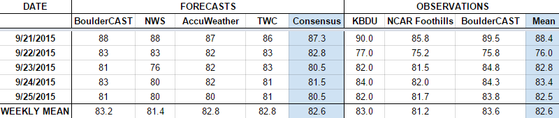
The consensus was for near-record heat on Monday, with slightly cooler temperatures the rest of the week. Some precipitation was forecast for Tuesday into Wednesday, but only a slight chance. Boulder County did not get any precipitation.
Now the error analysis. Shown is the amount of degrees (in Fahrenheit) that each source was off from the mean observed temperature for Boulder. Positive values indicate the forecast was warmer than what actually occurred, while negative values arise from a forecast that was cooler than what was observed.
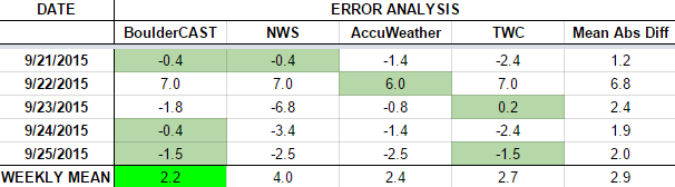
Most days this week were forecast exceptionally well by most outlets, except the NWS. The day with the largest error was Tuesday. Cloud cover from Tropical Depression 16-E was more extensive then expected, stretching northward all the way into Wyoming. This kept highs cooler than forecast (76 degrees, instead of the forecasted 83).
The bottom row of the error table shows the weekly mean error for each weather outlet, a good measure for who was the best and more consistent “forecaster” for the week. Not surprisingly, the best overall forecast for last week goes to BoulderCAST, with only 2.2 degrees of error averaged across the period, with BoulderCAST having the best forecast three days out of the week. We look to continue this trend with our forecast this week!
—
If you haven’t already done so, follow us on Twitter or Facebook for frequent weather updates and subscribe to the site to get these posts automatically delivered to your email box (enter your email in the sidebar widget to right).


You must be logged in to post a comment.