With our last measurable rainfall occurring on July 22, the monsoon seems to have taken a temporary hiatus from our region. Looking ahead, will see a large dome of high pressure build across the region, further loosening the monsoon’s grip on Colorado.
Boulder has officially recorded 2.98″ of rain thus far in July (2.86″ at BoulderCAST Station), with rain occurring on 22 out of the first 26 days of the month. However, the pattern has shifted and we have been quite dry over the last week as an upper-air ridge has pushed the bulk of the monsoon moisture to our west.
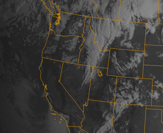
As of Monday at 8am, a fast-moving 500mb trough is located to our northwest in Montana, with a surface low and trailing front sprawling into the Great Basin. There is a ridge to our east over the Midwest (see below). Notice how the trough produces slight southwesterly flow for Colorado as it passes by. This trough will provide a glancing blow to northern Colorado as it races east-northeast, providing just enough moisture and lift to fire a few isolated to scattered afternoon thunderstorms late this afternoon.
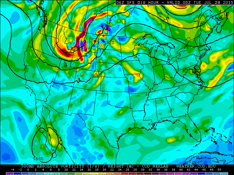
GFS 500mb vorticity map, valid at 6pm Monday, showing Monday’s “weather players.”
Meanwhile, at the surface, a lee trough develops and warm southerly flow will be in place. This will produce temperatures several degrees above seasonal normals, into the low to mid 90s on the Plains. Severe weather may be a threat northeast of Denver on Monday. However, storms in Boulder County will remain relatively docile.
Early Tuesday morning, a trailing weak cold front associated with the trough will pass through our region. With an overall lack of moisture and only light upslope, don’t expect much if anything in the way of precipitation. Temperatures for Tuesday will be 5 to 10 degrees cooler than Monday however, knocking us back into the 80s.
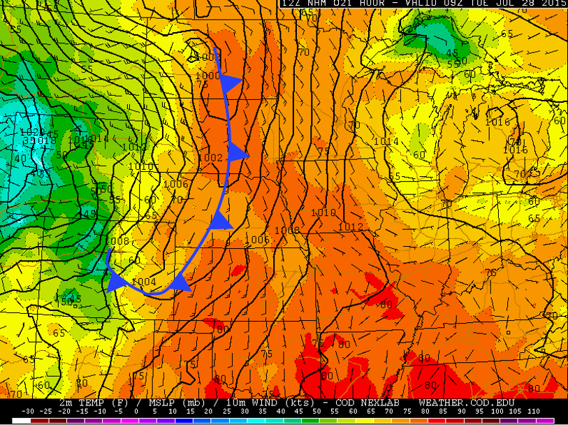
NAM surface map for Tuesday, valid at 3am. The cold front has already pushed through NE Colorado
On Wednesday, another shot of reinforcing cool air will move down into northeast Colorado. Both the GFS and NAM are showing some moist southeasterly flow producing some low clouds that linger most of the day (see below). The bulk of the development will be confined to areas south of the Palmer Divide. Depending on exactly how far north this cloud deck builds, Boulder could see some light rain/mist or isolated afternoon thunderstorms.
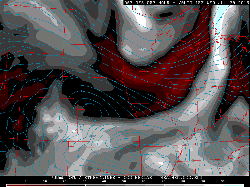
GFS 700mb relativy humidity map, valid at 11am Wednesday, depicting some low level moisture in association with the front, mostly confined to SE Colorado.
For Thursday and Friday, a ridge of high pressure begins to rebuild from east to west across the southwestern U.S. Temperatures will climb back into the 90s, with precipitation chances remaining quite low, thanks to the west-northwesterly flow aloft. Both days will have plentiful sunshine, but Friday may bring northward an outside chance of a thunderstorm in the afternoon.
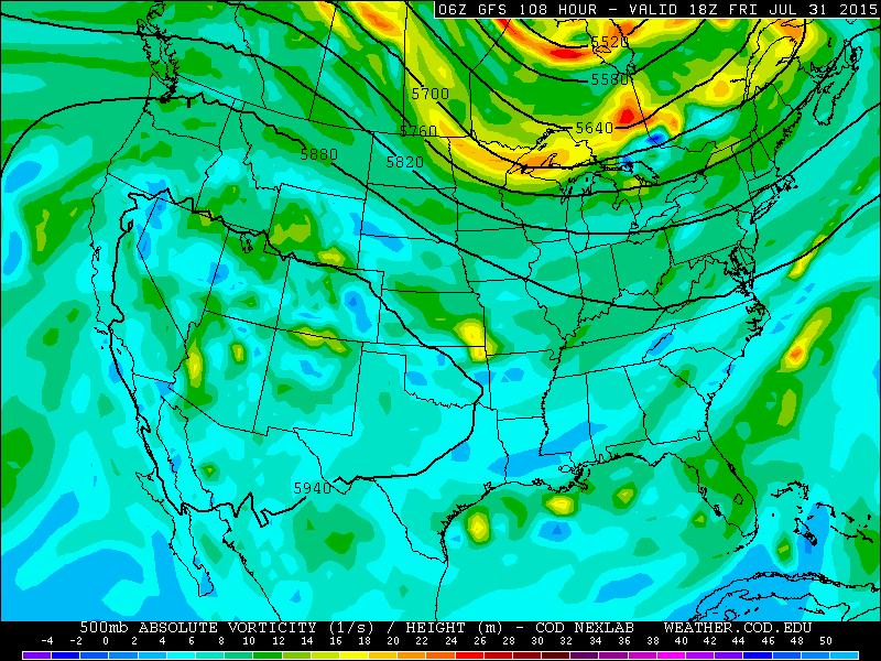
GFS 500mb vorticity map, valid at noon Friday, depicting a large ridge building across the Western USA.
The Forecast for Boulder County:
Monday: Mostly sunny with clouds increasing . Isolated to scattered storms forming in the afternoon, first and more numerous over the higher terrain. High temperatures in the low to mid 90s on the Plains, mid 80s in the Foothills.
Tuesday: Mostly sunny, dry and cooler, thanks to a pre-dawn cold front passage. High temperatures in the mid to upper 80s on the Plains, with 70s in the Foothills.
Wednesday: Partly cloudy, with low clouds potentially building through the day. A slight risk of isolated showers, with a few embedded lightning strikes. Highs struggling to reach into the low 80s on the Plains and Foothills.
Thursday: Warmer and sunny, with high temperatures in the upper 80s on the Plains, with upper 70s in the Foothills.
Friday: Mostly sunny with a slight risk of isolated afternoon storms in the Foothills. Highs in the low 90s on the Plains, with low to mid 80s in the Foothills.
Source
Mon
Tue
Wed
Thu
Fri


BoulderCAST
94
86
83
89
91


NWS
93
86
82
87
90


The Weather Channel
91
85
82
87
88


AccuWeather
90
87
83
90
90
Last week’s recap:
Here are the results of last week’s forecast. First, the forecasts and observations:

The consensus was for a cool start to the week, with Tuesday being the coldest under clouds with high chances for rain. For the last half of the week, a building ridge was expected with temperatures warming back into the 90s.
Now the error analysis. Shown is the amount of degrees (in Fahrenheit) that each source was off from the mean observed temperature for Boulder. Positive values indicate the forecast was warmer than what actually occurred, while negative values arise from a forecast that was cooler than what was observed.
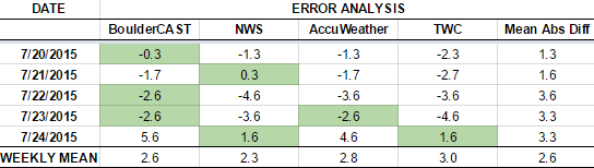
Both Monday and Tuesday verified quite well, but all sources forecasted too cold on Wednesday and Thursday. On Friday, a thick deck of mid-level clouds developed that kept temperatures much cooler than forecast. Five days out, it is very difficult to predict these clouds, particularly when the models didn’t contain the necessary moisture. Running the numbers, BoulderCAST had the best forecast on Monday, Wednesday, and Thursday! Woo! Go us!
The bottom row of the error table shows the weekly mean error for each weather outlet, a good measure for who was the best and more consistent “forecaster” for the week. In the end, the best overall forecast for the entire week goes to the NWS, barley beating us out but 0.3 degrees!
—
If you haven’t already done so, follow us on Twitter or Facebook for frequent weather updates and subscribe to the site to get these posts automatically delivered to your email box (enter your email in the sidebar widget to right).


You must be logged in to post a comment.