After a rather dry weekend, outside of a few storms on Saturday, we return to another wet pattern to begin the week under monsoonal flow. However, drying appears to commence late in the week with those pesky 90’s returning once again.
The current surface analysis is shown below. It indicates a cold front to our northeast over northern Nebraska, stretching northwestward into Montana. This front will edge closer as we go through the day. However, it likely won’t have enough push to move through our region. A surface trough will likely bring us northeasterly winds this afternoon, resulting in a slight upslope flow.
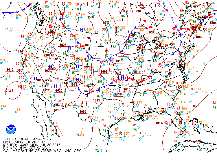
Current surface analysis as of this Monday morning.
In the upper levels, a jet streak is located to the north of Colorado over Wyoming and Nebraska. This is connected to an upper-level trough in the western US. Along with this, an upper-level shortwave is over southwestern Wyoming today. By this evening, Boulder is near the right entrance region of this upper level jet, as indicated below in the graphic. This coupled with decent moisture with monsoon flow and weak surface upslope will lead to development of scattered showers and storms by late afternoon and early evening. Most of the models are indicating a majority of these storms to be south and west of Boulder County in association with the upper-level jet streak. However, it appears the ingredients are in place for at least some storms to reach us.
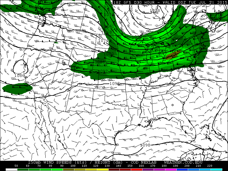
250 mb upper level winds for this evening from the GFS model.
As we go into Tuesday, we remain under a weak upslope flow. This time, it becomes southeasterly in the lower levels, as depicted in the 850mb plot below, which shows both dew point temperature and vector winds. Moisture on Tuesday is also higher than on Monday, with precipitable water values at or above 1 inch. In addition, surface-based instability is also larger, with the GFS showing CAPE values between 1000 and 1500 J/kg. The plot below shows the 00Z GFS run from last night. The current run shows slightly lower values ~ 1000 J/kg. Nevertheless, it looks like Tuesday will be much wetter than Monday with plenty of moisture and instability on the table.

850 mb plot of moisture and wind for Tuesday from the GFS model
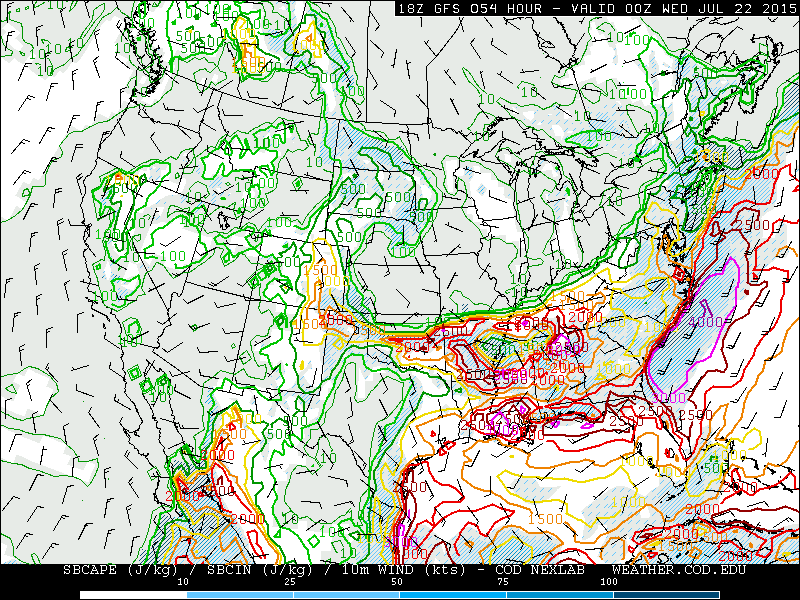
Convective Available Potential Energy (CAPE) for Tuesday from the GFS model
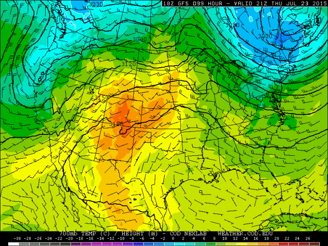
As we go into Wednesday, Thursday, and Friday, the upper-level flow remains monsoonal (southwesterly), as indicated in the 500mb plot below. However, moisture decreases as we go through the end of work week as the strongest flow pushes to our west into Utah and Nevada. Precipitable water values decrease to near 0.4 inches by Friday compared to over an inch on Tuesday. Instability also is reduced. Coupled with this is warming in the mid levels of the atmosphere at 700mb, with temperatures near 18 degrees Celsius by Thursday and Friday. This equates to lower 90’s for our high temperatures, beginning Thursday and continuing into Friday. At the surface, a lee trough signature indicative of downslope flow will ensue late in the week as well. So while we are still in a monsoon flow with a few isolated storms possible, our chances decrease late in the week due to the aforementioned decrease in moisture, instability, and surface downslope winds.
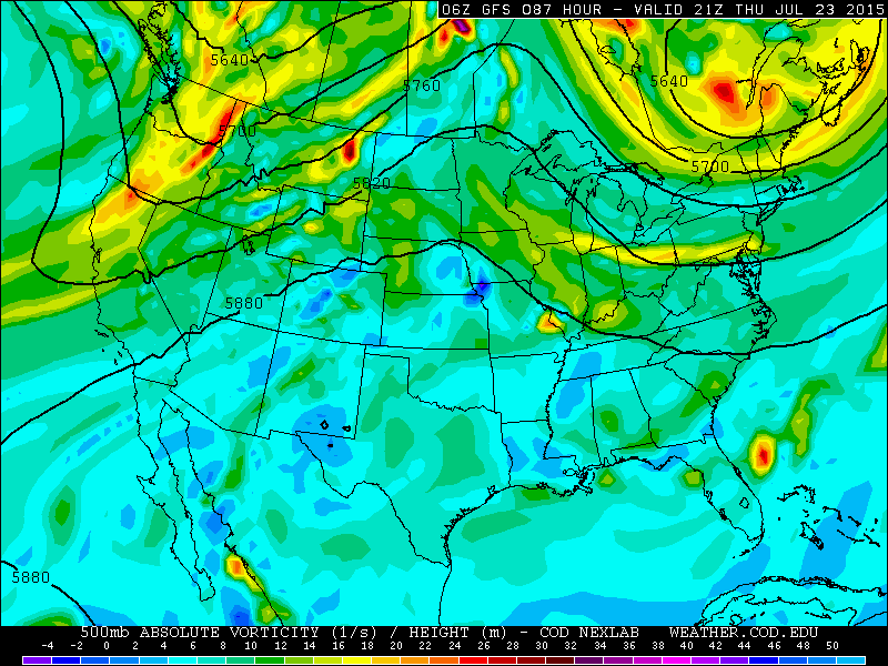
500 mb vorticity and heights for Thursday from the GFS model
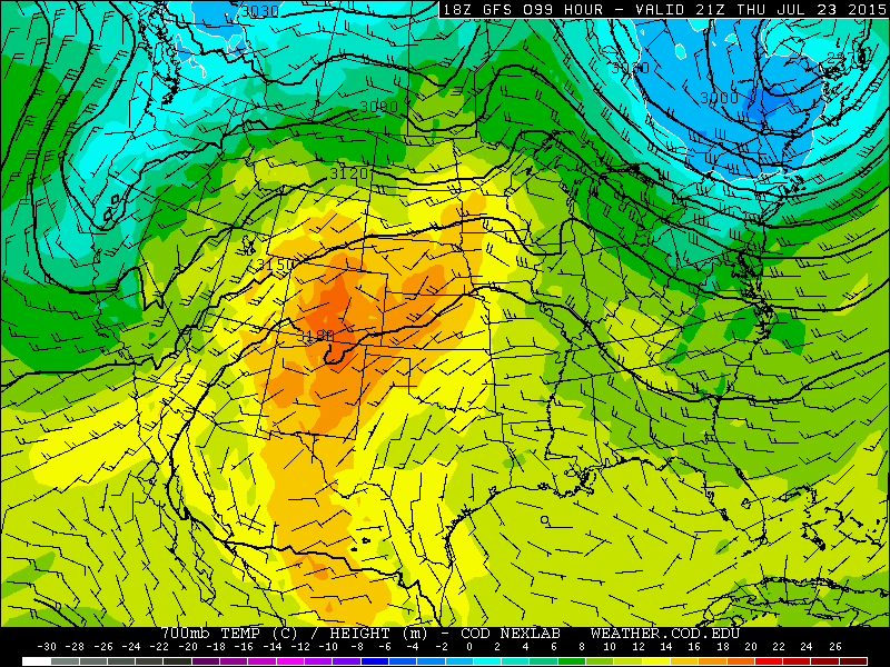
700 mb temperature and height for Thursday from the GFS model
The Forecast for Boulder County:
Monday: Sunny skies giving way to increasing clouds with isolated to scattered storms by late afternoon/early evening. High in the mid 80s on the Plains, upper 70s in the Foothills.
Tuesday: The “wet” day of the week. Sunny skies becoming mostly cloudy in the afternoon with showers and storms developing, some could produce brief heavy rain. Rain tapering off by midnight. Highs in the upper 70s for the Plains, mid 70s in the Foothills.
Wednesday: Mostly sunny with afternoon clouds and a few isolated storms in the late afternoon/early evening. Highs in the upper 80s on the Plains, low 80s in the Foothills.
Thursday: Lots of sunshine, with just a slight chance of an isolated afternoon storm, with the best chance in the Foothills. Warmer with high temperatures in the low 90s across the Plains, mid 80s in the Foothills.
Friday: Mostly Sunny with just a slight chance of an isolated storm. High temperatures in the low to mid 90s on the Plains, with mid 80s in the Foothills.
Source
Mon
Tue
Wed
Thu
Fri


BoulderCAST
83
79
87
92
92


NWS
82
81
85
91
88


The Weather Channel
81
78
86
90
88


AccuWeather
82
79
86
92
91
Last week’s recap:
Here are the results of last week’s forecast. First, the forecasts and observations:
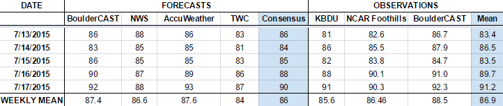
The general consensus was for rain and an ever-so-slight cool down on Tuesday, with warming and drying through the rest of the week. The models were mostly on track, but storms remained around through the week, a little more numerous than expected.
Now the error analysis. Shown is the amount of degrees (in Fahrenheit) that each source was off from the mean observed temperature for Boulder. Positive values indicate the forecast was warmer than what actually occurred, while negative values arise from a forecast that was cooler than what was observed.
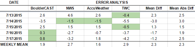
BoulderCAST had the worst forecast on Wednesday, but ended with the best forecasts for Thursday and Friday. We forecasted too cold on Tuesday, as we were expecting clouds and storms to be numerous and develop early. In the end, mixed sun kept our temperatures warm and the first storm didn’t arrive until 4pm. We nailed the end of week warming, forecasting to less than 1 degree error on both days!
The bottom row of the error table shows the weekly mean error for each weather outlet, a good measure for who was the best and more consistent “forecaster” for the week. BoulderCAST came in second place, just behind AccuWeather, with an average of 1.9 degrees error through the week. After doing the best last time, The Weather Channel performed the poorest this week (a.k.a. the norm).
—
If you haven’t already done so, follow us on Twitter or Facebook for frequent weather updates and subscribe to the site to get these posts automatically delivered to your email box (enter your email in the sidebar widget to right).


You must be logged in to post a comment.