Following a mild weekend, the week ahead will be dominated by mostly sunny conditions across the lower elevations, with a significant warm-up likely to end the week. Read on for our full forecast!
Mother Nature brought ideal conditions yesterday for the Broncos nail-biter at Sports Authority Field. Temperatures were near 50 degrees under mostly sunny skies with light winds. Stephen Gostkowski might argue that last part, though. Hopefully the weather will cooperate as much when the Broncos travel to Santa Clara for Super Bowl 50 in two weeks!
Storm of the (Twenty-First) Century?
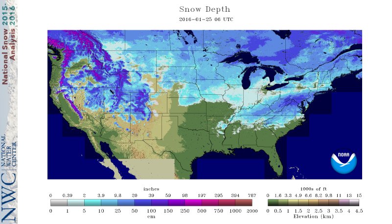
Outside of the Denver-bubble, this past weekend’s news was dominated by the historic blizzard that pounded the northeast with up to 40 inches of snow. It was the biggest single-storm snow event on record for many of the cities along the I-95 Corridor! More than a foot of snow was reported in 14 different states, which is absolutely incredible! Total snow accumulations for the event can be seen below.
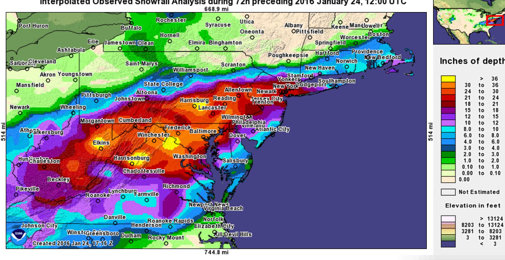
Northeast Snow Totals – January 22-23, 2016 Blizzard | NOAA
Though irrelevant to Colorado, we were tracking the storm very closely. Forecasters may only get a chance to battle with a beast like that once every decade or two! Despite the NAM model being an outlier with it’s northward storm track, it ended up nailing it with near perfection. The GFS was just a little too far south, while the Euro was out to lunch. A rare victory for the NAM! With the extreme gradient in snow amounts along the northern side of the storm (see above), this shift had major implications, bringing 20+ inches of snow northward to encompass Philadelphia, Newark, New York City, and Long Island.
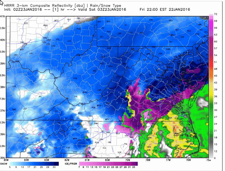
HRRR model simulated reflectivity for the storm An extended period (24+ hours) of heavy snow was observed just about everywhere!
It’s worth noting that many of the models (and therefore, news outlets) actually picked up on this historic blizzard more than seven days in advance. This is remarkable, but more dumb luck that anything. Having a storm system evolve as depicted by the models so far out is rare. We see a “monster blizzard” in the 8 to 10 day model forecasts a few times per month on average. These rarely materialize into much. This storm will undoubtedly give the media a misguided sense of confidence in longer range models over the next few months, spawning more bull-headed posts warning that a blizzard is headed straight for the major cities in a week’s time. We know better, so don’t expect false hype from us. We tell it like it is, no matter how mundane and lack-luster Boulder’s weather can be in the middle of January!
Boulder/Denver hasn’t seen a snow storm of this caliber in many years; arguably since December of 2006, when a monster storm dumped 32″ in Boulder and 22″ in Denver. But with El Nino in place, this could be our year, too. Only time will tell.
Photo taken by a friend, Emy Kane, in NYC, appropriately captioned “Eskimo Kisses.”
The Week Ahead…
On the complete opposite end of the spectrum, the Front Range was feeling like Spring this weekend! Thanks to southwest flow, downslope winds, and abundant sunshine, Saturday soared to 65 degrees in Boulder, our first 60-degree day in more than six weeks.
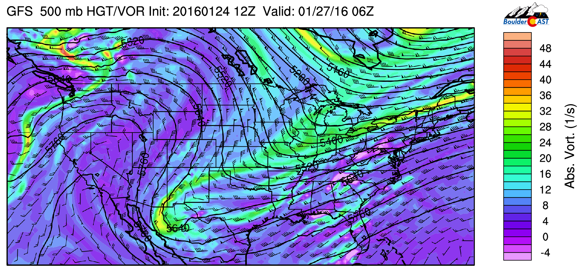
With yesterday’s cold front, things are now a little more seasonal. Colorado is currently parked beneath a broad but weak upper-level trough.
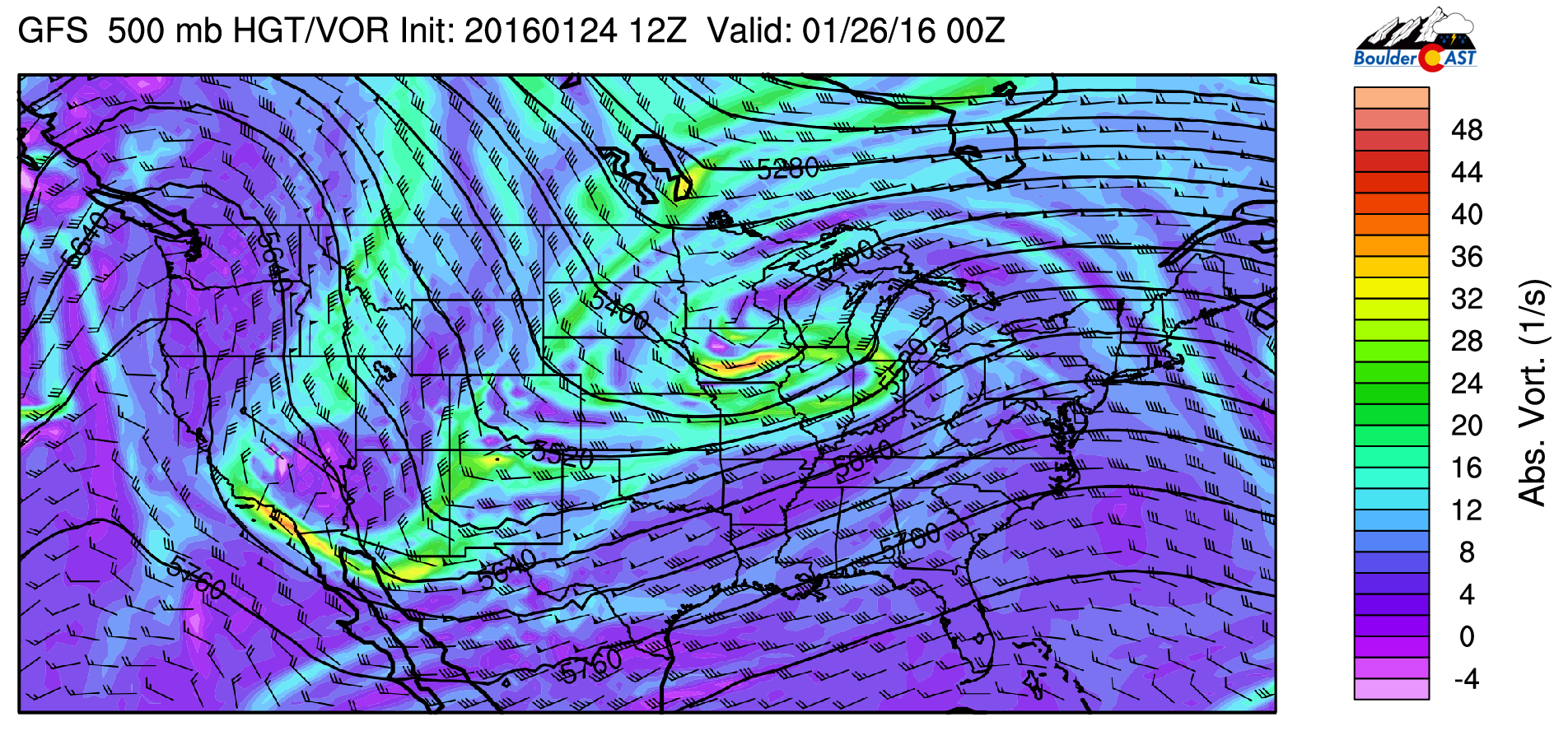
GFS 500mb vorticity map for Monday afternoon, showing a disorganized trough encompassing the area.
The main energy is trailing into Iowa, but a weaker trough axis does extend southward through Colorado into Arizona. This is the system responsible for last night’s snow showers/flurries and cloud cover. We are only expecting isolated light snow showers across the Plains and Foothills this morning. By late evening, snow chances diminish. Favored, northwest slopes in the Mountains will have picked up 6+” with this system, while the Plains will generally see less than 1/2″ of snow accumulation. With a cool airmass in place, highs will only top out into the mid 30’s this afternoon with partly cloudy skies.
Those few snow showers today are the only chance of precipitation this week. A more potent ridge takes over Tuesday and builds through the week. Here is the ridge on Wednesday afternoon, extending from California, northeastward into Canada
GFS 500mb vorticity map, valid Tuesday night. A large-amplitude ridge approaches from the west.
We will see sunshine and moderating temperatures as the week progresses as drier air takes hold on the state. Notice how the cold air only glances Colorado on Monday, sliding eastward by Wednesday.
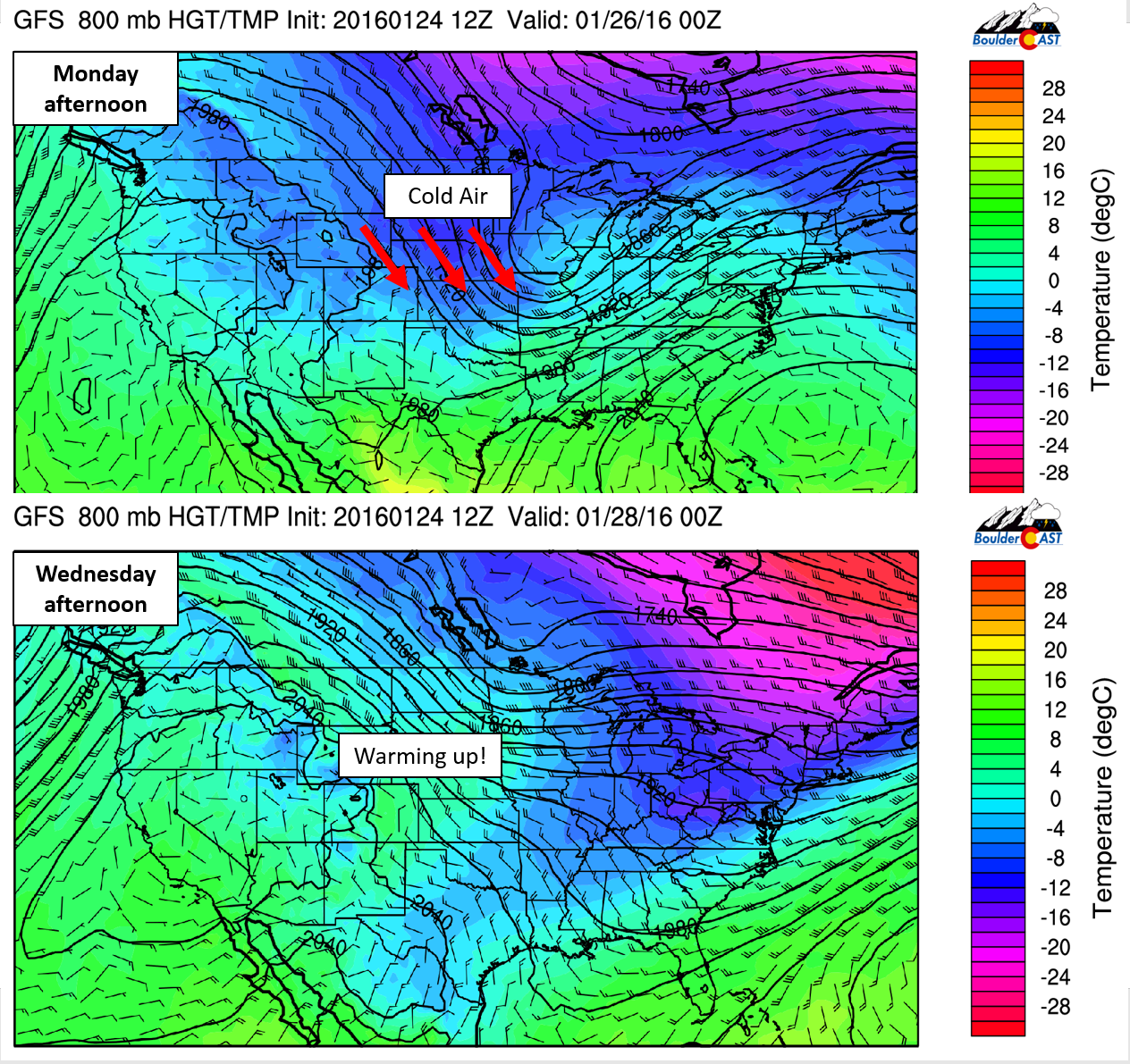
GFS 800mb temperatures for Monday afternoon (top) and Wednesday afternoon (bottom). Notice how the cold air quickly slides eastward, with warmer temps building across eastern Colorado.
Monday will be in the mid 30’s, Tuesday near 40, Wednesday near 50, and Thursday in the mid 50’s. Friday could see temperatures climb into the low 60’s as the ridge continues to dominate our weather.
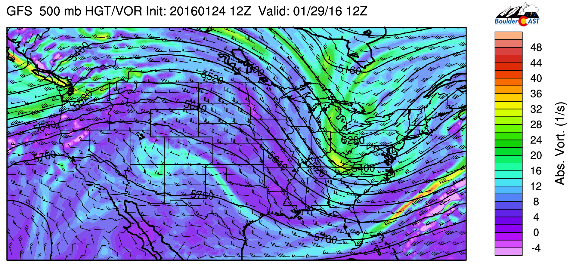
GFS 500mb vorticity map for Friday morning. A large ridge dominates most of the western United States. A plume of Pacific moisture and energy can be seen moving into the Northwest USA. This will bring a return of snow to the mountains this weekend.
Our next chance for snow is, in all likelihood, at least a week away.
Models have been somewhat consistent with bringing at least “something” into Colorado in the first few days of February. However, more than a week out, it is too early to say much more. For now, make the most of the warmer weather or get to the snowy High Country. Andy said the skiing is phenomenal out there right now! Well keep you updated, so be sure to subscribe.
We leave you with a video from Virginia during #Blizzard2016. This is what 3 feet of snow falling in less than 24 hours looks like!
.
The Forecast:
Monday: Partly sunny. Light snow or flurries are possible through the day. Little to no accumulation is expected. Highs in the mid 30’s for the Plains, with upper 20’s in the Foothills.
Tuesday: A few morning clouds with mostly sunny skies is in the afternoon. Highs near 40 across the Plains with low 30’s in the Foothills.
Wednesday: Sunny and mild. Highs in the low 50’s across the Plains, with low 40’s in the Foothills.
Thursday: Sunny. Warmer with temperatures in the mid 50’s on the Plains and upper 40’s in the Foothills.
Friday: Mostly sunny and warm. Highs near 60 on the Plains and low 50’s in the Foothills.
High Country Forecast: Light snow will continue into Tuesday morning in the Mountains, with total accumulations of 4 to 10 inches. Dry and warmer weather takes over Wednesday into Friday, with the chance of light snow returning before the end of the weekend.
Source
Mon
Tue
Wed
Thu
Fri


BoulderCAST
38
41
52
54
58


NWS
35
40
49
55
58


AccuWeather
38
41
50
54
56


The Weather Channel
38
40
51
54
60
Last week’s recap:
Here are the results of last week’s forecast. First, the forecasts and observations from all of the sources:
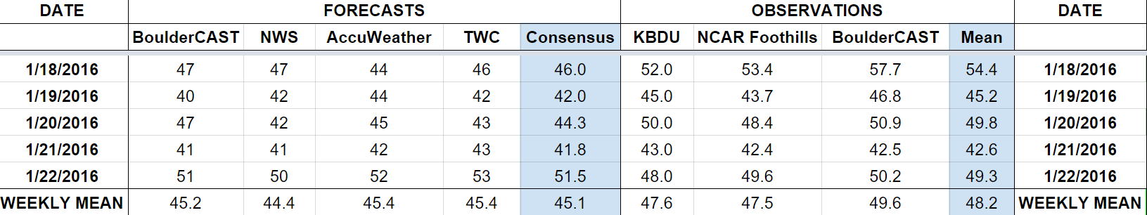
Last week saw the active storm track continue across Colorado, with frequent but mostly dry storms moving across the state through the week. We mentioned the slight chance of snow Tuesday morning and Wednesday evening. Boulder picked up 0.6″ of snow on Tuesday, but nothing on Wednesday. Temperatures were in the 40’s and 50’s.
Let’s look at the error analysis. Shown below is the amount of degrees (in Fahrenheit) that each source was off from the mean observed temperature for Boulder. Positive values indicate the forecast was warmer than what actually occurred, while negative values arise from a forecast that was cooler than what was observed.
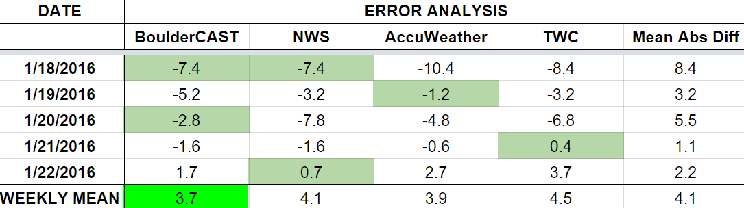
Two difficult forecast days this week. The worst day was Monday, with more than 8 degrees of error. Models indicated extensive high cloud cover, but there was a good deal of sunshine actually. This helped push temps to 54 (way above the forecast of 46). Wednesday also saw relatively large forecast error. Lately temperatures have tended to blow beyond forecasts. We will need to keep that in mind moving forward.
The bottom row of the error table shows the weekly mean error for each weather outlet, a good measure for who was the best and more consistent “forecaster” for the week. BoulderCAST is once again in first place this week, with 3.7 degrees of error, just edging out AccuWeather. This marks our third consecutive week in first place.


You must be logged in to post a comment.