This week will feature a series of snow events across the High Country, with several ski resorts likely accumulating more than a foot of snow by midweek. This is all thanks to a large Pacific jet stream tracking into the western United States. There are also hints Boulder may see some snow on Christmas. Continue to find out more.
It’s been a relatively quiet weekend across Boulder County, albeit on the cool side with still plenty of snow on the ground from last week’s snow storm. Pleasant and mild weather will continue, however, at least into Tuesday, before a cold snap takes over on Wednesday into the holiday weekend.
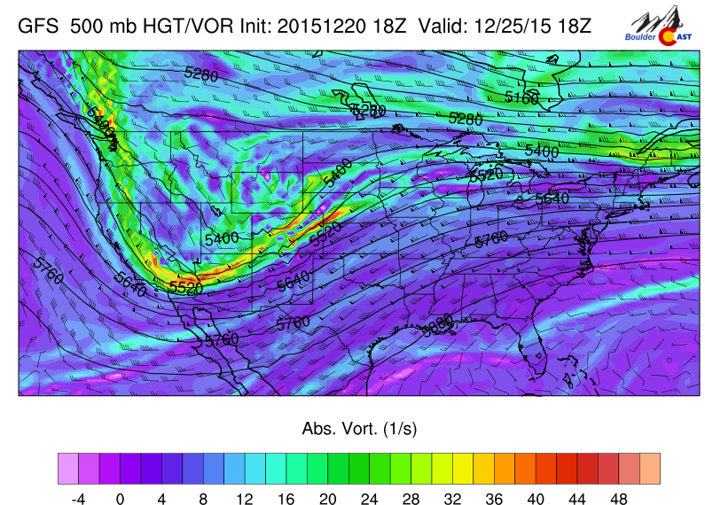
Below shows the mid-level 500 mb absolute vorticity plot for Monday from the GFS model, indicating a broad region of westerly flow stretching from California into western Colorado.
A trough is located in the Pacific and will be responsible for producing several snow squalls in the High Country from tonight and into Wednesday. Meanwhile, in the lower elevations, this westerly flow will lead to downslope conditions in Boulder Monday and Tuesday. That will facilitate temperatures rising into the mid and upper 40’s these next few days.
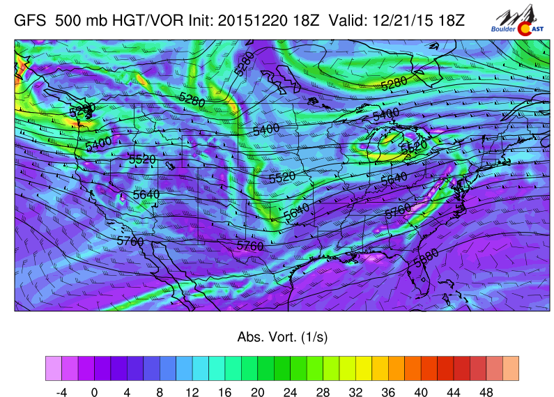
500 mb Absolute vorticity for this afternoon from the GFS
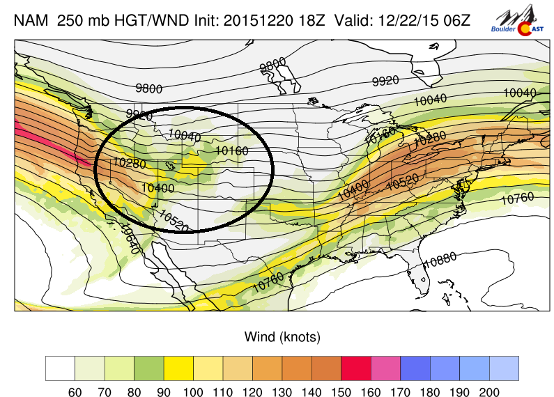
Also of note is that this westerly flow will likely lead to windy conditions a starting late Monday night and into early morning on Tuesday. Below shows the GFS forecast at the 700 mb level for Monday night. As is evident, there is a slight kink in the height lines over central Colorado. There is also a region of warming temperatures in eastern Colorado, along with winds aloft up to 50 mph. Although not a certainty, its a good chance another wind storm will ensue late tonight into early tomorrow, so hold on to your hats! This is all thanks to the jet stream pushing in from the Pacific.
700 mb temperature and wind for Monday night
Now back to the snow in the High County and our ski resorts. Below shows the NAM model 84 hour total snow accumulation. As you can see, the model depicts a large portion of western Colorado to see over 8 inches of snow, with some locations, such as Steamboat, possibly accumulating over a foot. The GFS model shows even more snowfall. So if you are planning to ski this week, expect several powder days, especially in the more western resorts!

NAM total snow accumulation by Thursday
Tuesday looks to be our warmest day across Boulder, thanks to westerly downslope winds. It’s possible we could briefly touch 50 degrees. Though with the snow on the ground, that may be tough.
As we head into Wednesday, a cold front will drop down from Wyoming and lead to ensuing northeast flow, with temperatures falling back into the upper 30’s. Below shows the 800 mb (just above the surface) temperatures for Wednesday, showing the cold air moving southward behind a trough in the Midwest.
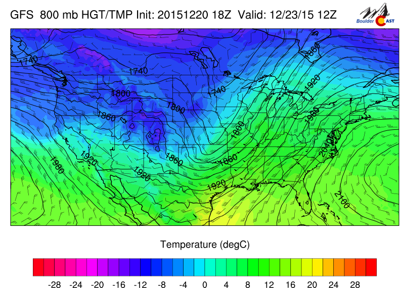
GFS 800 mb temperature for Wednesday
This chilly pattern remains through Thursday and even on Friday as east-northeast winds continue to bring in cold air from the east. This is also an upslope flow, which will keep the cold air entrenched.
As we go into Friday, the models diverge in regards to a potential Christmas day snow event in Boulder.
Below shows the GFS and Euro forecast for Friday.
GFS 500 mb vorticity for Friday
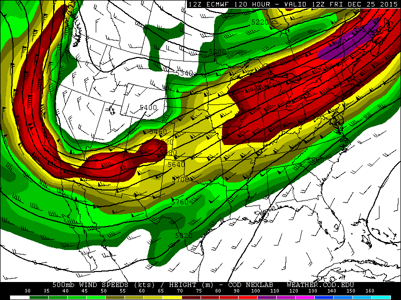
ECMWF 500 mb winds and heights for Friday
As you may notice, both models show consistently a trough diving south across northern Arizona early on Friday. The models then eject this feature northeast by the holiday weekend. Ahead of the trough, vorticity advection and possible jet streak divergence aloft would lead to potential snow across the Plains. This particular track, however, does not look too conducive to a large snow event, especially for the High Country. However, the models are likely to hone in on a solution over the next few days. It is still four days out. Just know that there is the chance Christmas day could be white! We’ll be sure to update you later in the week if the storm materializes.
If you don’t hear from us between now and then:
Merry Christmas,
from the meteorologists at BoulderCAST!
The Forecast:
Monday: Partly sunny and cool, highs in the low to middle 40’s on the Plains and upper 30’s in the Foothills.
Monday Night: Westerly downslope flow will ensue across Boulder County, and although not a certainty, its likely that gusty winds will develop late around midnight and continue into Tuesday morning. These winds could reach 40 to 50 mph at times.
Tuesday: Partly sunny with lots of high clouds streaming in from the west. Westerly winds gusty at 20-25 mph in the afternoon with highs in the upper 40’s across the plains and lower 40’s in the Foothills.
Wednesday: Partly sunny and cooler, a slight chance of a few snow flurries, otherwise dry and chillier with upper 30’s across the Plains and lower 30’s in the Foothills.
Thursday: Mostly sunny and chilly, temperatures to stay on the cold side with highs in the lower 30’s on the Plains and middle 20’s in the Foothills.
Friday: Increasing clouds with snow possible in the late afternoon and early evening. Highs in the low 30’s on the Plains and lower 20’s in the Foothills.
Extended Outlook: Cold weather remains in place through the holiday weekend. A break may ensue Sunday with the jet stream shifting further north. Dry weather takes over for the weekend with the next shot of snow possibly arriving early next week.
High Country Forecast: Expect several periods of snowfall starting tonight into early Wednesday across much of western Colorado. Several locations will see over a foot of snow, with some spots over 2 feet. The weather relaxes Thursday, after which another chance of snow comes Christmas day into the holiday weekend.
Source
Mon
Tue
Wed
Thu
Fri


BoulderCAST
46
48
37
32
29


NWS
42
45
36
29
29


AccuWeather
42
47
38
34
31


The Weather Channel
42
44
37
34
31
Last week’s recap:
Here are the results of last week’s forecast. First, the forecasts and observations from all of the sources:

Last week began with a surprise snow storm Monday night, with Boulder officially picking up 11.3″. Read our recap post for a better understanding of what happened. In the wake of that system, temperatures were to remain cool. We also predicted a few snow flurries Thursday alongside another weak front, which did verify for Boulder.
Let’s look at the error analysis. Shown below is the amount of degrees (in Fahrenheit) that each source was off from the mean observed temperature for Boulder. Positive values indicate the forecast was warmer than what actually occurred, while negative values arise from a forecast that was cooler than what was observed.
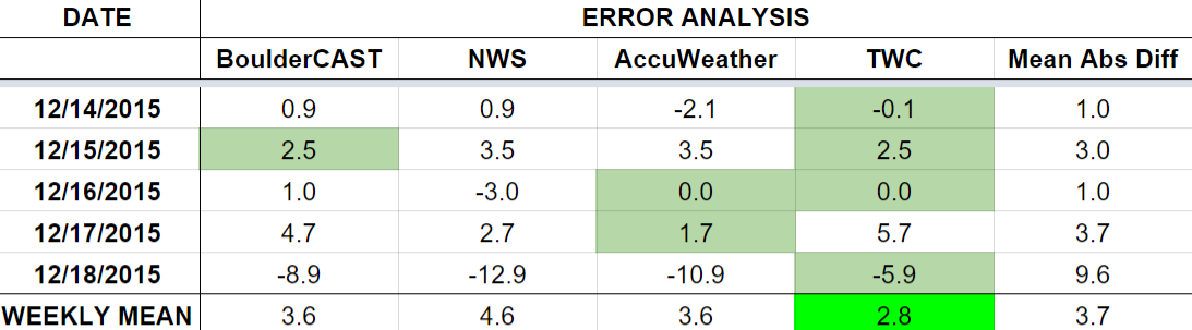
The worst forecast day of the week by far was Friday, with nearly 10 degrees of error averaged across the board. Temperatures warmed to 53 degrees (above the forecast of 43). Our temperatures rebounded remarkably well, despite Thursday’s cold front and significant snow still on the ground. Every other day of the week was forecast quite good.
The bottom row of the error table shows the weekly mean error for each weather outlet, a good measure for who was the best and more consistent “forecaster” for the week. Surprisingly, the Weather Channel lands in first place, with just 2.8 degrees of error. BoulderCAST fell just short, and takes second place, having the best forecast on Tuesday.


You must be logged in to post a comment.